Images of Old Hawaiʻi

  • Home
  • About
  • Categories
    • Ali’i / Chiefs / Governance
    • American Protestant Mission
    • Buildings
    • Collections
    • Economy
    • Missionaries / Churches / Religious Buildings
    • General
    • Hawaiian Traditions
    • Other Summaries
    • Mayflower Summaries
    • Mayflower Full Summaries
    • Military
    • Place Names
    • Prominent People
    • Schools
    • Sailing, Shipping & Shipwrecks
    • Voyage of the Thaddeus
  • Collections
  • Contact
  • Follow

January 2, 2023 by Peter T Young Leave a Comment

Pacific Jungle Combat Training Center

Prior to World War II, Kahana and Punalu‘u Valleys were primarily used for agricultural activities.  Taro, rice, and sugar cane were cultivated at the mouths of each valley.  The interior portions of the valleys were heavily vegetated and relatively unused.

The Army initially leased 485.25 acres in Kahana Valley from Hui of Kahana in November 1944, retroactive to May 1943.  Between 1943 and 1947, the Army acquired an additional 1,781.52 acres in the neighboring Punalu‘u Valley from various landowners through leases, licenses, and permits.

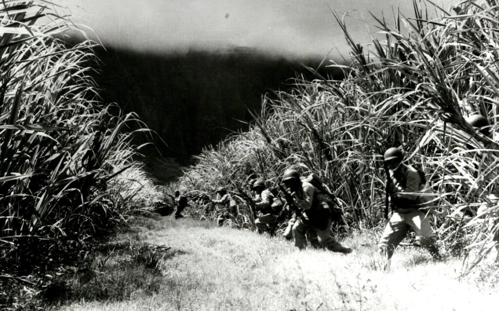
In response to an August 9, 1943 directive from the Commanding General, Hawaiian Department, Pacific Jungle Combat Training Center (CTC) was established as a school on Oahu to supplement Department Ranger and Combat School training.

It was located on the northeastern side of the island of Oahu totaling approximately 2,545 acres in the adjacent valleys of Punalu‘u and Kahana in the district of Ko‘olauloa.

Pacific Jungle CTC was also known as Unit Jungle Training Center, Unit Combat Training Center, Pacific Combat Training Center, Jungle Training, Punaluu Training Camp and Green Valley Jungle Training Camp.

Punalu‘u Valley being referred to as “Green Valley” by the Army while Kahana Valley was designated “Red Valley” during utilization of the valleys as a training area.

An Army-built coral-surfaced service road is still referred to as “Green Valley Road” by area residents. This road is also designated by Oahu Civil Defense Agency as an evacuation route to allow coastal inhabitants access to higher ground in the event of a tsunami.

Beginning in September 1943 (during World War II), this property was used as a unit-level jungle combat training center.  The Center was divided into three courses: Red, Blue, and Green.

Basic warfare training was conducted at the Red and Blue courses while advanced warfare training and Instructor Jungle Training School were conducted at the Green course.

Subjects taught during a one-week course included jungle first aid and evacuation, hand-to-hand combat training, construction and passage of wire entanglements, booby traps, patrolling and ambushing, assault of Japanese fortified areas, combat reaction proficiency, and jungle living.

The Army reportedly constructed Japanese villages and pillboxes for training purposes.  Temporary barracks, a mess hall, a bakery, and shower facilities were also erected though no longer exist.

Advanced training on Green Course was discontinued on 28 May 1944 after only its second class as it became necessary to utilize the course for basic jungle warfare training of divisions being staged for the Western Carolines operations.

Jungle warfare was de-emphasized as the war progressed from tropical regions to areas where jungle fighting was not a primary consideration.

All jungle training centers became known as Unit Combat Training Centers in March 1945. On month later, it was redesignated as Pacific Combat Training Center to deemphasize jungle warfare.  Over 241,000 men received basic, advance, or instructor training at the center.

Munitions known to have been used or recovered at the site include 75mm armor piercing rounds, 2.36-inch rockets, MKII hand grenades, rifle grenades, 105mm high explosive rounds, 81mm high explosive and practice mortar rounds, and small arms.

Postwar plans called for closing the majority of the center except for the Green Course in Punalu‘u Valley, which was to be retained to fulfill the Army’s postwar training requirements.

The Army re-opened Punalu‘u Valley on April 1, 1946 to provide emergency shelter for area residents displaced by a tsunami.  Tents were erected for sleeping quarters, to render medical treatment, and to feed approximate 1,700 individuals.

Parcels in Kahana Valley were returned to previous landowners in August 1946.  The leases, licenses, and permits for parcels in Punalu‘u Valley terminated between April 1945 and November 1950 and were reverted back to previous owners.

The Punalu‘u Valley parcels are primarily owned by Kamehameha Schools.  The Kahana Valley parcels are now owned by the State of Hawai‘i and managed by the DNLR, Division of State Parks.

The Kahana Valley parcels are located in the Ahupuaʻa ʻO Kahana State Park. The park was established as a “living park” with the primary purpose to nurture and foster native Hawaiian cultural traditions and the cultural landscape of rural windward Oahu.   (All here is from the Army Corps of Engineers.)

© 2023 Ho‘okuleana LLC

Filed Under: Military Tagged With: Ahupuaa O Kahana State Park, Pacific Jungle Training Center, Punaluu, Kahana, Army, Marines, Navy

November 5, 2022 by Peter T Young Leave a Comment

Kahana

Forever I shall sing the praises
Of Kahana’s beauty unsurpassed
The fragrance of beauteous mountains
By the zephyrs to thee is wafted
(Written for Mary Foster and her country home at Kahana)

The island of Oʻahu is divided into 6 moku (districts), consisting of: ‘Ewa, Kona, Koʻolauloa, Koʻolaupoko, Waialua and Waiʻanae. These moku were further divided into 86 ahupua‘a (land divisions within the moku.)

Kahana (Lit., the work, cutting or turning point;) approximately 5,250-acres, is one of the 32 ahupua‘a that make up the moku of Koʻolauloa on the windward and north shore side of the island.  It extends from the top of the Koʻolau mountain (at approximate the 2,700-foot elevation) down to the ocean.

The ahupuaʻa of Kahana, like all land in Hawai`i prior to the Great Māhele of 1848, belonged to the King. It is estimated that a population of 600 – 1,000 people lived here at the time of the arrival of Captain Cook (1778,) and about 200 at the time of the Māhele.

Much of the lower marshland surrounding the river was planted with taro; the higher dryland area leading to the ridges on both sides of the river was planted with trees, sugar cane, banana and sweet potato.  Groves of bamboo, ti leaves, kukui and hala trees at various locations indicate significant areas of ancient dwelling places.  (Kaʻanaʻana)

Ane Keohokālole, mother of King Kalākaua and Queen Liliʻuokalani received the bulk of the ahupuaʻa of Kahana at the Māhele; several kuleana awards to makaʻāinana (commoners) were scattered in the valley, as well as land for a school and roads.

Keohokālole received 5,050-acres, and the kuleana awards totaled less than 200-acres (the kuleana lands included the house lots and taro loʻi of the makaʻāinana.) The remainder of the ahupuaʻa included undeveloped uplands.

In 1856, Keohokālole and her husband Kapaʻakea created an asset pool, a type of trust.  As trustee, Keohokālole later sold Kahana (May 1857) to AhSing (also known as Apakana,) a Chinese merchant.  (LRB)

These lands later passed through the hands of a few other Chinese merchants  before being bought by a land hui composed of Hawaiian members of the Church of Jesus Chris Latter Day Saints, called the Ka Hui Kuʻai i ka ʻĀina ʻo Kahana in 1874. The hui had 95 members; most members getting one share, and a few receiving multiple shares.  (LRB)

The hui movement was not isolated to Kahana, it was throughout the Islands.  They were formed as an attempt to retain or reestablish part of the old system that predated private ownership granted through the Māhele.  (Stauffer)

Here, each shareholder had his or her own house lot and taro loʻi, but all had an undivided interest in the pasture and uplands, and in the freshwater rights, ocean fishing rights and Huilua fishpond.

Each member was allowed an equal share in the akule that were caught, and could have up to six animals running freely on the land (additional animals would be paid at a quarter per year.)  (LRB)

When the call came in the late-1880s for Mormons to gather at Salt Lake City, many from Kahana wanted to leave for Utah with other Hawaiian Mormons; at least a third of the founders of the Hawaiian Mormon Iosepa (Joseph) Colony in Utah were from Kahana.  (Stauffer)

Then, Mary Foster (daughter of James Robinson and wife of Thomas Foster – an initial organizer of the Inter-Island Steam Navigation Company, that later became Hawaiian Airlines) became involved in purchasing interests in land in Kahana.

This was the beginning a “bitter economic and legal struggle” with Kāneʻohe Ranch for control of the valley.  An out of court settlement was reached in 1901 in which Mary Foster bought out the Ranch’s interest, giving her a controlling interest in Kahana.

With added acquisitions, by 1920, she eventually owned 97% of the valley.  Mrs. Foster died in 1930, and Kahana passed to her estate and was held in trust for her heirs.

When World War II broke out, the military moved the Japanese families out, and in 1942 the US Army Corps of Engineers erected a jungle warfare training center in the valley.

In 1955, the Robinson Agency, acting as the agent for the Foster Estate, contracted with a planner for feasibility studies on Kahana. The report recommended making an authentic South Sea island resort village – an inn with 20 rooms, creating a small lake in the valley, and a nine-hole golf course.  Nothing happened as a result of this plan.

A study on usage of the valley as a public park was done, but no action was taken. Also in 1962, a private foundation presented a plan to create a scientific botanical garden.

In 1965, John J. Hulten (real estate appraiser and State Senator) prepared a report for DLNR noting that Kahana was ideally suited to be a regional park, offering seashore water sports, mountain camping, and salt and freshwater fishing, and a tropical botanical garden. “Properly developed it will be a major attraction with 1,000,000 visits annually.”

The “proper development” he had in mind included 600 “developable acres” for camping, fishing, hiking, horseback riding, and swimming, and foresaw over 1,000 camping sites plus cabins, restaurant, and shops.

He said that a hotel and other commercial buildings could be developed, and wanted the creation of a 50 acre lake.  All of this development would be assisted by a botanical garden and a mauka road from Likelike Highway to Kahana.

In 1965, the State condemned the property for park purposes with a $5,000,000 price, paid in five annual installments (which included some federal funds.)   By 1969, the State owned Kahana free and clear.

A 1987 law authorized DLNR to issue long term residential leases to individuals who had been living on the lands and provided authorization for a residential subdivision in Kahana Valley. In 1993, the Department entered into 65 year leases covering 31 residential properties – in lieu of rent payments, the lessees are required to contribute at least twenty-five hours of service each month.

A later law (2008) created the Living Park Planning Council, placed within the DLNR for administrative purposes. The purpose of the Council was to create a master plan and advise the Department of matters pertaining to the park.

Kahana Valley State Park was renamed the Ahupuaʻa ʻo Kahana State Park in November 2000.  Kahana is the second-largest state park in the state park system (Na Pali Coast State Park is larger, at 6,175 acres.)

© 2022 Hoʻokuleana LLC


Filed Under: Missionaries / Churches / Religious Buildings, Place Names, Prominent People Tagged With: Church of Jesus Christ of Latter-day Saints, Mormon, Koolauloa, Iosepa, DLNR, Mary Foster, Kahana, Hawaii, Oahu, Ane Keohokalole, Keohokalole

February 9, 2020 by Peter T Young 1 Comment

Kanahā Pond

According to archaeologists Tomonari-Tuggle and Welch, changes shown on various maps suggest that the entire coastal area mauka of Kahului Bay was once marsh land, and could have been a natural formation that was only slightly modified by Hawaiians for fish cultivation.

Though their early history and even the actual boundaries of the wetlands to which they belonged are uncertain, we know that the swampy Kahului of old came to an end with the harbor dredging. A network of canals still drains groundwater from beneath the town’s coral-fill foundation.

A pair of fishponds, Kanahā and Mauoni, were located near the coastal area of Kahului Bay (between the present harbor and the airport.) Both Mauoni and Kanahā were naturally occurring, inland freshwater ponds whose shapes were altered by early Hawaiian fishpond builders.

The ponds were used for storing and fattening fish, because Hawaiian kapu prohibited catching or eating fish from the sea during the yearly spawning season. It was permissible, however, to eat fish taken from freshwater ponds.

Mauoni extended to the old County Fairgrounds area, near the present Safeway.  Just east of the current harbor facilities is the Kanahā Fishpond, which is said to have been built by Chief Kihapiʻilani, brother-in-law of ‘Umi.

Kihapi‘ilani, a ruling chief of Maui in the early 1700s, was living at Kahului where he “began the transporting of the stones for the walls of the ponds Manoni [Mau‘oni] and Kanahā. He is the one who separated the water of the pond, giving it two names” (Dye).

“The kuapā is still there to this day, but a large portion of it has been lost, covered under the sands flying in the winds.”  (Manu in Nupepa Ku Okoa, August 23, 1884, Maly)

According to another tradition, Kapiiohookalani, King of O‘ahu and half of Moloka‘i, “built the banks of kuapa of Kanahā and Mauoni, known as the twin ponds of Kapiioho—for the purpose he used men from Oʻahu and Molokaʻi, as well as those of Maui under his aunt Papaikaniau. “ (Dye)

“Tradition relates that the laborers stood so closely together that they passed the stones from hand to hand … Before the ponds were finished, Kapiioho had been killed by Alapainui of Hawaii at the battle of Kawela, Molokai. He was survived by a daughter Kahamaluihiikeaoihilani and son Kanahāokalani.” (Dye)

During King Kamehameha’s campaign to unify the Hawaiian Islands, the principal military encounter on Maui took place within Kahului Bay, in the area around the pond.  For two days, there was constant fighting between the two sides until Kamehameha conquered them with the help of the military expertise and cannons of his western advisors, John Young and Isaac Davis.

It was a bloody battle and by the time it was over, the beach between Kahului and Pāʻia was covered with the canoes and bodies of fallen warriors.

When Kahului Bay was dredged in the early 1900s to deepen the harbor, the material that was removed was dumped on low-lying ground along the shore. In the process, the remains of an ancient fishpond disappeared (like most of the large ponds in the Hawaiian Islands that have been degraded or filled for development.)

Over the years, the Fairgrounds, the Kahului Industrial Area, parts of Dream City and much of commercial Kahului were filled in or dried out – or both – leaving Kanahā Pond just a small patch of a extensive wetland that extended to where Queen Ka’ahumanu Center was built.

Since the turn of the twentieth century, the pond has functioned primarily as a waterfowl and shorebird sanctuary.

Before the Second World War, Kanahā Pond was owned by the Hawaiian Commercial and Sugar Company. During the War, the HC&S donated the land, which included Kanahā Pond, to the US Navy.

In 1951 the Hawaiian government formally designated the pond as a bird refuge. The pond is home to two endangered species – the Hawaiian Stilt and the Hawaiian Coot, as well as providing sanctuary to many migrant shorebirds and waterfowl.

In 1959 the state legislature appropriated funds to improve the habitat and the Maui County government appointed a Citizens Advisory Committee.

More funding was obtained, and in 1961 the state legislature made long-term plans which included bird-feeding stations, observation areas and a picnic area, as well as an experimental dredging to try to eliminate the offensive odor, which manifested itself during the summer months.

Due to the continued destruction of many of Hawai’i’s wetland areas Kanahā Pond was designated a registered natural landmark in late 1971 by the Department of the Interior, one of only two such sites registered at the time.

Kanahā Pond provides one of the most important waterbird habitat in Hawaiʻi. It is one of the few remaining brackish-water ecosystems, providing refuge for both resident and migratory bird populations.

The pond and surrounding area are within the Kahului Airport jurisdiction.  DOT has set the land aside for public recreation and wildlife purposes.  Even though it is habitat for local and migratory birds (not the best of neighbors of airports,) since 1973, DOT and FAA have allowed construction of protective moats and nesting places, improvement of observation shelters and occasional dredging.

Today, the pond provides opportunities to see Hawaiian Stilts and Hawaiian Coots and other waterbirds from a small concrete observation area, which is located just off from the parking lot. The refuge is open all year and there are no entrance fees.

Follow Peter T Young on Facebook 

Follow Peter T Young on Google+ 

Follow Peter T Young on LinkedIn  

Follow Peter T Young on Blogger

© 2019 Hoʻokuleana LLC

Kanaha_Pond-WC-2009
kanaha-pond-wildlife-sanctuary
Kanaha_Pond-Maui-(DavidOlsen)
kanaha_pond_state_wildlife_sanctuary
Kanaha_Pond-WC-(Forest & Kim Starr)
Kanaha_Pond-WC-(Forest_&_Kim_Starr)
Kanaha_Pond-sign
Kahului Naval Air Station - 1945-(Kanaha_pond-circled)
Kahului Naval Air Station - 1940s
Kanaha_Pond-plaque
Kahului_Bay-and-mauka-Makalena-DAGS-(Reg0180)-1866-(note_ponds-mauka-of-Bay)
Kahului_Harbor-Jackson-DAGS-(Reg1326)-1881
Maui-Dodge-DAGS-(Reg1268)-1885-portion-(note-pond-near-coast-at-Kahului)
Kahului_Harbor-(UH_Manoa)-(t4465)-1929-(portion)-(showing_Kanaha_Pond)

Filed Under: Place Names Tagged With: Maui, Kahana, Kahului Airport, Kahului, Hawaiian Coot, Hawaiian Stilt, Hawaii

December 28, 2019 by Peter T Young Leave a Comment

Ka-uhi-‘īmaka-o-ka-lani

Ka-uhi-‘īmaka-o-ka-lani (‘the observant cover of the heavens’) was a demigod who had come to Hawaiʻi from (Kahiki) Tahiti with the fire goddess Pele and her followers.

When the followers made their home at Kahana, Ka-uhi-‘īmaka-o-ka-lani was sent to the ridge as a watchman to protect the valley – he was turned to stone.

While Hi‘iaka the goddess (Pele’s younger sister) was returning to meet with Pele, as she approached Kualoa, she came upon a mo‘o (dragon) who tried to stop her.

Hi‘iaka crushed the evil mo‘o and left a piece of his tail as a landmark – Mokoli‘i at Kualoa (his body became the foothills below the steep Kualoa cliffs (‘long back’.))

Today, because of the obvious shape of the island, many generally refer to Mokoli‘i island as “Chinaman’s Hat.”

Moving up the coast, Hi‘iaka came upon Ka-uhi-‘īmaka-o-ka-lani. Ka‘uhi looked down “with eye-sockets moist with the dripping dew from heaven.”

He wished to go with Hi‘iaka. He asked her to free him and when she refused, the tried to tear himself loose and rose to a crouching position.

Today, this rock formation is called “Crouching Lion.”

(Note that ancient Hawaiians never had any Lions, or cats for that matter; the context of what you see is not the same as what they saw – today’s reference is based on modern interpretations of the stone formation.)

Just below the rock formation is the former home of George F. Larsen, a Honolulu contractor who emigrated from Norway; the main structure was a family residence in the mid-1920s.

George and Agnes had six children.

George Jr. became the first Chief of Police on Maui in 1939. Stanley rose to the ranks of 3 star general after attending West Point; he fought in the Pacific during World War II. Young Agnes was well known in the 1930s and 1940s as a ceramicist and sculptor.

The house was at first to be their weekend retreat. Later, they lived there full time and the kids commuted over the Pali to Punahou each day.

Mr. and Mrs. Larsen slept upstairs in a bedroom, while everyone else used the Hawaiian style hikie‘e (a large couch – literally translates to ‘upon your bed’) placed around the great room below.

The construction had 12-by-12 timbers, used for the exterior and interior – the massive logs used in the framework were floated to Kahana Bay (‘cutting or turning point’) – the practice of putting the logs in salt water was used to help discourage termite infestation.

In 1937, the home was sold and in the 1940s it became a Roadside Inn.

In 1952, the landmark property in Ka‘a‘awa (‘the wrasse fish’) opened as a restaurant by John Lind (father to Ka‘a‘awa resident, Ian Lind,) back in 1952.

John Lind was in the hotel and restaurant supply business and saw the building and site as a great round-the-island stopover restaurant.

It changed hands after that.

Like many others, while traveling along the Koʻolauloa coast, we often stopped at the Crouching Lion Inn for a meal – and always paused or looked out the window every time we passed “Crouching Lion” (Ka-uhi-‘īmaka-o-ka-lani) as we drove by.

Follow Peter T Young on Facebook 

Follow Peter T Young on Google+ 

Follow Peter T Young on LinkedIn  

Follow Peter T Young on Blogger

© 2019 Hoʻokuleana LLC

Crouching-Lion
Crouching_Lion
The Crouching Lion Inn Kaaawa
Crouching_Lion-Inn
Article_Announcing_Opening_of_Crouching_Lion_Inn-(IanLind)-1952
Crouching_Lion_Inn_ad-(IanLind)
Crouching_Lion_Inn-License-(IanLind)
Enoch_Wood_Perry,_Jr._-_'Kualoa_Ranch,_Oahu',_oil_on_canvas,_c._1864-5
Mokolii-(WC-Starr)
Oahu-Molii-fishpond-toward-Kualoa-ridge

Filed Under: Hawaiian Traditions, Place Names Tagged With: Pele, Kualoa, Hiiaka, Kahana, Kauhi, Kaaawa, Kauhiimakaokalani, Crouching Lion, Mokolii, Hawaii, Oahu

September 5, 2018 by Peter T Young Leave a Comment

Ahupuaʻa ʻO Kahana State Park

Ahupuaʻa ʻO Kahana State Park (formerly Kahana Valley State Park) is located in Ko‘olauloa on the windward side of O’ahu, between Kane’ohe and Laʻie, and 26 miles from Honolulu. Kahana is a relatively unspoiled valley, and one of only a few publicly owned ahupuaʻa, or ancient Hawaiian land division, in the state. (DLNR)

In 1965, John J. Hulten (real estate appraiser and State Senator) prepared a report for DLNR noting that Kahana was ideally suited to be a regional park, offering seashore water sports, mountain camping, and salt and freshwater fishing, and a tropical botanical garden. “Properly developed it will be a major attraction with 1,000,000 visits annually.”

The “proper development” he had in mind included 600 “developable acres” for camping, fishing, hiking, horseback riding, and swimming, and foresaw over 1,000 camping sites plus cabins, restaurant, and shops.

He said that a hotel and other commercial buildings could be developed, and wanted the creation of a 50 acre lake. All of this development would be assisted by a botanical garden and a mauka road from Likelike Highway to Kahana.

Instead from 1965 to 1969, the State initiated eminent domain proceedings to acquire the land as a way to prevent a proposed resort development and to retain the open space and rural character of the area. (DlNR)

In 1965, the State condemned the property for park purposes with a $5,000,000 price, paid in five annual installments (which included some federal funds.) By 1969, the State owned Kahana free and clear.

The State acquired the ahupua‘a ‘o Kahana in 1969 from the estate of Mary Foster and six individual lessees. The State was prompted to do so by a 1965 report that portrayed Kahana as a blank slate to be developed in a highly commercial way, including 1,000 camping sites, hotel, cabins, restaurant, a botanical garden, a manmade lake, and shops.

An additional factor supporting state acquisition was that it was one of the few, if not the only, ahupua`a left under virtually sole ownership and in a relatively pristine state.

The families living in Kahana at that time had long-standing ties to the valley, and lobbied the Legislature to allow them to stay in the park and preserve their lifestyle. (Legislative Reference Bureau)

In 1970, a Governor’s task force proposed the concept of a living park that would allow the families to stay and in some way participate in the park. The Governor recommended the concept to the Department of Land and Natural Resources. The residents were allowed to stay on the land under revocable leases.

On December 1, 1993, the Board issued thirty-one leases to families living in Kahana, and in most cases the lessees relocated, as a condition for receiving the leases, from their traditional homes near the coast to new residential subdivisions within Kahana and outside of the coastal flood zone. (Legislature)

In lieu of a monetary payment, the State determined that as a condition of their lease each Kahana family would contribute interpretive services per month to the park, to preserve, restore, and share the history and rural lifestyle of the ahupua‘a with the public.

Each family had to have its adult members contribute twenty-five hours of “interpretive services” each month to the park in exchange for their land lease. The scope of the term “interpretive service” was not well defined, which was soon to become a real problem.

Although the original plan was to delay the interpretive requirements for a year to allow residents to build their homes, the interpretative services were not actually required until February 1996. (LRB)

Over the years, communication difficulties have created challenges between park personnel and residents to the detriment of the cultural interpretive program. Some residents are fully up to date in their required hours, some have partially fallen behind, while others are not participating in the program at all. (DURP, 2013)

Requirements for eligible programs included residents’ interest in the program. This requires programs to be reviewed by a committee working with Park Manager and recommended for action. All aspects of scheduled activities (planning, presenting, clean up, etc.) must be voluntary.

Family members over 14 were accepted as eligible to provide counted working hours. The number of interpretive hours was also fixed to 25 hours per family per month required and a lessee could earn an excess of credit hours (maxing out at 150 hours per year). (DURP, 2013)

In 2017, a resolution in the legislature noted, “lessees are required to contribute twenty-five hours per month of cultural interpretive activities to the park in lieu of lease rent, and although most of the residents are of Hawaiian ancestry and a number have tenure in Kahana going back several generations, many of the current lessees are not engaging in cultural practices”.

That resolution also acknowledged that, “lack of consistent lessee participation and documentation of interpretive hours per the lease requirement makes it evident that the “Living Park” concept has not succeeded in the current form and should be reconsidered”. (There was no action on the resolution by the legislature.)

Follow Peter T Young on Facebook 

Follow Peter T Young on Google+ 

Follow Peter T Young on LinkedIn  

Follow Peter T Young on Blogger

© 2018 Hoʻokuleana LLC

Kahana Bay, Oahu (HSA)-PPWD-11-7-035-1885
Kahana Kalo-2003 (2)
Kahana Kalo-2003
Kahana Kalo-2003
Kahana-(geocaching)
Kahana-(geocaching)
Kahana
Kahana
Kahana-Bay-HDR-Panorama-(ShaneHarder)
Kahana_USGS_Quadrangle-Kahana-1929
Kahana_GoogleEarth
Kahana_GoogleEarth

Filed Under: General, Hawaiian Traditions, Place Names Tagged With: Koolauloa, Kahana, John Hulten, Ahupuaa O Kahana State Park, State Park, Hawaii

  • 1
  • 2
  • Next Page »

Images of Old Hawaiʻi

People, places, and events in Hawaiʻi’s past come alive through text and media in “Images of Old Hawaiʻi.” These posts are informal historic summaries presented for personal, non-commercial, and educational purposes.

Info@Hookuleana.com

Connect with Us

  • Email
  • Facebook
  • LinkedIn
  • Twitter
  • YouTube

Recent Posts

  • Halo
  • Origin of Species
  • Pan Am
  • From Ocean to Plate
  • Hawaiian Kingdom Constitution and US Governance Documents
  • About 250-Years Ago … Declaration of Independence
  • Reading of the Declaration of Independence

Categories

  • General
  • Ali'i / Chiefs / Governance
  • Buildings
  • Missionaries / Churches / Religious Buildings
  • Hawaiian Traditions
  • Military
  • Place Names
  • Prominent People
  • Schools
  • Sailing, Shipping & Shipwrecks
  • Economy
  • Voyage of the Thaddeus
  • Mayflower Summaries
  • American Revolution

Tags

Albatross Al Capone Ane Keohokalole Archibald Campbell Bernice Pauahi Bishop Charles Reed Bishop Downtown Honolulu Eruption Founder's Day George Patton Great Wall of Kuakini Green Sea Turtle Hawaii Hawaii Island Hermes Hilo Holoikauaua Honolulu Isaac Davis James Robinson Kamae Kamaeokalani Kamanawa Kameeiamoku Kamehameha Schools Lalani Village Lava Flow Lelia Byrd Liliuokalani Mao Math Mauna Loa Midway Monk Seal Northwestern Hawaiian Islands Oahu Papahanaumokuakea Marine National Monument Pearl Pualani Mossman Queen Liliuokalani Thomas Jaggar Volcano Waikiki Wake Wisdom

Hoʻokuleana LLC

Hoʻokuleana LLC is a Planning and Consulting firm assisting property owners with Land Use Planning efforts, including Environmental Review, Entitlement Process, Permitting, Community Outreach, etc. We are uniquely positioned to assist you in a variety of needs.

Info@Hookuleana.com

Copyright © 2012-2024 Peter T Young, Hoʻokuleana LLC


Loading Comments...