Images of Old Hawaiʻi

  • Home
  • About
  • Categories
    • Ali’i / Chiefs / Governance
    • American Protestant Mission
    • Buildings
    • Collections
    • Economy
    • Missionaries / Churches / Religious Buildings
    • General
    • Hawaiian Traditions
    • Other Summaries
    • Mayflower Summaries
    • Mayflower Full Summaries
    • Military
    • Place Names
    • Prominent People
    • Schools
    • Sailing, Shipping & Shipwrecks
    • Voyage of the Thaddeus
  • Collections
  • Contact
  • Follow

April 29, 2022 by Peter T Young 1 Comment

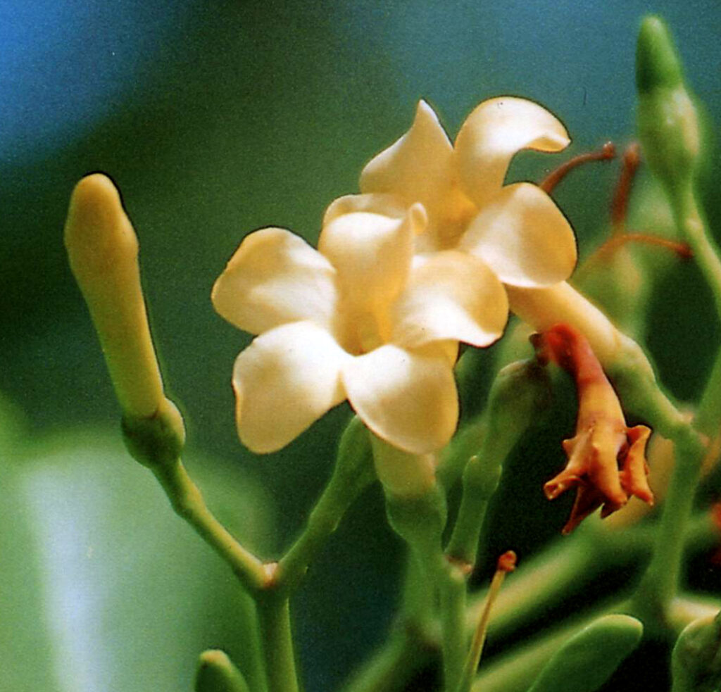
Puakenikeni

In Mangaian, the pua tree was the tree that guarded the entrance to the land of the spirits in the underworld (Mangaia, traditionally known as Aʻuaʻu Enua (which means terraced) is the most southerly of the Cook Islands.)    (Neal, Agroforestry)

In Tahitian legend, the first pua tree was brought from the tenth heaven by Tane, god of the forests.  Hence the tree is sacred to him, and the images of him were always made of pua wood.  (Neal, Agroforestry)

Indigenous from New Guinea and Northern Australia, to the Marianas and eastward to the Caroline Islands (east of the Marquesas,) it is a shrub or small tree (Fagraea berteriana) grown ornamentally for foliage, flowers and fruit.

Its original Polynesian name was simply “pua” which is still used over most of its native range in Polynesia and is a cognate of the Fijian name. The tree was considered sacred in the Cooks and Tahiti in ancient times. Concoction of the inner bark was used in treating asthma and diabetes.  (Whistler)

It is grown in most Polynesian countries like Tonga, Niue, Uvea, Societies, Cooks, Australs, Mangareva, Marquesas, Samoa (pua lulu.)

In Hawaiʻi, it is called puakenikeni.

Approximately 9,000 new species of flowering plants were introduced to Hawaiʻi from all over the world during the over two centuries since ‘Contact’ (1778.)

Some, including puakenikeni (as well as plumeria, carnation, ginger, pīkake, pakalana and pua male (Stephanotis,)) quickly became favorites of island residents and staples of the lei industry.  (CTAHR)

Lei makers down on the Honolulu docks selling lei during the “Steamer Days” or “Boat Days” (late-1800s to mid-1900s) would string the puakenikeni into fragrant lei.

It earned its name Pua Kenikeni (Puakenikeni) here in Hawaiʻi because at one time the flowers were sold for making lei, each flower (“pua”) cost a dime (kenikeni means dime, ten cents,) hence the name “ten-cent flower.”  (Pukui, Neal, Agroforestry)

“500 persons in Honolulu make a living wholly or partly by selling leis – those fragrant garlands of pikake, ginger blossoms, gardenias, tube roses, carnations and a score of other flowers – which are dangled about the neck upon any excuse from a sailing to a dinner table.”  (The Sunday Morning, June 6, 1937)

Flowers are best harvested 2-3 times per week in early morning.  Open white flowers can be stored at room temperature for up to 3-days.

While most lei do well in dry plastic bags kept in the refrigerator, the exception is puakenikeni which turns brown if refrigerated.  Instead, keep it between damp paper towels in a flat container set in a cool, dark place.

It is one of the few flowers that has three different colors as it ages (with the same scent throughout.)  The first day it’s creamy white, by the second it’s at buttery yellow and on the third it’s a creamy orange.

Lei Pua Kenikeni – Written by John Kameaaloha Almeida (1897-1985)
(Translated by Mary Pukui)

(Click HERE for rendition of Puakenikeni performed by Mark Yamanaka)

No ka lei aloha, lei pua kenikeni
Koʻu hiaʻai a me koʻu hoʻohihi

Ke ʻala hoʻoheno kaʻu aloha
I ka ne mai e welilna kaua

Kaua i ka nani a o ia pua
I ka hana hoʻoipo a ke onaona

Onaona lei nani lei hoʻohie
Hoʻoipo, hoʻoulu mahiehie

Mapu ʻala hoʻoheno i ka poli
Lanikeha i ka ike a ka maka

Eia no ka puana o ke mele
No ka lei pua kenikeni he inoa

For the beloved lei of pua kenikeni
My admiration and delight

Its pleasing perfume I enjoy
Which tells our love for each other

May you and I admire the flowerʻs beauty
With its subtle fragrance so appealing

Fragrant, beautiful and excellent is the lei
Appealing and most attractive

Its soft perfume wins the heart
Its beauty is most entrancing

This is the ending of this song
In praise of the pua kenikeni

© 2022 Hoʻokuleana LLC

Filed Under: Economy, General Tagged With: Hawaii, Honolulu Harbor, Puakenikeni

February 26, 2022 by Peter T Young Leave a Comment

Trouble On The Waterfront (HHR Revival)

Shortly before nine o’ clock on the morning of Thursday, November 10, 1853, knots of weather beaten men hurried along the streets and alleys of Honolulu’ waterfront.

They were masters of whalers and merchantmen riding out in the harbor. Their destination: the new court house on Queen Street. Their purpose: to set pay scales for sailors and dock workers.

Inside the court house Captain Israel West took the chair, and the discussion began. The skippers hammered out a resolution:

Whereas, in the opinion of the ship masters at this port a uniform price to be paid f or wages of laborers by ship masters in this harbor, and of lays and wages from this port, would be of equal advantage to laborers, owners, and shipmasters. …

Therefore, merchants and shipmasters should establish:
(1) a standard wage of $1 .50 found, and $2 .25 for those keeping themselves, for a day’s labor of ten hours;
(2) a standard rate of $12.00 a month for sailors shipping for monthly wages, either on a short season’s cruising or on a return home passage;
(3) a limit of $25.00 for any and all advances to seamen, and
(4) a rule that shipmasters not pay crews for discharging vessels in Honolulu.

This was the captains’ answer to seamen and Hawaiian laborers, who were pressing for more pay. On the night of Saturday the twelfth the seamen held their meeting.

The result was that on Monday morning they were “… early in commotion about the wharves …” – striking.

The strikers boarded one or two vessels where men continued to work and drove them from their jobs.

In the afternoon more than 1,000 sailors paraded the streets with fife and drum. Many native laborers joined them, but by Wednesday most of these had agreed to work f or the $1.50 offered.

Some of the seamen tried to stop them, but they could not get solid backing from their shipmates.

This doomed the strike.

Honolulu police were ab le to protect the workers. Most of the strikers held out, and seemed likely to do so until they had spent all their money – a short process, in the US Commissioner’s view He predicted that “… the grog shops and the native women will soon empty their pockets.”

And such, apparently, proved to be the case.

But the strike may not have been fruitless. At the end of the month sailors’ wages in merchant vessels were $25.00 monthly, and laborers’ hire ran from $2.00 to $3.00 a day.

Gains came hard in the Honolulu of 1853, however.

The great smallpox epidemic stagnated retail business. Sailors were in plentiful supply. And organized labor was a thing of the future.

The above is all from Richard Greer’s article on the 1853 strike at Honolulu Harbor for more pay to sailors (Trouble on the Waterfront) in the April 1963 Hawaiian Historical Review.

This is only a summary; click the following link to get to Greer’s initial article:
https://imagesofoldhawaii.com/wp-content/uploads/Trouble-on-the-Waterfront-HHR-Revival-Greer.pdf

© 2022 Hoʻokuleana LLC

Filed Under: Sailing, Shipping & Shipwrecks, Economy Tagged With: Hawaii, Honolulu Harbor, 1853 Sailors' Strike

September 30, 2021 by Peter T Young 5 Comments

Brothers Continue The Legacy

For much of the 1800s, sailing ships calling at Honolulu Harbor were serviced using double-hulled canoes or rowboats.
In 1900, three brothers, Jack, Herbert and William, formed Young Brothers and started doing small jobs around the Harbor.
Early in the century, there was only a narrow opening in the reef, so sailing ships anchored outside where they had room to maneuver. They then came ashore in their own boats or used launch services from the harbor.
Jack Young once reminisced about arriving in Honolulu in 1900 with a few cans of fruit, a large trunk and only twenty-five cents in cash – too little to pay to have his trunk brought ashore. So he rustled up a spare rowboat and rowed in his own gear.
In those days, there might be from five to twenty sailing ships off Sand Island. When a ship came in, the anchor line had to be run out to secure the ship; if the ship was coming to the dock, a line had to be carried to the pier.
In the early years of the company, Young Brothers used its first boat, Billy, to service the ships by carrying supplies and sailors to ships at anchor outside the harbor, as well as run lines for anchoring or docking vessels.
They also pulled boats off the reefs, conducted salvage operations and various other harbor-related activities (including harbor tours.)
The company grew over the years into an active interisland freight company.
When original brother Jack’s two sons became old enough, they joined the operation.
Jack Young Jr., joined the company as a regular employee in 1933. He soon captained various boats; in 1936 he became the permanent master of the Mamo (which in 1930 was the first all-steel tugboat in maritime history.)
Jack’s younger brother, Kenny Young, joined Young Brothers in 1946, after a stint in the Navy and graduation from Stanford.
He immediately became superintendent of Young Brothers’ freight department, a position he held until 1952. That same year, Young Brothers merged with Oahu Railway and Land Company (OR&L.)
Jack Jr. resigned from Young Brothers in 1952 (having disagreed with the merger and its resulting changes in management policies.)
However, Jack Jr. continued to broaden his maritime skills, earning a Master Maritime license and becoming a Harbor Pilot for the Territory of Hawai‘i, then Harbor Master for the State. (Jack Jr. passed away in 1994.)
Kenny remained with the company after the merger and served as manager of the land department of OR&L (1952-1961.)
When OR&L merged with Dillingham Corporation, he was manager and vice president at Dillingham until 1968.
He then moved to Kona and started his own real estate company. (Kenny passed away in 2004.)
Jack Young of the original Young Brothers is my grandfather; Jack Young Jr, my uncle; and Kenny Young, my father.
The Young family legacy at Young Brothers continued; for a while, my older brother, David Young, served as a Hawai‘i County Community Advisory Board Member for the Young Brothers Community Gift Giving program.
I am the youngest brother of the youngest brother of the youngest brother of Young Brothers.
© 2021 Hoʻokuleana LLC

Jack Edgar and Will Young 1903
Young_Brothers-first_boat-Billy
Young-Brothers-Captain_Jack_Young_(grandfather)_on_Makaala
Kenny Young
Kenny Young
Da_Braddahs
Young_Brothers-Fleet-1915
Young_Brothers_Boathouse-center_structure_with_open_house_for_boats_on_its_left-1910
Young Brothers Launch 'Sea Scout' in Honolulu Harbor-Lucas_Tower_in_background-PPWD-9-3-030-1905-400
Young Brothers Launch ‘Sea Scout’ in Honolulu Harbor-Lucas_Tower_in_background-PPWD-9-3-030-1905-400
Young_Brothers_Boathouse-1902
Young Brothers shark hunt
Kapena Jack Young Drawing
IMG_2905
IMG_7931

Filed Under: Prominent People, Economy, Sailing, Shipping & Shipwrecks Tagged With: Kenny Young, Images of Old Hawaii, Captain Jack, Hawaii, Jack Young, Young Brothers, Honolulu Harbor, Oahu Railway and Land Company, Dillingham

May 22, 2020 by Peter T Young 3 Comments

Evolution of Honolulu Harbor

Coral doesn’t grow in freshwater. So, where a stream enters a coastal area, there is typically no coral growth at that point – and, as the freshwater runs out into the ocean, a coral-less channel is created.

In its natural state, thanks to Nuʻuanu Stream, Honolulu Harbor originally was a deep embayment formed by the outflow of Nuʻuanu Stream creating an opening in the shallow coral reef along the south shore of Oʻahu.

Honolulu Harbor (it was earlier known as Kuloloia) was entered by the first foreigner, Captain William Brown of the English ship Butterworth, in 1794.

They called the harbor “Fair Haven” which may be a rough translation of the Hawaiian name Honolulu (it was also sometimes called Brown’s Harbor.) The name Honolulu (meaning “sheltered bay” – with numerous variations in spelling) soon came into use.

Tradewinds blow from the Northeast; the channel into Honolulu Harbor has a northeasterly alignment. Early ships calling to Honolulu were powered only by sails. The entrance to the harbor was narrow and lined on either side with reefs. Ships don’t sail into the wind. Given all of this, Honolulu Harbor was difficult to enter.

Boats either anchored off-shore, or they were pulled into the harbor (this was done with canoes; or, it meant men and/or oxen pulled them in.)

It might take eight double canoes with 16-20 men each, working in the pre-dawn calm when winds and currents were slow. In 1816 (as stories suggest,) Richards Street alignment was the straight path used by groups of men, and later oxen, to pull ships through the narrow channel into the harbor. (Richards Street was named for a man selling luggage to tourists in his shop on that street.)

A few years after, in 1825, the first pier in the harbor was improvised by sinking a ship’s hull near the present Pier 12 site. As Honolulu developed and grew, lots of changes happened, including along its waterfront. What is now known as Queen Street used to be the water’s edge.

The first efforts to deepen Honolulu Harbor were made in the 1840s. The idea to use the dredged material, composed of sand and crushed coral, to fill in low-lying lands was quickly adopted.

In 1854 the first steam tug was used to pull sail-powered ships into dock against the prevailing tradewinds.

The old prison was built in 1856-57 at Iwilei; it took the place of the old Fort Kekuanohu (that also previously served as a prison.) The new custom-house was completed in 1860. The water-works were much enlarged, and a system of pipes laid down in 1861.

Between 1857 and 1870, the coral block walls of the dismantled Fort edged and filled about 22-acres of reef and tideland, forming the “Esplanade” or “Ainahou,” between Fort and Merchant Streets (where Aloha Tower is now located.) At that time, the harbor was dredged to a depth from 20 to 25-feet took place.

By the 1880s, filling-in of the mud flats, marshes and salt ponds in the Kakaʻako and Kewalo areas had begun. This filling-in was pushed by three separate but overlapping improvement justifications.

The first directive or justification was for the construction of new roads and the improvement of older roads by raising the grade so the improvements would not be washed away by flooding during heavy rains.

Although public health and safety were prominently cited as the main desire (and third justification) to fill in Honolulu, Kewalo, and then Waikīkī lands, the fill ultimately provided more room for residential subdivisions, industrial areas and finally tourist resorts.

In the early part of the twentieth century, Kakaʻako was becoming a prime spot for large industrial complexes, such as iron works, lumber yards, and hauling companies, which needed large spaces for their stables, feed lots and wagon sheds.

An 1887 Hawaiian Government Survey map of Honolulu shows continued urban expansion of the Downtown Honolulu area.

In 1889, the Honolulu Harbor was described as “nothing but a channel kept open by the flow of the Nuʻuanu River;” a sand bar restricted entry of the larger ocean vessels. In 1890-92, a channel 200-feet wide by 30-feet deep was dredged for about 1,000-feet through the sand bar.

Piers were constructed at the base of Richards Street in 1896, at the site of Piers 17 and 18 in 1901 to accommodate sugar loading and at Piers 7 and 12 in 1907.

After annexation in 1898, the harbor was dredged using US federal funds. The dredged material was used to create a small island in the harbor in order to calm the harbor and avoid constructing a breakwater. This island became what is now known as Sand Island.

In 1904, the area around South Street from King to Queen Streets was filled in. The Hawaiʻi Department of Public Works reported that “considerable filling (was) required” for the extension of Queen Street, from South Street to Ward Avenue, which would “greatly relieve the district of Kewalo in the wet season.”

A series of new piers were constructed at the base of Richards Street in 1896, at the site of Piers 17 and 18 in 1901 (to accommodate sugar loading) and then at Piers 7 and 12 in 1907. Further dredging was conducted at the base of Alakea Street in 1906.

With the opening of the Panama Canal in 1914 and anticipated increased trans-Pacific shipping, government and business planned to further enlarge Honolulu Harbor by dredging Kalihi Channel and Kapālama Basin.

However, because of military concerns, the Reserved Channel connecting Honolulu Harbor to Kapālama Basin was dredged instead. This is known as the Kapālama Channel. Honolulu Harbor expanded into the Kapālama Basin and by the early 1930s Piers 34 had been constructed. Pier 35 was constructed in 1931 to provide dedicated facilities for inter-island pineapple shipments.

On September 11, 1926, after five years of construction, Aloha Tower was officially dedicated at Pier 9; at the time, the tallest building in Hawaiʻi.

Today, Honolulu Harbor continues to serve as Hawai‘i’s commercial lifeline for goods to/from Hawaiʻi and the rest of the world.

The image shows Honolulu in 1854, in a drawing done by Paul Emmert. It shows Honolulu just before these changes and the expansion of land in the downtown area (you can see people standing on the reef on the right.)

Follow Peter T Young on Facebook 

Follow Peter T Young on Google+ 

Follow Peter T Young on LinkedIn  

Follow Peter T Young on Blogger

© 2020 Hoʻokuleana LLC

'Port_of_Honolulu'_by_Louis_Choris-1816
‘Port_of_Honolulu’_by_Louis_Choris-1816
'HONOL~1
Port_of_Honolulu-1816-1817
Honolulu_Fort_(PP-36-5-001)-1837
Interior_of_the_Fort,_Honolulu_Harbor-1830s-1840s
Honolulu Harbor-Ships pulled by canoes-Henry Walker-1843
Battle_of_Honolulu-Dolphin-(Massey)-1826
View_of_Honolulu_Harbor_and_Punchbowl_Crater._(c._1854)
Downtown_Honolulu-sites-uses_noted-(1870_roads_in_red)-Map-1810
'Entrance_to_Honolulu_Harbor'-William_Alexander_Coulter-1882
Fort Armstrong-1910
Honolulu Harbor Map - 2012
Honolulu_from_Punchbowl_1890
Honolulu_Harbor_(taken_from_prison_in_Iwilei)
Honolulu_Harbor_in_1810
Honolulu_Harbor_in_1881
Honolulu_Harbor_Kotzebue-Map-1816
Honolulu_Harbor-Downtown-(DAGS0237)-early-1850s
Honolulu_Harbor-InteriorDept-(Wall-Reg_1119)-1886
Honolulu_Harbor-Tall_Ships-1889
Honolulu_Map-(1810)-over_GoogleEarth
Honolulu_Map-(1843)-over_GoogleEarth
Honolulu_Map-(1847)-over_GoogleEarth
Honolulu_reproduced_from_map_drawn_by_Lt_CR_Malden_of_HBMS_Blonde-1825
Honolulu_waterfront,_c._1890
IMG_1159
IMG_1161
IMG_1165
IMG_1588
Map Detail of Honolulu Harbor-C. R. Malden_Reg640 (1825)

Filed Under: General, Sailing, Shipping & Shipwrecks, Economy Tagged With: Honolulu Harbor, Nuuanu, Aloha Tower, Hawaii, Panama Canal, Honolulu, Oahu, Downtown Honolulu, Fort Kekuanohu, Kewalo, Kakaako, Esplanade

May 20, 2020 by Peter T Young Leave a Comment

Immigration Station

By the middle of the 19th century the Hawaiian population had declined drastically through the impacts of disease and epidemics and the dispersal of the young men of the Kingdom on whaling ships and seeking their fortunes in the California gold fields.

In 1850, the Hawaiian population was down to 46,500. At the same time the American occupation of California and Oregon gave the islands a large, relatively close market for agricultural crops.

Starting in the 1850s, when the Hawaiian Legislature passed “An Act for the Governance of Masters and Servants,” a section of which provided the legal basis for contract-labor system, labor shortages were eased by bringing in contract workers from Asia, Europe and North America.

In 1852, the first group of 200 Chinese labor contract immigrants were brought in to work in the sugar plantations. In the hundred years from 1850 to 1950, over 350,000 labor immigrants were brought in to supply workers for the plantations and to augment a declining population with people of kindred races.

For nearly one hundred years immigrants arriving in Hawaiʻi had their initial processing in the area of the present immigration building at the entrance to Honolulu Harbor.

In the 19th century they came over the channel wharf to be processed at the pavilion and quarters of the Kingdom’s Quarantine and Immigration Depot built in 1879 on what was popularly called Fisherman’s Point.

King Kalākaua, who personally initiated Japanese immigration in a visit to the Emperor, visited the station to greet the initial group of Japanese laborers arriving in 1886. After a hospitable welcome which included entertainment of hula dancers, he invited some of the group to the Palace to display their skill at fencing. (NPS)

The United States government took over immigration matters after annexation and built new structures out over the mud flats (which opened July 4, 1905.)

The buildings were designed to fit the climate and atmosphere of Hawaiʻi and to be an inviting place for immigrants to come through. (This was the first use of terra cotta in Hawaiʻi.)

Although Herbert C. Clayton was the architect who contracted to design the building, it is quite evident that the architect associated with him for this project had the major design role, CW Dickey.

The entrance portico designed by Dickey as the most important architectural feature of the building reflects Hawaiʻi and the Immigration Station function as a bridge between East and West.

The portico is accented by Chinese architectural details and the large bronze compass plaque set in the floor of the entrance lobby shows Hawaiʻi as the crossroads of the Pacific by indicating distances to principle cities on the Pacific rim.

An interview with Mr. Dickey on July 27, 1934 in the Honolulu Star-Bulletin best describes the intent and execution of the complex in the designer’s own words:

“In designing the new immigration station buildings the main objective was a group of buildings expressing the spirit and environment of Hawaiʻi and at the same time maintaining well balanced and well-proportioned masses, graceful lines and a pleasing color effect.”

“This meant a wide departure from the more or less stereotyped stations of the mainland and it required no small amount of persuasion and diplomacy to get such a design accepted….”

“In general the buildings consist of low lying masses of cream colored stucco walls surmounted by graceful sloping roofs of variegated green and russet tiles.”

A special area was designed into the building to provide a “matrimonial” room where Japanese girls, who had been married by proxy in Japan to men living in Hawaiʻi, met their husbands for the first time and were formally married. These picture brides numbered 14,276 between the years 1907 and 1923.

Mr. AE Burnett, for many years the District Director of Immigration, hoped that the buildings would serve as a model for other stations across the nation.

The Dickey designed buildings were placed on the National Register of Historic Places (much of the information here came from those records.)

(By the way, in the existing immigration center, there is a fountain put in by Italian POWs from WWII – unfortunately, it is in a secured area and you can’t get directly to it. However, you can see it through a chain link fence on the back side (makai) of the building.)

Follow Peter T Young on Facebook 

Follow Peter T Young on Google+ 

Follow Peter T Young on LinkedIn  

Follow Peter T Young on Blogger

© 2020 Hoʻokuleana LLC

Arrival of Japanese contract laborers at Honolulu Harbor-1893
US-immigration-station-Honolulu-(HSA-S00042)-1905
US-immigration-station-Honolulu-(eBay)
Fort Armstrong-Immigrations_Station-behind-1910
Japanese immigrants landing at Honolulu Harbor-1893
Chinese_contract_laborers_on_a_sugar_plantation_in_19th_century_Hawaii-(WC)
Filipino_immigrant_family_in_Hawaii,_c._1906
Japanese_Picture_Bride
Kalakaua_in_Japan_(1881)
Korean_immigrant_family_in_Hawaii_during_the_19th_century
Portuguese_immigrant_family_in_Hawaii_during_the_19th_century-(WC)
Statue erected on the 100th anniversary of the 1st Japanese immigration to Hawaii-1885-Kepaniwai Heritage Gardens, Iao Valley
Hawaii_Sources_of_Immigration-1853-1933
Japanese_Picture_Brides-Desert_News-July_8,_1922
US-immigration-station-Honolulu-(PBN)
OLYMPUS DIGITAL CAMERA

Filed Under: Economy, General, Sailing, Shipping & Shipwrecks Tagged With: Dickey, Immigration Station, Hawaii, Oahu, Honolulu Harbor

  • « Previous Page
  • 1
  • …
  • 3
  • 4
  • 5
  • 6
  • 7
  • …
  • 9
  • Next Page »

Images of Old Hawaiʻi

People, places, and events in Hawaiʻi’s past come alive through text and media in “Images of Old Hawaiʻi.” These posts are informal historic summaries presented for personal, non-commercial, and educational purposes.

Info@Hookuleana.com

Connect with Us

  • Email
  • Facebook
  • LinkedIn
  • Twitter
  • YouTube

Recent Posts

  • Papa Koa Lumber Company
  • About 250 Years Ago … Battles of Saratoga
  • ‘A Swarm of B’s Has Come’
  • About 250 Years Ago … US Constitution
  • Hiram Bingham: I – IV
  • Haui ka Lani
  • Niuhelewai

Categories

  • Schools
  • Sailing, Shipping & Shipwrecks
  • Economy
  • Voyage of the Thaddeus
  • Mayflower Summaries
  • American Revolution
  • General
  • Ali'i / Chiefs / Governance
  • Buildings
  • Missionaries / Churches / Religious Buildings
  • Hawaiian Traditions
  • Military
  • Place Names
  • Prominent People

Tags

Albatross Al Capone Ane Keohokalole Archibald Campbell Bernice Pauahi Bishop Charles Reed Bishop Downtown Honolulu Eruption Founder's Day George Patton Great Wall of Kuakini Green Sea Turtle Hawaii Hawaii Island Hermes Hilo Holoikauaua Honolulu Isaac Davis James Robinson Kamae Kamaeokalani Kameeiamoku Kamehameha Schools Lalani Village Lava Flow Lelia Byrd Liberty Ship Liliuokalani Mao Math Mauna Loa Midway Monk Seal Northwestern Hawaiian Islands Oahu Papahanaumokuakea Marine National Monument Pearl Pualani Mossman Quartette Thomas Jaggar Volcano Waikiki Wake Wisdom

Hoʻokuleana LLC

Hoʻokuleana LLC is a Planning and Consulting firm assisting property owners with Land Use Planning efforts, including Environmental Review, Entitlement Process, Permitting, Community Outreach, etc. We are uniquely positioned to assist you in a variety of needs.

Info@Hookuleana.com

Copyright © 2012-2024 Peter T Young, Hoʻokuleana LLC

Loading Comments...