Images of Old Hawaiʻi

  • Home
  • About
  • Categories
    • Ali’i / Chiefs / Governance
    • American Protestant Mission
    • Buildings
    • Collections
    • Economy
    • Missionaries / Churches / Religious Buildings
    • General
    • Hawaiian Traditions
    • Other Summaries
    • Mayflower Summaries
    • Mayflower Full Summaries
    • Military
    • Place Names
    • Prominent People
    • Schools
    • Sailing, Shipping & Shipwrecks
    • Voyage of the Thaddeus
  • Collections
  • Contact
  • Follow

May 23, 2023 by Peter T Young Leave a Comment

Naukane

During Captain Cookʻs visit to Hawaiʻi on his third voyage of exploration in 1779, then-Lieutenant King (later Captain) noted, “During the following night, the cutter belonging to the Discovery was stolen …”

“This irritated captain Cook, and he gave orders to stop all the canoes that should attempt to leave the bay, intending to seize and destroy them, if he could not recover the cutter by fair means.”  (Captain King’s Journal)

“The natives now collected in vast numbers along the shore, and began to throng round captain Cook”.  Shortly after, “Captain Cook, the last time he was seen distinctly, was standing at the water’s edge”.

“… he was desirous of preventing any farther bloodshed … whilst he faced the natives, none of them had offered him any violence, but having turned about to give his orders to those in the boats, he was stabbed in the back”.  Cook was killed.    (Captain King’s Journal)

One of the Hawaiians at the scene was Naukane, son of Kamanawa (Kamehameha’s uncle and one of his closest allies – Kamanawa (left) and Kameʻeiamoku, his twin brother (right) were later memorialized on the Hawaiʻi coat of arms.)  (Kittelson)

When Kamehameha moved his Royal Center to Honolulu, his chiefs came with him. Naukane, then in his early twenties, accompanied his father and probably became involved in royal court life.  However, fascinated by the growing number of ships calling in the islands, Naukane looked to the sea. (Kittelson)

His chance came in February 1811, when John Jacob Astor’s ‘Tonquin,’ under the command of Captain Jonathan Thorne, called.  The captain wanted to hire twenty-four of the Islanders, twelve as seamen and the remaining half to establish a post for the Pacific Fur Company on the Columbia River.

This was the first large group of Hawaiians to come to America.  The king appointed Naukane to go with them as a royal observer.  (Duncan)

Because Naukane resembled one of the Americans, he became known as John Coxe and retained the name throughout his long and colorful life in the Pacific Northwest (he also went by John Cox and Edward Coxe, or, simply Coxe.)  (Duncan)

The Tonquin reached the mouth of the Columbia in March; after a few days looking, they selected a site and by the end of May they had completed Fort Astoria.  It was the first American-owned settlement on the Pacific coast of what was to become the United States.

Astor planned the post to grow into a permanent settlement, with plans to develop a large trade ring that included New York, the Pacific Coast, Russian Alaska, Hawaiʻi and China. The furs collected in the northwest and Alaska, would be shipped to China and exchanged for porcelain, silk and other cloth, and spices that would be brought back, via Hawaii to New York.

Other operators had other posts.  In the summer of 1810, Jacques-Raphaël Finlay (Jaco Finley) of the North West Company built Spokane House at the junction of the Spokane and Little Spokane rivers.

Shortly after arriving in the northwest, Coxe started working for Canadian David Thompson of the North West Company.   Coxe later spent the winter of 1811-1812 at Spokane House with Finlay.  On those expeditions, Coxe became the first Hawaiian to visit the inland Northwest.

Coxe accompanied Thompson “across the Rocky Mountains from western Montana and in the long trail to Fort William on Lake Superior. … John Coxe also took the trail east from Fort William but his road led to Quebec, where he created a sensation with his stories of Hawaiʻi and his demonstrations of Polynesian dance steps.”  (Taylor)

By 1813, Fort Astoria and all other assets in the area were sold to the North West Company – they renamed it Fort George.    Coxe continued to work there until August, 1814, when all of the Hawaiians at Fort George were sent back to the Islands.

Comfortable with the service from the Hawaiians, in 1817, North West sent a ship “to bring as many of the Sandwich Islanders to the Columbia river as we could conveniently accommodate.”  (Corney)

(In 1821, the Hudson’s Bay Company combined with the North West Company, and the post name was changed back to Fort Spokane.)

After he returned to Honolulu in 1815, Coxe probably reverted to his native name, Naukane.  He was well received by Kamehameha.

Not only was Naukane the son of one of Kamehameha’s closest advisors, and a member of Liholiho’s entourage, but he had traveled widely. Kamehameha I died in 1819 and Naukane rose in stature when Liholiho ascended the throne.  (Kittelson)

Naukane’s expeditions did not end on the American continent.  Because of his familiarity with western ways (with travels to America, Europe & South America) and his personal ties, when Liholiho departed on November 27, 1823 to England aboard the L’Aigle to discuss the future of his Islands with George IV, Naukane accompanied the King.

The King Kamehameha II and Queen Kamāmalu died of measles in July 1824; apparently Naukane’s travels had built up his immunity, for he was hardly bothered by measles.

King George IV held an audience for the remaining Hawaiians at Windsor Castle on September 11; Coxe was present.  The bodies of Liholiho and his queen were returned to Hawaii aboard the frigate Blonde captained by Lord Byron.

With the King dead, Naukane no longer was bound, and he immediately offered his services to the Hudson’s Bay Company and returned to the Northwest. He was only one of approximately thirty-five Islanders working for the company by 1825.  (Duncan)

The firm’s base of operations had been transferred from Fort Spokane to a new site farther inland, Fort Vancouver. Coxe worked for a few more years; then the company retired him and gave him a plot of land two miles below the fort.  (Kittelson)

Naukane died February 2, 1850.  The vast plain between Fort Vancouver and the Columbia became the Hawaiian’s memorial – Coxe’s Plain … “A couple of miles below the fort (Vancouver) there were luxuriant meadows of great extent.”

“A portion of these bore at that time the name of Coxe’s Plain, a name I think which it still continues to bear. Old Coxe, a native of the Sandwich Islands and a very original character, was the swine-herd and had his residence there among the oaks which dotted the verge of the plain.”  (Anderson; Barry)

© 2023 Hoʻokuleana LLC

Filed Under: Economy, Prominent People Tagged With: Naukane, Hawaii, John Coxe, Kamanawa, Captain Cook, Kamehameha, Liholiho, Fort Vancouver, Fort William, Kamamalu, Fort Astoria, Spokane House

May 22, 2023 by Peter T Young Leave a Comment

Hualalai

When the American Protestant missionaries arrived in the Islands (1820), they sailed from Kawaihae to Kailua-Kona; Bingham wrote, “As we coasted slowly along southward, we had a grand view of Hualalai, the volcanic mountain that rises some eight or nine thousand feet, near the western side of Hawaii, with its terminal crater, its forests, and apparently recent streams of lava.”

In Kona, the “village of thatched huts, though in a dry and sterile spot, is ornamented with cocoanut and Kou trees, which to the eye form a relief. A few miles inland, trees and plantations are numerous; then, still further back, rises the forest-covered Mauna Hualalai, with its lofty terminal crater, now extinct. . .”

Missionary wife, Lucy Thurston noted, “On the mountain Hualalai, just back of Kailua, is a large crater. It is now extinct. But our old people tell us of the time in their childhood, when they were aroused from their midnight slumbers, to see red hot balls hurled into the air from out the crater on this mountain.”

“Torrents of molten lava flowed from crater to coast, extended the shore farther out into the sea, and encrusted the surface of the earth, besides leaving an abundance of large loose scoriae, tossed about in every direction.”

Hualalai (“obstructing the flow” (Parker Dictionary for a crater on the mountain)) is the third youngest and third-most historically active volcano on the Island of Hawai‘i.

Six different vents erupted lava between the late 1700s and 1801, two of which generated lava flows that poured into the sea on the west coast of the island. The Keāhole Airport is built atop the larger flow.  (USGS)

The 1801 flow covered Pā‘aiea pond; “Pā‘aiea was a great pond almost like the ponds of Wainanalii and Kiholo. In the olden days, when the great ruling chiefs were living, and when these fish ponds were full of the riches of Awa, Anae, and Ahole, along with all sorts of fish which swam within.”

“During that time, Konohiki were stationed, and he was the guard of the pond that watched over the pond and all things, as here we are talking about Pā‘aiea Pond which was destroyed by lava and became pahoehoe lava which remains today”.

“In the correct and trues story of this pond, its boundaries began from Kaelehuluhulu on the north and on the south was at the place called Wawaloli, and the distance from one end to the other was 3 miles or more, and that was the length of this pond …”

“… and today within these boundaries, there are a number of pools [lua wai loko] remaining during this time that the writer is speaking before the readers of the Hoku.”  (Hoku o Hawaii, 2/5/1914)

The lava came and destroyed the great fishpond of Pā‘aiea, dried its water and filled and covered it with black rocks.  However, two places were spared.

There remained only that very small portion of the fishpond, close to Ho‘ona (within the Natural Energy Laboratory property at Keāhole Point.)  Also, the area below the old headquarters at Hu‘ehu‘e Ranch was left untouched, and this open space bears the name of Pahinahina to this day.

It is said that because of this event that the lands of Manuahi came to be called Ka-ulu-pulehu (the roasted breadfruit (‘ū is short for ‘ulu,)) and this has been shortened to Ka‘ūpūlehu.

Though Hualalai is not nearly as active as Mauna Loa or Kilauea, recent geologic mapping of the volcano shows that 80 percent of Hualalai’s surface has been covered by lava flows in the past 5,000 years.  (USGS)

In the past few decades, when most of the resorts, homes and commercial buildings were built on the flanks of Hualalai, earthquake activity beneath the volcano has been low.

In 1929, however, an intense swarm of earthquakes lasting more than a month was most likely caused by magma rising to near the surface. For these reasons, Hualalai is considered a potentially dangerous volcano that is likely to erupt again in the next 100 years.  (USGS)

A Pālama Nui kāua
Wai māpuna kau i ka maka ka ‘ōpua
Hualalai huewai kuahiwi

You and I stand together on the Foundation of Profound Enlightenment
Where the spring water is borne upon the clouds
Mount Hualalai, a mountain water-gourd

(from Nā‘ū Pālama Nui – ”Hualalai, huewai kuahiwi” is a traditional saying honoring Hualalai’s role in sponging the atmosphere of moisture to fill the aquifers.) (Tangarō, UH-HCC)

With respect to groundwater, an interesting conclusion, based on isotopic data for the high level water, shows that most of the groundwater recharge under Hualalai is coming from recharge at significantly higher elevations than the local rainfall in the mid-elevations of Hualalai (at nearly 3,000 year average age of the water in the high level aquifer).

In other words, not much of the “local” rainfall in the vicinity of the high level wells is actually getting into the high level aquifer. (as noted by Don Thomas, research faculty of the Hawai‘i Institute of Geophysics and Planetology at UH and Director of the Center for the Study of Active Volcanoes at the UH‐Hilo campus.)

The only alternative that can explain the isotopic and age data for the high level aquifer, with significant amounts of local recharge entering it, is that substantially larger amounts of much older recharge to the high level aquifers is coming into the Hualalai water system from the adjacent regions in the Saddle and from Mauna Loa.  (Don Thomas)

© 2023 Ho‘okuleana LLC

Filed Under: Hawaiian Traditions, Place Names Tagged With: Hawaii Island, Paaiea, Hualalai, Hawaii

May 21, 2023 by Peter T Young Leave a Comment

West Loch Tragedy

Despite its moniker, “Large Slow Target,” the ‘Landing Ship, Tank’ (LST) was an important naval vessel created during World War II to support amphibious operations by carrying significant quantities of vehicles, cargo and landing troops directly onto an unimproved shore.

An LST, 382-feet long and 50-feet wide, carried a crew of 8-10 officers and 115 enlisted men; in addition, there were berths for over 200-troops and a capacity to carry a 2,100-ton load of tanks, trucks, jeeps and weapon carriers and associated munitions and supplies.

1,051 LSTs were constructed and used in the war effort; they were used in the Atlantic and the Pacific.  Only 26 were lost in WWII due to enemy action.

However, in Hawaiʻi, a once secret and often-forgotten tragedy struck at Pearl Harbor, in 1944.

At the time, the Allied forces were preparing for two assaults – one was in the Atlantic (D-Day, June 6, 1944 – nearly 200,000-Allied troops on 7,000-ships and more than 3,000-aircraft headed toward Normandy, France.)

The other was in the Pacific (Saipan, June 15, 1944 – more than 300-landing vehicles put 8,000-Marines on the west coast of Saipan; eleven support ships covered the Marine landings.)

In preparation for the Saipan assault, in late-May, crews were loading ships at the US Pacific Fleet base at West Loch, Pearl Harbor.

(Pearl Harbor is divided into a series of lochs that fan out from Ford Island that sits in the center of harbor. West Loch was the staging area for the invasion fleets of the Pacific.)

29-LSTs, plus a variety of other amphibious vessels that would support the initial landings and follow-on operations, were tightly clustered while their hulls and decks were being filled with ammunition, supplies and other material.

That list of items included munitions of all calibers and types, propellants, aviation gasoline, vehicle fuel and a variety of other volatile cargoes.

Nested beam-to-beam at piers off of Hanaloa and Intrepid Points opposite Lualualei (now known as Naval Magazine Pearl Harbor) were six compact rows of LSTs and other craft moored at “Tare” piers jutting into the adjoining waters of West Loch and Walker Bay.

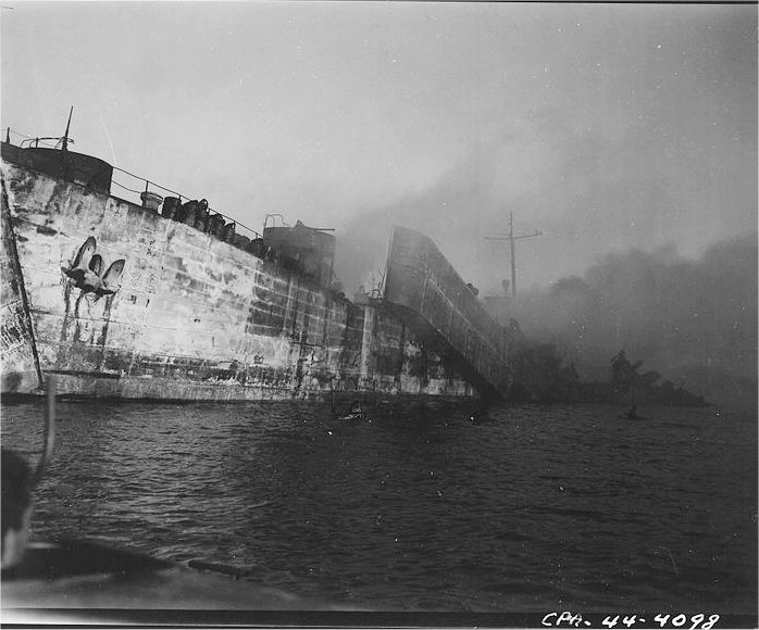
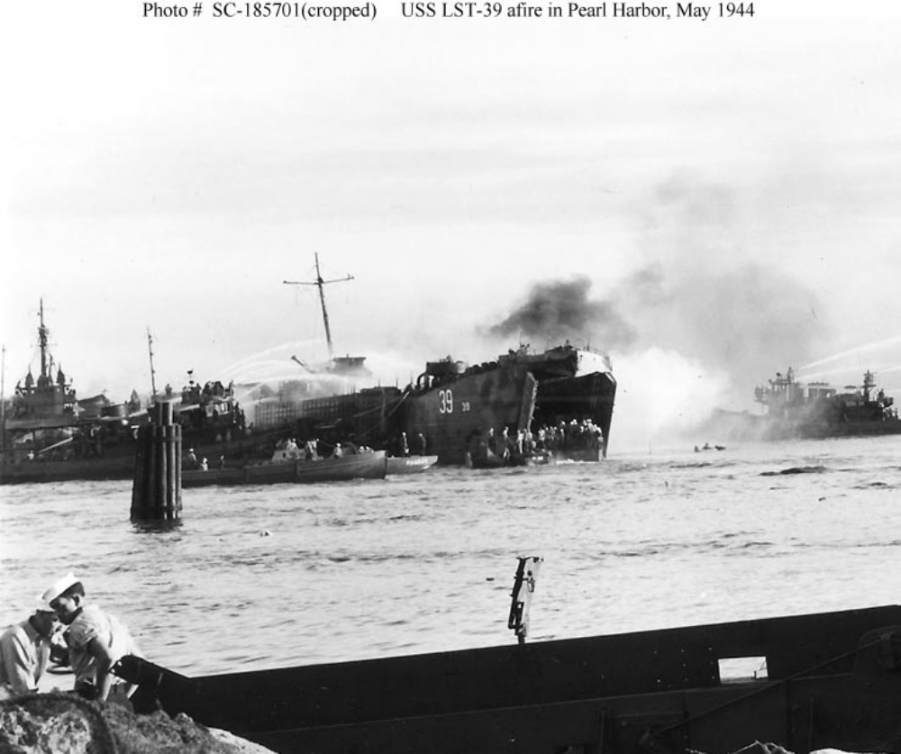
At 1508 (3:08 pm) May 21, 1944, Lualualei’s tranquility was shattered by a deafening explosion which thundered across most of Oʻahu.

Without warning, an enormous mushroom of orange black fire encapsulated LST-353 at Tare 8, obliterating it and most of the seven other ships from view as the giant fireball burst into the cloudless sky.  (Oliver)

The explosions continued, damaging more than 20 buildings shoreside at the West Loch facility. For 24-hours fires raged aboard the stricken ships.  (NPS)

Had the Japanese struck again – another sneak attack on Pearl Harbor? … No one knew.

Then the ground shook to a second blast. Earthquake?  Volcano?  Aerial bombs?  Alarms rang as another shattering blast of even greater magnitude jolted the air.  (Oliver)

Predictably, flaming gasoline and exploding ammunition soon began to take a frightful toll of the Soldiers, Sailors and Marines loading and manning the ships.

Fires and explosions drove back ships and craft engaged in firefighting efforts, each time those vessels re-entered the inferno to contain the fires and keep the disaster from spreading to the rest of the Fleet anchorage. (USNavalInstitute)

Several investigations sought to find the reason for such a disaster, but no conclusive evidence as how it occurred was decided upon.  Two major causes emerged as most likely: Either a fused mortar round was accidently dropped while unloading the LCT aboard LST-353, or the initial explosion was caused by gasoline vapors.  (Oliver)

The Navy put a “Top Secret” status on the tragedy.  Survivors and eyewitnesses to the calamity were warned under threat of prosecution not to make any mention of the disaster in letters or calls to family members. To the outside world the tragedy at West Loch simply never happened.  (Oliver)  (It was declassified in 1960.)

The total casualties were 392 dead; 163 sailors, the rest young Marines from the newly formed 2nd and 4th Marine Divisions, and 396 injured – eight ships were lost.

It was recommended that LSTs no longer be nested, so that disaster like that at West Loch could be avoided. Fleet Admiral Chester Nimitz disagreed. He felt that facilities were too limited at Pearl and that the nesting was necessary. “It is a calculated risk that must be accepted.”  (NPS)

Despite the losses, the Saipan invasion force put to sea as scheduled on June 5, 1944, just as the largest invasion armada ever to sail was crossing the English Channel en route to the Normandy beaches.

On June 15, 1944, during the Pacific Campaign of World War II (1939-45,) Admiral Turner was in charge of the assault on Saipan.  At 05:42, his orders came – “Land the landing force.” In position, about 1,250 yards from the line of departure, 34-LSTs moved into line. Two huge doors on the bow of each ship opened and dropped their ramps into the water. (BattleOfSaipan)

US Marines (having earlier trained at Camp Tarawa, Waimea, Hawaiʻi Island and Camp Maui, Ha‘ikū, Maui) stormed the beaches of the strategically significant Japanese island of Saipan, with a goal of gaining a crucial air base from which the US could launch its new long-range B-29 bombers directly at Japan’s home islands.

Facing fierce Japanese resistance, Americans poured from their landing crafts to establish a beachhead, battling Japanese soldiers inland and forcing the Japanese army to retreat north. Fighting became especially brutal and prolonged around Mount Tapotchau, Saipan’s highest peak, and Marines gave battle sites in the area names such as “Death Valley” and “Purple Heart Ridge.”  (history-com)

This was the first action of Operation Forager, the conquest of the Marianas, consisting of two Marine Divisions, a US Army Division, and the required force and support units from an amphibious armada of nearly 600-ships and craft.

When the US finally trapped the Japanese in the northern part of the island, Japanese soldiers launched a massive but futile banzai charge. On July 9, the US flag was raised in victory over Saipan.  (history-com)

© 2023 Hoʻokuleana LLC


Filed Under: Military Tagged With: Hawaii, Oahu, Pearl Harbor, LST, West Loch

May 20, 2023 by Peter T Young Leave a Comment

“Reclamation” Projects – Early-1900s

“Whenever in the opinion of the Board of Health any tract or parcel of land situated in the District of Honolulu, Island of Oahu, shall be deleterious to the public health in consequence of being low …”

“… and at times covered or partly covered by water, or of being situated between high and low water mark, or of being improperly drained, or incapable by reasonable expenditure of effectual drainage or for other reason in an unsanitary or dangerous condition…”

“… it shall be the duty of the Board of Health to report such fact to the Superintendent of Public Works together with a brief recommendation of the operation deemed advisable to improve such land.”  (So stated Section 1025, Revised Laws of the Territory of Hawaiʻi, in 1906.)

That year, Board of Health President, LE Pinkham, stated in a report “for the Making of Honolulu as Beautiful and Unique in Character, as nature has Endowed it in Scenery, Climate and Location:”

“Nature, situation and human circumstance fix world-wide prominence and importance on certain strategic points in commerce, navigation and defense. Human events have moved slowly, but are becoming intensely accelerated, and it would seem Honolulu is now beginning to fulfil her destiny.”

Likewise, laws in place gave the Superintendent of Public Works the right to make Improvements to property which had been condemned as insanitary by the Board of Health.

Also in 1906, the US War Department acquired more than 70-acres in the Kālia portion of Waikīkī for the establishment of a military reservation to be called Fort DeRussy.  Back then, nearly 85% of present Waikīkī was in wetland.

The Army started filling in the fishponds and wetland that covered most of the Fort site – pumping fill from the ocean continuously for nearly a year in order to build up an area on which permanent structures could be built.

Thus, the Army began the transformation of Waikīkī from wetlands to solid ground and it served as a model that others followed.

Back then, much of the makai lands from Honolulu to and including Waikīkī were characterized with lowland marshes, wetlands, coral reef flats and farming of fishponds along with some limited wetland kalo (taro) taro agriculture (and later rice.)

However, they were also characterized as, “stretched useless, unsightly, offensive swamps, perpetually breeding mosquitoes and always a menace to public health and welfare”.

The Territory saw the opportunity to drain and fill the land that “was valueless” to be “available for the growth of the business district of the city” and attain “a valuation greatly in excess of the cost of the filling and draining.”

Likewise, in areas such as Kakaʻako there were practical issues to contend with.   “Calmly wading around in muddy water up to waist, on Tuesday after noon last, a Kakaako housekeeper was busying herself hanging out the family washing to dry. Her clothes basket she towed after her on a raft.”

“None of the neighbors marveled at the strange sight for when it was wash-day at their places they had to do the same. Tied up at the front gates of many of the houses in the block were rafts, upon which the more particular members of the families ferried themselves back and forth from house to street”.  (Hawaiian Gazette, April 3, 1908)

This set into motion a number of reclamation and sanitation projects in Kakaʻako, Honolulu, Waikīkī, Lāhaina, Hilo and others.

The first efforts were concentrated at Kakaʻako – it was then more generally referred to as “Kewalo.”  The Kewalo Reclamation District included the area bounded by South Street, King Street, Ward Avenue and Ala Moana Boulevard.

This area already had a practical demonstration of dredging and filling.  In 1907, the US Army Fort Armstrong was built on fill over Kaʻākaukukui reef to protect the adjoining Honolulu Harbor.

“The plan practically takes in all the land from King street to the sea, and it will be the first step in a general reclamation scheme for the low lying lands of the city.”  (Hawaiian Star, October 24, 1911)

Kapālama Reclamation Project included approximately 60-acres of land between King Street and the main line of Oʻahu Railway and Land Company.  In addition, approximately 11-acres of land were filled from dredge material between Piers 16 and 17.

In 1925, the “practically worthless swamp lands” were converted “into property selling as high as $30,000.00 per acre.”

During this project, Sand Island and Quarantine Island were joined to the Kalihi Kai peninsula. In 1925 and 1926, a channel was dug from the Kalihi Channel into Kapālama Basin creating a true island out of “Sand Island.”

The Waikīkī Reclamation District was identified as the approximate 800-acres from King and McCully Streets to Kapahulu Street, near Campbell Avenue down to Kapiʻolani Park and Kalākaua Avenue on the makai side.  (1921-1928)

The dredge material not only filled in the Waikīkī wetlands, it was also used to fill in the McKinley High School site.

The initial planning called for the extension of the Ala Wai Canal past its present terminus and excavate along Makee Island in Kapiʻolani Park, connecting the Canal with the ocean on the Lēʻahi side of the project.  However, funds ran short and this extension was contemplated “at some later date, when funds are made available”; however, that never happened.

Eleven-and-a-half acres of Lāhaina “swamp land” (near the National Guard Armory,) drainage canals and storm sewers were part of the Lāhaina Reclamation District.  (1916-1917) Mokuhinia Pond was filled with coral rubble dredged from Lāhaina Harbor.

By Executive Order of the Territory of Hawaiʻi in 1918, the newly-filled pond was turned over to the County of Maui for use as Maluʻuluʻolele Park.

In Hilo, the Waiolama Reclamation Project included the draining and filling of approximately 40-acres in the area between the Hilo Railway tract, Wailoa River, and Baker and Front Streets.  It included diversion of the Alenaio Stream.  (1914-1919)

Generally, the consensus was the reclamation projects were successful in addressing the health concerns; in addition, they made economic sense.

As an example, in Waikīkī, before reclamation assessed values for property were at about $500 per acre and the same property reclaimed at ten cents a foot, making a total cost of $4,350 per acre.  The selling price after reclamation, $6,500 to $7,000 per acre, showed the financial benefit of the reclamation efforts.

© 2023 Hoʻokuleana LLC

Filed Under: Economy, General, Place Names Tagged With: Hawaii, Waikiki, Kalihi, Kewalo, Sand Island, Kapalama, Reclamation, Lahaina Wetlands, Waiolama, Ala Wai, Mokuhinia Pond

May 16, 2023 by Peter T Young Leave a Comment

Sugar, Growth Years

“The first successful sugarcane plantation was started at Kōloa, Kauai in 1835. Its first harvest in 1837 produced 2 tons of raw sugar, which sold for $200. Other pioneers, predominantly from the United States, soon began growing sugarcane on the islands of Hawaii, Maui, and Oahu.”  (HARC)

Shortly thereafter, King Kamehameha III, seeking to encourage commercial cultivation of sugar by native Hawaiians offered the “acre system,” giving “out small lots of land, from one to two acres, to individuals for the cultivation of cane.”

“When the cane is ripe, the King finds all the apparatus for manufacturing & when manufactured takes the half. Of his half one fifth is regarded as the tax due to the aupuni (government) & the remaining four fifths is his compensation for the manufacture. These cane cultivators are released from all other demands of every description on the part of chiefs.”  (Armstrong (1839;) MacLennan)

About this time, the initial signs of commercial sugar are found on Maui, in Wailuku.  In 1840, the King ordered an iron mill from the US, and it was erected by August.  Hung & Co in 1841 advertised the sale of sugar and sugar syrup from its 150-acre plantation in Wailuku. More than likely, this was sugar from the King’s Mill.  (MacLennan)

Early plantations were small and didn’t fare too well.  Soon, most would come to realize that “sugar farming and sugar milling were essentially great-scale operations.”  (Garvin)

Then, King Kamehameha III sought to expand sugar cultivation and production, as well as expand other agricultural ventures to support commercial agriculture in the Islands.  In a speech to the Legislature in 1847, the King notes:

“I recommend to your most serious consideration, to devise means to promote the agriculture of the islands, and profitable industry among all classes of their inhabitants. It is my wish that my subjects should possess lands upon a secure title; enabling them to live in abundance and comfort, and to bring up their children free from the vices that prevail in the seaports.”

“What my native subjects are greatly in want of, to become farmers, is capital with which to buy cattle, fence in the land and cultivate it properly. I recommend you to consider the best means of inducing foreigners to furnish capital for carrying on agricultural operations, that thus the exports of the country may be increased …” (King Kamehameha III Speech to the Legislature, April 28, 1847; Archives)

Hawai‘i’s economy turned toward sugar in the decades between 1860 and 1880. These twenty years were pivotal in building the plantation system. Basic features of rural factory life were established.

This was a period of rapid growth for the sugar industry, building upon the momentum triggered by the Māhele of 1848, the Kuleana Act of 1850, and the Reciprocity Treaty of 1875.  Likewise, the Civil War virtually shut down Louisiana sugar production during the 1860s, enabling Hawai‘i to compete with elevated prices for sugar.

From January 27, 1848 through March 7, 1848 King Kamehameha III participated in what we refer to as the “Great Māhele” that was a reformation of the land system in Hawaiʻi and allowed private ownership; this fundamentally changed the land tenure system to a westernized paper title system through the Māhele.

The lands were formally divided among the king and the chiefs, and the fee titles were recorded in the Māhele book.  Deeds conveying land contained the phrase “ua koe ke kuleana o na kānaka,” or “reserving the rights of all native tenants,” in continuation of the reserved tenancies which characterized the traditional Hawaiian land tenure system.  (Garavoy)

The 1850 Kuleana Act allowed “native tenants” to claim fee simple title to the lands they worked.  Those who claimed their parcel(s) successfully acquired what is known as a kuleana.

The Kuleana Act did not allow the maka‘āinana to exercise other traditional rights, such as the right to grow crops and pasture animals on unoccupied portions of the ahupua’a. The court’s interpretation of the act prevented tenants from making traditional use of commonly cultivated land.  (MacKenzie)

The growth in the size and number of sugar plantations was further fueled by the Treaty of Reciprocity – 1875 between the United States and the Kingdom of Hawai‘i that eliminated the major trade barrier to Hawai‘i’s closest and major market.

A century after Captain James Cook’s arrival in Hawaiʻi, sugar plantations started to dominate the landscape.  Hawai‘i’s economy turned toward sugar in the decades between 1860 and 1880; these twenty years were pivotal in building the plantation system.

During the Civil War boom period, the typical 1860s plantation was two hundred to three hundred acres in size, with about one hundred acres in cane, employing around one hundred workers year-round.

Hawai‘i’s government committed extensive resources to the success of sugar export. Honolulu’s merchants and financiers came to dominate sugar production. The Islands turned a corner during these decades – Hawai‘i’s dependence upon sugar began.

The fastest growth occurred on Maui, which in 1866 had twelve plantations, compared to Hawai‘i’s eight, O‘ahu’s six, and Kauai’s four.  Production on Hawai‘i Island, was just under a third of the total.

The island of Hawai’i had become the major sugar producer. Plantation statistics for the Hawaiian government in 1879 shows Hawai‘i with twenty-four plantations, Maui with thirteen, Kauai with seven, O‘ahu with seven, and Molokai with three – a total of fifty-four operations.

At the heart of this transformation was the plantation center. Unlike the commercial sugar mill, which drew on existing communities of Hawaiian workers, the plantation center represented a new clustering of population and technology.

Specifically, it was characterized by a sizable increase of foreign population, government recognition of the area as a vital economic region with distinct political needs, and by public and private investment in a shared physical infrastructure (e.g., stores, wharves, harbors) established specifically to trade with the West.

An important development in Hawai‘i’s history, the plantation center created new social institutions of dependency.  The Hawaiian government also had a significant hand in the rise of plantation centers.

The decline of whaling, collapse of the native vegetable trade, and a rapidly decreasing native population left the government with huge expenditures and little source of income.

In response, it applied public funds and assets toward the sugar trade in hopes of increasing Hawai‘i’s wealth. The Board of Immigration was established in 1866 to recruit workers for plantations. (MacLennan)

Five plantation centers changed the surrounding landscape and altered nearby Hawaiian communities. Plantations in Līhu‘e, Wailuku, Makawao, Hilo and Kohala brought an invasion of agricultural practices, technologies and repeopled the land with foreigners (from China, Portugal and Japan) and Hawaiians from other islands.

Characteristics of the five developing plantation centers separate them from the smaller sugar ventures of the period.  Plantation centers comprised several separate sugar mills and fields of different owners. Schools, stores, and worker villages sprang

up around these centers, serving the plantations.

By 1880 there were several other very new centers in Ka‘ū and Honoka’a on Hawai‘i, Lahaina on Maui, Princeville on Kauai, and several scattered plantations on O‘ahu. (MacLennan)

© 2023 Ho‘okuleana LLC

Filed Under: General, Buildings, Place Names, Economy Tagged With: Hawaii, Plantation Center

  • « Previous Page
  • 1
  • …
  • 142
  • 143
  • 144
  • 145
  • 146
  • …
  • 562
  • Next Page »

Images of Old Hawaiʻi

People, places, and events in Hawaiʻi’s past come alive through text and media in “Images of Old Hawaiʻi.” These posts are informal historic summaries presented for personal, non-commercial, and educational purposes.

Info@Hookuleana.com

Connect with Us

  • Email
  • Facebook
  • LinkedIn
  • Twitter
  • YouTube

Recent Posts

  • Carriage to Horseless Carriage
  • Fire
  • Ka‘anapali Out Station
  • Lusitana Society
  • “Ownership”
  • ‘Holy Moses’
  • Mikimiki

Categories

  • Mayflower Summaries
  • American Revolution
  • General
  • Ali'i / Chiefs / Governance
  • Buildings
  • Missionaries / Churches / Religious Buildings
  • Hawaiian Traditions
  • Military
  • Place Names
  • Prominent People
  • Schools
  • Sailing, Shipping & Shipwrecks
  • Economy
  • Voyage of the Thaddeus

Tags

Albatross Al Capone Ane Keohokalole Archibald Campbell Bernice Pauahi Bishop Charles Reed Bishop Downtown Honolulu Eruption Founder's Day George Patton Great Wall of Kuakini Green Sea Turtle Hawaii Hawaii Island Hermes Hilo Holoikauaua Honolulu Isaac Davis James Robinson Kamae Kamaeokalani Kamanawa Kameeiamoku Kamehameha Schools Lalani Village Lava Flow Lelia Byrd Liliuokalani Mao Math Mauna Loa Midway Monk Seal Northwestern Hawaiian Islands Oahu Papahanaumokuakea Marine National Monument Pearl Pualani Mossman Queen Liliuokalani Thomas Jaggar Volcano Waikiki Wake Wisdom

Hoʻokuleana LLC

Hoʻokuleana LLC is a Planning and Consulting firm assisting property owners with Land Use Planning efforts, including Environmental Review, Entitlement Process, Permitting, Community Outreach, etc. We are uniquely positioned to assist you in a variety of needs.

Info@Hookuleana.com

Copyright © 2012-2024 Peter T Young, Hoʻokuleana LLC


Loading Comments...