Images of Old Hawaiʻi

  • Home
  • About
  • Categories
    • Ali’i / Chiefs / Governance
    • American Protestant Mission
    • Buildings
    • Collections
    • Economy
    • Missionaries / Churches / Religious Buildings
    • General
    • Hawaiian Traditions
    • Other Summaries
    • Mayflower Summaries
    • Mayflower Full Summaries
    • Military
    • Place Names
    • Prominent People
    • Schools
    • Sailing, Shipping & Shipwrecks
    • Voyage of the Thaddeus
  • Collections
  • Contact
  • Follow

December 9, 2022 by Peter T Young Leave a Comment

Scorching Post Cards

According to Thrum, the first white man to stay overnight in Kilauea Caldera was CS Bartow, the postmaster of Lahaina on Maui, visiting Hawaii. Bartow suggested the nighttime excursion to his fellow travelers, and while they decided against the idea, the postmaster could not be dissuaded.

In 1898, Lorrin Thurston owner of Volcano House and head of the Hawai‘i Promotion Committee (forerunner to the Hawai‘i Visitors and Convention Bureau) worked closely with the Inter-Island Steam Navigation Company to create an excursion business from Honolulu to his hotel at Kīlauea.

Although he sold his interest in Volcano House to hotelier George Lycurgus (1858–1960) in 1904, Thurston continued to promote Kīlauea and Hawai‘i’s other natural sites.

Thurston helped with the establishment of the Hawaiʻi National Park, an entity to encompass both Kīlauea and Haleakalā.  Hawai‘i’s new National Park, established August 1, 1916, was the thirteenth in the new system and the first in a US territory.  (Chapman)

Visiting Hawaii’s volcanoes in the late nineteenth and early twentieth centuries – both before and after their designation as a National Park in 1916 – was an adventurous experience.

From Hilo, travelers had the choice of two routes to the volcanic craters; they could travel the entire thirty miles via automobile or take the railroad for twenty-two miles and a car for the remaining eight. The tourists’ destination at the crater was often Volcano House.

The majority of guidebooks from the late nineteenth century list the best time to hike the caldera as midafternoon because it provided visitors with both safe sightseeing in daylight and a closer look at Halema‘uma‘u Crater’s lava glowing in the evening.

Most travelers preferred visiting the crater in guided groups, and – armed with food, supplies, and postcards provided by Volcano House – trekked down the caldera’s well-marked trail and enjoyed lava-formed wonders.  (Chisholm)

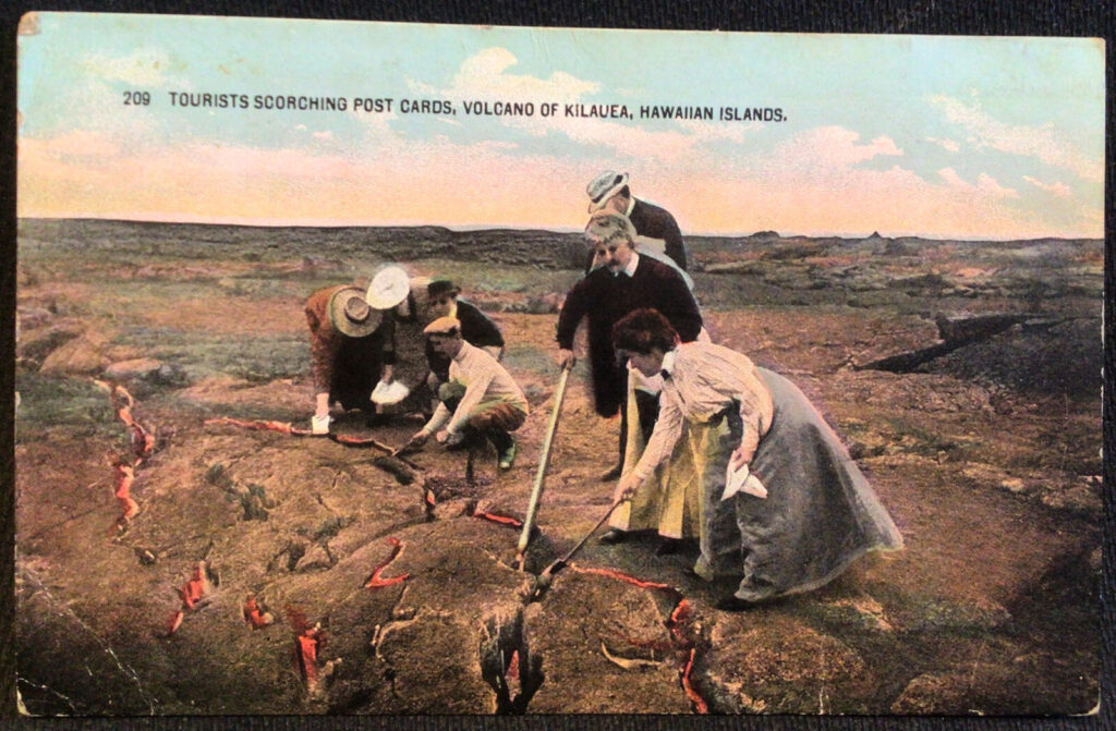
“Visitors to Kilauea Caldera used to take sport in lowering sticks with food or souvenirs into the fissures.  Some enjoyed a dinner of eggs and potatoes cooked by the volcano, while others scorched postcards to mail back home.”  (Alice Kim)

“A unique entertainment tendered us was a dinner served within five feet of the pit. Lumber to build table and benches had been brought down on the backs of horses.”

“An excellent meal was served, everything being cooked at the hot cracks on the crater. This is a favorite method of visitors, many of whom make steaming hot coffee over the cracks …” (Congressional Party in Hawaii, May 1907)

“[T]he sulphur and steam cracks in the crust were especially hot, prompting tourists to lower sticks holding food and souvenirs into the fissures. Many tours enjoyed a dinner of eggs and potatoes cooked by the volcano’s heated vents, while others brewed coffee”. (Postal Museum)

“These cracks can be found at many places for some distance around the pit. … Nothing quite so elaborate had ever been attempted here before.”

“The desolate grandeur of the place was impressive and the weird surroundings made a scene such as one will seldom look upon in a lifetime.” (Congressional Party in Hawaii, May 1907)

“In letters written about his own experience at Kilauea in 1907, Pennsylvania Representative Ernest Acheson remarked that, ‘An excellent meal was served, everything being cooked at the hot cracks on the crater … and the weird surroundings made a scene such as one will seldom look upon in a lifetime.’” (Postal Museum)

© 2022 Ho‘okuleana LLC

Filed Under: General Tagged With: Hawaii Island, Volcano, Post Card, Scorching

December 1, 2022 by Peter T Young Leave a Comment

Kalalea Heiau

Ka Lae is the site of one of the earliest Hawaiian settlements, and it has one of the longest archaeological records on the islands (included in the complex is the earliest recorded occupation site.)  (NPS)  Ka Lae (Lit., the point, commonly called South Point) on the Island of Hawaiʻi is the southernmost point in the fifty states.

Kaʻū is poetically known as “Kaʻū kua makani” (Kaʻū with windy back.) (Soehren)  An offshore stone at South Point is called Pokakuokeau (stone of the current) referring to the meeting of the different ocean currents that come together here.  (k12-hi-us)

Nā kai haele lua o Kalae, ʻO Kāwili lāua ʻo Halaʻea
The two sea currents of Kalae – Kāwili and Halaʻea

The Halaʻea current (named after a chief,) comes from the east to Kalae and sweeps out to sea. The Kāwili (Hit-and-twist) comes from the west and flows out alongside the Halaʻea. Woe betide anyone caught between.  (Keala Pono)

Here at the point is a heiau, Kalalea Heiau, located in the ahupuaʻa of Kamāʻoa.  In 1906, Stokes, in describing the heiau, said, “This heiau was … 43 by 35 ft., with platforms outside … adjoining its western wall ….”  The heiau complex has a small terraced platform paved with ʻiliʻili (small, smooth pebbles.) When Stokes visited the heiau, an informant told him that the heiau was Kamehameha’s and was very sacred.

Ten years later another informant told Stokes the following: “(This is the) history of the heiau of Kalalea at Kalae, and of Kūʻula, Wahinehele and ʻAiʻai. Kūʻula (a male) married Wahine (a female) and they had a son ʻAiʻai.”

“They left Kahiki and came to these islands, settling on Kauaʻi. ʻAiʻai left his parents on Kauai and went on a sightseeing tour to the islands of Oʻahu, Molokai, Maui and Hawaii.”

“When he reached Kalae, he looked around and saw that it was a fine country, and a nice place to live in and well supplied with fish. He returned to Kauai and brought his parents back with him, and they all lived at Kalae.  While his parents were living at Kalae, ʻAiʻai set out for Kahiki and brought back many people, — kilokilo (seers,) kuhikuhipuuone (architects who made plans in the sand) and ai puʻupuʻu (stewards).”

“He also brought back many different kinds of food, such as breadfruit, bananas, awa, cocoanuts, sugar cane, sweet potatoes, kalo, papaya, hapuʻu and pala (both edible ferns) and other foods in great quantity.”

“And when ʻAiʻai saw that the food and the men were ready, he gave commands to all the Menehune and the erection of the heiau went on until the walls were completed.”

“It was named Kalalea, which name still stands today.”  Today, people reference Kalalea as a fishing heiau. There were stones that represent the fishing gods Kūʻula and ʻAiʻai.

On the main platform is a stone called Kumaiea (female), but also attributed to Kāne, and on the smaller platform just mauka is another upright stone called kanemakua (male), associated with the god Kanaloa.

Standing twelve feet to the north of the heiau are two more stones, the northerly one called ʻAiʻai, the son or Kūʻula.  Within the heiau, beside the mauka wall, is a rock called Kūʻula, the god of fishermen.  (k12-hi-us)

In 1953 Emory obtained the following information from Mary Kawena Pukui: “One must not wear red on the beaches at Kalae where Kalalea Heiau is located. Women never went inside the heiau. The kūʻula of this heiau is a shark. It is a heiau hoʻoulu (to increase) opelu (mackerel), malolo (flying fish), and ahi (tuna).”

Directly seaward of Kalalea Heiau is a rough ledge of lava, with low cliffs dropping into the ocean.  About eighty holes (like cleats) are carved into the lava to moor canoes (either for positioning over fishing grounds or to tie-up to shore.)  (Kirch)  While many have suggested the heiau is fishing related, it appears to also have links to navigation.

Immediately behind the heiau is a modern navigational beacon.  First proposed in 1883, a lens-lantern supported by a 34-foot wooden mast was ready for display on March 5, 1906.  Its light, visible for nine miles, was produced by incandescent oil vapor.

After several modifications and improvements, the present 32-foot concrete pole was built in 1972. The automated, battery powered light is charged by solar panels.

In at least the 1940s and early-1950s, the military had a landing facility, Morse Field, in this area.  There was limited infrastructure; the planes landed/took off on the grassy runway.

At a lecture at Hawaiian Mission Houses, I heard another series of stories related to Kalalea Heiau, told by John Laimana (a descendent of the area, whose family has direct association with the heiau;) while similar to much of the other explanations, he expands upon the navigational aspects of the heiau to Kahiki (Tahiti) and Rapanui (Easter Island.)

John says the heiau is actually the smaller of the structures there, makai of the larger, stonewalled rectangle (the larger he says is a fishers’ shelter.)  More importantly, he notes that the heiau structure aligns east and west – and one wall aligns with magnetic north.

Equally more important, he looks beyond the heiau structure and also looks at the larger surrounding perimeter wall structure.  Careful review of that shows the two walls are in precise, straight alignment.

OK, here’s another overlooked feature … extending the alignment of the walls, thousands of miles across the ocean lead you to Maupiti (in French Polynesia, near Tahiti) and Rapanui (Easter Island, Chile.)

In Hawaiian, Panana means compass, especially a mariner’s compass.  Panana are also referred to “sighting walls.”  The alignment of the walls (within the heiau and the perimeter walls,) may have been used for navigational purposes.

Oh, one more thing … Kaʻū is an ancient name with similar derivations in Samoa (Taʻū) and Mortlock (Marqueen) Islands (Takuu; an atoll at Papua New Guinea.)  (Pukui)  (This heiau may have links across the extent of the South Pacific.)

© 2022 Hoʻokuleana LLC

Filed Under: Hawaiian Traditions, Place Names Tagged With: Panana, Maupiti, Kalae, Hawaii, Kalalea Heiau, Hawaii Island, Heiau, Morse Field, Kau, South Point, Big Island, Rapanui

November 23, 2022 by Peter T Young Leave a Comment

Pololū

A Prophecy of Keʻāulumoku (1716‐1784) on the Rise of Kamehameha

Exalted sits the chief and from on high looks forth;
He views the island; far down he sees the beauteous lands below.
Much sought after, hoped for, the island as sought for is seen …
Let him live forever. O let him live …
Let the little chiefs under him live.
Let the father chiefs live under his protection,
Let the soldiers live who fought in former times,
Let the mass of people live ‐ the common people …

Keʻāulumoku predicted “that Kamehameha would triumph over his enemies, and in the end be hailed as the greatest of Hawaiian conquerors.  (Kalākaua)

His prophecy came true.  Kamehameha I is universally recognized as being the greatest figure in the history of the Hawaiian people, and as being of significance even in world history.  (Hawaiian Historical Society)

Many estimate that Kamehameha the Great was born 1758 in North Kohala on the island of Hawaiʻi (the exact date of the birth is not known.)  His father was Keōua; his mother was Chiefess Kekuʻiapoiwa of the Kohala district on the island of Hawaiʻi.

Fearing for her son’s life, Kekuʻiapoiwa, sent him to live with Kahanui and Kahāʻopūlani where Kamehameha grew up in seclusion. (Topolinski)  Paiea, which means “hard-shelled crab,” and Kamehameha, which means “the lonely one,” literally defined Kamehameha’s isolated childhood experience.

Kokoiki, Kamehameha’s birthplace, means ”little blood,” referring to the first signs of childbirth. Hawi, meaning ”unable to breathe,” was where the child, being spirited away by a servant, required resuscitation and nursing. Kapaʻau, meaning ”wet blanket,” was where heavy rain soaked the infant’s kapa (blanket.)  Halaʻula (scattered blood) was the town where soldiers were killed in anger.  (Sproat – (Fujii, NY Times))

Word went out to find and kill the baby, but the Kohala community conspired to save him. The future King was carried on a perilous journey through Kohala and Pololū Valley to Awini.  (KamehamehaDayCelebration)  Some believe Kamehameha also spent much of his teen years in Pololū (Lit long spear.)

“Pololū is a pleasant village situated in a small cultivated valley, having a fine stream of water flowing down its centre, while lofty mountains rise on either side.  The houses stand principally on the beach, but as we did not see many of the inhabitants, we passed on, ascended the steep mountain on the north side, and kept on our way.”  (Ellis, 1826)

“The country was fertile, and seemed populous, though the houses were scattered, and more than three or four seldom appeared together. The streams of water were frequent, and a large quantity of ground was cultivated on their banks, and in the vicinity.”  (Ellis, 1826)

Pololū is one of three primary quarry sites for the material for stone adzes on the Island of Hawaiʻi (Mauna Kea and Kilauea Volcano, the other two.)  Stones beside the main stream in the valley floor were used. In general, the Pololū material is coarser grained than stone from Mauna Kea.  (Withrow)

Pololū played a prominent role in Kamehameha’s later life.  In 1790 (at the same time that George Washington was serving as the US’s first president,) the island of Hawaiʻi was under multiple rule; Kamehameha (ruler of Kohala, Kona and Hāmākua regions) successfully invaded Maui, Lānaʻi and Molokaʻi.

He sent an emissary to the famous kahuna (priest, soothsayer,) Kapoukahi, to determine how he could conquer all of the island of Hawaiʻi.  According to Thrum, Kapoukahi instructed Kamehameha “to build a large heiau for his god at Puʻukoholā, adjoining the old heiau of Mailekini.”

“When it came to the building of Puʻukoholā no one, not even a tabu chief, was excused from the work of carrying stone. Kamehameha himself labored with the rest. The only exception was the high tabu chief Kealiʻimaikaʻi (Kamehameha’s younger brother).”

“Thus Kamehameha and the chiefs labored until the heiau was completed, with its fence of images (paehumu) and oracle tower (anuʻunuʻu), with all its walls outside and the hole for the bones of sacrifice. He brought down the ʻōhiʻa tree for the haku ʻōhiʻa and erected the shelter house (hale malu) of ʻōhiʻa wood for Kū-kaʻili-moku according to the rule laid down for the kahuna class of Pā‘ao.”  (Kamakau)

It is estimated that the human chain from Pololū Valley to Puʻukohola had somewhere between 10,000-20,000 men carrying stones from Pololū Valley to Kawaihae. (NPS)

After completing the heiau in 1791, Kamehameha invited Keōua to come to Kawaihae to make peace.  However, as Keōua was about to step ashore, he was attacked and killed by one of Kamehameha’s chiefs.

With Keōua dead, and his supporters captured or slain, Kamehameha became King of Hawaiʻi island, an event that according to prophesy eventually led to the conquest and consolidation of the islands under the rule of Kamehameha I.

In more modern times, Pololū played a role in other military means.  During World War II, the US military established Camp Tarawa in Waimea, South Kohala, and trained over 50,000 servicemen between 1942 and 1945 – they were preparing for battle in the south Pacific (Solomon Islands, Tarawa and Iwo Jima.)

The Kohala Coast was used to simulate the coast of Iwo Jima, an island south of the Japanese main islands that would be the site of a bloody invasion and victory for the Marines. To maintain secrecy, the invasion target was called “Island X.” In addition to other training, amphibious craft staged landings in Pololū Valley, and endured live-fire training, all of which took the lives of several Marines during the Camp Tarawa years.  (Paul J. Du Pre) (A remnant of a track vehicle is on Pololū Valley’s floor.)

Access into the valley is via a state Na Ala Hele trail (at the end of Highway 270;) a lookout offers spectacular views into the valley and the secluded Kohala/Hāmākua coastline.

© 2022 Hoʻokuleana LLC


Filed Under: Place Names Tagged With: Na Ala Hele, Hawaii, Hawaii Island, Kamehameha, Hamakua, Keoua, Kohala, Puukohola, Big Island, Pololu

November 3, 2022 by Peter T Young 1 Comment

John Ena

Shortly after the arrival of Captain James Cook and his crews in 1778, the Chinese found their way to Hawaiʻi.  Some suggest Cook’s crew gave information about the “Sandwich Islands” when they stopped in Macao in December 1779, near the end of the third voyage.

As more ships came, crewmen from China were employed as cooks, carpenters and artisans; and Chinese businessmen sailed as passengers to America. Some of these men disembarked in Hawaiʻi and remained as new settlers.

The growth of the Sandalwood trade with the Chinese market (where mainland merchants brought cotton, cloth and other goods for trade with the Hawaiians for their sandalwood – who would then trade the sandalwood in China) opened the eyes and doors to Hawaiʻi.  The sandalwood trade lasted for nearly half a century – 1792 to 1843.  (Nordyke & Lee)

The Chinese pioneered another Hawaiʻi industry – sugar.  Starting in the 1850s, when the Hawaiian Legislature passed “An Act for the Governance of Masters and Servants,” a section of which provided the legal basis for contract-labor system, labor shortages were eased by bringing in contract workers from Asia, Europe and North America.

Among the Chinese in the Hawaiian Islands before the importation of sugar labor in 1852, there was a group who settled in Hilo. They were all sugar manufacturers or “sugar masters”; they all married Hawaiian women.

The Chinese names of the men in this group were Hawaiianized; one of them, Zane (or Tseng) Shang Hsien (pronounced In) became known as John Ena.  (Chinese ‘Shang’ sounds like John; the last name Ena is pronounced as a long e; he also went by Keoni Ina and a couple other variations of the name.)

John Ena was one of the group of Chinese men who had a sugar plantation and mill on Ponahawai hill; he may have been in Kohala before coming to Hilo.

This early sugar mill was started in 1839 by Lau Fai (AL Hapai,) Zane Shang Hsien (John Ena Sr) and Tang Chow (Akau) along Alenaio stream by today’s Hilo Central Fire Station. Zane Moi (Amoi) had the plantation producing 20,000-lbs of sugar by 1851. But the mill burned down in 1855 and they abandoned the property.  (Narimatsu)

In addition to John Ena’s association with the other Chinese in the Ponahawai sugar plantation, he was also associated at various times with Chinese groups in the plantations at Paukaʻa, Pāpaʻikou and Amauʻulu. (Kai)

It is not known how much influence these early sugar plantations had upon the later development of the sugar industry in Hawaiʻi, but it is known that they were the pioneers, struggling with the problems of labor, droughts, fluctuating prices, water supplies, and probably insects, rats and other difficulties that plague the commercial growing of sugar.  (Kai)

Sometime before 1842, Ena married Kaikilani “Aliʻi Wahine O Puna;” she is said to be part of the Kamehameha line, going back to Lonoikamakahiki.  The Enas had three children: daughters, Amoe Ululani Kapukalakala, born in 1842 (later married to High Chief Levi Haʻalelea and Laura Amoy Kekukapuokekuaokalani, born in 1844 or 1845 (later, Laura Coney.)

An interesting insight into John Ena’s attitude toward the education of his children is noted in a letter written by the Reverend Titus Coan to Dr Charles H Wetmore in 1850, when Dr Wetmore was away from Hilo: “Keoni Ina is anxious to get a strip of land 8 fathoms wide on the makai side of your makai field running from Punahoa Street (formerly Church Street, now Haili) to More’s fence. He says he only wishes to put a dwelling house … (so) that his children may be nearer school.”  (Kai)

Dr. Wetmore was apparently not interested in selling this land, but John Ena did get land near to the school. In 1851, he leased almost an acre from a Hawaiian man named Kalakuaioha for twenty years. This was on the Puna side of the present Haili Street, between Kinoʻole and Kilauea Streets.  (Kai)

These Chinese settlers were written about by the editor of the Polynesian in 1858 (possibly referring to Amoe Ululani Ena):  “In Hilo, I was told, over and over again, the girls of half-Chinese and half-Hawaiian origin were the best educated, the most fluent in the English language, the neatest housewives, and the most likely young ladies. …”

“One young lady of such origin … was married just before I arrived to a chief of considerable wealth, and if all that is said about her is true, he ought to be looking upon himself as one of the happiest and luckiest of men, for besides being possessed of the usual attractions, the bride, they say, is sensible.”

“The gossip in the village Hilo … was that she laid down some most excellent conditions, and only upon receiving a promise that they would be observed, did she consent to renounce her parents care. …”

“But fancy a young country girl, whose world had been the village of Hilo, with an ardent, not to say remarkably well-off lover at her feet, dictating the terms upon which she would consent to become rich, dress handsomely and live in a large house in the metropolis! Ah, John Chinaman, your pains were not thrown away.” (Kai)

A son to John Ena Sr and Kaikilani, John Ena Jr, was born November 18 1845 in Hilo.  He is the subject of the rest of this summary.

John Ena Jr worked at various trades until at the age of thirty-four he became a clerk for TR Foster & Co of Honolulu.

This firm owned a fleet of seven schooners plying among the islands and soon acquired its first steamer in 1883 as the Inter-Island Steam Navigation Co, and Ena invested heavily in the stock.  He became president of Inter-Island Steam Navigation Co in 1899.

Inter-Island’s ships traveled to Kauai and the Kona and Kaʻū Coasts of the island of Hawai‘i.  The Wilder Company served the island of Maui and the windward port of Hilo.

In 1905, Ena merged Inter-Island with the Wilder Company, under the Inter-Island name.  (Later, Inter-Island became Inter-Island Airways (1941,) then Hawaiian Airlines (1947.))

Ena was a member of the House of Nobles and the Privy Council under the Kalākaua and Liliʻuokalani and was decorated in 1888 by King Kalākaua.

He served with the Board of Health under the Provisional Government and was a member of the constitutional convention that set up the Republic of Hawaiʻi.  He reportedly circulated and published the newspaper Ka Naʻi Aupuni in 1905.

Ena died on December 12, 1906 in Long Beach, California.

When Henry J Kaiser planned and developed his Waikīkī resort in 1954, he and his partner purchased 7.7-acres of Waikīkī beachfront property from the John Ena Estate and several adjoining properties.

In mid-1955 the first increment of what is now the Hilton Hawaiian Village opened for business; the first self-contained visitor resort in Waikīkī.  A nearby road, Ena Road, was named after John Ena (Jr.) Image shows John Ena Jr.

© 2022 Hoʻokuleana LLC

Filed Under: Economy, Prominent People Tagged With: Hawaii, Waikiki, Hawaii Island, Hilo, Sugar, Chinese, John Ena, Hilton Hawaiian Village

October 20, 2022 by Peter T Young Leave a Comment

Pāhoa

Early settlement patterns in the Islands put people on the windward sides of the islands, typically along the shoreline.  However, in Puna on the Island of Hawaiʻi, much of the district’s coastal areas have thin soils and there are no good deep water harbors. The ocean along the Puna coast is often rough and windblown.

As a result, settlement patterns in Puna tend to be dispersed and without major population centers. Villages in Puna tended to be spread out over larger areas and often are inland, and away from the coast, where the soil is better for agriculture.  (Escott)

This was confirmed on William Ellis’ travel around the island in the early 1800s, “Hitherto we had travelled close to the sea-shore, in order to visit the most populous villages in the districts through which we had passed. But here receiving information that we should find more inhabitants a few miles inland, than nearer the sea, we thought it best to direct our course towards the mountains.”  (Ellis, 1823)

An historic trail once ran from the modern day Lili‘uokalani Gardens area in Hilo to Hāʻena along the Puna coast. The trail is often referred to as the old Puna Trail and/or Puna Road. There is an historic trail/cart road that is also called the Puna Trail (Ala Hele Puna) and/or the Old Government Road.

This path was essentially the main thoroughfare through the Puna district before the late-1800s.  Pāhoa was oʻioʻina (a resting place) on the trail.  (Papakilo)  Then it grew to become the principal town of lower Puna.

The evolving trail (first by foot, then by horse, cart and buggy, and finally by automobile) likely incorporated segments of the traditional Hawaiian trail system often referred to as the ala loa or ala hele.  (Rechtman)

The full length of the Puna Trail, or Old Government Road, might have been constructed or improved just before 1840. The alignment was mapped by the Wilkes Expedition of 1804-41.  (Escott)

People who traditionally had lived along the Puna coast were moving toward Hilo and into the more fertile upland areas of Puna in order to find paid work and to produce cash crops for local markets and for export.

The focus began to shift to the center of the Puna District and the developing sugar and related industries near ʻŌlaʻa, Hilo and the volcano region.

Before the turn of the century, railroad operations began – with lines running into Hilo. A main railroad line and several feeder lines were constructed in the early-1900s from Keaʻau to locations in lower Puna District.

The major line ran from Hilo through Keaʻau to the Kapoho area.  A branch line ran from the ʻŌlaʻa Sugar Mill up past present day Glenwood. A second branch line ran to Pāhoa town.

Some suggest this is how Pāhoa received its name.  “Then the train was put in from Hilo to Puna. One spur went up into Pāhoa; it was like a dagger into the forest. I‘m told this is how Pāhoa got its name. (Pāhoa means dagger.)”  (Edwards; Cultural Surveys)

People began to work in the inland areas to grow sugarcane. The new road, the Pāhoa branch of the railroad, sugarcane agriculture and a logging venture all combined to create Pāhoa as a population center in the region.  (Rechtman)

Macadamia nuts and papaya were introduced in 1881 and 1919; at the turn of the century, large-scale coffee cultivation was attempted.  Over 6,000-acres of coffee trees were owned by approximately 200-independent coffee planters.

This fledgling industry couldn‘t compete with more successful ventures located in other districts, and after a few decades the coffee industry in Puna was abandoned.  (Cultural Surveys, Rechtman)

By 1901, sugar dominated the island’s industry and landscape, and Hilo was the epicenter of production and export. Railroads connected sugar mills and sugar plantations in Hilo, the Hāmākua and Puna. The railroad also connected the mills to the wharves at Hilo Bay.

Early on, one of the major export items transported by the railroad was timber.  Starting in 1907, the Hawaiian Mahogany Company began cutting trees to clear land for sugarcane. The logs were brought to Pāhoa Town to be milled, then sent to Hilo Harbor and eventually shipped to the US Mainland as railroad ties for the Santa Fe Railroad.

The lumber mill facilities and the railroad line that served them were located near the center of town where the Akebono Theater is located.

In 1909, the company was renamed Pāhoa Lumber Company. In 1913, the main mill facilities were lost in a fire; it was rebuilt that year the company was renamed the Hawaiian Hardwood Company.

The company closed down in 1916 when the Santa Fe Railroad ended its contract to buy lumber. The defunct company then leased its mill facilities, buildings and railroad tracks to the expanding ʻŌlaʻa Sugar Company.  (Rechtman)

Today, Pāhoa Town has a main street – the former highway route before the construction of the by-pass road – that still retains much of the original street-wall of plantation-era structures, as well as some significant stand-alone buildings.

Most of the uses are commercial or civic.  The County has acquired a large tract of land within Pāhoa Town, which presents a significant opportunity for community revitalization and a possible catalyst for economic activity.  (Puna CDP)

© 2022 Hoʻokuleana LLC

Filed Under: Economy, General, Place Names Tagged With: Hawaii, Hawaii Island, Puna, Pahoa, Sugar, Coffee, Macadamia Nuts

  • « Previous Page
  • 1
  • …
  • 12
  • 13
  • 14
  • 15
  • 16
  • …
  • 36
  • Next Page »

Images of Old Hawaiʻi

People, places, and events in Hawaiʻi’s past come alive through text and media in “Images of Old Hawaiʻi.” These posts are informal historic summaries presented for personal, non-commercial, and educational purposes.

Info@Hookuleana.com

Connect with Us

  • Email
  • Facebook
  • LinkedIn
  • Twitter
  • YouTube

Recent Posts

  • Happy Father’s Day!
  • The Apology & the Supreme Court
  • Hawai‘i Seven
  • Bull Pen
  • About 250 Years Ago … Battle of Bunker Hill
  • About 250 Years Ago … George Washington
  • 50-Star US Flag

Categories

  • Place Names
  • Prominent People
  • Schools
  • Sailing, Shipping & Shipwrecks
  • Economy
  • Voyage of the Thaddeus
  • Mayflower Summaries
  • American Revolution
  • General
  • Ali'i / Chiefs / Governance
  • Buildings
  • Missionaries / Churches / Religious Buildings
  • Hawaiian Traditions
  • Military

Tags

Albatross Al Capone Ane Keohokalole Archibald Campbell Bernice Pauahi Bishop Charles Reed Bishop Downtown Honolulu Eruption Founder's Day George Patton Great Wall of Kuakini Green Sea Turtle Hawaii Hawaii Island Hermes Hilo Holoikauaua Honolulu Isaac Davis James Robinson Kamae Kamaeokalani Kameeiamoku Kamehameha Schools Lalani Village Lava Flow Lelia Byrd Liberty Ship Liliuokalani Mao Math Mauna Loa Midway Monk Seal Northwestern Hawaiian Islands Oahu Papahanaumokuakea Marine National Monument Pearl Pualani Mossman Quartette Thomas Jaggar Volcano Waikiki Wake Wisdom

Hoʻokuleana LLC

Hoʻokuleana LLC is a Planning and Consulting firm assisting property owners with Land Use Planning efforts, including Environmental Review, Entitlement Process, Permitting, Community Outreach, etc. We are uniquely positioned to assist you in a variety of needs.

Info@Hookuleana.com

Copyright © 2012-2024 Peter T Young, Hoʻokuleana LLC

Loading Comments...