There are two rivers in the Hawaiian Islands bearing the name of Wailuku. One is on the Island of Maui, flowing out of a deep gorge in the side of the extinct volcano ‘Īao. The other Wailuku River is on the Island of Hawaii.
The Wailuku is the longest river in Hilo (twenty-six miles.) Its course runs from the mountains to the ocean. The Wailuku is the boundary between Hilo Palikū in the north and Hilo One on the south.
Hawaiians were impressed by this Wailuku and wove a dramatic tale around several interesting geologic features within the river.
Hina, the moon goddess and mother of Maui, lived in the cave beneath Rainbow Falls, concealed by the mist of the falls. Each day she beat and dried her kapa in the sun.
Far above the cave, in the bed of the river, dwelt Kuna. [Kuna is a variety of freshwater eel [or Mo‘o (dragon)] said to have been introduced from abroad. (Parker)] That portion of the river runs bears to this day the name ‘Waikuna’ or ‘Kuna’s river.’
Kuna often tormented Hina by sending over great torrents of water or by rolling logs and boulders down the stream. This would block the stream below the falls to dam the river and drown Hina.
Hina was frequently left with but little protection, and yet from her home in the cave feared nothing that Kuna could do. Precipices guarded the cave on either side, and any approach of an enemy through the falling water could be easily thwarted.
During a particularly intense storm, Mo‘o Kuna moved a huge boulder over the falls and into the river, where it fit perfectly and prevented water from flowing farther. Water level beneath the falls began to rise.
Hina, realizing her danger, signaled her son. With two powerful strokes, he paddled his canoe from Maui to the mouth of the Wailuku. He rushed upstream and split the damming boulder with a single blow, thereby saving his mother.
By this time, Kuna had fled upstream. Maui found Kuna hiding in a hole beneath the river. He tried to spear Kuna, but Kuna escaped. Finally, Kuna found deep hiding holes and thought to be safe.
Maui again found Kuna and called upon Pele to send lava into the river to drive out Kuna. The red-hot burning stones in the water made the pools boiling and the steam was rising in clouds – Kuna uttered incantation after incantation, but the water scalded and burned Kuna.
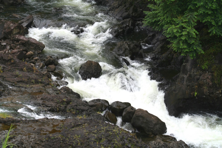
Kuna leaped from the pools and fled down the river. The waters of the pools are no longer scalding, but they have never lost the tumbling, tossing, foaming, boiling swirl which Maui gave to them when he threw into them the red-hot stones with which he hoped to destroy Kuna, and they are known today as the ‘Boiling Pots.’ (Westervelt, USGS)
Despite the name, the water is not normally hot. The only time in the modern history of the river that the water was heated was in 1855 and 1856 when a lava flow from Mauna Loa advanced across the Saddle between that volcano and Mauna Kea. Lava flowed into the Wailuku River channel, but did not cross it, about 4 miles above the Boiling Pots. (BIVN)
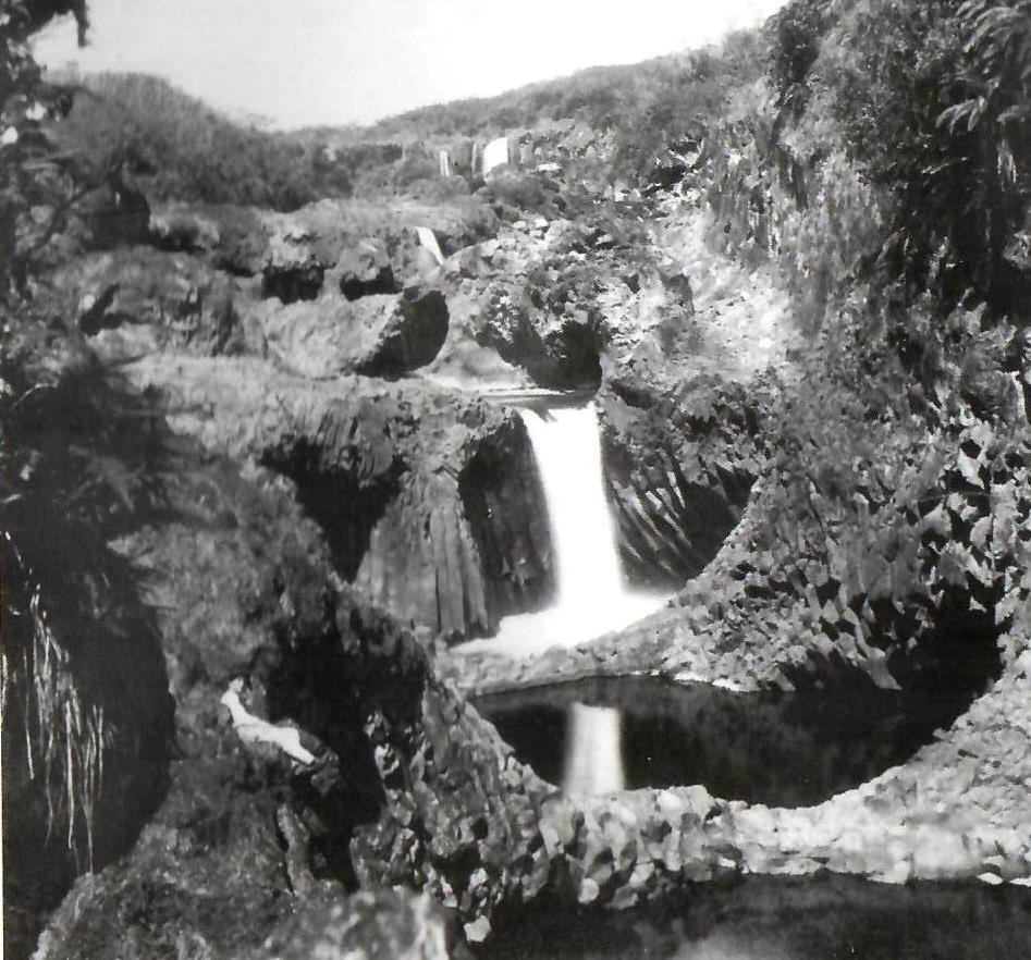
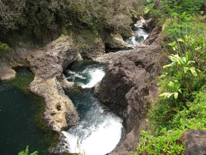
The Boiling Pots is about 1.5 miles upstream from Rainbow Falls and is a succession of eroded, hollowed out terraced pools that fill with the flow of the river. When the river is engorged with storm runoff, the ‘pots’ fill to the brim, become turbulent and appear to ‘boil.’ (HawaiianAir)
The Wailuku River is an important landmark to geologists, because it marks the approximate boundary between the lava flows of Mauna Kea and Mauna Loa. It is the state’s longest river and the southernmost that carries water all year.
According to the USGS, the river was formed by at least two lava flows coming from Mauna Kea, the oldest, the ‘Anuenue flow (as old as 10,500 years), is the same flow that formed the thick lip of Rainbow Falls and most of the rounded, gray boulders at Boiling Pots.
Tracing the flows up and down the Wailuku tells a geologic story of a river that had already deeply cut into Mauna Kea and Mauna Loa flows when it was filled by the ‘Anuenue flow over 10,000 years ago. Many of these boulders are frozen into a younger pahoehoe flow, named after the Punahoa ahupua‘a and about 3,100 years old.
The filling caused the river to shift in many places and resume its erosional downcutting before lava again ventured into the river 3,100 years ago. (The Hawaiian and the geologic versions of the Wailuku River story have many similarities, including the pools – ‘pots.’ (USGS)
The pots, each about 50-feet in diameter, are eroded into the 10,500 year old Mauna Loa lava flow. When the water is low, the river does not flow over some of the pot rims but it continues to flow through them. (USGS)
An average of 275-million gallons of water flows through the Wailuku to Hilo daily – during intense storms, the discharge can be more than 20 times greater. On average, the Wailuku transports approximately 10 tons of suspended sediment into Hilo Bay each day.
About a half mile up the river from the boiling pots is Peʻepeʻe Falls. Waiānuenue Avenue (rainbow (seen in) water) is named for the most famous waterfall, Ka Wailele ʻO Waiānuenue, Rainbow Falls on the Wailuku River.
DLNR operated the Wailuku River State Park, here. There are two separate park areas, Boiling Pots and Rainbow Falls. Flash flooding is common, and because there are no lifeguards, many have perished in the river by getting sucked into the water and becoming trapped within concealed lava tubes and caves.
The best way to experience this beautiful and deadly natural phenomena is from a cement overlook, just a short walk from the paved parking lot.


-AhaMoku")

")
")


-1934")


