Images of Old Hawaiʻi

  • Home
  • About
  • Categories
    • Ali’i / Chiefs / Governance
    • American Protestant Mission
    • Buildings
    • Collections
    • Economy
    • Missionaries / Churches / Religious Buildings
    • General
    • Hawaiian Traditions
    • Other Summaries
    • Mayflower Summaries
    • Mayflower Full Summaries
    • Military
    • Place Names
    • Prominent People
    • Schools
    • Sailing, Shipping & Shipwrecks
    • Voyage of the Thaddeus
  • Collections
  • Contact
  • Follow

December 8, 2021 by Peter T Young 1 Comment

R&R Facility to Prison

A century after Captain James Cook’s arrival in Hawaiʻi, sugar plantations started to dominate the Hawai‘i landscape. Hawai‘i’s economy turned toward sugar in the decades between 1860 and 1880; these twenty years were pivotal in building the plantation system.

However, a shortage of laborers to work in the growing (in number and size) sugar plantations became a challenge.  The only answer was imported labor.

Starting in the 1850s, when the Hawaiian Legislature passed ‘An Act for the Governance of Masters and Servants,’ a section of which provided the legal basis for contract-labor system, labor shortages were eased by bringing in contract workers from Asia, Europe and North America.

There were three big waves of workforce immigration: Chinese 1852; Japanese 1885; and Filipinos 1905.  Several smaller, but substantial, migrations also occurred: Portuguese 1877; Norwegians 1880; Germans 1881; Puerto Ricans 1900; Koreans 1902 and Spanish 1907.

In March 1881, King Kalākaua visited Japan during which he discussed with Emperor Meiji Hawaiʻi’s desire to encourage Japanese nationals to settle in Hawaiʻi.

Kalākaua’s meeting with Emperor Meiji improved the relationship of the Hawaiian Kingdom with the Japanese government and an economic depression in Japan served as motivation for Japanese agricultural workers to move from their homeland.  (Nordyke/Matsumoto)

The first 943-government-sponsored, Kanyaku Imin, Japanese immigrants to Hawaiʻi arrived in Honolulu on February 8, 1885.  Subsequent government approval was given for a second set of 930-immigrants who arrived in Hawaii on June 17, 1885.

With the Japanese government satisfied with treatment of the immigrants, a formal immigration treaty was concluded between Hawaiʻi and Japan on January 28, 1886. The treaty stipulated that the Hawaiʻi government would be held responsible for employers’ treatment of Japanese immigrants.

The Issei (first generation) were born in Japan and emigrated to Hawai‘i from 1885 to 1924 (when Congress stopped all legal migration.)  (The Immigration Act of 1924 (aka Johnson-Reed Act) limited the number of immigrants allowed entry into the US through a national origins quota. It completely excluded immigrants from Asia.  (State Department))

The sugar industry came to maturity by the turn of the century; the industry peaked in the 1930s. Hawaiʻi’s sugar plantations employed more than 50,000 workers and produced more than 1-million tons of sugar a year; over 254,500-acres were planted in sugar.

Like the other ethnic immigrant groups, the Issei worked on sugar and pineapple plantations.  The children of the Issei were the Nisei, the second generation in Hawaiʻi.  They are the first generation of Japanese descent to be born and receive their entire education in America, learning Western values and holding US citizenship.

Over time, many Issei and Nisei moved to Honolulu and other developing urban centers. The alien land laws encouraged urbanization since non-citizens could not own land. Many of the Issei became independent wage earners, merchants, shopkeepers, and tradesmen. They sought and began to achieve upward mobility.  (Nordyke and Matsumoto)

On July 7, 1937, Japan invaded China to initiate the war in the Pacific; while the German invasion of Poland on September 1, 1939, unleashed the European war.

If the US and Japan went to war, Japanese in Hawai‘i were seen as potentially dangerous.  Both the Army and the FBI gathered data on Japanese residents in the late-1930s.

Fingerprinting and registering of aliens began in August of 1940 under provisions of the federal Alien Registration Act; some 6,000 aliens in Hilo alone were registered and fingerprinted beginning in September of 1940.  (Farrell)

During the Fall of 1941 diplomatic relations between the US and Japan, which had been steadily deteriorating, took a sudden turn for the worse.

As to Hawaiʻi, War Department message of November 27, 1941 read as follows: “Negotiations have come to a standstill at this time. No diplomatic breaking of relations and we will let them make the first overt act. You will take such precautions as you deem necessary to carry out the Rainbow plan [a war plan]. Do not excite the civilian population.”  (Proceedings of Army Pearl Harbor Board)

An FBI memo, dated December 4, 1941, referenced the “custodial detention list,” a listing of people who should be arrested in the event of outbreak of war. (Farrell)

On December 7, 1941, Japan attacked the US at Pearl Harbor. At that time, Hawaii’s Japanese population was about 158,000, more than one-third of the territory’s total population. (Cohen)

Less than 4 hours after the Pearl Harbor attack, territorial governor Joseph B Poindexter invoked the Hawaii Defense Act giving him absolute wartime power in Hawai‘i.

By mid-afternoon (3:30 pm) the decision to place the territory under martial law was made, suspending the writ of habeas corpus and placing control of Hawaiʻi under Lieutenant General Walter C. Short, who became Military Governor.

The War Department, working under the authority of martial law, ordered that everyone on the list be interned. (Moniz Nakamura)

Kilauea Military Camp (KMC) at Hawaiʻi Volcanoes National Park (then known as Hawaii National Park) had been a quiet military recreation facility. By the end of the day on December 7th, it became a detainment camp.

For the island of Hawai‘i, the FBI’s detention list included a total of 82 individuals: 67 consular agents, 3 priests, and 12 “others” (business leaders and other important people in the Japanese American community). (Farrell)

The local police, with assistance from the FBI and Army Intelligence, immediately rounded up and detained the “suspicious aliens” – most of them prominent figures in the Japanese community.  (Chapman)

Traveling under police custody in several cars, they passed the Hilo entrance of the park and proceeded to KMC where they were held under military guard in the small camp stockade and in nearby barracks. Within a few days, others had joined this group, which eventually expanded to approximately 130 men.

The detainees included prominent Japanese residents from Hilo and outlying planation areas, many of them familiar to both military and NPS personnel. Many were teachers; others were prominent business or community figures. (Chapman)

“At Kilauea, internees had to walk among soldiers armed with bayonets. While food was plentiful and nutritious, the dignity of the people was taken away. Internees were constantly accompanied by soldiers – even to the latrine”.

At mealtime, inmates lined up to go to the mess hall, which was across the open ground from their barracks, between ten guards with guns and fixed bayonets (Hoshida; Farrell)

In the mess hall, prisoners were initially surprised by the bounty of food that was available to them and as detainee Myoshu Sasai reported, “we could eat all that we wanted to. If they ran out of something, all we had to do was to raise our hand.”

A long serving counter separated the kitchen from the mess hall. Inmates picked up stainless serving trays and silverware and walked single file in front of the serving tables while waiting for kitchen personnel to serve them food, then sat six to wooden tables and benches.  (Nakamura; Densho)

A sense of camaraderie developed among the inmates as noted by inmate Yoshio “George” Hoshida who observed that “here, sharing together the same fate in this time of emergency, they were brought together closer as humans on equal plane and closer comradeship.” (Nakamura; Densho)

For one hour every day, detainees were allowed outside for exercise. Inmates also occupied their days reading magazines and books, walking around, or writing letters. For many, letter writing was the only way of communicating with their families and maintaining personal ties.

Although letters were censored with officials cutting out any account of the camp, Hoshida recalled that “letter writing became the main consolation and receiving them was a source of great pleasure to be looked forward to each day.”  (Nakamura; Densho)

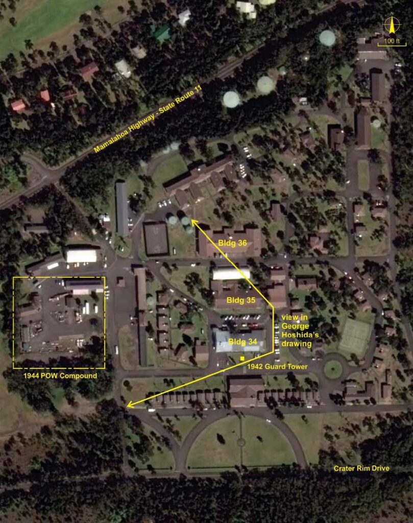
Building 34, now the Crater Rim Café, Lava Lounge and post office, was used as the internee barracks. Building 35, now the recreation center, was built as an enlisted men’s mess hall and converted to a dormitory in 1919. It was used as the internee mess hall in 1943, but became the recreation hall in 1945. (Farrell)

Internee hearings were held in the Federal Building on Waianuenue Avenue in downtown Hilo. Because the hearings lasted several days, it is probable that internees were held overnight at the Old Police Station, on Kalākaua Street and directly across Kalākaua Park from the Federal Building. (Farrell)

By mid-February 1942, the military government determined that under the Geneva Convention interned aliens could not be held in a combat zone.

On February 15, authorities announced that immediate family members could visit. In anticipation of an imminent transfer to another facility, families were advised to bring warm clothes and that each internee could possess $50.

Noting that the internees were not prisoners of war, the authorities soon began the process of relocation to Sand Island or eventual transfer to the continental United States. The first group of 106 internees departed Kīlauea on March 6; the last group of 25 left on May 12. (Chapman)

In all, between 1,200 and 1,400 local Japanese in Hawai’i were interned, along with about 1,000 family members.  By contrast, Executive Order 9066, signed by President Franklin D. Roosevelt on February 19, 1942, authorized the mass exclusion and detention of all Japanese Americans living in the West Coast states, resulting in the eventual incarceration of 120,000 people.

The detainees were never formally charged and granted only token hearings.  Many of the detainees’ sons served with distinction in the US armed forces, including the legendary 100th Battalion, 442nd Regimental Combat Team and Military Intelligence Service.

Following the departure of Japanese inmates in 1942, in June 1944, an addition to KMC was built on the west side, in the area that is now the motor pool. These facilities would serve as a prisoner of war (POW) camp for Koreans and Okinawans who had been brought to the US from islands captured from the Japanese. (Moniz Nakamura)

Military authorities assigned the POWs to maintenance work around the camp. The prisoners generally worked without supervision, mostly on landscape projects and other maintenance work. (Chapman)

The current chain link fence around Tours & Transportation (Bldg 84), Housekeeping (Bldg 81) and Fire & Paramedic Services (Bldg 59) follows the same footprint as the outer wire of the POW camp enclosure. (KMC Walking Tour Narrative)

© 2021 Ho‘okuleana LLC

Filed Under: Military Tagged With: Japanese, WWII, Kilauea Military Camp, Internment, KMC

December 7, 2021 by Peter T Young Leave a Comment

1st Big Ships into Pearl Harbor

Over the years, the face of Pearl Harbor has changed dramatically. When the first Westerner, British seafarer Captain James Cook, came to the islands in 1778, a coral reef barred the entrance of the place known as Wai Momi, making it unsuitable as a port for deep-draft shipping. At that time, nearby Honolulu Harbor was an infinitely more hospitable destination.

It wasn’t until 1826 that the US Navy had its first contact with the Hawaiian Islands, when the schooner USS Dolphin sailed into port. After that, it took more than 13 years for the Navy to begin to recognize the potential of Pearl Harbor.

During a routine survey of the area in 1840, an enterprising naval officer determined that the deep inner harbor could be accessed by completely removing the obstructing reef.

Despite gaining exclusive rights to Pearl Harbor in 1887, the US did not make any attempt to take advantage of their claim on this strategic estuary until well after the turn of the century.

It wasn’t until the capture of Manila during the Spanish-American War, when the US needed to establish a permanent way station in the Pacific to maintain control of the Philippines.

Then, for the first time, the American government began to understand the strategic importance of O‘ahu. Annexation soon followed, but even then, little was done to fortify the area or capitalize on the vast potential of Pearl Harbor.

Finally, beginning in 1902, the entry channel was dredged, deepened, and widened to clear an opening at the entrance of the Harbor. Congress did not officially create a naval base at Pearl Harbor until 1908. (NPS)

“Cutting the channel through the reef that has for so many years closed Pearl Harbor to navigation, is a task so quietly and withal so speedily done, that half the people of Honolulu have come to think of the great work in that section of the island as a part of the day’s routine.”

“What effect this new harbor will have on the future events of the world no one can exactly forecast. But we do know that this harbor will be a pivotal point about which great incidents of the world’s history will revolve.”

“Pearl Harbor will be the assembling place for great fleets of warships. Let us hope that never during the present century will these fleets be called upon to go forth to battle, but whether they do or not, may they at all times be the barrier of protection for an ever-increasing American influence and an ever-expanding American commerce carried in American merchant ships.” (Evening Bulletin, December 14, 1911)

“Upon the completion of the dredging operations of Pearl Harbor bar, December 14, 1911, an official entry into the lochs was made by Rear Admiral Thomas in the flagship California, Captain Harlow, and the occasion of joyful recognition of the important event, the end of a great work.” (Thrum, 1912)

On board the California on December 14, 1911 was the first and last President of the Republic of Hawaii Sanford Dole, and Queen Lili‘uokalani the last monarch of the Kingdom of Hawaii. (Neuman)

“The Queen is delighted over the prospect of a trip on the flagship and is looking forward with deep interest to seeing the waterway really open to the navigation of big ships of war, for it was during the reign of her brother, King Kalākaua, that the cession of Pearl Harbor to the United States was made by treaty.” (Pacific Commercial Advertiser, December 13, 1911; Van Dyke)

“Queen Lili‘uokalani, accompanied by, Colonel ʻIaukea, Mrs ʻIaukea and Mr and Mrs ED Tenney, arrived shortly after 9 o’clock. Her Majesty looked well and seemed to take an eager interest in the proceedings. She was met at the head of the gangway by Admiral Thomas, who graciously took the aged hand and assisted her on to the deck of the warship.”

“The queen was led to a seat, and then the officers of the man-of-war and the guests were presented to her. The queen chatted of the trip about to be taken and contrasted it with some she had made to Pearl Harbor many years ago.” (Hawaiian Star, December 14, 1911)

Also along for the ride was Sun Fo, eldest son of Sun Yat-Sen – who eventually lead the revolution in China which ended two-thousand years of imperial rule. Sun Yat-Sen would be elected the first President of the Republic of China two weeks later on December 29. (Neuman)

The USS California transited the channel entrance to Pearl Harbor and effectively opened the historic port to the world. The ship that took center stage on that morning should not be confused with the battleship California, or BB-44, which found herself on Battleship Row in 1941.

This California was an armored-cruiser weighing in at about 14,000 tons and laden with eight, six and three-inch guns. Her entrance into Pearl Harbor was historic because she was the first large warship to enter the harbor following extensive dredging of the channel. (Neuman)

From the early days of the 20th century, it was clear that Japan was taking her place as a world power. This shift led the US to move a significant portion of her naval forces to the Pacific. Pearl Harbor was a focal point of the transition, becoming the home port for much of the Pacific Fleet.

And so the pieces of this historic puzzle came together. In a matter of time, the very action taken to protect America from this potential threat would be the thing that made her vulnerable to it.

Throughout its history, Pearl Harbor has been revered as a place of great value. In the beginning, it physically yielded sustenance for the Hawaiian people. Later, it empowered America to conquer her enemies.  (NPS)

Japan’s method of declaring war on the US was a four-wave air attack on installations in Hawaiʻi on the morning of December 7, 1941. It was executed in what amounted to five phases.

Phase I: Combined torpedo and dive bomber attack lasting from 7:55 am to 8:25 am; Phase II: Lull in attacks lasting from 8:25 am to 8:40 am; Phase III: Horizontal bomber attacks between 8:45 am to 9:15 am; Phase IV: Dive bomber attacks between 9:15 am and 9:45 am and Phase V: General attack. Raid completed at 9:45. (Maj Gen Green)

© 2021 Hoʻokuleana LLC

USS-California-Pearl Harbor-Dec 14, 1911
Queen Liliuokalani seated in the front row-ceremony of 1st major ship to enter Pearl Harbor-1911
Pearl Harbor-PP-66-4-003-00001
Pearl Harbor Dredging-PP-66-4-015-00001
Pearl Harbor-Luke Field-Ford Island-PP-66-5-016-00001-1924
California at anchor Pearl Harbor-Dec 14, 1911
Pearl Harbor-PP-66-5-005-00001-1920s
Pearl Harbor-PP-66-4-004-00001-1911
USS California - Pearl Harbor-Dec 14, 1911
USS California – Pearl Harbor-Dec 14, 1911
USS California being escorted into Pearl Harbor-Dec 15, 1911

Filed Under: General, Ali'i / Chiefs / Governance, Military, Place Names, Prominent People, Sailing, Shipping & Shipwrecks Tagged With: Queen Liliuokalani, Pearl Harbor, Sanford Dole, Sanford Ballard Dole, Hawaii, Liliuokalani

December 4, 2021 by Peter T Young 2 Comments

Evacuation Camps and War-time Housing

In pre-war preparations, a May 23, 1941 article in the Honolulu Advertiser titled “Army Maps Areas to Be Evacuated in Event of Emergency” informed civilians that 86,000 persons living in Honolulu resided in danger zones, and that half would have to evacuate in the event of a war.

“The Hawaiian Department has worked out a comprehensive plan for moving and caring for those who would have to leave their home.  Preparation of the plan was directed by Col. Albert B. K. Lyman department engineer.”

“Much of the responsibility for the actual mechanics of the process would devolve upon the civilian government unless it was necessary to invoke martial law …”

“… but it is hoped that the people of Honolulu would be sufficiently aware of the necessities of the evacuation process to act voluntarily and cooperate with the government and the army, both in caring for themselves and in helping to care for others.”

“Areas to be evacuated are those places surrounding and in the vicinity of legitimate targets for an enemy. They extend practically without a break along the waterfront from Middle street to Waialae golf course.”

“The mauka boundary is School street to Kapiolani street, then Kapiolani boulevard and the Ala Wai to the fair grounds, along Kapahulu to Waialae avenue, and along the ewa boundary of the golf course to Kahala avenue.”

“This portion of the city that would be evacuated contains several artillery posts, the docks, the oil tanks, railroad yards, Hawaiian Electric Company, Honolulu Gas Company, Mutual Telephone Company, the newspaper plants and the major traffic arteries – all legitimate targets.”

“Because any air raid on Honolulu that might ever occur would most probably be at night, consequently not of the precision variety, bombs might land at some distance from the actual targets. That is the reason so large an area would have to be evacuated.”

“There are two classes of evacuees: those who will voluntarily or with slight persuasion leave, and those who must be forced to leave … Persons who cannot be used in any manner in the defense and who are unwilling to leave Honolulu but who can be used directly and indirectly in the defense constitute the seconds class.’”

“In discussing the evacuation program General Short regretted, that Honolulu does not possess one of the most favorable facilities that could be utilized as a camp. That is a large recreation center away from the ocean.  The beaches, he said, do not offer enough foliage for protection from observation.”  (Honolulu Advertiser, May 23, 1941)

During the Fall of 1941 diplomatic relations between the United States and Japan, which had been steadily deteriorating, took a sudden turn for the worse. December 7, 1941 Japan attacked the US at Pearl Harbor.

Shelters for evacuees were built in the valleys of Palolo, Kalihi and Mānoa; however, they were “held in readiness for evacuees in connection with [another] attack.”

Neither Kalihi Valley Camp nor Palolo Valley Camp ever accommodated Islanders displaced after the initial attack on December 7th. A memorandum written in February 1942 confirmed that both Palolo and Kalihi Camps remained unoccupied.

With the coming of World War II Hawaii was confronted with a serious housing shortage, as Honolulu saw an influx of over 100,000 civilian defense workers, while a lack of building materials and laborers brought residential construction to a virtual halt.

Four evacuation camps, which the Office of Civilian Defense had erected in Palolo and Kalihi valleys in case of another Japanese attack, were turned over to the HHA and converted into wartime public housing for several hundred families.

The housing situation became more acute in 1943, as workers continued to come to the islands, and in 1944 the military further compounded the problem by permitting families to join war workers.

The HHA developed public housing areas in Palolo, Kapalama, and Lanikila during 1944 and 1945, and the Federal Public Housing Authority opened Kalihi War Homes with its 248 units in February 1945.

Members of a Congressional subcommittee, which came to investigate Honolulu’s housing situation (in Pālolo and elsewhere) in March 1945, learned of “hot bed apartments” where as many as eighteen men occupied one room in three shifts.

The subcommittee found that adequate housing had not been provided for approximately 60,000 of the 107,679 civilian newcomers who came to Hawaii during the war.

With the conclusion of World War II, the Pālolo School Camp was closed as they were deemed unsatisfactory for occupancy.  The Pālolo Evacuation Camp adjacent to the 362-unit emergency housing project in Pālolo remained in operation.

The Federal Public Housing Authority started to build another 1,000 dwelling units in Manoa, but these were not completed until 1946, after the war was over.

With the conclusion of World War II, three of the evacuation camps, Kalihi Evacuation Camp, Kalihi School Camp, and Palolo School Camp, were closed as they were deemed unsatisfactory for occupancy.

The Palolo Evacuation Camp adjacent to the 362 unit emergency housing project in Palolo remained in operation. (HHF)

© 2021 Hoʻokuleana LLC

Filed Under: General, Military Tagged With: Honolulu, Oahu, WWII, Housing, Evacuation Camp

October 22, 2021 by Peter T Young Leave a Comment

Bombing the River of Fire

Like most Hawaiian eruptions, the eruptive activity was immediately preceded by a swarm of earthquakes, followed by tremor. Mauna Loa (“Long Mountain”) began erupting at 6:20 pm on November 21, 1935.

The eruption started with a curtain of fountains near North Pit within the summit caldera, Mokuʻāweoweo. The vents migrated 2-miles down the northeast rift zone.

During the six days of the main event, fissures opened up along the northeast rift zone of the mountain, fountaining lava 200- to 300-feet into the air.

On November 26, the summit eruption died and the northeast rift activity was reduced to a single vent at the 11,400-foot elevation. A small vent also opened up further below on the north flank of the mountain at the 8,600-foot elevation. (USGS)

Lava flows from Mauna Loa were generally fast-moving and voluminous. Lava moved relentlessly at a rate of five-miles each day; it pooled up between Mauna Kea and Mauna Loa at about where the Saddle Road is situated.

The ponded lava eventually began to follow the lay of the land, a natural drainage … Then, things “got interesting.” Lava was heading directly toward Hilo. (USGS)

Dr. Thomas A Jaggar Jr, the government volcanologist, estimated that the flow would reach Hilo by January 9, 1936. He suggested using dynamite to collapse lava tubes near the source of the flow in order to stop or divert it.

Explosives were first suggested as a means to divert lava flows threatening Hilo during the eruption of 1881. However, Jaggar’s plan of mule teams hiking the explosives up the mountain would take far too long – the lava flows were moving a mile a day.

Guido Giacometti, a friend of Jaggar, had suggested using US Army Air Corps bombers to precisely deliver explosives. Jaggar agreed, and the call was made.

The US Army Air Corps approved, and the mission and plans to strategically bomb Mauna Loa were set into motion. Lieutenant Colonel George Smith Patton was called on to oversee the Army operation. (He’s the same Patton who would go on to WWII fame.)

Lava tubes are cooled and hardened outer crusts of lava which provide insulation for the faster-flowing, molten rock inside. Such a conduit enables lava to move faster and farther.

The theory was bombs would destroy the lava tubes, robbing lava of an easy transport channel and exposing more of the lava to the air, slowing and cooling it further. (BBC)

On December 26, 1935, six Keystone B-3A bombers of the 23d Bomb Squadron and four Keystone LB-6A light bombers from the 72d Bomb Squadron joined the rendezvous circle in the predawn darkness off Diamond Head, and then headed to Hilo.

Jaggar briefed the crews on the methods he had in mind to divert the lava flow. He then flew over the volcano to assess the flows and select the right points for bombing.

8:30 am, December 27, 1935, the first five bombers departed on the bombing mission. (A second flight of five aircraft was planned for the afternoon.) Each plane carried two 300-pound practice bombs (for practice and sighting,) as well as two 600-pound Mk I demolition bombs (355 pounds of TNT each.)

The bombers opened formation and fell into a huge circle for a follow-the-leader dummy run over the target area. They were flying at about 12,500-feet, not far above the 8,600-foot altitude of the volcano’s flows.

As the lead pilot tipped the control column forward for his run he lowered the wheels, so that by the time he neared the clump of koa trees which served as reference point his plane would be moving only a little faster than the 65-mph landing speed.

‘OK?’ he called to his bombardier as they began their climb after passing over the flow. Standard radio-voice procedure was unneeded. … ‘OK,’ the bombardier grunted. (Johnson)

Five of the twenty bombs struck molten lava directly, most of the others impacted solidified lava along the flow channel margins; one of them turned out a dud.

“Colonel William C Capp, a pilot who bombed the lower target, reported direct hits on the channel, observing a sheet of red, molten rock that was thrown up to about 200′ elevation and that flying debris made small holes in his lower wing.”

“Bombs that impacted on solidified, vesicular pāhoehoe along the flow margin produced craters averaging 6.7-m diameters and 2.0-m depth….” (Swopes)

“Pilots observed that several bombs collapsed thin lava tube roofs, although in no case was sufficient roof material imploded into the tube to cause blockage.”

Jagger wrote that “the violent release of lava, of gas and of hydrostatic pressures at the source robbed the lower flow of its substance, and of its heat.”

The lava stopped flowing on January 2, 1936. The effectiveness of the lava bombing is disputed by some volcanologist. (USGS)

Here’s a link to a video of the Army bombing runs in 1935. (Lots of information here from Army, USGS, hawaii-gov, 4GFC, Johnson, Lockwood & Torgerson, Swopes and This Day in Aviation History.)

http://www.criticalpast.com/video/65675069574_bomb-Mauna-Loa_divert-lava_Keystone-B-3A_Keystone-LB-6A_United-States-fliers

© 2021 Hoʻokuleana LLC

Bombing Run Mauna Loa Volcano (1940)
Three Keystone B6As of 20th Bombardment Squadron, 2d Bomb Group, release their bombs on a practice mission
Thomas_Augustus_Jaggar_Jr
Plume from a test bombing of an old lava flow on Mauna Loa, performed in 1975
Lieutenant General Patton in 1935, prior to World War II
Keystone B-3A Bomber of the type used in the bombing of the volcano above Hilo in 1935
HighFlight-VolcanoBombing
George_S._Patton_1919
Dr. Thomas Jaggar and wife, Isabel Maydwell – 1917
An unexploded bomb on Mauna Loa-1942
Advancing lava flow, December 1935. (USGS)

© 2015 Hoʻokuleana LLC

Filed Under: Military, Prominent People Tagged With: Hawaii Island, Hilo, Lava Flow, Mauna Loa, Thomas Jaggar, Volcano, Hawaii, Eruption, George Patton

May 26, 2020 by Peter T Young 2 Comments

The Hole

Fear of a repeat-attack on Pearl Harbor prompted the Army and Navy to plan a less vulnerable, bomb-proof complex, designed and built as an underground open bay with floor space for an aircraft assembly and repair plant.

Construction on the $23-million underground complex began in 1942 and was completed in late-1944. It was a free-standing structure that was later covered with 5-feet of soil for pineapple cultivation.

It was in immediate proximity to Wheeler Army Airfield and Waieli Gulch Field.  (While Wheeler remains an active military facility, Waieli Gulch Field only lasted through the war – however, remnants of the runway can still be seen.)

The secret underground facility was constructed as an open bay area, without interior cement blocks. The outer walls are composed of reinforced concrete and dirt.

The entrance was placed in the steep side of the gulch to obscure visibility; access to the structure was by means of a quarter-mile-long tunnel.  The access was built on a curve with a 90-degree bend, intended to provide protection for the entrance to the bunker, at the end of which were elevators for the different levels.

It was nicknamed the “Kunia Tunnel” or simply, “The Hole.”

It is not a true tunnel; rather, a freestanding 3-story structure with approximately 250,000 square feet in overall size with a total of three floors.  220,000-square feet were available for assembly of folded winged aircraft (each floor was the equivalent of a football field,) with 30,000-square feet used for power generation and air conditioning.

The main shop was designed to provide space for three B-17 planes, two without wings and one with wings and was later modified to accommodate larger bombers.  The work area was surrounded by smaller repair shops and storage rooms.  To light the facility, it took almost 5,000 fluorescent tubes.

Two elevators serviced the field station – one capable of accommodating four 2 1/2-ton trucks or “an average size four-room cottage.”  For passenger service, another elevator was provided with a carrying capacity of 20-people.

It had a cafeteria that could turn out 6,000-meals a day. Huge air conditioning and ventilating systems ensured a constant flow of fresh air drawn from the open countryside.

One World War II soldier described the tunnel as “the great underground cavern”. The soldier said the tunnel was “equipped with every modern facility and the three floors of the huge bombproof structure were found to be ideal for our purpose”.

Aircraft including the B-24s, B-17s, B-26s bombers and other types were serviced in the bunker; these bombers were used in major bombing operations in the Mariana Islands, the Philippines, Japan and Okinawa.  There is no historical evidence to suggest the field station was ever used for aircraft assembly.

After the danger of further enemy attack passed, this facility housed the Engineers’ extremely important map and chart reproduction services.

It provided personnel, information and communications support to the Pacific Theater and National warfare requirements; working with photographs supplied by Army and Navy fliers, they produced maps and aerial photographic mosaics.

These first “Kunians” were shift workers, working three, 8-hour shifts, making maps. They produced a staggering number of maps; in one month, more than 2,700,000-maps were printed and used by Allied forces in the war in the Pacific.

At the end of WWII, the facility was turned over to the Air Force.  Then, in 1953, the US Navy officially took over the facility and used it for ammunition and torpedo storage; they then renovated it and converted the building into a secret security structure.

With renovations completed in the early-1960s, the Commander in Chief of the Naval Pacific Forces used Kunia as a command center.  Further renovations to strengthen the structure against chemical and radioactive attacks were completed in the mid-1960s. The Fleet Operations Center was moved to another location in 1976, and the Kunia base was turned over to the General Services Agency.

January 1980, it became Field Station Kunia under Army control and later renamed the Kunia Regional Security Operations Center (KRSOC) to reflect the change to a more “joint” mission, with Army, Navy, Air Force and Marines assigned to the unit.  It also hosted the other members of the “Five Eyes” (US, Great Britain, Canada, Australia and New Zealand.)

A state-of-the-art Hawaiʻi Regional Security Operations Center (HRSOC) was constructed near Wahiawa, which replaced the Kunia Regional Security Operations Center (KRSOC).

It is now known as NSA/CSS Hawaiʻi, an intelligence receiving hub for the National Security Agency; much of what goes on at Kunia is top secret.   (Lots of information from the Army, Navy and Marines websites.)

Follow Peter T Young on Facebook 

Follow Peter T Young on Google+ 

Follow Peter T Young on LinkedIn  

Follow Peter T Young on Blogger

© 2020 Hoʻokuleana LLC

The Hole-Kunia - entrance
Entrance to Underground NSA-Naval Security Group Kunia Regional Security Operations Center
The Hole - Kunia - entrance
Entrance to The Hole - Kunia
Entrance to The Hole just above helipad - Kunia
Entrance to The Kunia Tunnel
Entrance-Underground NSA-Naval Security Group Kunia Regional Security Operations Center
Entrance-Underground_NSA-Naval Security Group Kunia Regional Security Operations Center
Kunia Google Earth
Kunia NSGA Hawaii-patch
Kunia RSOC-coin
Kunia-(ronartis)
NSA-CSS Hawaii Regional Security Operations Center-that replaced the Elephant Cage-GoogleEarth
The_Hole - Kunia - entrance
Uses over The Hole - Kunia
Waiele Gulch Airfield under construction-July_9,_1942
Waieli and Wheeler_1948
Waieli Gulch runway
Waieli_Gulch runway
Waieli_runway_construction_1942
Wahiawa_Kipapa_area-map
B-17
B-24
B-26
Wheeler and Waieli 2004

Filed Under: Military Tagged With: Kunia, Kunia Tunnel, Waieli Gulch Field, Hawaii, Oahu, Wheeler Army Airfield

  • « Previous Page
  • 1
  • …
  • 18
  • 19
  • 20
  • 21
  • 22
  • …
  • 44
  • Next Page »

Images of Old Hawaiʻi

People, places, and events in Hawaiʻi’s past come alive through text and media in “Images of Old Hawaiʻi.” These posts are informal historic summaries presented for personal, non-commercial, and educational purposes.

Info@Hookuleana.com

Connect with Us

  • Email
  • Facebook
  • LinkedIn
  • Twitter
  • YouTube

Recent Posts

  • ‘Kakela me Kuke’
  • Aliʻiolani Hale
  • Hotel Del Coronado
  • “This does not look like me”
  • ‘Aim High to Reach the Heaven’
  • Presidents’ Day
  • Moku Manu

Categories

  • Hawaiian Traditions
  • Military
  • Place Names
  • Prominent People
  • Schools
  • Sailing, Shipping & Shipwrecks
  • Economy
  • Voyage of the Thaddeus
  • Mayflower Summaries
  • American Revolution
  • General
  • Ali'i / Chiefs / Governance
  • Buildings
  • Missionaries / Churches / Religious Buildings

Tags

Albatross Al Capone Ane Keohokalole Archibald Campbell Bernice Pauahi Bishop Charles Reed Bishop Downtown Honolulu Eruption Founder's Day George Patton Great Wall of Kuakini Green Sea Turtle Hawaii Hawaii Island Hermes Hilo Holoikauaua Honolulu Isaac Davis James Robinson Kamae Kamaeokalani Kameeiamoku Kamehameha Schools Lalani Village Lava Flow Lelia Byrd Liberty Ship Liliuokalani Mao Math Mauna Loa Midway Monk Seal Northwestern Hawaiian Islands Oahu Papahanaumokuakea Marine National Monument Pearl Pualani Mossman Quartette Thomas Jaggar Volcano Waikiki Wake Wisdom

Hoʻokuleana LLC

Hoʻokuleana LLC is a Planning and Consulting firm assisting property owners with Land Use Planning efforts, including Environmental Review, Entitlement Process, Permitting, Community Outreach, etc. We are uniquely positioned to assist you in a variety of needs.

Info@Hookuleana.com

Copyright © 2012-2024 Peter T Young, Hoʻokuleana LLC


Loading Comments...