Images of Old Hawaiʻi

  • Home
  • About
  • Categories
    • Ali’i / Chiefs / Governance
    • American Protestant Mission
    • Buildings
    • Collections
    • Economy
    • Missionaries / Churches / Religious Buildings
    • General
    • Hawaiian Traditions
    • Other Summaries
    • Mayflower Summaries
    • Mayflower Full Summaries
    • Military
    • Place Names
    • Prominent People
    • Schools
    • Sailing, Shipping & Shipwrecks
    • Voyage of the Thaddeus
  • Collections
  • Contact
  • Follow

May 21, 2023 by Peter T Young Leave a Comment

West Loch Tragedy

Despite its moniker, “Large Slow Target,” the ‘Landing Ship, Tank’ (LST) was an important naval vessel created during World War II to support amphibious operations by carrying significant quantities of vehicles, cargo and landing troops directly onto an unimproved shore.

An LST, 382-feet long and 50-feet wide, carried a crew of 8-10 officers and 115 enlisted men; in addition, there were berths for over 200-troops and a capacity to carry a 2,100-ton load of tanks, trucks, jeeps and weapon carriers and associated munitions and supplies.

1,051 LSTs were constructed and used in the war effort; they were used in the Atlantic and the Pacific.  Only 26 were lost in WWII due to enemy action.

However, in Hawaiʻi, a once secret and often-forgotten tragedy struck at Pearl Harbor, in 1944.

At the time, the Allied forces were preparing for two assaults – one was in the Atlantic (D-Day, June 6, 1944 – nearly 200,000-Allied troops on 7,000-ships and more than 3,000-aircraft headed toward Normandy, France.)

The other was in the Pacific (Saipan, June 15, 1944 – more than 300-landing vehicles put 8,000-Marines on the west coast of Saipan; eleven support ships covered the Marine landings.)

In preparation for the Saipan assault, in late-May, crews were loading ships at the US Pacific Fleet base at West Loch, Pearl Harbor.

(Pearl Harbor is divided into a series of lochs that fan out from Ford Island that sits in the center of harbor. West Loch was the staging area for the invasion fleets of the Pacific.)

29-LSTs, plus a variety of other amphibious vessels that would support the initial landings and follow-on operations, were tightly clustered while their hulls and decks were being filled with ammunition, supplies and other material.

That list of items included munitions of all calibers and types, propellants, aviation gasoline, vehicle fuel and a variety of other volatile cargoes.

Nested beam-to-beam at piers off of Hanaloa and Intrepid Points opposite Lualualei (now known as Naval Magazine Pearl Harbor) were six compact rows of LSTs and other craft moored at “Tare” piers jutting into the adjoining waters of West Loch and Walker Bay.

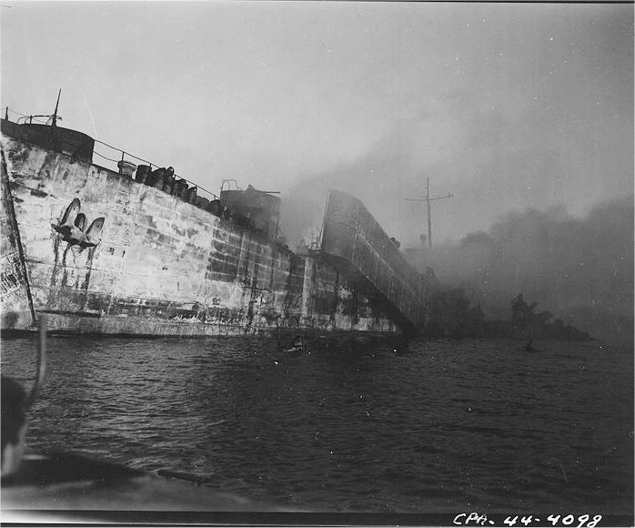
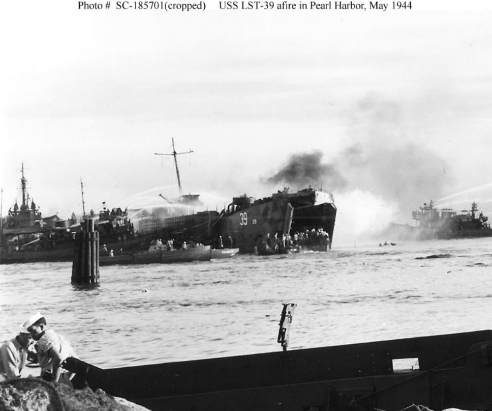
At 1508 (3:08 pm) May 21, 1944, Lualualei’s tranquility was shattered by a deafening explosion which thundered across most of Oʻahu.

Without warning, an enormous mushroom of orange black fire encapsulated LST-353 at Tare 8, obliterating it and most of the seven other ships from view as the giant fireball burst into the cloudless sky.  (Oliver)

The explosions continued, damaging more than 20 buildings shoreside at the West Loch facility. For 24-hours fires raged aboard the stricken ships.  (NPS)

Had the Japanese struck again – another sneak attack on Pearl Harbor? … No one knew.

Then the ground shook to a second blast. Earthquake?  Volcano?  Aerial bombs?  Alarms rang as another shattering blast of even greater magnitude jolted the air.  (Oliver)

Predictably, flaming gasoline and exploding ammunition soon began to take a frightful toll of the Soldiers, Sailors and Marines loading and manning the ships.

Fires and explosions drove back ships and craft engaged in firefighting efforts, each time those vessels re-entered the inferno to contain the fires and keep the disaster from spreading to the rest of the Fleet anchorage. (USNavalInstitute)

Several investigations sought to find the reason for such a disaster, but no conclusive evidence as how it occurred was decided upon.  Two major causes emerged as most likely: Either a fused mortar round was accidently dropped while unloading the LCT aboard LST-353, or the initial explosion was caused by gasoline vapors.  (Oliver)

The Navy put a “Top Secret” status on the tragedy.  Survivors and eyewitnesses to the calamity were warned under threat of prosecution not to make any mention of the disaster in letters or calls to family members. To the outside world the tragedy at West Loch simply never happened.  (Oliver)  (It was declassified in 1960.)

The total casualties were 392 dead; 163 sailors, the rest young Marines from the newly formed 2nd and 4th Marine Divisions, and 396 injured – eight ships were lost.

It was recommended that LSTs no longer be nested, so that disaster like that at West Loch could be avoided. Fleet Admiral Chester Nimitz disagreed. He felt that facilities were too limited at Pearl and that the nesting was necessary. “It is a calculated risk that must be accepted.”  (NPS)

Despite the losses, the Saipan invasion force put to sea as scheduled on June 5, 1944, just as the largest invasion armada ever to sail was crossing the English Channel en route to the Normandy beaches.

On June 15, 1944, during the Pacific Campaign of World War II (1939-45,) Admiral Turner was in charge of the assault on Saipan.  At 05:42, his orders came – “Land the landing force.” In position, about 1,250 yards from the line of departure, 34-LSTs moved into line. Two huge doors on the bow of each ship opened and dropped their ramps into the water. (BattleOfSaipan)

US Marines (having earlier trained at Camp Tarawa, Waimea, Hawaiʻi Island and Camp Maui, Ha‘ikū, Maui) stormed the beaches of the strategically significant Japanese island of Saipan, with a goal of gaining a crucial air base from which the US could launch its new long-range B-29 bombers directly at Japan’s home islands.

Facing fierce Japanese resistance, Americans poured from their landing crafts to establish a beachhead, battling Japanese soldiers inland and forcing the Japanese army to retreat north. Fighting became especially brutal and prolonged around Mount Tapotchau, Saipan’s highest peak, and Marines gave battle sites in the area names such as “Death Valley” and “Purple Heart Ridge.”  (history-com)

This was the first action of Operation Forager, the conquest of the Marianas, consisting of two Marine Divisions, a US Army Division, and the required force and support units from an amphibious armada of nearly 600-ships and craft.

When the US finally trapped the Japanese in the northern part of the island, Japanese soldiers launched a massive but futile banzai charge. On July 9, the US flag was raised in victory over Saipan.  (history-com)

© 2023 Hoʻokuleana LLC


Filed Under: Military Tagged With: West Loch, Hawaii, Oahu, Pearl Harbor, LST

February 8, 2023 by Peter T Young Leave a Comment

Currency Stamped with “HAWAII” during WWII

Like most people of his generation, my father saved stuff, especially “special” stamps, currency and coins – below is a $10 bill of his that he gave to me.
 
According to the Federal Reserve, with the start of World War II, the US started printing specialized military currency to provide economic stability for the US dollar in occupied countries.
 
In Hawaiʻi, the Treasury Department replaced all US currency with special issue notes as a precautionary measure in the event of a Japanese victory.
 
These notes were circulated only in Hawai‘i and their brown seals and serial numbers differentiated them from notes issued on the mainland.
 
Overprints of the word HAWAII were made; two small overprints to the sides of the obverse of the bill between the border and both the treasury seal and Federal Reserve Bank of San Francisco seal, and huge outlined HAWAII lettering dominating the reverse.
 
The hope was that, should there have been a Japanese invasion, the US Government could immediately declare any Hawai‘i-stamped notes worthless, due to their easy identification.
 
$1, $5, $10 and $20 San Francisco Reserve notes featured the seal and serial numbers that the Bureau of Engraving and Printing called the “Hawaiʻi Overprint” (from July 1942 until October 1944.)
 
Hawai‘i wasn’t the only place where special currency was distributed.  Similarly, special notes were issued for use by American troops during the invasion of North Africa in November 1942.
 
These notes were overprinted with distinctive yellow Treasury Seals to distinguish them from the regular Silver Certificates overprinted with blue seals.
 
Like the overprinted Hawai‘i notes, these distinctive certificates could be declared worthless if large amounts fell into enemy hands.
 
In addition to the Hawai‘i currency issued, the Bureau of Engraving and Printing produced or oversaw the private production of Allied military currency used in Italy, France, Austria, Germany and Japan during and after the war.
 
The Department of the Treasury redeems all genuine United States currency at face value only, and does not render opinions concerning the numismatic value of old or rare currencies.
 
However, numerous websites indicate premiums are being paid for these special bills.  (I am keeping mine as a reminder of my father.)
 
© 2023 Ho‘okuleana LLC

Filed Under: Military Tagged With: Hawaii, WWII, Currency

February 1, 2023 by Peter T Young Leave a Comment

Raising the United States Flag

A Command from Captain Wiltse to Lieutenant Commander Swinburne; USS Boston, Honolulu, Hawaiian Islands, February 1, 1893 …

“Sir: You will take possession of the Government building, and the American flag will be hoisted over it at 9 am. Very respectfully, GC Wiltse, Captain US Navy, Commanding USS Boston.”

The following is a summary of a report prepared by Lieut. Commander Swinburne in preparation and response to that order and the events that followed (as recorded in the Report of the Committee of Foreign Relations, United States Senate, 1894.)

In accordance with that order, the battalion of the Boston landed at Brewers Wharf, in the city of Honolulu, at 5 pm January 16.

The following summarizes the forces that landed: Company A, Artillery, 40 men; Company B, Infantry, 35 men; Company C, Infantry, 34 men; Company D, Marines, 30 men;  Color guard, 4 men; hospital corps, 1 apothecary, 4 stretchermen; signalmen, 2; music, 3. Total, 153 men, 11 officers.

Each man carried the regulation knapsack, with blanket and change of clothing, haversack with mess gear and ration of hard bread, and filled canteen. Those armed with Lee rifle wore the double webbing belt carrying 60 cartridges in the loops and 20 in magazines. The marines were fitted out with the same belts, but the loops only were filled.

The ammunition boxes of the Gatling gun contained four filled Accle’s Feeds and 1,380 extra rounds of .45 caliber in pasteboard boxes. The ammunition boxes of the 37 mm contained 64 cartridges, common shell. Reserve ammunition in 37 mm. caisson was as follows: After compartments, 112 37 mm. cartridges, common shell; forward compartment 1,600 caliber .45 cartridges in pasteboard boxes; top or center compartment, four filled Accle’s Feeds, and 800 .38 caliber revolver cartridges.

After the battalion was formed, they marched first to the United States consulate, where Lieut. Draper, with his company, was detached with orders to proceed to the legation and leave half his command in charge of the orderly sergeant, returning with the remainder to the United States consulate, himself, and remain there as a guard until further orders.

The remainder of the battalion then marched down King Street. In passing the palace the battalion, in column of companies, gave a marching salute, trumpeters sounding four ruffles in honor of the royal standard, which was flying there.

On arriving at the residence of Mr. JB Atherton, an American, the command was halted, and permission having been obtained, was marched into the grounds, arms stacked and ranks broken.  About 8 in the evening the battalion marched to Arion Hall and camped there.

During the night the men were kept ready for an instant’s call, but there were no disturbances of any kind.

At reveille the next morning, 17th, the camp routine was published and has been strictly carried out in all its details. Latrines were built in the yard and every sanitary precaution taken.

At 2:30 pm, a civilian, armed, reported that a policeman had been shot while attempting to stop a wagonload of ammunition which was being conveyed to the old armory where the civilian forces enrolled by the committee of safety were then assembling, and that a large crowd was collecting on Merchant Street.

The battalion was immediately assembled under arms in the yard in rear of the building to await developments. Until nearly 6 o’clock, the men leading the citizens’ movement had assumed charge of the Government building without opposition of any kind; the civilian companies under arms had marched in and established a line of sentries about the Government building.

The Boston’s battalion was kept in rear of the camp, at their company parades, with arms stacked. About 1 pm, they were notified that a Provisional Government, of which Mr. SB Dole was presiding officer, was in complete possession.  A letter from the United States minister recognized it as the de facto government of the Hawaiian Islands, and the battalion was to consider it as such.

During the night, again, officers and men were kept ready for a moment’s call, but the city was perfectly quiet.

During the day of the 18th the royal standard was hauled down over the palace, and the household troops disbanded, by order of the Provisional Government, except a small guard of honor, who accompanied the ex-Queen to her residence on Beretania street.

On January 19 new quarters were provided for the battalion at the unoccupied house on King street, the property of Mr. CR Bishop.  Having thoroughly policed the old camp, the battalion moved into the new quarters at 1:30 pm.  Daily routine followed.

In accordance with verbal orders given the evening of January 31, the battalion was paraded on the morning of February 1, at 8:30, in front of the quarters – ‘A’ Company as artillery with Gatling and 37 men; the rest as infantry in light marching order.

As the line was formed, a written order, dated February 1, was given; in obedience to those orders the battalion marched to the Government building, where we were received by the civilian troops, who presented arms as they entered. President Dole and all members of the ministry and advisory council were also present.

According to the order, Col. Sofer, Commander in Chief of the Provisional Government forces, at once turned over the custody of the building to Lieut. Commander Swinburne.

A proclamation from Minister Stevens establishing a protectorate over the Hawaiian Islands in the name of the United States, pending negotiations with the Hawaiian Commissioners at Washington, was read.

At 9 am, the United States ensign was hoisted over the building, the battalion and civilian forces presenting arms.  The Hawaiian flag, hoisted on the pole in the grounds, received the same salute.

The civilian forces of the Provisional Government were then withdrawn and the custody of the building turned over to Lieut. Draper with his company of 25 marines, which were withdrawn from the United States consulate for the purpose, the guard at the United States legation being continued but reduced to 5 men. The blue jacket companies of the battalion then returned to their quarters.

© 2023 Hoʻokuleana LLC

Filed Under: Ali'i / Chiefs / Governance, Military Tagged With: Arlington Hotel, Wiltse, C Brewer, Atherton, Arion Hall, Camp Boston, Hawaii, Charles Reed Bishop

January 2, 2023 by Peter T Young Leave a Comment

Pacific Jungle Combat Training Center

Prior to World War II, Kahana and Punalu‘u Valleys were primarily used for agricultural activities.  Taro, rice, and sugar cane were cultivated at the mouths of each valley.  The interior portions of the valleys were heavily vegetated and relatively unused.

The Army initially leased 485.25 acres in Kahana Valley from Hui of Kahana in November 1944, retroactive to May 1943.  Between 1943 and 1947, the Army acquired an additional 1,781.52 acres in the neighboring Punalu‘u Valley from various landowners through leases, licenses, and permits.

In response to an August 9, 1943 directive from the Commanding General, Hawaiian Department, Pacific Jungle Combat Training Center (CTC) was established as a school on Oahu to supplement Department Ranger and Combat School training.

It was located on the northeastern side of the island of Oahu totaling approximately 2,545 acres in the adjacent valleys of Punalu‘u and Kahana in the district of Ko‘olauloa.

Pacific Jungle CTC was also known as Unit Jungle Training Center, Unit Combat Training Center, Pacific Combat Training Center, Jungle Training, Punaluu Training Camp and Green Valley Jungle Training Camp.

Punalu‘u Valley being referred to as “Green Valley” by the Army while Kahana Valley was designated “Red Valley” during utilization of the valleys as a training area.

An Army-built coral-surfaced service road is still referred to as “Green Valley Road” by area residents. This road is also designated by Oahu Civil Defense Agency as an evacuation route to allow coastal inhabitants access to higher ground in the event of a tsunami.

Beginning in September 1943 (during World War II), this property was used as a unit-level jungle combat training center.  The Center was divided into three courses: Red, Blue, and Green.

Basic warfare training was conducted at the Red and Blue courses while advanced warfare training and Instructor Jungle Training School were conducted at the Green course.

Subjects taught during a one-week course included jungle first aid and evacuation, hand-to-hand combat training, construction and passage of wire entanglements, booby traps, patrolling and ambushing, assault of Japanese fortified areas, combat reaction proficiency, and jungle living.

The Army reportedly constructed Japanese villages and pillboxes for training purposes.  Temporary barracks, a mess hall, a bakery, and shower facilities were also erected though no longer exist.

Advanced training on Green Course was discontinued on 28 May 1944 after only its second class as it became necessary to utilize the course for basic jungle warfare training of divisions being staged for the Western Carolines operations.

Jungle warfare was de-emphasized as the war progressed from tropical regions to areas where jungle fighting was not a primary consideration.

All jungle training centers became known as Unit Combat Training Centers in March 1945. On month later, it was redesignated as Pacific Combat Training Center to deemphasize jungle warfare.  Over 241,000 men received basic, advance, or instructor training at the center.

Munitions known to have been used or recovered at the site include 75mm armor piercing rounds, 2.36-inch rockets, MKII hand grenades, rifle grenades, 105mm high explosive rounds, 81mm high explosive and practice mortar rounds, and small arms.

Postwar plans called for closing the majority of the center except for the Green Course in Punalu‘u Valley, which was to be retained to fulfill the Army’s postwar training requirements.

The Army re-opened Punalu‘u Valley on April 1, 1946 to provide emergency shelter for area residents displaced by a tsunami.  Tents were erected for sleeping quarters, to render medical treatment, and to feed approximate 1,700 individuals.

Parcels in Kahana Valley were returned to previous landowners in August 1946.  The leases, licenses, and permits for parcels in Punalu‘u Valley terminated between April 1945 and November 1950 and were reverted back to previous owners.

The Punalu‘u Valley parcels are primarily owned by Kamehameha Schools.  The Kahana Valley parcels are now owned by the State of Hawai‘i and managed by the DNLR, Division of State Parks.

The Kahana Valley parcels are located in the Ahupuaʻa ʻO Kahana State Park. The park was established as a “living park” with the primary purpose to nurture and foster native Hawaiian cultural traditions and the cultural landscape of rural windward Oahu.   (All here is from the Army Corps of Engineers.)

© 2023 Ho‘okuleana LLC

Filed Under: Military Tagged With: Punaluu, Kahana, Army, Marines, Navy, Ahupuaa O Kahana State Park, Pacific Jungle Training Center

December 27, 2022 by Peter T Young Leave a Comment

Heʻeia

The nine ahupuaʻa of Kāneʻohe Bay, beginning at the boundary between Koʻolauloa and Koʻolaupoko Districts (west) and moving eastward, are Kualoa, Hakipuʻu, Waikāne, Waiāhole, Kaʻalaea, Waiheʻe, Kahaluʻu, Heʻeia and Kāneʻohe.

The ahupuaʻa of Heʻeia and Kāneʻohe also included portions of Mōkapu Peninsula (Heʻeia runs from the mountains to the sea, but also crosses over a portion of the water in Kāneʻohe Bay and includes a portion of a Mōkapu peninsula across the Bay.)  Heʻeia also includes Moku-o-Loʻe (Coconut Island,) Kahaluʻu includes Kapapa Island and Kualoa includes Mokoliʻi.

The name of the land of Heʻeia is traditionally associated with Heʻeia, the handsome foster son of the goddess Haumea and grandson of the demigod ʻOlopana, who was an uncle of Kamapuaʻa.

Heʻeia was named in commemoration of a tsunami-type wave that washed Haumea and others into the sea – a great tidal wave that “washed (he‘e ‘ia) … out to sea and back” (Lit., surfed, or washed (out to sea,) or swept away.)

They swam until they were exhausted and were finally washed ashore at Kapapa Island in Kāneʻohe Bay. It was the handsome Heʻeia who fell in love with Kaohelo, a younger sister of Pele and Hiʻiaka, whom he met in Koʻolau, Oʻahu.  (Devaney)

In ancient Hawai‘i, fishponds were an integral part of the ahupua‘a food source.  Hawaiians built rock-walled enclosures in near shore waters to raise fish for their communities and families.  Loko iʻa (fishpond) were used for fattening and storing of fish for food and also as a source for kapu (forbidden) fish.  Walled, brackish-water fishponds were usually constructed on the reef along the shore and one or more mākāhā (sluice gate.)

Heʻeia Fishpond’s wall was one of the longest, extending nearly a mile.  As a large pond, it is subject to considerable evaporation, increasing salinity in the pond; as such, fresh water is added.  Heʻeia is somewhat unique in that it has mākāhā gates on the mauka wall to control the flow of fresh water.

Kalo (taro) was a main staple in the diet of nearly all Hawaiians prior to European contact and was extensively cultivated.  As early as 1789, Portlock described this area:

“… the bay all around has a very beautiful appearance, the low land and valleys being in high state of cultivation, and crowded with plantations of taro, sweet potatoes, sugar-cane, etc. interspersed with a great number of coconut trees ….”

The region had a considerable amount of land cultivated in taro up through the early-1800s.  “Southeastward along the windward coast, beginning with Waikāne and continuing through Waiāhole, Kaʻalaea, Kahaluʻu, Heʻeia and Kāne’ohe, were broad valley bottoms and flatlands between the mountains and the sea which, taken all together, represent the most extensive wet-taro area on Oʻahu.” (Handy, Devaney)

The rains that sweep through here have been memorialized in poetry and song.  A traditional mele honoring Kaumuali‘i suggests “the sound of heavy rain drops on dry leaves, or dry thatching of the pandanus leaf, … of the rain accompanying the koʻolau wind, which calms the troubled waters”.

This “heavy-sounding rain” of the Koʻolau has been transformed into a poetical saying, “Ka ua kani koʻo o Heʻeia, The rain of Heʻeia that sounds like the tapping of walking canes”.  (Fornander)

During the early historic times, many of the ruling chiefs favored this area as their place of residence. Kahahana the ruler of Oʻahu sometimes resided there. Kahekili after defeating Kahahana lived in Kailua, Kāneʻohe and Heʻeia.

The Sacred Hearts Father’s College of Ahuimanu was founded by the Catholic mission at Ahuimanu, Heʻeia in 1846.  “Outside the city, at Ahuimanu, Maigret has now a country retreat that he refers to by the Hawaiian word māla.  It is a combination garden, orchard and kitchen garden. …”

“The venerable bishop has built his own vineyard and planted his own orchard … His retreat in the mountain, his “garden in the air” as he terms it, is a pleasant and profitable sight … When the pressure of events allows it, Maigret takes refuge there.” (Charlot)

One of its students, Damien (born as Jozef de Veuster,) arrived in Hawaiʻi on March 9, 1864, at the time a 24-year-old choirboy.  Determined to become a priest, he had the remainder of the schooling at the College of Ahuimanu.  Bishop Maigret ordained Father Damien at the Cathedral of Our Lady of Peace in 1864 and later assigned him to Molokaʻi.  In 2009, Father Damien was canonized by Pope Benedict XVI.

The earliest of the modern large commercial agricultural ventures started with the cultivation of sugar cane in Kualoa in the 1860s. By 1880, three more sugar companies had emerged in Kahaluʻu, Heʻeia and Kāne’ohe. Heʻeia Sugar Company (also called Heʻeia Agricultural Co. Ltd) operated from 1878 to 1903.

In 1880, the region reported 7,000-acres available for cultivation; in 1883 a railroad was installed at Heʻeia, and by the summer of that year it was noted that the railroad had allowed a much greater amount of land to be harvested, even allowing cane from Kāneʻohe to be ground at Heʻeia; however, the commercial cultivation of sugar cane was short-lived.  (Devaney)

Rice cultivation did not occur in earnest until the decline of sugar, and in 1880 the first Chinese rice company started in the nearby Waineʻe area. Abandoned systems of loʻi kalo were modified into rice paddies. The Kāneʻohe Rice Mill was built around 1892-1893 in nearby Waikalua.

Another commercial crop, pineapple, was also grown here, starting around 1910.  By 1911, Libby, McNeill & Libby gained control of land here and built the first large-scale cannery with an annual capacity of 250,000-cans at nearby Kahaluʻu; growing and canning pineapples became a major industry in the area for a period of 15 years (to 1925.)

The US military first established a presence on the Mōkapu peninsula in 1918 when President Woodrow Wilson signed an executive order establishing Fort Kuwaʻaohe Military Reservation (the western portion of Mōkapu is within the Heʻeia ahupuaʻa.)

Today, Marine Corps Base Hawaiʻi continues to serve as a fully functional operational and training base for US Marine Corps forces. The Marine Corps Air Station (MCAS) here operates a 7,800-foot runway (on the ahupuaʻa of Heʻeia) that can accommodate both fixed wing and rotor-driven aircraft.

With World War II underway, the Navy recognized the need to be able to communicate across the Pacific.  In 1942, a group of radio experts determined a superpower radio station with across-the-Pacific range might be built provided that the antenna could be raised high enough above the ground.

The solution was to find a topographic feature that would act like the “unbuildable” tall tower.  Using technology developed pre-World War I, they strategically positioned four Alexanderson Alternators; one was located in Haiku Valley in Heʻeia.  Haiku Valley with its horseshoe shape and sheer side-walls filled the prescription perfectly.

To build it, mountain climbers pounded spikes into the vertical cliff, then added wooden stairs up the mountain.  A lift to haul up materials was added and they strung cables across the valley.  The Alexanderson Alternator radio system, transmitting Morse code across the Pacific, was operational in 3-months.  A reminder of that facility is the Haiku Ladder, Haiku Stairs – the Stairway to Heaven (a 3,922-step ladder/stairway ascending the summit of the Koʻolau mountain range.)

Today, Windward Mall, portions of Windward Community College, Valley of the Temples, Tetsuo Harano Tunnels (H3,) Hawaiʻi Institute for Marine Biology, MCBH, Heʻeia Kea Small Boat Harbor and a bunch of other folks call Heʻeia home.

© 2022 Hoʻokuleana LLC


Filed Under: Military, Place Names, Schools Tagged With: Moku O Loe, Windward, Ahuimanu, College of Ahuimanu, H3, Hawaii, Mokapu, Oahu, HIMB, Haiku, Heeia, Koolaupoko, Marine Corps Base Hawaii

  • « Previous Page
  • 1
  • …
  • 14
  • 15
  • 16
  • 17
  • 18
  • …
  • 45
  • Next Page »

Images of Old Hawaiʻi

People, places, and events in Hawaiʻi’s past come alive through text and media in “Images of Old Hawaiʻi.” These posts are informal historic summaries presented for personal, non-commercial, and educational purposes.

Info@Hookuleana.com

Connect with Us

  • Email
  • Facebook
  • LinkedIn
  • Twitter
  • YouTube

Recent Posts

  • Protecting a Forest, Preserving a Culture
  • Sharing the Spirit of America – SharingTheSpiritOfAmerica
  • Ahahui Hoʻoulu a Hoʻola Lahui
  • Hōkūle‘a Was An Official US Bicentennial Project
  • About 250 Years Ago … E Pluribus Unum – ‘Out of Many, One’
  • 250-Years Ago … Declaration of Independence
  • 250 Years Ago … Comparing American & Hawaiian ‘Declarations’ … and War

Categories

  • Place Names
  • Prominent People
  • Schools
  • Sailing, Shipping & Shipwrecks
  • Economy
  • Voyage of the Thaddeus
  • Mayflower Summaries
  • American Revolution
  • General
  • Ali'i / Chiefs / Governance
  • Buildings
  • Missionaries / Churches / Religious Buildings
  • Hawaiian Traditions
  • Military

Tags

Albatross Al Capone Ane Keohokalole Archibald Campbell Bernice Pauahi Bishop Charles Reed Bishop Downtown Honolulu Eruption Founder's Day George Patton Great Wall of Kuakini Green Sea Turtle Hawaii Hawaii Island Hermes Hilo Holoikauaua Honolulu Isaac Davis James Robinson Kamae Kamaeokalani Kameeiamoku Kamehameha Schools Lalani Village Lava Flow Lelia Byrd Liberty Ship Liliuokalani Mao Math Mauna Loa Midway Monk Seal Northwestern Hawaiian Islands Oahu Papahanaumokuakea Marine National Monument Pearl Pualani Mossman Quartette Thomas Jaggar Volcano Waikiki Wake Wisdom

Hoʻokuleana LLC

Hoʻokuleana LLC is a Planning and Consulting firm assisting property owners with Land Use Planning efforts, including Environmental Review, Entitlement Process, Permitting, Community Outreach, etc. We are uniquely positioned to assist you in a variety of needs.

Info@Hookuleana.com

Copyright © 2012-2024 Peter T Young, Hoʻokuleana LLC

Loading Comments...