As a means of solidifying a site in the central Pacific, the US negotiated an amendment to the Treaty of Reciprocity in 1887. King Kalākaua in his speech before the opening session of the 1887 Hawaiian Legislature stated (November 3, 1887:)
“I take great pleasure in informing you that the Treaty of Reciprocity with the United States of America has been definitely extended for seven years upon the same terms as those in the original treaty, with the addition of a clause granting to national vessels of the United States the exclusive privilege of entering Pearl River Harbor and establishing there a coaling and repair station.”
From 1901 to 1908, the Navy devoted its time to improving the facilities of the 85 acres that constituted the naval reservation in Honolulu. Under the Appropriation Act of March 3, 1901, this tract of land was improved with the erection of additional sheds and housing. The station grew slowly, and not always at an even pace. (navy-mil)
On May 13, 1908, the US Congress affirmed Pearl Harbor’s strategic importance by appropriating funds and authorized and directed the Secretary of the Navy “to establish a naval station at Pearl Harbor, Hawaiʻi, on the site heretofore acquired for that purpose”. (Congressional Record)
Until the transfer of the Naval Station to Pearl Harbor, the naval reservation in Honolulu remained nothing more than a rather elaborate coaling station. The major interests were the shipping and weighing of coal and the checking of invoices. (navy-mil)
Immediate improvements included dredging the entry channel; constructing the necessary infrastructure and other naval facilities; and building a drydock.
Congress further noted that Secretary “may, in his discretion, enter into contracts for any portion of the work, including material therefor, within the respective limits of cost herein stipulated, subject to appropriations to be made therefor by Congress, or may direct the construction of said works or any portion thereof under the supervision of a civil engineer of the Navy.” (Congressional Record)
“A small army of men, looking for work at Pearl Harbor, besieged the Naval Station this morning. … Men, who have been turned away from time to time with the promise that they might find something, when the necessary papers arrived, this morning thronged to the place to get the precious slips. … The men are to be put to work as soon as Washington has been heard from and building at Pearl Harbor begins.” (Evening Bulletin, August 6, 1908)
On December 5, 1908, the newly-formed “Hawaiian Dredging Company of Honolulu was found to have made, the lowest figure of the six bidden ($3,560,000,) which included two Honolulu concerns and four mainland companies.” (Evening Bulletin, December 1, 1908)
Hawaiian Dredging apparently initially intended a partner, “The contract for the dredging of the Pearl Harbor channel… will be handled in a combination with the San Francisco Bridge Company”. (Hawaiian Star, December 18, 1908) However, shortly thereafter, it was noted that Hawaiian Dredging “is now controlled and owned entirely by the Dillingham interests”. (Pacific Commercial Advertiser, December 22, 1908)
“The contract was signed December 24, 1908, and actual dredging operations began March 1, 1909.” (Congressional Record) The period from 1908 to 1919 was one of steady and continuous growth of the Naval Station, Pearl Harbor. (navy-mil)
That leads us to this piece’s title and the focus of this summary – Watertown.
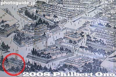
With all the work underway at Pearl Harbor, Hawaiian Dredging created a camp, more like a small city, to house and provide for the workers and their families.
It was called ‘Watertown,’ because of the frequent leaks in its water main, which was installed so hastily that much of it lay above ground. (McElroy) (It was alternatively known as “Dredger’s Row” or “Drydock Row.” (Waller))
It was situated “on the Waikīkī or Honolulu shore of the channel … just below Bishop Point, and mauka of Queen Emma Point (Fort Kamehameha.)” (Pacific Commercial Advertiser; Papacostas)
Watertown was a 2,000-acre settlement containing numerous large structures, roads, rail lines, port facilities and an ethnically diverse population of laborers responsible for the dredging of Pearl Harbor. In the early 1930s the population of Watertown numbered 1,000 laborers and their families, including 300 school-aged children. (McElroy)
The residents were made up of Japanese, Russians, Chinese, Portuguese and a score of Americans who were the employees of the dry-dock, machinists, launch hands, laborers and native Hawaiian fishermen. (Fletcher)
In addition, off-duty inspectors overseeing the dredging operations lived at Watertown in quarters provided by Hawaiian Dredging and ate their meals at a restaurant conducted by Chinese. (While on duty they slept and ate on the dredges which were located from one-half to two miles from shore in the channel.) (Fletcher)
The town included a schoolhouse and adjacent Catholic Church, a theater, post office, at least one hotel and a number of stores and offices.
In addition to housing its resident population, Watertown was noted as a recreation hub for the entire region, complete with gambling, drink and prostitution. (McElroy)
By the early-1930s, Watertown was falling into disrepair and businesses were declining. Demolition began in 1935 and had disappeared by December 11, 1936, when an Army air base (later Hickam Air Force Base) replaced the town (however, the former Watertown school buildings were initially used by the construction crew associated with the Hickam construction.) (Waller)