“A few years ago even the most progressive citizens of the Paradise of the Pacific would state that there was ‘nothing in real estate’ in Honolulu, and every man with money was chasing after sugar stock or doubling his coin in the business which justly, if not politely, must be described as usury.”
” New blood and fresh ideas were wanted to shake up the community from the lethargy in which every body apparently had fallen.” (The Independent, April 25, 1898)
“One day CS Desky arrived on the scene, and it didn’t take him very long before he had realized the wonderful opportunities which the islands offered …. Desky treated the public to surprise after surprise. … The new Progress Block erected by him … deserves a special mention being the best finished and up-to-date building ever seen in Honolulu.” (The Independent, April 25, 1898)
But, wait – that is getting ahead of the story. Let’s look back; in doing so, we’ll see some history related to some familiar Honolulu institutions.
With a growing maritime industry in the Islands, in 1833, the Seamen’s Friend Society sent Rev John Diell to establish a chapel in Honolulu; the Bethel Chapel and the seamen’s chaplaincy were dedicated on November 28, 1833, in a service attended by “the king, Kīnaʻu, and the principal chiefs … together with a respectable number of residents, masters of vessels and seamen.”
As the population of the town continued to grow, it became evident there was a need to form a separate and self-supporting church; so, in 1852, the Second Foreign Church in Honolulu came into existence. In 1856, they built a permanent house of worship at the corner of Fort and Beretania streets and the name of the organization was changed to the Fort Street Church of Honolulu.
The Fort Street English Day School was officially established in 1865; it met in the basement of the Fort Street Church. The Fort Street School was split in 1895 into Kaʻiulani Elementary School and Honolulu High School (the high school moved into Keōua Hale – former residence of Princess Ruth Keʻelikōlani (now the site of the Central Intermediate School.)) (Later (1907,) the Honolulu High School moved again; that year it changed its name to McKinley High School (Oʻahu’s oldest public high school.))
In April 1887, Fort Street Church prepared a proposal to reunite the Bethel and itself into a new organization, and from that time until the formal union, the two churches worshipped together. Selection of the new church’s name was settled by vote; the final result was Central Union 28, Church of the Redeemer 18, and Bethel Union 1.
Thus, Central Union Church began its existence. The original congregation numbered 337 members – 250 from the Fort Street Church, 72 from Bethel Union, 13 from other churches and 2 on confession of faith at the first service. By 1888, increased church membership made it apparent that the Central Union congregation was outgrowing the Fort Street building.
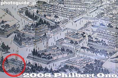
All of these activities (with the Church and School using, then leaving the property) eventually freed up the site at the corner of Fort and Beretania Street (the former home of what are now Central Union Church and McKinley High School.) This is across the Fort Street Mall from the Cathedral of Our Lady of Peace.
Several newspaper articles help explain what happened next. The July 27, 1897 issue of the Hawaiian Gazette starts it off with a front page headline reading, “Progress Block.”
“Plans have just been completed at the offices of Ripley & Dickey (Clinton Briggs Ripley and Charles William “CW” Dickey,) architects, for the Progress building, to be erected at the corner of Fort and Beretania streets, according to the orders of CS Desky, proprietor.”
“The Progress building is to be built out of the native rock that is now being so much used in the construction of the latest improved business blocks that have recently been put up in the city, and, taken all in all, it is to be the most beautiful business block in the city, with the very best and most convenient of situations.” (Hawaiian Gazette, July 27, 1897)
Stores fronting on Fort street are on the first floor; the second floor will have 11 suites of offices (with first-class lavatories and two broad corridors) and the third floor will be the “crowning feature” of the whole building (amusement hall and ball room.) (Hawaiian Gazette, July 27, 1897)
“The floor of the hall will be polished and waxed for dancing, and a canvas covering will be on hand at all times, to be used during concerts and entertainments. The whole building will be most elegantly finished, and the furnishings will be of the very best.” (Hawaiian Gazette, July 27, 1897)
“Ground will be broken on the old church property at Fort and Beretania streets next Monday for a three-story stone store and office building that is to contain the finest amusement hall west of San Francisco … to be known as the Progress block.” (Hawaiian Star, June 25, 1897)
“When Mr CS Desky’s Progress Block, corner of Fort and Beretania, is completed, which will be in about three months, Honolulu will have practically a second up-town theater. The hall on the third floor of the Progress building will be a regular little bijou of a music-hall. There will be a stage of good size and the main auditorium will seat 800 people.” (Hawaiian Gazette, February 1, 1898)
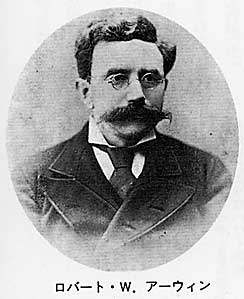
“Mr Dusky bought the large tract of land known as the Irwin homestead with frontages on Chaplain Lane, Fort street and Beretania street … he has erected the magnificent Progress building which is an ornament to the city and a credit to the owner to the architect and the builder.”
“In a few weeks the building will be delivered by the contractor to the owner and the public will have a chance to inspect and admire the structure which certainly is entitled to the name ‘Progress.’” (The Independent, April 25, 1898)
The building was completed in May 1898; by July, newspaper reports note that “every store and room in the building was rented.”
It is still here; however, what we see today is not a single building.
“Bruce Cartwright will now identify himself with the development of upper Fort street, yesterday he closed a deal with CS Desky for the purchase of the property just makai of the Progress block, and within ten days he will, it is slated, break ground for a three story stone and brick building, similar in construction and appearance to the Progress block. In fact the plans already prepared by Mr. Desky for an extension of his building will be used, with a few changes.” (Hawaiian Star, April 26, 1898)
“The makai wall of the present Progress Block will serve as the mauka wall of the new building. Arches will be made in this point wall and for the upper floors of the two blocks there will be used the same electric elevator.” (Hawaiian Gazette, May 6, 1898) Construction of Cartwright’s building started on May 4, 1898.
Some of the former users of the property returned; there are several references to Honolulu High School holding commencement exercises in Progress Hall. Others used the facilities, as well – including some ‘firsts’ in Hawaiʻi.
Progress Hall (“about the only available place at that time where meetings could be held”) ushered in the Elks (with 90 charter members, first initiation and installation took place April 15, 1901.) Likewise, the First Hebrew Congregation of Honolulu was formally organized at a meeting of some thirty of the Jewish residents of the city in Progress Hall Sunday afternoon, October 27, 1901.
In 1981, both buildings were completely gutted and a new interior designed of steel beams and heavy timber. Elevators, a new roof, central air conditioning, sprinkler systems, safety systems, new window designs and an entrance canopy were added. Some references say a fourth floor was added. (Burlingame)
Today, Hawaiʻi Pacific University occupies the Model Progress Building (it is not clear when the “Model” moniker was added to the building name;) uses include, Center for Student Life and First-Year Programs, Commuter Services, Dean of Students Office, ELS Language Center, faculty offices and spaces/uses for various departments and programs.