Within a few years after John Palmer Parker arrived in the Islands from Massachusetts in 1809 (he was then age 19), he had established a relationship with King Kamehameha I and received exclusive permission to hunt the wild cattle roving the countryside. (Paniolo Preservation Society)
Back then, carcasses were carried down the mountain slopes on the backs of Hawaiians. At a nearby port, the skins were turned over to King Kamehameha’s advisor. Hides were used in trading and the meat supplied the King’s ships. Later the whalers took on meat, tallow and hides. (Purdue Agriculturalist)
John Palmer Parker married Kipikane, the granddaughter of King Kamehameha. They had two sons, John II and Ebenezer, and a daughter, Mary Ann Kaulalani Parker. (Tracy)
John’s first property was in a remote area on the slopes of Mauna Kea, where he built a home that reminded him of the New England neighborhood where he grew up. Mana Hale (House of the Spirit) became a two-story Cape Cod “salt box” house, with a steep slate roof and plain white walls, small windows and a dormer.
It was almost completely made of koa wood: the narrow “ship style” staircase, three bedrooms, sitting rooms and great room, floors to ceilings, including much of the furniture. (Paniolo Preservation Society)
Kipikane had a dowery of 640 acres, and John bought 1,000 more acres the following year for 75 cents per acre; he continued to buy more land. (Tracy)
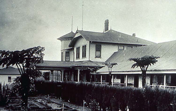
When John died in 1868, he willed half of the Parker property each to son John II and grandson Samuel Parker (son of Ebenezer – Ebenezer died in 1855). In 1879, John II purchased the “Hawaiian Victorian” mansion, Puuopelu. Originally built in 1862 by Englishman Charles Notley, Puuopelu became the heart of Parker Ranch. (Paniolo Preservation Society)
John II adopted Samuel’s son John III to be heir of his half of the Ranch; John III married Elizabeth Jane Lanakila Dowsett but died shortly after his daughter, Annie Thelma Kahilu‘onāpua‘api‘ilani Parker, was born and his half of the estate was put in trust for their daughter, Thelma. (Tracy)
“[F]ollowing the death of JP Parker II in 1891, there was growing tension between Samuel Parker, estate trustees, and JP Parker III. The latter Parker died in 1894”. (Maly)
“On October 14, 1895, AW wed Elizabeth Hartwell, daughter of Judge and Mrs AS Hartwell, at the home of the bride’s parents in Honolulu. This marriage produced four children: Alfred ‘Hartwell,’ Edith ‘Edie’ Millicent (later Mrs H Ernest Podmore), Dorothy, who died at age sixteen, and Barbara Juliette.” (Bergin)
“While he maintained a law office in Honolulu, it became increasingly evident that AW yearned to be a rancher. On December 20, 1897, he wrote to Louis Von Tempsky, a prominent Maui landholder and rancher: ‘You may not be aware that I have contemplated becoming a ranchman myself.’”
“On January 28, 1898, AW realized his dream by leading a group of business partners in the purchase of Molokai Ranch. The group was incorporated as the American Sugar Company, with an interest in continuing ranching in part while building a sugar plantation.” (Bergin)
Elizabeth sought out and hired Honolulu attorney and former judge Alfred Wellington “AW” Carter to manage the Ranch on Thelma’s behalf. (Paniolo Preservation Society)
“On September 25, 1899, AW Carter was appointed guardian and trustee of Thelma Parker … In accepting the appointment as guardian and trustee, AW relinquished several opportunities that other men would have found difficult to abandon …”
“… a lucrative law career in the burgeoning city of Honolulu, president of Charles R. Bishop Trust, an executive career with Bishop Bank, deputy attorney general, judge of the First Circuit Court, and trusteeship of Bernice Pauahi Bishop’s estate.” (Bergin)
“When AW assumed the reins of the ranch, the combined total of fee simple land owned by Thelma K Parker and her natural grandfather Sam Parker amounted to only some 34,000 acres, with large parcels under lease.”
“AW was immediately concerned that if neighboring ranchers acquired those leases, it would be necessary to dispose of a large part of the cowherd. In the short span of a dozen or so years, the fee simple holdings of Parker Ranch grew to 314,000 acres. Strategic government leases also were acquired.” (Bergin)
By 1902, Sam Parker, his cousin Eben Low, and backers, set in motion plans to take over the ranch and remove AW Carter from the role as trustee. Their first action was to contest Carter’s trusteeship of Annie Thelma K Parker. (Maly)
In 1903, “Sam approached AW with an offer to be bought out of his one-half interest of the entire ranch. The next day, AW offered him $600,000, and Sam left to think it over.” (Bergin)
“There were several things in the air that caused AW to believe that Sam was mounting a hostile takeover of the entire ranch instead of accepting his $600,000 offer.” (Bergin)
“Things got so heated between Samuel Parker and AW Carter, that a take over was attempted, and on June 7th, 1904, Eben Low, JA Magoon, and J Lightfoot stormed Carter’s office, with Low apparently brandishing his pistols. Things were heated, but no shots were fired.” (Maly)
On July 27, 1904, John S (Jack) Low filed a petition asking for the removal of Alfred W Carter, as guardian of the estate of Annie T. K. Parker. (Carter v. Gear, 197 U.S. 348 (1905), US Supreme Court) “A consortium made up of Sam Parker, Eben Low, Alfred Magoon, and Fred Wunderberg, who had Sam’s power of attorney, was behind this scheme.” (Bergin)
“The case was decided on November 3, 1905 in favor of AW Carter as trustee; and the case regarding partition of assets was decided in September 1906, thus bringing an end to more than five years of disagreements and litigation.” (Maly)
In 1906, Sam Parker sold his interest to Thelma Parker’s trust, and she became to the sole heir to the Parker Ranch. Thelma Parker married Henry Gaillard Smart when she was eighteen and had one child, Richard Smart, who survived her (a daughter died young).
In 1913, Richard Palmer Smart was born to Thelma and Henry. In 1914, both Thelma and Henry Smart died before Richard was two years old. Richard Smart, [the] last remaining heir to the Parker Dynasty, took over Ranch operations from Hartwell Carter, son of AW Carter during the middle of the 20th century. (South Kohala CDP)
Richard Smart died in 1992. In his will, Smart bequeathed most of Parker Ranch’s assets to the Parker Ranch Trust Foundation. The Parker Ranch Trust Foundation’s mission is to …
“Provide perpetual support for designated beneficiaries engaged in healthcare, education, and charitable support through the sound management of Trust assets while remaining mindful of the needs of the Kamuela community and its unique quality of life.”
Smart designated five beneficiaries: North Hawai‘i Community Hospital, Lucy Henriques Medical Center, Parker School Trust Corporation, Hawai‘i Preparatory Academy, and the Richard Smart Fund of the Hawai‘i Community Foundation. (South Kohala CDP)