Images of Old Hawaiʻi

  • Home
  • About
  • Categories
    • Ali’i / Chiefs / Governance
    • American Protestant Mission
    • Buildings
    • Collections
    • Economy
    • Missionaries / Churches / Religious Buildings
    • General
    • Hawaiian Traditions
    • Other Summaries
    • Mayflower Summaries
    • Mayflower Full Summaries
    • Military
    • Place Names
    • Prominent People
    • Schools
    • Sailing, Shipping & Shipwrecks
    • Voyage of the Thaddeus
  • Collections
  • Contact
  • Follow

January 14, 2023 by Peter T Young Leave a Comment

Kohala Ditch

Central to Hawaiʻi’s use of water has been agriculture, sugar in particular.

Initially brought to the islands by early Polynesians, the first successful commercial sugar plantation started in 1835.  And, with it, Hawai`i’s environmental, social and economic fabric changed.  Hawaiʻi’s economy turned toward sugar in the decades between 1860 and 1880; these twenty years were pivotal in building the plantation system.

What encouraged the development of plantation centers?  For one, the American settlement of California opened lucrative avenues of trade in the Pacific.  In addition, the Civil War virtually shut down Louisiana sugar production during the 1860s, enabling Hawai’i to compete in a California market that paid elevated prices for sugar.

The Pacific whaling trade collapsed after 1860, pushing Honolulu merchants into the sugar trade.  About the same time, the closing of the Hawaiian mission left the previously supported missionaries in search of new means of income.

The 1876 Treaty of Reciprocity between the United States and the Kingdom of Hawaiʻi eliminated the major trade barrier to Hawai`i’s closest and major market.  Through the treaty, the US received a station at Pearl Harbor and Hawaiʻi’s sugar planters received duty-free entry into US markets for their sugar.

For nearly a century, agriculture was the Island’s leading economic activity. It provided Hawai`i’s major sources of employment, tax revenues, and new capital through exports of raw sugar and other farm products.

Sugarcane requires a lot of water to grow. Pioneer sugar planters solved water shortages by diverting stream water and building irrigation systems that included aqueducts (the first in 1856), artesian wells (the first in 1879), and tunnels and mountain wells (the first in 1898).  These irrigation systems enabled the planters to expand their sugar production.

These irrigation systems were modeled largely after the elaborate and extensive diversion and ditches developed by the ancient Hawaiians.  Unlike the traditional Hawaiian system, which never diverted more than 50% of stream flow, the sugar plantations diverted large quantities of water from perennial streams and moved water from one ahupuaʻa to another.

Boston missionary Reverend Elias Bond sailed with the Ninth Company of Protestant Missionaries, arriving in the Islands in 1841. He was then assigned to Kohala.

As a means to provide employment to the people in the region and support his church and schools, in 1862, Reverend Bond founded Kohala Sugar Company, known as “The Missionary Plantation;” it produced its first sugar crop in 1865.  Bond gave all his dividends and profits beyond his living expenses to the Board of Missions.

Bond included the following in a letter: “So this was the ‘Missionary Plantation’, and the prophecies were many and loud that it would not live five years”. But in the goodness of God we came through.”  (Schweitzer)

From the mid-1800s, the sugar industry developed and commercial centers sprung up around the processing mills, especially in Kapaʻau and Hawi.  The construction of the railroad and the Kohala Ditch acted to encourage the further development of these more centrally-located communities.

Seven sugar mills operated in Kohala: Kohala, Union, Niuliʻi, Hawi, Halawa, Hōʻea and Star.  With the exception of Star, which existed for only a brief period of time, each was the nucleus of a community of plantation managers, supervisors, and laborers.  (In 1937, all of the mills were consolidated into Kohala Sugar Company.)

To water the crop, John Hind first conceived of an irrigation system tapping into the abundant, wild and inaccessible rivers that ribbon the Kohala Mountains.  In 1904, JS Low acquired a license from the Territory of Hawaiʻi to “enter upon, confine, conserve, collect, impound and divert all the running natural surface waters on the Kohala-Hāmākua Watershed;” he assigned the license to the Kohala Ditch Company.

Notable engineers and other professionals became involved in the construction of irrigation ditches that were the forerunners of large irrigation projects in the Western US.  Among the engineers was Michael Maurice O’Shaugnessy; he was both an investor in the Kohala Ditch Company and the Chief Engineer for the aqueduct.  (ASCE)

The Kohala Ditch, built by the Kohala Sugar Company, diverted water from the Honokāne Nui Stream to Hikapoloa, west of Hawi.  600-Japanese laborers worked on its construction; in the process, 17 lost their lives.

The laborers were housed under corrugated iron roofs. The raised floors “nearly always two-feet above the ground and higher if practicable” provided “a place for drying the men’s clothes in wet weather.” Additionally, “a hospital and medical department was also provided for the men, who were assessed 50-cents a month apiece for this object.”  (ASCE)

The Honokāne section of Kohala Ditch was opened on June 11, 1906; waters of Honokāne began flowing to the Kohala, Niuliʻi, Halawa, Hawi and Union mills.  The Awini section was finished in 1907; it started from the Waikoloa stream and traveled over 8-miles, mostly in tunnel, to the Awini weir where the water dropped 900-feet in a manmade waterfall into the Honokāne section.

The ditch carried the water for 23-miles northwest, mostly as tunnel, toward Hawi.  The capacity was originally 70-mgd, later reduced to 50-mgd, when the original flumes were replaced with smaller ones.

The ditch drops about 80-feet in elevation from 1,045-feet at the bottom of the intake at the first large stream (Honokāne) to 956-feet at the terminus in the plantation fields.

Prosperity came to Kohala. At the peak of its production, the Sugar Company had 600-employees; 13,000-acres of land produced 45,000-tons of raw sugar a year.

As with other sugar operations, it didn’t last.  1975 saw the last harvest at Kohala Sugar Company.  The district’s economy struggled.  Almost one-third of the workforce now commutes to South Kohala to work in the hotels and resorts located there.  However, the Ditch remained open for other agricultural needs.

Vulnerability and the risks associated with reliance on the Kohala Ditch were made evident on October 15, 2006, when two earthquakes struck off Kiholo and caused extensive damage to the Kohala Ditch.  In that instant, rockslides and other damage to the ditch stopped the water from flowing through the Ditch.

Two years later, on November 25, 2008, after extensive community involvement and public/private funding ($2-million in federal money, $500,000 from the state, $500,000 from Hawai`i County, $342,000 from Kamehameha Schools and $100,000 from AT&T), water was released back into the Kohala Ditch after repairs to the damage caused by the 2006 quakes.

Agricultural and hydroelectric users continue to benefit from the Ditch; in addition, entrepreneurs saw an opportunity for recreational/visitor industry uses of the ditch with kayak and raft rides through the flumes and tunnels of the Kohala Ditch.

© 2023 Hoʻokuleana LLC

Filed Under: Economy, General, Missionaries / Churches / Religious Buildings Tagged With: Treaty of Reciprocity, Kohala, Hind, Kohala Ditch, Elias Bond, Hawaii, Hawaii Island, Sugar

January 13, 2023 by Peter T Young Leave a Comment

1960 Kapoho Eruption

The eruption in Kilauea Iki had ended on December 21, but the shallow reservoir beneath the summit of Kilauea volcano was gorged with magma. Rather than removing pressure, the eruption had, for all intents and purposes, created more.

The end of 1959 was an uneasy time for the staff at the Hawaiian Volcano Observatory.  During the last week of the year, a swarm of earthquakes started in Pāhoa (more than 1,000 earthquakes were recorded by the Pāhoa station on January 12.)

The 1960 Kapoho eruption and its predecessor, the 1959 summit eruption in Kilauea Iki Crater, together formed a summit-flank sequence. The Kapoho eruption caused havoc in lower Puna, an idyllic rural community until the lava fountains and flows covered farm land and villages.

The size and frequency of the earthquakes increased; at 8 am, January 13, the ground was severely cracked along the fault through Kapoho town.  Movement along the fault was literally pulling the town apart.

The ground was constantly shaking. The roughly 300-residents undertook voluntary evacuation, which was completed by early evening.  At 7:35 pm, January 13, 1960, a red glow above Kapoho confirmed the start of the eruption.

Within half an hour, fountaining was nearly continuous along a nearly ½ – mile long fissure.  After a couple hours, the activity focused with central fountains – for the next 11-hours powerful steam blasts roared from the vents.

The resulting fallout coated everything with a thin film of fine, wet, glassy ash. Salt crystals formed as the water evaporated; they testified to the brackish nature of the groundwater.

By noon on January 14, the steam blasts had ended and lava fountaining was confined to many sources along a 650-foot long section of the fissure.  An ʻaʻa flow, 18-feet thick and nearly 1,000-feet wide reached the ocean – a bench formed 300-feet beyond the old shoreline.

In an attempt to save Warm Springs, bulldozers pushed a rock dike; shortly after, lava overtopped it and filled the pool.

Kapoho, a bit uphill of the fissure, was near all this activity but had not been touched by lava. Pumice and lava were wreaking havoc on nearby homes and farms (papaya, coconut, orchid and coffee groves.)

ʻAʻa continued to enter the ocean; it was also spreading southward.  Bulldozers worked in forming a barrier to protect Kapoho, Kapoho School, an area of expensive homes and real estate at Kapoho Beach Lots.  By January 20, lava had reached the barrier and overtopped it on January 23; a second barrier was shoved aside on January 27.

A third barrier held the flow, but lava then moved underground, beneath the end of the barrier, emerging near Kapoho School. The buildings began to burn at 10 am and the school was lost shortly after noon.

The barrier itself remained intact, and it survived until February 5, when it was finally overtopped and almost totally buried by lava that eventually covered the Kapoho cemetery.  More coastal houses were lost.

Despite notable developments in the vent area, Kapoho village remained virtually intact except for a blanket of pumice and ash that covered everything.

For seven hours on the afternoon of January 27, the heaviest pumice fall of the entire eruption rained down on the area during strong kona winds.

However, it was the lava flow that would doom the town.

Late that night, the rapidly moving ʻaʻa flow moved through the streets, overwhelmed building after building. By midnight January 27, most of Kapoho had been destroyed; a couple days later (January 30) the town was gone.

The eruption ended slowly. Dribbles of lava continued to enter the sea north of Cape Kumukahi as late as February 13. High fountains continued until February 15, when lava was spraying upward from the main vent area to heights of 600-feet.  It gradually subsided and on the morning of February 19, the eruption stopped.

Volcanologists concluded that the Kapoho eruption was tied to events at Kilauea’s distant summit.  On January 17, four days after the Kapoho eruption had started, the summit began to subside (deflate, by analogy with a balloon) as magma was leaving the storage reservoir and heading down the east rift zone to the Kapoho area.

The eruption was the first during the modern era of volcano monitoring at Hawaiʻi Volcanoes Observatory. As a result, probably more fundamental ideas were reached from it than from any other single eruption in Hawaiʻi.

The main lesson, and really the only one that bears repeating over and over again, is clear. What happened then will happen again. That lesson should never be lost.  (All information here is from USGS.)

© 2022 Hoʻokuleana LLC

Filed Under: General, Place Names Tagged With: Puna, Kapoho, Cape Kumukahi, Pahoa, Kilauea Iki, Kilauea, Hawaii, Volcano, Warm Springs, Waiwelawela

January 9, 2023 by Peter T Young Leave a Comment

Henry Poor

Henry French Poor was the eldest son of Henry Francis Poor and Caroline Paakaiulaula Bush; he was born here June 8, [1857].

“Poor received his early education under Mr. Gulick, Sr., father of the late Charles T. Gulick of Honolulu. He afterwards attended Punahou College, at that time under the direction of Professor Church.”

“He left school, however, at the age of 13 and entered the banking house of Bishop & Co. as a clerk, where he remained about eight years.”

“At that time, owing to ill health, Mr. Poor first visited the United States, where he spent some three months. When he returned to Honolulu he entered the mercantile house of Castle & Cooke.”

“At this time he was selected by the Government to act as secretary to Hon. C P. Iaukea, the head of the Hawaiian Embassy to the coronation of Alexander III of Russia.”

“Continuing from there he made a tour of the world, visiting the greater part of Europe, India, Japan, Egypt, the United States and England and meeting many great personages there. His visit to India was immediately connected with the question of securing a labor supply for the plantations of Hawaii.” (PCA, Nov 29, 1899)

“Henry F Poor was one of the most brilliant Hawaiians whose cradle ever rocked in these beautiful Islands.  … He possessed the generous spirit of his race and the keen intelligence of his New England’s forebears.”

“As secretary to Colonel Iaukea on the Kalakaua embassy to the rulers of the world he covered himself with honors and his bright letters were published in the local papers.” (The Independent, Nov 29, 1899)

“While abroad Mr. Poor received several foreign decorations, among which were the Order of the Rising Sun of Japan, the Order of Simon Bolivar of South America, an Austrian and a Russian order and several others. He also held the Hawaiian Order of Crown of Hawaii and Order of Kapiolani.” (PCA, Nov 29, 1899)

“Later on he went to Samoa with Governor Bush and to his tact and gentlemanly action was due the fact that the Kaimiloa incident did not end in an international scandal.” (The Independent, Nov 29, 1899)

“In 1887 [Kaimiloa] was purchased by King Kalakaua, and after being fitted up as a man-of-war, was sent on a mission to Samoa. This mission was a failure …”

“King Kalakaua had just returned from a trip around the world. Sundry people, at all the places he stopped filled him with hot air, and he wanted to be emperor of the Pacific. On his return to Honolulu he promptly set about the work of trying to get control of all the islands which had not yet been seized by European rulers.”

“[Kalakaua’s] Prime Minister, Gibson, induced him to fit out the Kaimiloa as a war ship and send it on a diplomatic mission to Samoa, where Ambassador ‘Ned’ Bush was instructed to either annex the place or induce the King of Samoa to make a treaty acknowledging that Kalakaua was the supreme ruler of a Pacific Island confederacy.”

“On board the warship was ‘Admiral’ Jackson, Ambassador Bush, Henry Poor, secretary of the legation, a big crew, an enormous quantity of gin, a band, and plenty of the King’s dreamy ideas of a Pacific confederacy.”

“To this day the mystery of how the vessel ever reached Samoa has not been solved, and it is a wonder that she ever got there at all, for gin and other drink never flowed freer on a private craft than it did on the Kaimiloa. …”

“Then wild with the dissipation or the voyage, the crew mutinied, and capturing Secretary Poor, chained him to the deck.”    (PCA Aug 8, 1902)


“The officers and crew of the Kaimiloa began to go ashore almost nightly to carouse in the streets of Apia. One night gunner William Cox, on returning to the ship, got into a fight with other officers.”

“He rushed the powder magazine, threatening to blow up the ship. Lt. Frank J. Waiau and ship’s carpenter John Galway stopped him, but the brawling went on. Lt. Sam I. Maikai, nominally in command, went ashore with Waiau to report to the Hawaiian legation.”

“They wanted to resign but Bush would not hear of it. He ordered them back on board and sent along his secretary, H. F. Poor. Jackson also went along with them. He and Poor, revolvers in hand, found the mutineers trying to take over the armory.

“They drove the mutineers out on deck. Waiau over-powered Cox and put him in irons on the bridge.” (Adler)

“The German warship Olga was in the harbor at the time, and her captain, noticing the row on the Hawaiian vessel, sent a longboat over … and threatened to tow the whole outfit bark to Hawaii unless the trouble subsided. …”

“On arrival [back in Honolulu] here [Kaimiloa] was dismantled, and never again used for war purposes. No one knows how many sins were committed aboard the vessel while trading in the South Seas, but many people have heard something of the story of her remarkable cruise as a man-of-war to Samoa.”   (PCA Aug 8, 1902)

Poor hosted Robert Louis Stevenson on his visit to the Islands.  On January 24, 1889, Stevenson arrived in Honolulu and spent the first six months of that year in the Hawaiian Islands (he later settled and lived in Samoa.)

“For the first few days the Stevenson party stayed with Henry Poor and his mother Mrs Caroline Bush, at 40 Queen Emma Street, Honolulu (24-27 January).”

“Then on 27 January 1889 they moved to Poor’s bungalow, Manuia Lanai, at Waikiki, three miles east of Honolulu.  In early February Stevenson decided to send the Casco back to San Francisco and stay on to work in Hawaii.”

“As a result he rented the house next to Henry Poor’s. This too was a one-storey ‘rambling house or set of houses’ in a garden, centred on a lanai, ‘an open room or summer parlour, partly surrounded with venetian shutters, in part quite open, which is the living room’”.  (RLS Website)

Henry French Poor died in Honolulu on November 28, 1899 and is buried at O‘ahu Cemetery.

© 2023 Ho‘okuleana LLC

Filed Under: Ali'i / Chiefs / Governance, Prominent People, Sailing, Shipping & Shipwrecks Tagged With: Henry Poor, Manuia Lanai, Hawaii, Kaimiloa, Robert Louis Stevenson, Curtis Iaukea

January 8, 2023 by Peter T Young Leave a Comment

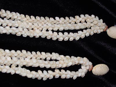
Ni‘ihau Lei Pūpū

Privately-owned by the Robinsons, with strict limited access, Ni‘ihau is the island that is least known and visited, and as such has the most intrigue (and thus referred to as the Forbidden Isle.)

In 1863, King Kamehameha IV put Ni‘ihau up for sale.  A purchase price of $10,000 was agreed to with buyers James and Francis Sinclair.  But Kamehameha IV died on November 30 before the closing, so Royal Patent No. 2944 shows his brother, Kamehameha V, completed the transaction in 1864.  Ownership was subsequently passed down through the family.

The 70-square-mile island (about half the size of Lāna‘i and twice as large as Kaho‘olawe) is the smallest inhabited island in Hawai‘i with 84 residents (mostly Native Hawaiian) and 35 houses (DBEDT & Census.)

The island lacks basic municipal infrastructure.  There are no paved roads (walking, horseback or bicycle are the only transportation options on Ni‘ihau.)  No water and wastewater systems.  No stores.  No restaurants.  No doctors.  No police.  No fire department.  (Ni‘ihau Cultural Heritage Foundation)

“‘Ni‘ihau shells’ means seashells harvested from the island of Ni‘ihau, its waters, or its beaches. [N]o person shall offer, display, expose for sale, or solicit for sale any product or jewelry item fabricated, processed, or manufactured with seashells …”

“… that is described, labeled, or identified using the term ‘Ni‘ihau’ or ‘Niihau’, either alone or in conjunction with other words, or in a trade or brand name …”

“… unless: (1) One hundred per cent of all shells in the product or jewelry item are Ni‘ihau shells; and (2) The product or jewelry item is fabricated, processed, or manufactured entirely within this State.”  (Hawai‘i Revised Statutes, §486-118.5)

Pu‘uwai village, on the western (leeward) side of the island, is the population center of Ni‘ihau.  On this side of the island are the main beaches where Ni‘ihau shells are collected that make the famous and collectible Ni‘ihau lei pūpū.

The origin of the Ni‘ihau shell lei is lost in antiquity, but it is clear that at the time of Captain James Cook first contact in 1778, shell lei were in existence.

A Ni‘ihau shell lei is in the British Museum and was most likely collected by Cook during one of his several visits to the island of Ni‘ihau.

Although ‘shell ornaments’ described by early visitors were primarily made of seashells, some were also made of land shells which were once common throughout the Islands. In the mid-1800s, hula dancers were described as wearing necklaces of shells as well as flower garlands and feather ornamentation.

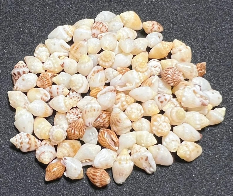
There are three different shells primarily used to make Ni‘ihau shell lei: kahelelani, momi and laiki. The color of the shells range from bright pink to pale yellow, and can have various types of markings on them.

Fabricating shell lei was not limited to Ni‘ihau, but it was there that this Hawaiian art flourished, most likely due to the abundance of shells available on the island’s beaches and the scarcity of flowers because of the arid climate.

In 1887, Queen Kapi‘olani had a formal portrait taken in New York on her way to attend Queen Victoria’s Jubilee. In the portrait, she wore a multi-strand lei of ivory-colored Ni‘ihau shells which complemented her formal Victorian dress.

Queen Emma, who showed more appreciation of Hawaiian crafts than any other of the Hawaiian royalty, also wore Ni‘ihau shell lei for formal portraits as well as when she was presented to Her Britannic Majesty.

It should be noted that during this time the shell lei was adapted to Victorian jewelry styles which included adding a clasp, thus elevating the traditional lei to the status of a piece of fine jewelry which was worn with the most elegant Western dress.

It is also interesting to note that later, particularly during the early- and mid-1900s, shell lei were more commonly reserved for occasions when Hawaiian attire was worn.

© 2023 Ho‘okuleana LLC

Filed Under: General, Ali'i / Chiefs / Governance, Hawaiian Traditions, Economy Tagged With: Kahelelani, Momi, Laiki, Shell, Hawaii, Niihau, Lei, Niihau Lei Pupu

January 7, 2023 by Peter T Young Leave a Comment

Pono Pineapple

Kapa‘a was the final home of the legendary chief Mō‘īkeha. Born at Waipi‘o on the island of Hawai‘i, Mō‘īkeha sailed to Kahiki (Tahiti), the home of his grandfather, Maweke, after a disastrous flood. On his return to Hawai‘i, he settled at Kapa‘a, Kauai.

Kila, Mō‘īkeha’s favorite of three sons by the Kauai chiefess Ho‘oipoikamalanai, was born at Kapa‘a and was considered the most handsome man on the island. It was Kila who was sent by his father back to Kahiki to slay his old enemies and retrieve a foster son, the high chief La‘amaikahiki.

Mō‘īkeha’s love for Kapa‘a is recalled in the ‘olelo no‘eau: Ka lulu o Mo‘ikeha i ka laulã o Kapa‘a “The calm of Mō‘īkeha in the breadth of Kapa‘a ” (Pukui 1983: 157) (McMahon)

The sugar industry came to the Kapa‘a region in 1877 with the establishment of the Makee Sugar Company and subsequent construction of a mill near the north end of the present town. Cane was cultivated mainly in the upland areas on former kula lands

The first crop was planted by the Hui Kawaihau, a group composed of associates of King Exploration Associates Ltd. David Kalākaua. The king threw much of his political and economic power behind the project to ensure its success.

The Hui Kawaihau was originally a choral society begun in Honolulu whose membership consisted of many prominent names, both Hawaiian and haole.

It was Kalākaua’s thought that the Hui members could join forces with Makee, who had previous sugar plantation experience on Maui, to establish a successful sugar corporation on the east side of Kauai. Captain Makee was given land in Kapa‘a to build a mill and he agreed to grind cane grown by Hui members.

Kalākaua declared the land between Wailua and Moloa‘a, the Kawaihau District, a fifth district and for four years the Hui attempted to grow sugar cane at Kapahi, on the plateau lands above Kapa‘a.

Kapa‘a town was founded by immigrant sugar workers who left their sugar mill towns and set up small private businesses. It is one of only two towns on Kauai that sprang up independent of sugar production.

Pineapple became the next largest commercial enterprise in the region. In the early 1900s, to help with the growing plantation population, government lands were auctioned off as town lots in Kapa‘a.

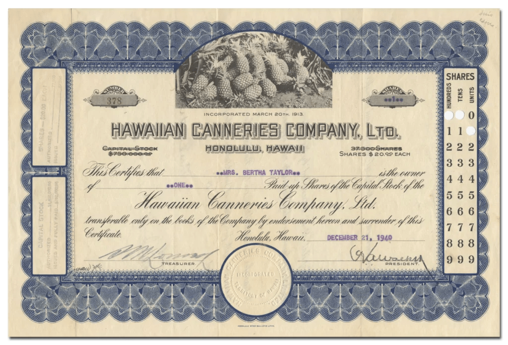
The first pineapple company on the island of Kauai was established in 1906.  In 1913, Hawaiian Canneries Company, Ltd opened in Kapa‘a. Through the Hawaiian Organic Act, Hawaiian Canneries purchased land they were leasing, approximately 8.75 acres, in 1923.

Hawaiian Canneries Co. cultivated pineapple scattered over 35 miles from Hanamaulu to Hanalei and processed and canned its pineapple at Kapa‘a canneries (now the site of Pono Kai Resort). (McMahon)

The Kapa‘a Cannery provided employment for many Kapa‘a residents. By 1960, 3400 acres were in pineapple and there were 250 full time employees and 1000 seasonal employees for the Kapa‘a Cannery.

On August 21, 1929, a US trademark registration was filed for ‘Pono’ by Hawaiian Canneries. The description provided to the trademark for Pono is ‘canned sliced and crushed pineapple and pineapple juice used for food-flavoring purposes’. (Trademarkia)  By 1956, the cannery was producing 1.5 million cases of pineapple.

Factory by-products – the crowns & skins from the processed pineapples – were loaded onto train carts and hauled up the coast to a pier.  The pineapple rubbish was then dumped into the ocean from the end of the pier. (Kauai Path)

As canned pineapple from other countries began filling the market, Hawaiian canneries began to close and plantations, once located on Maui, Oahu, Molokai, Lanai, and Kauai, began to shrink.

In 1962, Hawaiian Canneries went out of business due to foreign competition. (Exploration) Other smaller Kauai and Maui pineapple companies closed in the late-1960s.

In 1969, Hawaiian Fruit Packers (which was formed in 1937 by the reorganization of a company initially started by a group of ethnic Japanese growers) on Kauai, the last cannery remaining there, announced plans to cease planting. The cannery was closed in October 1973.  (Bartholomew etal)

Del Monte cannery closed in 1985, and Dole cannery in Iwilei closed in 1991. The Kahului cannery of Maui Land and Pineapple Company was the last remaining pineapple cannery in Hawai‘i.

The Hawaiian pineapple industry has gone from its early days as a primarily fresh product, through most of the 20th century as principally a canned product and a major supplier of the worlds canned pineapple market, to the 21st century when it is once again grown mostly for fresh consumption.  (HAER)

© 2023 Ho‘okuleana LLC

Filed Under: Economy, General Tagged With: Hawaiian Canneries, Pono Pineapple, Hawaii, Pineapple, Kapaa

  • « Previous Page
  • 1
  • …
  • 158
  • 159
  • 160
  • 161
  • 162
  • …
  • 562
  • Next Page »

Images of Old Hawaiʻi

People, places, and events in Hawaiʻi’s past come alive through text and media in “Images of Old Hawaiʻi.” These posts are informal historic summaries presented for personal, non-commercial, and educational purposes.

Info@Hookuleana.com

Connect with Us

  • Email
  • Facebook
  • LinkedIn
  • Twitter
  • YouTube

Recent Posts

  • Carriage to Horseless Carriage
  • Fire
  • Ka‘anapali Out Station
  • Lusitana Society
  • “Ownership”
  • ‘Holy Moses’
  • Mikimiki

Categories

  • Mayflower Summaries
  • American Revolution
  • General
  • Ali'i / Chiefs / Governance
  • Buildings
  • Missionaries / Churches / Religious Buildings
  • Hawaiian Traditions
  • Military
  • Place Names
  • Prominent People
  • Schools
  • Sailing, Shipping & Shipwrecks
  • Economy
  • Voyage of the Thaddeus

Tags

Albatross Al Capone Ane Keohokalole Archibald Campbell Bernice Pauahi Bishop Charles Reed Bishop Downtown Honolulu Eruption Founder's Day George Patton Great Wall of Kuakini Green Sea Turtle Hawaii Hawaii Island Hermes Hilo Holoikauaua Honolulu Isaac Davis James Robinson Kamae Kamaeokalani Kamanawa Kameeiamoku Kamehameha Schools Lalani Village Lava Flow Lelia Byrd Liliuokalani Mao Math Mauna Loa Midway Monk Seal Northwestern Hawaiian Islands Oahu Papahanaumokuakea Marine National Monument Pearl Pualani Mossman Queen Liliuokalani Thomas Jaggar Volcano Waikiki Wake Wisdom

Hoʻokuleana LLC

Hoʻokuleana LLC is a Planning and Consulting firm assisting property owners with Land Use Planning efforts, including Environmental Review, Entitlement Process, Permitting, Community Outreach, etc. We are uniquely positioned to assist you in a variety of needs.

Info@Hookuleana.com

Copyright © 2012-2024 Peter T Young, Hoʻokuleana LLC


Loading Comments...