Images of Old Hawaiʻi

  • Home
  • About
  • Categories
    • Ali’i / Chiefs / Governance
    • American Protestant Mission
    • Buildings
    • Collections
    • Economy
    • Missionaries / Churches / Religious Buildings
    • General
    • Hawaiian Traditions
    • Other Summaries
    • Mayflower Summaries
    • Mayflower Full Summaries
    • Military
    • Place Names
    • Prominent People
    • Schools
    • Sailing, Shipping & Shipwrecks
    • Voyage of the Thaddeus
  • Collections
  • Contact
  • Follow

March 7, 2023 by Peter T Young Leave a Comment

Kumukahi

Mai ka hikina a ka Ia i
Kumukahi a ka welona a ka Iā i Lehua.

From the sunrise at Kumukahi to
the fading sunlight at Lehua.

From sunrise to sunset. Kumukahi, in Puna, Hawai‘i, was called the land of the sunrise and Lehua, the land of the sunset. This saying also refers to a life span-from birth to death.  (Pukui, #258)

Kumukahi is a place of importance and a place of healing. Practitioners of la‘au lapa‘au often prayed to Kumukahi and his brother Palamoa as “deities of healing” when gathering and applying traditional Hawaiian herbal medicine. These practitioners would face the Hikina (East) and chant their prayers at sunrise from where ever they were living in the islands. (Lopes)

Kumukahi is translated as the ‘beginning/first source, chief, or teacher,’ in reference to the “first source” of wisdom, knowledge or of knowing.

This is because of its location in relation to the sun, Kānehoalani (an akua who is, in one story, Pele’s father) and what the sun represents, as the easternmost point of Hawaiʻi.

It is the beginning of our collective consciousness as people of Hawaiʻi, which establishes Kumukahi as a wahi pana (living and celebrated place) and a wahi moʻolelo (a storied place). (Hawai‘i County)

Kumukahi was also noted as a “leina a ka uhane,” a place where the soul of a person would leap from this world into the next after death. (Lopes)

Kumukahi was named for a migratory hero from Kahiki (Tahiti) who stopped here and who is represented by a red stone. Two of his wives, also in the form of stones, manipulated the seasons by pushing the sun back and forth between them. One of the wives was named Ha‘eha‘e. Sun worshipers brought their sick to be healed here. (Pukui)

In some accounts, Kumukahi is a kolea bird and is referred to as “the messenger of the gods.” According to Pukui, Kumukahi was the name of a “kanaka aiwaiwa,” a divine being who loved sports, especially holua sledding.

For this reason Pele, the akua wahine of the volcano, was fond of him. Kumukahi often produced sporting events in which his people participated. Pele often joined in on these particular festivities in the form of an attractive woman.

However, on one such occasion, Pele, disguised as an old woman, requested to participate and was denied. In her anger, she chased Kumukahi to the sea where she covered him with her lava. (Lopes)

At the tip of Cape Kumukahi were a number of stone cairns, built of the rough lava from the surrounding flow, which are said to have been built by the various monarchs of the Hawaiian kingdom upon assuming the throne. Some reference them as Ki‘i Pōhaku Ali‘i – King’s Pillars.

In 1823, William Ellis and members of the ABCFM toured the island of Hawai‘i seeking out community centers in which to establish church centers for the growing Protestant mission.

Settlement patterns in Puna tend to be dispersed and without major population centers. Villages in Puna tended to be spread out over larger areas and often are inland, and away from the coast, where the soil is better for agriculture.  (Escott)

This was confirmed on William Ellis’ travel around the island in the early 1800s, “Hitherto we had travelled close to the sea-shore, in order to visit the most populous villages in the districts through which we had passed.”

“But here receiving information that we should find more inhabitants a few miles inland, than nearer the sea, we thought it best to direct our course towards the mountains.”  (Ellis, 1823)

Ellis noted, “The population of this part of Puna, though somewhat numerous, did not appear to possess the means of subsistence in any great variety or abundance; and we have often been surprised to find the desolate coasts more thickly inhabited than some of the fertile tracts in the interior …”

“… a circumstance we can only account for, by supposing that the facilities which the former afford for fishing, induce the natives to prefer them as places of abode; for they find that where the coast is low, the adjacent water is generally shallow.”

When the Lighthouse Board assumed control of Hawai‘i’s lighthouses in 1904, it began work on a plan to erect major lights to better mark approaches to the islands. Funds for Makapu‘u Lighthouse were secured in 1906, money for Molokai lighthouse was obtained in 1907, and Congress made an appropriation for Kilauea Point Lighthouse in 1908.

These aids to navigation were seen as “material benefit to the business .community, to shipping interests, insurance interests and mercantile interests. … [T]he next one we have recommended is for a first order light at Cape Kumukahi, the easternmost point on the Island of Hawaii.”  (PCA, Nov 4, 1908)

“There is at present no landfall light for vessels bound to Hawaii by way of Cape Horn. Several vessels have within recent years gone ashore on Kumukahi Point. This is the first land sighted by vessels from the southward and eastward.”

“The shipping from these directions now merits consideration, and with the improvement of business at Hilo the necessity for a landfall light on this cape grows more urgent. It is estimated that a light at this point can be established for not exceeding $75,000, and the Board recommends that an appropriation of this amount be made therefor.” (Report of the Lighthouse Board, 1908)

On December 31, 1928, the US government purchased fifty-eight acres on Cape Kumukahi from the Hawaiian Trust Company for the sum of $500. During the following year, a thirty-two-foot wooden tower capped with an automatic acetylene gas light was built at the cape for local use.  It was replaced in 1933 by a 125-foot pyramidical galvanized steel tower. (Lighthouse Friends)

“Life was peaceful for several years along the Puna coastline until a lava flow threatened Kapoho in 1955. [Kumukahi lightkeeper Joe] Pestrella stayed at his post to watch over the lighthouse as the lava advanced.” 

“The following year, he received the “Civil Servant of the Year” award from the U.S. Coast Guard for his bravery in staying at his post. At the time, Ludwig Wedemeyer, leader of the Hilo Coast Guard station, noted it was the first time a Hawai‘i Island resident had received such an award from the Coast Guard.” (Laitinen)

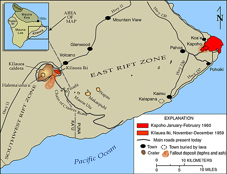
On January 12, 1960, over 1,000 earthquakes were recorded near Kapoho Village, just above Kumukahi. The earthquakes grew in size and frequency, creating large fractures along the Kapoho Fault overnight.  The 1960 Kīlauea eruption began on the night of January 13.

For the first two weeks, Kapoho village remained virtually intact except for a blanket of pumice and ash that covered everything. The lava flow issuing from the growing cinder cone was moving in the opposite direction of town.

Things changed on January 27th when very fluid lava poured from the vents and fed massive ‘a‘ā flows that moved southwestward through the streets of town. By midnight, most of Kapoho had been destroyed.

By January 28, lava destroyed Coast Guard residences near Cape Kumukahi, but the lighthouse was spared. The Koa‘e Village fell victim to lava flow progression, losing the community hall, a local church and one residence.  The eruption stopped February 19. (USGS)

“After the 1960 eruption ended, an electric line was run from Kapoho Beach Lots to the lighthouse to restore power, and the light became automated. Joe was transferred to a lighthouse on O‘ahu, and when he retired in 1963, he was the last civilian lighthouse keeper in Hawai‘i.”  (Laitinen)

With prevailing NW trade winds and nothing between it and the America continents, except thousands of miles of open ocean, Kumukahi has some of the cleanest air in the Northern Hemisphere.

The Kumukahi light tower is also used as a monitoring station to test air quality. Since 1993, scientists have been taking ambient air samples every week for chemical analysis.

The long-term data records supplied by these samples are fundamental to understanding changes in atmospheric composition of gases affecting stratospheric ozone, climate and air quality, and provide an avenue to detect unexpected changes in these chemicals.

The 2018 eruptions interrupted the sampling efforts and NOAA scientists have undertaken novel development of an uncrewed aircraft system (UAS) “hexacopter” that will enable the lab to not only recommence a long-standing mission that was recently forced to halt, but paves the way toward enhanced operations in the future.  (NOAA)

© 2023 Ho‘okuleana LLC

Filed Under: Economy, Hawaiian Traditions, Place Names Tagged With: Hawaii, Hawaii Island, Cape Kumukahi, Kumukahi

February 28, 2023 by Peter T Young Leave a Comment

It was a dark and stormy night …

“It was said that on a certain night of heavy down pouring rain – the lightning struck its wrathful flashes into the sky – the thunder pounded with all its might – the stormy wind veered every which way – the red water churned in the streams.”  (Poepoe, Ahlo)

The child born that night was of royal blood, and was destined to become not only the king of Hawaiʻi, but the conqueror and sovereign of the group.

They say the child was poʻolua, “that is, a child of two fathers, (it) was considered a great honor by chiefs of that period.” (Luomala)  Some say that his mother, Kekuʻiapoiwa (married to Keōua,) had a liaison with Kahekili (ruler of Maui.)

Though Kahekili was thought to possibly be his biological father, he was raised by his parents (and was considered the son of Kekuʻiapoiwa and Keōua.)

The exact year of his birth is not known; different historians/writers place the year of his birth from about 1736 to 1759.

He was said to be born at Kokoiki (”little blood,” referring to the first signs of childbirth – Kokoiki is one of the star names listed in the Kumulipo chant.)
Another notes, “(A) bright and beautiful star, appeared at Kokoiki on the night before the child was born and is hence called Kokoiki.”  (Kūʻokoʻa Home Rula, Ahlo)  (Scientific study places Halley’s Comet in the same relative position in the Hawaiian sky on December 1, 1758.  (Ahlo))

Keʻāulumoku predicted that he “would triumph over his enemies, and in the end be hailed as the greatest of Hawaiian conquerors.”  (Kalākaua)

Word went out to find and kill the baby, but the Kohala community conspired to save him.

“A numerous guard had been set to wait the time of birth. The chiefs kept awake with the guards (for a time,) but due to the rain and the cold, the chiefs fell asleep, and near daybreak Kekuʻiapoiwa went into the house and, turning her face to the side of the house at the gable end, braced her feet against the wall.”

“A certain stranger (Naeʻole) was outside the house listening, and when he heard the sound of the last bearing-down pain (kuakoko), he lifted the thatch at the side of the house, and made a hole above.”

“As soon as the child was born, had slipped down upon the tapa spread out to receive it, and Kekuʻiapoiwa had stood up and let the afterbirth (ewe) come away, he covered the child in the tapa and carried it away.”  (Kamakau)

The young child, Kamehameha, was carried on a perilous journey through Kohala and Pololū Valley to Awini.  (KamehamehaDayCelebration)

Hawi, meaning ”unable to breathe,” was where the child, being spirited away by a servant, required resuscitation and nursing. Kapaʻau, meaning ”wet blanket,” was where heavy rain soaked the infant’s kapa (blanket.)  Halaʻula (scattered blood) was the town where soldiers were killed in anger.  (Sproat – (Fujii, NY Times))  Some believe Kamehameha also spent much of his teen years in Pololū (long spear.)

“Kamehameha (Kalani Pai‘ea Wohi o Kaleikini Keali‘ikui Kamehameha o ‘Iolani i Kaiwikapu Kaui Ka Liholiho Kūnuiākea) was a man of tremendous physical and intellectual strength. In any land and in any age he would have been a leader.”  (Kalākaua, ROOK)

While still in his youth, Kamehameha proved his right to rule over all the islands by lifting the Naha Stone at Pinao Heiau in Pi‘ihonua, Hilo (c. 1773.) (ROOK)

By the time of Cook’s arrival (1778,) Kamehameha had become a superb warrior who already carried the scars of a number of political and physical encounters. The young warrior Kamehameha was described as a tall, strong and physically fearless man who “moved in an aura of violence.” (NPS)

The impress of his mind remains with his crude and vigorous laws, and wherever he stepped is seen an imperishable track. He was so strong of limb that ordinary men were but children in his grasp, and in council the wisest yielded to his judgment. He seems to have been born a man and to have had no boyhood.  (Kalākaua)

He was always sedate and thoughtful, and from his earliest years cared for no sport or pastime that was not manly. He had a harsh and rugged face, less given to smiles than frowns, but strongly marked with lines indicative of self-reliance and changeless purpose.  (Kalākaua)

He was barbarous, unforgiving and merciless to his enemies, but just, sagacious and considerate in dealing with his subjects. He was more feared and admired than loved and respected; but his strength of arm and force of character well fitted him for the supreme chieftaincy of the group, and he accomplished what no one else could have done in his day.  (Kalākaua)

In 1790 (at the same time that George Washington was serving as the US’s first president,) the island of Hawaiʻi was under multiple rule; Kamehameha (ruler of Kohala, Kona and Hāmākua regions) successfully invaded Maui, Lanai and Molokai.

He sent an emissary to the famous kahuna (priest, soothsayer,) Kapoukahi, to determine how he could conquer all of the island of Hawaiʻi.  According to Thrum, Kapoukahi instructed Kamehameha “to build a large heiau for his god at Puʻukoholā, adjoining the old heiau of Mailekini.”

It is estimated that the human chain from Pololū Valley to Puʻukohola had somewhere between 10,000-20,000 men carrying stones from Pololū Valley to Kawaihae. (NPS)

After completing the heiau in 1791, Kamehameha invited Keōua to come to Kawaihae to make peace.  However, as Keōua was about to step ashore, he was attacked and killed by one of Kamehameha’s chiefs.

With Keōua dead, and his supporters captured or slain, Kamehameha became King of Hawaiʻi island, an event that according to prophesy eventually led to the conquest and consolidation of the islands under the rule of Kamehameha I.

It was the koa (warriors) of Hilo who supported Kamehameha in his early quest to unite Moku O Keawe. After gaining control of Moku O Keawe, Kamehameha celebrated the Makahiki in Hilo in 1794.  (ROOK)

The village and area of Hilo was named by Kamehameha after a special braid that was used to secure his canoe. Kamehameha and Keōpūolani’s son, Liholiho (Kamehameha II) was born in Hilo (1797.)  (ROOK)

Kamehameha’s great war fleet, Peleleu, that was instrumental in Kamehameha’s conquest, was built and based at Hilo (1796-1801). After uniting all of the islands under his rule in 1810, Hilo became Kamehameha’s first seat of government.  (ROOK)

It was in Hilo that Kamehameha established his greatest law, the Kānāwai Māmalahoe (Law of the Splintered Paddle).  (ROOK)  Kamehameha’s Law of the Splintered Paddle of 1797 is enshrined in the State constitution, Article 9, Section 10:  “Let every elderly person, woman and child lie by the roadside in safety”.

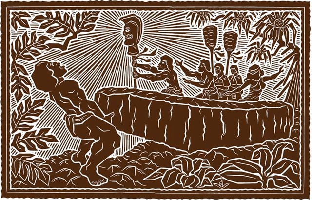
It has become a model for modern human rights law regarding the treatment of civilians and other non-combatants.  Kānāwai Māmalahoe appears as a symbol of crossed paddles in the center of the badge of the Honolulu Police Department.  The image shows Kamehameha as a young warrior (HerbKane.)

© 2023 Hoʻokuleana LLC


Filed Under: Ali'i / Chiefs / Governance Tagged With: North Kohala, Puukohola, Naha Stone, Hawaii, Kokoiki, Hawaii Island, Kekuiapoiwa, Hilo, Law of the Splintered Paddle, Kamehameha, Kanawai Mamalahoe, Kahekili, Liholiho, Keoua, Kohala

February 17, 2023 by Peter T Young Leave a Comment

Mauna Loa Boys School

“In 1945 Governor Ingram Stainback requested that Director of Institutions, Thomas B. Vance, concentrate his efforts on developing self-supporting prison industries.”

“With that in mind, Kulani Prison Camp, opened in 1945 as the successor to Waiakea Prison Camp, operated a lumbering enterprise producing logs and milled lumber of native hardwoods as materials to be processed and sold from Oahu Prison’s industrial area.” (Department of Institutions Summary 1939-1958)

The development of Kulani Camp and its means of access, the Stainback Highway, fell under the management of Vance. (Maly)

“Kulani … provided a reservoir of manpower for the construction of public roads on Hawaii …. – roads that would have been economically prohibitive if built under contract.” (Department of Institutions Summary 1939-1958)

Today, Kulani Correctional Facility (KCF) is a 200-bed minimum security prison located on the slope of Mauna Loa, approximately 20 miles south east of Hilo, Big Island of Hawai’i.

In addition to the Kulani Prison Camp, in 1946, they planned the Mauna Loa Boys School. “There is nothing experimental about the boys’ school project. It is to be built four miles from the proposed new prison site”. (Honolulu Advertiser, October 2, 1946)

The plan was to “move delinquent boys from Waialee [on the North Shore of O‘ahu] to Mauna Loa, on Hawai‘i.” (Star-Bulletin, Jan 4, 1947)

In addition, “The purpose of the Mauna Loa camp is to segregate the older juveniles from Koolau where they are an influence on younger delinquents.” (Hawaii Tribune Herald, July 31, 1953)

“Work got under way thus week on Mauna Loa boy’s forestry camp on the Big Island. Because all bids were higher than the territorial department of institutions could afford, prisoners from Kulani project and the boys who will occupy the camp are to finish the work.”

“The camp is five miles north of Kulani Project.” “It is built on the same plan as the new Koolau Boys’ home on Oahu. Forty boys whose ages range from 16 to 19 will be quartered there.” (Star-Bulletin, Oct 5, 1950)

“The Mauna Loa Forestry Camp will open officially tomorrow … ‘I believe that the Mauna Loa Forestry Camp program will quickly evolve into one of the most forward looking steps that the territory has taken in mapping a solution to the problem of youth offenders.’”

“The fourteen young men from Koolau are almost all in the 18 and 19 year old age group. They are a highly selected group of young men who have not only volunteered for the forestry camp assignment but who have insisted on it”.

“‘The plan for the young men to take over the forestry camp at this time,’ Mr. Vance [Director of Public Institutions] said, ‘came about as a result of the Lions trip to the summit of Mauna Loa.’”

“‘Four of the young men from Koolau spent Thursday and Friday nights, at the forestry camp March 20 and 21 and joined the Lions on the Mauna Loa summit trip March 22. They asked their superintendent, Mr. Henry, for a conference with me before the Lions left the mountain summit.’”

“‘The conference was held at the United States weather bureau laboratory atop Mauna Loa. The four young men from Koolau asked for the privilege of completing their own structure at the forestry camp, rather than having Kulani do it for them. They reason that it is their plant.’”

“‘They are not boys; they are young men who are just as capable or heavy construction work as the men at Kulani. Many of the forestry camp’s young men will soon be due for parole or discharge. Before that time, they want to make a constructive contribution to the building of the camp.’”

“‘I was somewhat surprised to find that occupancy of the forestry camp and the initiation of a CCC type of operation represents the realization of a dream to the young men in our training school system just as much as it does to me.’”

“‘When the four Koolau boys’ home visitors to the forestry camp returned to Koolau, they presented their plan to William G Among, superintendent, division of training schools. He and I then conferred and the plan was approved.’”

“‘The fourteen young men at the forestry camp will be housed in the duplex staff apartment of the main structure until they complete their own quarters.’” (Superintendent William Henry, Hawaii Tribune Herald, April 3, 1952)

By 1953 the facility was operational, but legislative appropriations did not make ends meet, “‘We find it impossible to operate Mauna Loa within our budget.’ [William Among, superintendent of the division of training schools] said. “There is an $11 per capita per day expense at Mauna Loa and the legislature has only given $2.60 to meet this.” (Star Bulletin, Sept 8, 1959)

When Territorial House members toured the camp in 1953 they called the project “one of the most expensive and impractical projects ever constructed in the Territory of Hawai‘i”. (DLNR)

“Before it went into full operation there was a change of administrations”. “One man’s dream of a better life for delinquent boys has become an efficiency expert’s nightmare.” “Defenders of the original plan say it was not given a chance.” The camp was closed on October 1, 1953.

However, it was not always rosy when it was operating. “The propensity for escape by these inmates debuted July 19, 1952, when 14 boys walked away from a picnic on Coconut Island and scattered all over Hilo. … It took 25 policemen more than 14 hours to round up the escapee”. There were other escapes.

Likewise, “Inmates at reform schools have a penchant for stealing cars, and those at Mauna Loa Forestry Camp were no exception. On Sept. 17, 1952, three youths stole a panel truck and went for a joy ride up the Stainback Highway …”

On their return, the driver “lost control of the speeding truck. It went off the road and overturned several times.” One of the occupants “was pinned under the wreckage and killed. … [the driver] was later charged with negligent homicide and sentenced to five years in Oahu Prison.” (Warshauer)

“Nobody knows what to do with the Mauna Loa Forestry Camp, rising like a fortress of concrete and steel in a rain-drenched mountain fortress 28 miles from Hilo.” (Star Bulletin, Sept 8, 1959) It was temporarily turned into a warehouse.

Since closure the facility was used intermittently by Kūlani Correctional Facility and by the military for training. (DLNR) “On June 15, 1969, the Division of Forestry and Fish and Game of the state Department of Land and Natural Resources issued a permit to the 29th Infantry for field training. The assaulted the abandoned building June 19-23, 1969, leaving it the wreck it remains today.” (Warshauer)

© 2023 Ho‘okuleana LLC

Filed Under: General, Schools, Economy Tagged With: Hawaii, Hawaii Island, Mauna Loa Boys School, Mauna Loa Forestry Camp

January 14, 2023 by Peter T Young Leave a Comment

Kohala Ditch

Central to Hawaiʻi’s use of water has been agriculture, sugar in particular.

Initially brought to the islands by early Polynesians, the first successful commercial sugar plantation started in 1835.  And, with it, Hawai`i’s environmental, social and economic fabric changed.  Hawaiʻi’s economy turned toward sugar in the decades between 1860 and 1880; these twenty years were pivotal in building the plantation system.

What encouraged the development of plantation centers?  For one, the American settlement of California opened lucrative avenues of trade in the Pacific.  In addition, the Civil War virtually shut down Louisiana sugar production during the 1860s, enabling Hawai’i to compete in a California market that paid elevated prices for sugar.

The Pacific whaling trade collapsed after 1860, pushing Honolulu merchants into the sugar trade.  About the same time, the closing of the Hawaiian mission left the previously supported missionaries in search of new means of income.

The 1876 Treaty of Reciprocity between the United States and the Kingdom of Hawaiʻi eliminated the major trade barrier to Hawai`i’s closest and major market.  Through the treaty, the US received a station at Pearl Harbor and Hawaiʻi’s sugar planters received duty-free entry into US markets for their sugar.

For nearly a century, agriculture was the Island’s leading economic activity. It provided Hawai`i’s major sources of employment, tax revenues, and new capital through exports of raw sugar and other farm products.

Sugarcane requires a lot of water to grow. Pioneer sugar planters solved water shortages by diverting stream water and building irrigation systems that included aqueducts (the first in 1856), artesian wells (the first in 1879), and tunnels and mountain wells (the first in 1898).  These irrigation systems enabled the planters to expand their sugar production.

These irrigation systems were modeled largely after the elaborate and extensive diversion and ditches developed by the ancient Hawaiians.  Unlike the traditional Hawaiian system, which never diverted more than 50% of stream flow, the sugar plantations diverted large quantities of water from perennial streams and moved water from one ahupuaʻa to another.

Boston missionary Reverend Elias Bond sailed with the Ninth Company of Protestant Missionaries, arriving in the Islands in 1841. He was then assigned to Kohala.

As a means to provide employment to the people in the region and support his church and schools, in 1862, Reverend Bond founded Kohala Sugar Company, known as “The Missionary Plantation;” it produced its first sugar crop in 1865.  Bond gave all his dividends and profits beyond his living expenses to the Board of Missions.

Bond included the following in a letter: “So this was the ‘Missionary Plantation’, and the prophecies were many and loud that it would not live five years”. But in the goodness of God we came through.”  (Schweitzer)

From the mid-1800s, the sugar industry developed and commercial centers sprung up around the processing mills, especially in Kapaʻau and Hawi.  The construction of the railroad and the Kohala Ditch acted to encourage the further development of these more centrally-located communities.

Seven sugar mills operated in Kohala: Kohala, Union, Niuliʻi, Hawi, Halawa, Hōʻea and Star.  With the exception of Star, which existed for only a brief period of time, each was the nucleus of a community of plantation managers, supervisors, and laborers.  (In 1937, all of the mills were consolidated into Kohala Sugar Company.)

To water the crop, John Hind first conceived of an irrigation system tapping into the abundant, wild and inaccessible rivers that ribbon the Kohala Mountains.  In 1904, JS Low acquired a license from the Territory of Hawaiʻi to “enter upon, confine, conserve, collect, impound and divert all the running natural surface waters on the Kohala-Hāmākua Watershed;” he assigned the license to the Kohala Ditch Company.

Notable engineers and other professionals became involved in the construction of irrigation ditches that were the forerunners of large irrigation projects in the Western US.  Among the engineers was Michael Maurice O’Shaugnessy; he was both an investor in the Kohala Ditch Company and the Chief Engineer for the aqueduct.  (ASCE)

The Kohala Ditch, built by the Kohala Sugar Company, diverted water from the Honokāne Nui Stream to Hikapoloa, west of Hawi.  600-Japanese laborers worked on its construction; in the process, 17 lost their lives.

The laborers were housed under corrugated iron roofs. The raised floors “nearly always two-feet above the ground and higher if practicable” provided “a place for drying the men’s clothes in wet weather.” Additionally, “a hospital and medical department was also provided for the men, who were assessed 50-cents a month apiece for this object.”  (ASCE)

The Honokāne section of Kohala Ditch was opened on June 11, 1906; waters of Honokāne began flowing to the Kohala, Niuliʻi, Halawa, Hawi and Union mills.  The Awini section was finished in 1907; it started from the Waikoloa stream and traveled over 8-miles, mostly in tunnel, to the Awini weir where the water dropped 900-feet in a manmade waterfall into the Honokāne section.

The ditch carried the water for 23-miles northwest, mostly as tunnel, toward Hawi.  The capacity was originally 70-mgd, later reduced to 50-mgd, when the original flumes were replaced with smaller ones.

The ditch drops about 80-feet in elevation from 1,045-feet at the bottom of the intake at the first large stream (Honokāne) to 956-feet at the terminus in the plantation fields.

Prosperity came to Kohala. At the peak of its production, the Sugar Company had 600-employees; 13,000-acres of land produced 45,000-tons of raw sugar a year.

As with other sugar operations, it didn’t last.  1975 saw the last harvest at Kohala Sugar Company.  The district’s economy struggled.  Almost one-third of the workforce now commutes to South Kohala to work in the hotels and resorts located there.  However, the Ditch remained open for other agricultural needs.

Vulnerability and the risks associated with reliance on the Kohala Ditch were made evident on October 15, 2006, when two earthquakes struck off Kiholo and caused extensive damage to the Kohala Ditch.  In that instant, rockslides and other damage to the ditch stopped the water from flowing through the Ditch.

Two years later, on November 25, 2008, after extensive community involvement and public/private funding ($2-million in federal money, $500,000 from the state, $500,000 from Hawai`i County, $342,000 from Kamehameha Schools and $100,000 from AT&T), water was released back into the Kohala Ditch after repairs to the damage caused by the 2006 quakes.

Agricultural and hydroelectric users continue to benefit from the Ditch; in addition, entrepreneurs saw an opportunity for recreational/visitor industry uses of the ditch with kayak and raft rides through the flumes and tunnels of the Kohala Ditch.

© 2023 Hoʻokuleana LLC

Filed Under: Economy, General, Missionaries / Churches / Religious Buildings Tagged With: Sugar, Treaty of Reciprocity, Kohala, Hind, Kohala Ditch, Elias Bond, Hawaii, Hawaii Island

December 9, 2022 by Peter T Young Leave a Comment

Scorching Post Cards

According to Thrum, the first white man to stay overnight in Kilauea Caldera was CS Bartow, the postmaster of Lahaina on Maui, visiting Hawaii. Bartow suggested the nighttime excursion to his fellow travelers, and while they decided against the idea, the postmaster could not be dissuaded.

In 1898, Lorrin Thurston owner of Volcano House and head of the Hawai‘i Promotion Committee (forerunner to the Hawai‘i Visitors and Convention Bureau) worked closely with the Inter-Island Steam Navigation Company to create an excursion business from Honolulu to his hotel at Kīlauea.

Although he sold his interest in Volcano House to hotelier George Lycurgus (1858–1960) in 1904, Thurston continued to promote Kīlauea and Hawai‘i’s other natural sites.

Thurston helped with the establishment of the Hawaiʻi National Park, an entity to encompass both Kīlauea and Haleakalā.  Hawai‘i’s new National Park, established August 1, 1916, was the thirteenth in the new system and the first in a US territory.  (Chapman)

Visiting Hawaii’s volcanoes in the late nineteenth and early twentieth centuries – both before and after their designation as a National Park in 1916 – was an adventurous experience.

From Hilo, travelers had the choice of two routes to the volcanic craters; they could travel the entire thirty miles via automobile or take the railroad for twenty-two miles and a car for the remaining eight. The tourists’ destination at the crater was often Volcano House.

The majority of guidebooks from the late nineteenth century list the best time to hike the caldera as midafternoon because it provided visitors with both safe sightseeing in daylight and a closer look at Halema‘uma‘u Crater’s lava glowing in the evening.

Most travelers preferred visiting the crater in guided groups, and – armed with food, supplies, and postcards provided by Volcano House – trekked down the caldera’s well-marked trail and enjoyed lava-formed wonders.  (Chisholm)

“Visitors to Kilauea Caldera used to take sport in lowering sticks with food or souvenirs into the fissures.  Some enjoyed a dinner of eggs and potatoes cooked by the volcano, while others scorched postcards to mail back home.”  (Alice Kim)

“A unique entertainment tendered us was a dinner served within five feet of the pit. Lumber to build table and benches had been brought down on the backs of horses.”

“An excellent meal was served, everything being cooked at the hot cracks on the crater. This is a favorite method of visitors, many of whom make steaming hot coffee over the cracks …” (Congressional Party in Hawaii, May 1907)

“[T]he sulphur and steam cracks in the crust were especially hot, prompting tourists to lower sticks holding food and souvenirs into the fissures. Many tours enjoyed a dinner of eggs and potatoes cooked by the volcano’s heated vents, while others brewed coffee”. (Postal Museum)

“These cracks can be found at many places for some distance around the pit. … Nothing quite so elaborate had ever been attempted here before.”

“The desolate grandeur of the place was impressive and the weird surroundings made a scene such as one will seldom look upon in a lifetime.” (Congressional Party in Hawaii, May 1907)

“In letters written about his own experience at Kilauea in 1907, Pennsylvania Representative Ernest Acheson remarked that, ‘An excellent meal was served, everything being cooked at the hot cracks on the crater … and the weird surroundings made a scene such as one will seldom look upon in a lifetime.’” (Postal Museum)

© 2022 Ho‘okuleana LLC

Filed Under: General Tagged With: Scorching, Hawaii Island, Volcano, Post Card

  • « Previous Page
  • 1
  • …
  • 9
  • 10
  • 11
  • 12
  • 13
  • …
  • 37
  • Next Page »

Images of Old Hawaiʻi

People, places, and events in Hawaiʻi’s past come alive through text and media in “Images of Old Hawaiʻi.” These posts are informal historic summaries presented for personal, non-commercial, and educational purposes.

Info@Hookuleana.com

Connect with Us

  • Email
  • Facebook
  • LinkedIn
  • Twitter
  • YouTube

Recent Posts

  • Women Warriors
  • Rainbow Plan
  • “Pele’s Grandson”
  • Bahá’í
  • Carriage to Horseless Carriage
  • Fire
  • Ka‘anapali Out Station

Categories

  • Hawaiian Traditions
  • Military
  • Place Names
  • Prominent People
  • Schools
  • Sailing, Shipping & Shipwrecks
  • Economy
  • Voyage of the Thaddeus
  • Mayflower Summaries
  • American Revolution
  • General
  • Ali'i / Chiefs / Governance
  • Buildings
  • Missionaries / Churches / Religious Buildings

Tags

Albatross Al Capone Ane Keohokalole Archibald Campbell Bernice Pauahi Bishop Charles Reed Bishop Downtown Honolulu Eruption Founder's Day George Patton Great Wall of Kuakini Green Sea Turtle Hawaii Hawaii Island Hermes Hilo Holoikauaua Honolulu Isaac Davis James Robinson Kamae Kamaeokalani Kamanawa Kameeiamoku Kamehameha Schools Lalani Village Lava Flow Lelia Byrd Liliuokalani Mao Math Mauna Loa Midway Monk Seal Northwestern Hawaiian Islands Oahu Papahanaumokuakea Marine National Monument Pearl Pualani Mossman Queen Liliuokalani Thomas Jaggar Volcano Waikiki Wake Wisdom

Hoʻokuleana LLC

Hoʻokuleana LLC is a Planning and Consulting firm assisting property owners with Land Use Planning efforts, including Environmental Review, Entitlement Process, Permitting, Community Outreach, etc. We are uniquely positioned to assist you in a variety of needs.

Info@Hookuleana.com

Copyright © 2012-2024 Peter T Young, Hoʻokuleana LLC


Loading Comments...