Images of Old Hawaiʻi

  • Home
  • About
  • Categories
    • Ali’i / Chiefs / Governance
    • American Protestant Mission
    • Buildings
    • Collections
    • Economy
    • Missionaries / Churches / Religious Buildings
    • General
    • Hawaiian Traditions
    • Other Summaries
    • Mayflower Summaries
    • Mayflower Full Summaries
    • Military
    • Place Names
    • Prominent People
    • Schools
    • Sailing, Shipping & Shipwrecks
    • Voyage of the Thaddeus
  • Collections
  • Contact
  • Follow

April 17, 2024 by Peter T Young Leave a Comment

Seasons, Months … Times of Year

In Hawaiʻi’s prior subsistence society, the family farming scale was far different from today’s commercial-purpose agriculture.  In ancient time, when families farmed for themselves they observed and adapted; products were produced based on need and season.

Hawaiians divided the year into two seasons – Kau (Summer – when it was dry and hot; beginning in May when Makaliʻi (Pleiades) set at sunrise;) and Hoʻoilo (Winter season when it was rainy and chilly; beginning in October.)

The Makahiki celebrated the harvest and Lono, god of fertility and rain. It is similar in timing and purpose to Thanksgiving, Oktoberfest and other harvest celebrations (beginning in late-October or early-November when Makaliʻi is first observed rising above the horizon at sunset, the Makahiki period continued for four months.)

Various areas around the islands had different names for the specific months (some of the same names applied, but they were not always attributed to the same months.)  The succession of months begins with ʻIkuwa, the end of summer (Kau) and the beginning of Makahiki (harvest festival.)

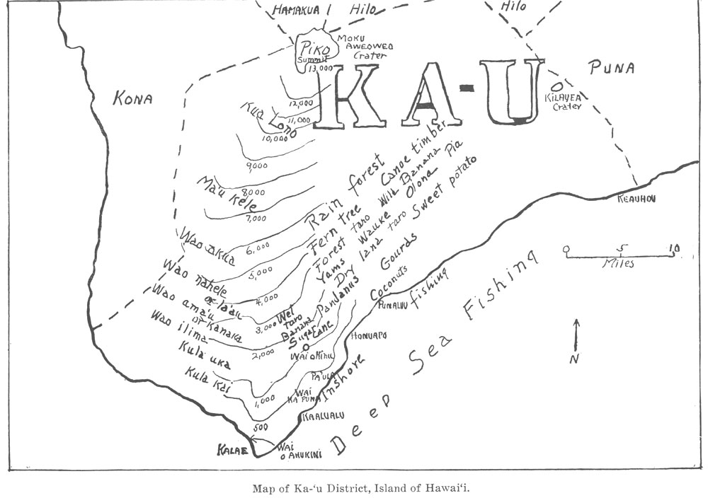
As an example, the names of the months in the district of Kāʻu on the Island of Hawaiʻi in their order illustrate the family’s seasonal activities:

ʻIkuwa (October-November)—“Loud voice”: This is the time of thunder in the uplands, wind in the lowlands, and crashing surf along shore.

The season of storm and rain was termed Hoʻoilo, including roughly the period of November through March. It commenced with ʻIkuwa, when Lono’s thunder resounds over uplands and plain.

November is a noisy month with variable strong winds; and with the wind comes the roaring and pounding surf on Kāʻu’s lava-walled shores and small steep beaches.

Welehu (November-December)—The “ashes” (lehu) of fires for cooking and warmth, as the wind swirls about the eating and work areas.

About this time, and continuing through the rainy months until March, there was and is little deep-sea fishing, and inshore fishing depended on those occasions when the sea was not too rough.

Equally, upland work, such as cutting timber, stripping bark for cloth and for fiber, collecting wild foods and hunting birds, was gradually abandoned because of the rains.

It was a time of being inside the respective homesteads: a time for work that could be done under a roof and out of the wind.

Makaliʻi (December-January)—The “little eyes” (makaliʻi) or shoots of yams, arrowroot, turmeric, looking like points or eyes (maka) are showing.

Kaʻelo (January-February)—The (ka) drenching (elo) time, as the rainy season and southerly winds culminate and subside, as northerly winds push in. This is the month when migrating birds are fat and greasy (eloelo).

Kaulua (February-March)—“Two together” (ka (the) lua (double)), i.e., partly cold and partly warm: alternating cool and warm spells. Kaulua also means “of two minds,” “indecisive”: the weather is “undecided,” so people are uncertain whether to go mauka or makai, go out or stay in.

With the ground well-soaked, and with the ending of the heavy rains that wash out the tilled soil on slopes, every household turns in February and March to the planting of their taro, sweet potato, gourds (in the lowlands,) paper mulberry and olona  for fiber (on the upper slopes,) yams and arrowroot (in the upland.)

Nana (March-April)—The word means “animation.” Life in plants shows vigor, young mother birds (kinana) are on the move, fledglings (pupua) are trying to get out of nests.

Welo (April-May)—“Vining out” (like a tail, welo): The sweet potatoes, yams, morning glory and other vines are spreading with little shoots, like tails.

During April, gardens are tended; by May plants both domesticated and wild are growing vigorously, and in May quick-growing varieties of sweet potatoes can be eaten, and wild yams and arrowroot are coming to maturity and can also be eaten. They come into their prime in late-May and June.

Ikiʻiki (May-June)—“Warm and sticky,” uncomfortable: Now there is little wind and it is humid.

This moves into the early hot season (Kau.)  This is the time when women are working at making bark cloth (kapa) at home. Men are actively hunting in the forest, fishing at sea, busy with their nets, canoes and gear at the hālau (shed) by the sea.

By June, wild foods are abundant in the forest, potatoes plentiful. Inland women-folk migrate to the shore, and there live in caves and shelters.

With their fishing baskets (hinaʻi), salt and fish baskets, mats and utensils, they catch small fish like manini spawn, collect and store salt that has dried in the pools in black lava depressions by the shore.

Kaʻaona (June-July)—“Pleasantly (ona) rolling along (kaʻa).” The serenely moving puffy clouds (kaʻalewalewa) roll along mountain and horizon. Ona means lure in fishing: figuratively, then, attractive, alluring.

Summer is the time for deep-sea fishing in particular. (In the old days, inshore fishing was restricted during spawning season, from February to late May.)

Hina-ia-ʻeleʻele (July-August)—“Dark (ʻeleʻele) clouds inclining (hina-ia) mountainwards.”

In July, gourds (and, after introduction, melons) ripen on the kula kai. It is increasingly hot and dry. Upland farmers have mulched their taro and potato patches with dried grass and fern.

August is hot, but some dark clouds appear and bring showers; as they fall, the mulch is turned back from plants, then replaced when the rain has soaked in. At the shore in caves, and at home, salt and dried fish and octopus are stored in quantity.

Then come the twin months, September-October, Mahoe-mua (Twin-before) and Mahoe-hope (Twin-behind, or after), with increasing showers and rough seas alternating with fine weather. The wild ground growths in the uplands are dying down; it is time to harvest potatoes before the heavy rains come.

Mahoe-mua (August-September)—“The twin before (first twin).”
Mahoe-hope (September-October)—“The twin behind (second twin).”
These two months, in weather, are as alike as twins. Rains and wind alternate with good weather.

It is time to be industrious at deep-sea fishing on good days, before the winter storms commence. Great pieces of the larger firm-fleshed fishes (bonito, tuna, albacore, swordfish, dolphin) are sun-dried to preserve them till eaten. Sweet potatoes are likewise preserved by cooking and sunning.  (Information here is from Handy, Handy & Pukui.)

This is the cycle – to be repeated, year after year.  The image shows the district of Kāʻu on the Island of Hawaiʻi.

© 2024 Hoʻokuleana LLC

Filed Under: Hawaiian Traditions Tagged With: Hawaii, Kau, Subsidence, Seasons

April 8, 2024 by Peter T Young Leave a Comment

Palapala Kila Nui

“Under the ancient feudal system the allodium of all lands belonged to the King, not however, as an individual, but ‘as the head of the nation, or in his corporate right,’ to quote the language of the land commission.”

“The constitution of 1840 declared that the land of the Kingdom was not the private property of Kamehameha I. ‘It belonged to the chiefs and people in common, of whom Kamehameha I was the head, and had the management of the landed property.’” (Alexander)

“[I]n 1848 a committee was appointed to effect the division between the King as feudal suzerain and the chiefs, his feudatories, which completed its work in forty days. Partition deeds were signed and sealed by the King on one side and the several chiefs on the other side, who were then entitled to receive awards from the land commission for the lands thus partitioned off to them.”

“[T]he lands held by the King at the close of the Mahele were not regarded as his private property, strictly speaking. Even before his division with the landlords a second division between himself and the Government was clearly contemplated …”

“Accordingly, on the very day after the Mahele, or division with his chiefs, was closed, viz, the 8th day of March, 1848, he proceeded ‘to set apart for the use of the Government the larger part of his royal domain, reserving to himself what he deemed a reasonable amount of land as his own estate.’”

“This latter class of lands ‘he reserved for himself and his heirs forever’ as his own private estate, and they are now known as Crown Lands.”

“On the 7th day of the following June, 1848, the legislative council passed the ‘act relating to the lands of His Majesty the King and of the Government,’ which confirms and ratifies the division which had already been made by the King, thus making it an act of the nation through its representatives.”

“In this act the said lands are designated by name, and declared ‘to be the private lands of His Majesty Kamehameha III, to have and to hold to himself, his heirs, and successors forever; and said lands shall be regulated and disposed of according to his royal will and pleasure, subject only to the rights of tenants.’” (Alexander)

“Government lands were administered by the Minister of the Interior who was empowered by law to sell and lease. As the Land Commission could only consider claims to farms and building lots arising prior to December 10, 1845, many of the people were deprived of the opportunity to secure lands for themselves.”

“So to provide for this class the Minister of Interior was authorized in the early days of the new regime to sell building lots and tracts of land from a fraction of an acre to several hundred acres, at prices ranging from twenty-five cents to one dollar an acre.”

“The Minister of Interior was also authorized to dispose of government lands by sales for many other purposes.” (King)  On July 11, 1851, an Act was passed confirming certain resolutions of the Privy Council of the previous year, which ordered …”

“‘.. that a certain portion of the Government lands on each island should be placed in the hands of special agents to be disposed of in lots of from one to fifty acres in fee simple, to residents only, at a minimum price of fifty cents per acre.’”  (Interior Department, Surveyor’s Report, 1882)

Between the years 1850 and 1860, nearly all the desirable Government land was sold, generally to Hawaiians. The portions sold were surveyed at the expense of the purchaser.  (Interior Department, Surveyor’s Report, 1882)

“Following the division of the lands into Crown, Government, and Konohiki Lands, from time to time portions of the Government Lands were sold as a means of obtaining revenue to meet the increasing costs of the Government.”

“Purchasers of these lands were issued documents called ‘Grants’ or ‘Royal Patent Grants.’ These differed from the Royal Patents issued upon Land Commission Awards.” (Chinen)

These Land Grants were given for lands that were purchased by individuals from the Hawaiian Kingdom when they were made available for purchase in mid-1800s. (UH Mānoa Library) The term used for these was Palapala Kila Nui (also Palapala Sila Nui, aka Government Grant; Royal Patent).

Royal Patent Grants (until 1893) and Land Patents conferred fee simple title to a Government land. This was an outright purchase of Government land, and not a commutation of the Government’s interest in land. The last Royal Patent was number 7992. (UH Manoa Library)

“This class of conveyance is designated a Royal Patent (Grant) and since the overthrow of the monarchy, as Land Patent (Grant). It is more commonly known as a Grant and so designated on most of the title maps.”

“These grants are recorded in a series of books now deposited in the office of the Commissioner of Public Lands. Many conveyances by the Minister of Interior were by the ordinary deed method which deeds were recorded by the grantees in the Bureau of Conveyances.”  (King)

© 2024 Ho‘okuleana LLC

Filed Under: General, Ali'i / Chiefs / Governance, Hawaiian Traditions, Economy Tagged With: Hawaii, Royal Patent Grant, Palapala Sila Nui, Palapala Kila Nui

March 27, 2024 by Peter T Young Leave a Comment

“O Ulumāheihei wale no, ia ia oloko, ia ia owaho”

“O Ulumāheihei wale no, ia ia oloko, ia ia owaho” – “Ulumāheihei knows everything inside and outside” was the saying, alluding to matters that came up at the court of the chiefs and elsewhere.

When Kamehameha I was king, Ulumāheihei was a trusted advisor. In the time of Kamehameha II he had suppressed Kekuaokalani in a rebellion after Liholiho broke the ʻai noa (free eating) kapu; he commanded the forces against a rebellion by Prince George Kaumualiʻi on Kauaʻi.  Ulumāheihei became noted as a war leader for his victory over the rebels.

Ulumāheihei was a learned man skilled in debate and in the history of the old chiefs and the way in which they had governed. He belonged to the priesthood of Nahulu and was an expert in priestly knowledge. He had been taught astronomy and all the ancient lore.  It was at the court of Ulumāheihei that the chiefs first took up the arts of reading and writing.  (Kamakau)

He was born around 1776 (the year of America’s Declaration of Independence.)  At the time, the leading chiefs under Kamehameha were Keʻeaumoku (the father of Kaʻahumanu,) Kameʻeiamoku, Keaweaheulu and Kamanawa.  (Bingham)

Ulumāheihei’s  father High Chief Kameʻeiamoku was one of the “royal twins” who helped Kamehameha I come to power – the twins are on the Islands’ coat of arms – Kameʻeiamoku is on the right (bearing a kahili,) his brother, Kamanawa is on the left, holding a spear.

In his younger years Ulumāheihei was something of an athlete, tall and robust with strong arms, light clear skin, a large high nose, eyes dark against his cheeks, his body well built, altogether a handsome man in those days.  (Kamakau)

After the conquest of Oʻahu by Kamehameha I, in 1795, he gave Moanalua, Kapunahou and other lands to Kameʻeiamoku, who had aided him in all his wars.  (Alexander)

Kameʻeiamoku died at Lāhainā in 1802, and his lands descended to his son, who afterwards became governor of Maui. Ulumāheihei’s first marriage was to Chiefess Kalilikauoha (daughter of King Kahekili of Maui Island.)  Liliha his daughter/hānai was born in 1802 or 1803.

Ulumāheihei later earned the name Hoapili (“close companion; a friend.’)

Hoapili resided several years at Punahou near the spring, from 1804 to 1811.   Hoapili gave Punahou to his daughter/hānai Liliha, who married Governor Boki.  In December, 1829, just before starting Boki’s fatal sandal-wood expedition, the Punahou land was given to Rev. Hiram Bingham, with the approval of the Queen-Regent, Kaahumanu.  (Alexander)

Testimony before the Land Commission notes, “The above land was given by Boki to Mr. Bingham, then a member of the above named Mission and the grant was afterwards confirmed by Kaʻahumanu.“  “This land was given to Mr. Bingham for the Sandwich Island Mission by Gov. Boki in 1829… From that time to these the SI Mission have been the only Possessors and Konohikis of the Land.”  (It was considered to be a gift from Kaʻahumanu, Kuhina Nui or Queen Regent at that time.)

By 1815, Kamehameha had established succession with two sons, and entrusted Ulumāheihei (Hoapili) with the care of their mother, Queen Keōpūolani. This made Ulumāheihei stepfather to Princess Nāhiʻenaʻena.   (Ulumāheihei (Hoapili) was spouse to Kalilikauoha, Keōpūolani and Kalākua.)

Like his father, he was a devoted and trusted advisor and chief under Kamehameha.  Hoapili was with Kamehameha when he died on May 8, 1819 at Kamakahonu at Kailua-Kona.

“Kamehameha was a planner, so he talked to Hoapili and Hoʻolulu (brothers) about where his iwi (bones) should be hidden,” noting Kamehameha wanted his bones protected from desecration not only from rival chiefs, but from westerners who were sailing into the islands and sacking sacred sites. (Bill Maiʻoho, Mauna Ala Kahu (caretaker,) Star-Bulletin)

Hoapili had accepted the word of God because of Keōpūolani.    After her marriage with Hoapili she became a steadfast Christian.  (Kamakau) To Kalanimōku and Hoapili (her husbands) she said, “You two must accept God, obey Him, pray to Him, and become good men. I want you to become fathers to my children.”

Hoapili welcomed the missionaries to the island and gave them land for churches and enclosed yards for their houses without taking any payment. Such generosity was common to all the chiefs and to the king as well; a tract of a hundred acres was sometimes given.  (Kamakau)  (Prior to the Māhele, title didn’t pass when land was given:title was later affirmed by the Land Commission.)

While Kamehameha was still alive he allowed Keōpūolani to have other husbands, after she gave birth to his children; Kalanimōku and Hoapili were her other husbands.  In February 1823, Keōpūolani renounced the practice of multiple spouses for royalty, and made Hoapili her only husband.

In May 1823, he and Keōpūolani moved to Maui and resided in Lāhainā; they asked for books and a chaplain so they could continue their studies. Hoapili served as Royal Governor of Maui from May 1823.

She became very weak and Rev. William Ellis baptized her by the name of Harriet Keōpūolani. Before the end of the day she was dead. Thus the highest tabu chiefess became the first Hawaiian convert.  (Kamakau)

In September, the king was summoned to Maui where the queen mother, Keōpūolani, lay dying. At her death, September 16, 1823, in Lāhainā, the chiefs and people began to wail and carry on as usual, but Hoapili forbade the custom of death companions and boisterous expressions of grief, saying, “She forbade it and gave herself to God.”  (Kamakau)

After the death of Keōpūolani, her husband, Hoapili, was the leading representative of the Christian faith.

Later Kaʻahumanu and Kalanimōku and their households followed suit.  (Kamakau)  On October 19, 1823 Hoapili married Kalākua who became known as “Hoapili-wahine.”

In 1823, Kalākua Kaheiheimālie (ke Aliʻi Hoapili wahine, wife of Governor Hoapili) offered the American missionaries a tract of land on the slopes surrounding Puʻu Paʻupaʻu for the creation of a school.  Betsey Stockton founded a school for makaʻāinana (common people) including the women and children.  The site of the school is now Lahainaluna School.

Another good work for which Hoapili is celebrated was the building of the stone church at Waineʻe. The cornerstone was laid on September 14, 1828, for this ‘first stone meeting-house built at the Islands’; it was dedicated on March 4, 1832 and served as the church for Hawaiian royalty during the time when Lāhainā was effectively the Kingdom’s capital, from the 1820s through the mid-1840s (it was destroyed by fire in 1894.)  In addition, he erected the Lāhainā fort to guard the village against rioting from the whalers off foreign ships and from law breakers.  (Kamakau)

Hoapili is also credited with improving the King’s Highway (portions also called Hoapili Trail, initially built during the reign of Pi‘ilani;) it once circumnavigated the whole island.  Hoapili commissioned road gangs for the work. The Rev. Henry Cheever noted that these road gangs were largely composed of prisoners who had been convicted of adultery; Cheever called it “the road that sin built.”  (Samson)

On January 2, 1840, Ulumāheihei (Hoapili) died in the stone house at Waineʻe.  The image shows a drawing of Hoapili by CC Armstrong.

Click here for more on Hoapili: https://imagesofoldhawaii.com/wp-content/uploads/Hoapili.pdf

© 2024 Hoʻokuleana LLC

Filed Under: Ali'i / Chiefs / Governance, Missionaries / Churches / Religious Buildings, Hawaiian Traditions, Place Names Tagged With: Hoapili, Keopuolani, Ulumaiheihei, Hawaii, Kamehameha, Maui, Punahou, Kalanimoku, Wainee

March 21, 2024 by Peter T Young Leave a Comment

Kaipalaoa

Ka niu peʻahi kanaka o Kaipalaoa.
The man-beckoning coco palms of Kaipalaoa.

(The swaying palms that once grew at Kaipalaoa, Hilo, seemed to wave an invitation. ʻŌlelo Noʻeau #1502)

Hilo is likely to have been one of the first Polynesian settlement areas on Hawai‘i Island; oral history and local legend indicate that Polynesians first settled Hilo Harbor around 1100 AD.

Early accounts of Hilo Bay describe a long black sand beach stretching along present day Bay Front from the Wailuku River to the Wailoa River.

Many heiau (temples) attested to the prosperity of Hilo. Kaipalaoa (Sea Whale) Heiau sat on the southern banks. The village at Kaipalaoa was a major trade center, where people from the northern districts met the people of the southern portions of Hilo and Puna.

Kamehameha was familiar with the Hilo district from his youth. Kaipalaoa, across the Wailuku River from Pu`u`eo was a favorite surfing area, and at least eight excellent breaks could be found from Pu‘u‘eo to Waiākea. (Yuen)

Kamehameha I began a war of conquest, winning his first major skirmish in the battle of Mokuʻōhai (a fight between Kamehameha and Kiwalaʻo in July, 1782 at Keʻei, south of Kealakekua Bay on the Island of Hawaiʻi.)  Kiwalaʻo was killed.

Captain George Vancouver, an early European explorer who met with Kamehameha at Hilo Bay in 1794, recorded that Kamehameha was there preparing for his invasion of the neighbor islands, and that Hilo was an important center because his canoes were being built there.

Desha wrote that “It is thought that there were as many as seven mano [twenty eight thousand] people who gathered at the shore at Kaipalaoa when the ali‘i landed”. The people of Hilo had long prepared for Kamehameha’s arrival and collected a large number of hogs and a variety of plant foods, to feed the ruler and his warriors.

Kelly surmised that the people of Hilo had actually prepared for a year prior to Kamehameha’s visit and expanded their fields into the open lands behind Hilo to accommodate the increased number of people that would be present.

Kelly also speculated that many of the fishponds in Waiākea were created to feed Kamehameha, his chiefs, and craftsmen. The area at Hilo Bay that housed Kamehameha’s canoe fleets continues to be the site of canoeing, both recreational and competitive. (Rechtman)

By 1795, having fought his last major battle at Nuʻuanu on O‘ahu with his superior use of modern weapons and western advisors, he subdued all other chiefdoms (with the exception of Kauai).

However, after a short time, another chief entered into a power dispute with Kamehameha; his name was Nāmakehā (the brother of Kaʻiana, a chief of Kauai who had been killed in the Battle of Nuʻuanu.)

Previously, Kamehameha asked Nāmakehā (who lived in Kaʻū, Hawai‘i) for help in fighting Kalanikūpule and his Maui forces on O‘ahu, but Nāmakehā ignored the request.

Kamehameha, on Oʻahu at the time, returned to his home island of Hawaiʻi with the bulk of his army to suppress the rebellion.  The battle took place at Kaipalaoa, Hilo.  Kamehameha defeated Nāmakehā. 

This was the final battle fought by Kamehameha to unite the archipelago.  (Kamehameha negotiated a settlement with King Kaumualiʻi for the control of Kauai and Niʻihau, in 1810.)

Although Kamehameha’s warriors had won the battle over Nāmakehā, they then turned their rage upon the villages and families of the vanquished. It was about the same time and place of the Nāmakehā Rebellion that Kamehameha decreed Ke Kānāwai Māmalahoe (The Law of the Splintered Paddle.)

When Liholiho was born at Hilo in November 1797, he was immediately taken from his mother and given to the guardianship of Kaahumanu. (Sinclair)  The first-born child of Keōpūolani and Kamehameha, his piko was ceremonially cut at Kaipalaoa, at the heiau of the same name. (Correa)

Stokes included descriptions of Kaipalaoa heiau as: “Probably located just west of Isabelle Point. The native name of this point is Kaipalaoa”. (Scheffel)

Kaipalaoa Point is now known as Cocoanut Point. “The native name of [Isabelle Point] is Kaipalaoa.” (Stokes) Isabel and Kaipalaoa points are separated by only about three hundred feet. (Hawaiian Place Names)

“The site of Kai-palaoa Heiau was on the land of Kai-palaoa, and lay just seaward, and a little toward Wai-anuenue St, from the site of the Hilo Armory at the upper end of the short street from the shore to Ke-awe St, and on the side toward the river a little below the bridge to Pu-u-eo, near the Library.”

“The Armory site was formerly occupied by the royal residence of King Ka-mehameha I, which was named Ka-hale-‘ilio-‘ole – The House Without Rats (or, commoners).” (Kekahuna)

Kaipalaoa heiau is “Near armory site, Hilo; of pookanaka class; the heiau at which Umi’s life was threatened, and the place where Kamehameha is said to have proclaimed his Māmalahoe law (Law of the Splintered Paddle). Destroyed in the time of Kuakini’s governorship of Hawaii.”  (Hawaiian Place Names)

Between 1863 and 1890 a landing wharf and US Coast Guard lighthouse were built at the foot of Waiānuenue Avenue. Passengers and freight were transported to steamers anchored in the bay. (HHF & Cultural Surveys)

By 1870, three heiau in Hilo – Kaipalaoa, Kanowa/Kanoa, and Honokawailani – were described as already being “ruins”. Lydgate describes the Hilo bay front area as it looked in 1873:

“The sea at that time came right up to the bank edge of Front street, so that in heavy weather the spray blew more or less up into the street. Along Front street tall coconut trees of great age towered up over the street.”

“From the foot of Church street extending along the beach it was open country, with the exception of one Hawaiian home, one canoe-builder’s workshop – or halau, as it is called by the Hawaiians – and a tumbled down little blacksmith shop some distance farther on.” (Hawaii County)

© 2024 Ho‘okuleana LLC

Filed Under: Ali'i / Chiefs / Governance, Hawaiian Traditions, Place Names Tagged With: Hawaii, Hilo, Keopuolani, Namakeha, Kanawai Mamalahoe, Liholiho, Kamehameha, Kaipalaoa

March 19, 2024 by Peter T Young Leave a Comment

Pueo Kahi

Na ka Pueo kahi ke aloha
Nēnē ‘au kai o Maui

Kōwelo kō hae Hawai‘i
Ma ka ‘ilikai a‘o Māmala

Mālama ‘ia iho ke aloha
I Kuleana na‘u e hiki aku au

Ha‘ina ‘ia mai ka puana
Nā ka Pueo kahi ke aloha

The Pueo is my one love
The seafaring gull of Maui

The Hawaiian flag flutters
Over the surface of Mamala Bay

Take care of my love
That’s mine until I return

The story is told
Of the ship, Pueo that I love
(Na Ka Pueo – by Samuel Kalani Kaea)

Na Ka Pueo, a song which was perhaps written by a sailor, tells of a ship named Pueo-Kahi, a cargo vessel which sailed between Hāna and Honolulu harbors during the end of the monarchy period and during the republic.

The Pueo-Kahi was named for a place near Hāna, Maui. It is an earlier name of what we now call Hāna Bay and near the birthplace of Queen Ka‘ahumanu. ‘Pueo-Kahi,’ which could be translated as ‘Lone Owl,’ was named for the owl (pueo) demigod of that area. (Hau‘oli)

Ship, boat or canoes in Hawaiian mele were used as a poetic reference to woman. Owls were also family aumakua (ancestral gods).

“[T]he ‘aumakua was represented in marine life such as great fish, mano (shark), puhi (moray eel), mo‘o (lizard), honu (turtle), and land animals such as pueo (owl).”

“Many of [the people] looked for appearances by their ‘aumakua.  For example, one informant shared that at a family funeral, his ‘aumakua, the pueo, appeared to lend support to his family.”

“The family knew where their ‘aumakua could be found and always made efforts to nurture or never harm them. … Pueo is symbolic of Wisdom and the whole universe, light and enlightenment. It is an ‘aumakua or ancestral guardian spirit.” (Matsuoka, etal)

Hāna is located on the eastern most point of Maui, approximately 60 miles from the population centers of Wailuku and Kahului. Hāna, or Kapueokahi, “the single owl”, is considered one of the most beautiful and historically important areas of Maui.

Prior to the unification of the Hawaiian Islands by King Kamehameha, Hāna was used as a staging ground for battles between warring chiefs on Maui and the island of Hawaii.  (AECOS)

Alenuihaha Channel, between the southeast and south coast of East Maui and ‘Upolu Point (the northwest tip of Hawaii) could easily be crossed in either direction in a couple of hours when a trade wind was blowing.

As a sanctuary, both in wartime and peacetime, Hāna was an ideal seat for ruling ali’i of either island, as well as a much pleasanter and more beautiful place in which to live.

“Hana is called ‘a land beloved of chiefs because of the fortress of Ka‘uiki [a high rocky hillock by the bay] and the ease of living in that place.’”

“In time of war the hill was reached by a ladder of ohia poles bound together with withes. On the summit was spread a springy plant to serve as bed. Fishponds below furnished unlimited stores of fish. Heaps of ‘awa root ‘delighted the nostrils of the dear firstborn chiefs’”. (Beckwith; Handy, Handy & Pukui)

The sugar industry transformed the ecology of Hāna beginning in 1860 with the Ka‘eleku Sugar Company that formed the backbone of Hāna’s economy until sugar production ceased in the early 1930s.

Paul Fagan bought the sugarcane plantation, converting the area into cattle ranching, and in 1946, built the exclusive Hotel Hāna Ranch, historically known as Hotel Hāna Maui and today as Travaasa Hāna.

The pier at Hāna Bay (also historically known as Kauiki Bay ca. 1920, and as Kapueokahi Bay ca. 1882) was completed in the first half of 1921.

It replaced an earlier landing located near the foot of Keawa Place, on the shore of Hāna Bay, about 250 yards to the west. Here, a series of landings, jetties, and a pier had been in use since at least 1882.

When the 1921 structure was built, it was referred to as “Hāna Wharf”, not as a pier (as it is known today). As such, the historical context that follows uses the historically accurate terms “wharf” and “Hāna Wharf” to describe what is now known as Hāna Pier. (AECOS)

© 2024 Ho‘okuleana LLC

Filed Under: General, Ali'i / Chiefs / Governance, Hawaiian Traditions, Place Names Tagged With: Hawaii, Hana, Pueo Kahi, Hana Bay

  • « Previous Page
  • 1
  • …
  • 17
  • 18
  • 19
  • 20
  • 21
  • …
  • 100
  • Next Page »

Images of Old Hawaiʻi

People, places, and events in Hawaiʻi’s past come alive through text and media in “Images of Old Hawaiʻi.” These posts are informal historic summaries presented for personal, non-commercial, and educational purposes.

Info@Hookuleana.com

Connect with Us

  • Email
  • Facebook
  • LinkedIn
  • Twitter
  • YouTube

Recent Posts

  • Prince Jonah Kūhiō Kalanianaʻole Piʻikoi
  • Tutasi
  • Lurline
  • About 250 Years Ago … ‘Give Me Liberty, Or Give Me Death’
  • About 250 Years Ago … Stamp Act
  • Telling Time
  • Arterials

Categories

  • General
  • Ali'i / Chiefs / Governance
  • Buildings
  • Missionaries / Churches / Religious Buildings
  • Hawaiian Traditions
  • Military
  • Place Names
  • Prominent People
  • Schools
  • Sailing, Shipping & Shipwrecks
  • Economy
  • Voyage of the Thaddeus
  • Mayflower Summaries
  • American Revolution

Tags

Albatross Al Capone Ane Keohokalole Archibald Campbell Bernice Pauahi Bishop Charles Reed Bishop Downtown Honolulu Eruption Founder's Day George Patton Great Wall of Kuakini Green Sea Turtle Hawaii Hawaii Island Hermes Hilo Holoikauaua Honolulu Isaac Davis James Robinson Kamae Kamaeokalani Kameeiamoku Kamehameha Schools Lalani Village Lava Flow Lelia Byrd Liberty Ship Liliuokalani Mao Math Mauna Loa Midway Monk Seal Northwestern Hawaiian Islands Oahu Papahanaumokuakea Marine National Monument Pearl Pualani Mossman Quartette Thomas Jaggar Volcano Waikiki Wake Wisdom

Hoʻokuleana LLC

Hoʻokuleana LLC is a Planning and Consulting firm assisting property owners with Land Use Planning efforts, including Environmental Review, Entitlement Process, Permitting, Community Outreach, etc. We are uniquely positioned to assist you in a variety of needs.

Info@Hookuleana.com

Copyright © 2012-2024 Peter T Young, Hoʻokuleana LLC


Loading Comments...