Kahuku is the largest of the 1300 ahupuaʻa (traditional land divisions) in Hawaiʻi. Located in the vast Kaʻū district, the ahupuaʻa of Kahuku originally extended from the summit caldera of Mauna Loa to the sea. (NPS)
The oldest dated feature within Kahuku is from about 1400 AD, though older evidence has been found nearby near Ka Lae (South Point).
Widespread settlement in this dry, volcanic area came later than in most parts of Hawai’i. By the mid-1400s, Ka‘ū (and perhaps Kahuku) had intensively managed agricultural fields in mid-elevation land with adequate rain and soil. Food crops included sugar cane, ʻuala, and maiʻa (bananas). (NPS)
Kahuku pali has two Hawaiian names: Pali o Mamalu, for its mauka (inland) section, and Pali‘okūlani, for its makai (seaward) section. It was formed by a geologic fault. Its average height is 400 ft, but its maximum height, which is equal to the amount of offset (movement) on the fault, is approximately 560 ft.
The origin of the Kahuku pali is still debated. One hypothesis is that the pali is a scissors fault, with zero offset above Highway 11 and increasing amounts of offset toward the south—similar to the way the two cutting surfaces of scissors get farther apart as you move from hinge to tip. On the Kahuku pali, the west side of the fault dropped down relative to the east side.
An alternate hypothesis is that the submarine portion of the pali is the headwall of a catastrophic landslide, with the west side falling away and leaving the mile-high scarp. Both hypotheses have pros and cons, and today, there is no definitive answer as to the origin of the pali. (USGS)
“In the lee of the great cliff (which was caused by a geologic fault) named Pali-o-Mamalu (Cliff-of-Protection) is Wai-o-‘Ahu-kini. The trade winds pass a thousand or more feet above it, which gives it a scorching desert climate in the daytime; but when the sun goes down it cools rapidly and the nights are cool.”
“Southerly cyclonic storms sweep in over the low shore, inundating the whole area. That is why there is, and has been, no permanent habitation here.” (Handy, Handy & Pukui)
“(T)he population settled in the two western ahupua‘a of Ka‘ū. Wai-o-‘Ahu-kini (Water of Ahukini) close by, with its spring, pond, and canoe haven, and the best fishing ground in all Hawaii …”
“… was awarded in the ancient land allotment to Pakini, then one of the most verdant of the plains areas of cultivation. Doubtless it was Pakini’s numerous population, which gave its ali‘i power, that was responsible for this award.”
“From the cliff above Wai-o-‘Ahu-kini and from the trail going down can be seen a stagnant pool close to the shore; this was evidently the ‘water’ of ‘Ahu-kini.” (Handy, Handy & Pukui)
Cooks’ journal entry for January 5, 1779; reported his ship had rounded the south point of the island … “On this point stands apritty large village, the inhabitants of which thronged off to the Ship with hogs and women … As we had now got a quantity of salt I purchased no hogs but what were fit, for salting, refuseing all that were under size …”
“… in general they being no other at first, but when they found we took none but the large ones, several went a shore and returned with some, however we could seldom get one about 50 or 60 Ib weight.”
“As to fruit and roots we did not want and it was well we did not for it was very little of either they brought with them, indeed the Country did not seem capable of producing many of either having been destroyed by a Volcano.” (Cook’s Journal)
“Some of the canoes that greeted Cook’s ship may have come not only from the South Point village, but also from those at Wai‘ahukini and Ka‘iliki‘i to the west and Keana and Kaalualu to the east.” (Kelly)
“One of the earliest foreigners to visit Ka‘ū was Archibald Menzies, the surgeon and naturalist on Vancouver’s voyage. Menzies had been in the Hawaiian Islands previously as surgeon on the furtrader Prince of Wales under Captain Colnett in the years 1787 and 1788, but he had not kept a journal of that visit.”
“Vancouver’s ships were in the Islands three times – 1792, 1793, and 1794. “On the 1794 trip Menzies was able to get to the top of Hualālai and of Mauna Loa. His successful ascent of Mauna Loa was on a trail that leads up from Kapāpala.”
“The approach to this trail from Kona, where Vancouver’s ships were anchored, was by canoe to Ka‘iliki‘i, or Wai‘ahukini in Pi‘ikini, Kalli, and then overland on foot to Kapāpala.” (Kelly)
Menzies, on his way to be the first white man to reach the summit of Mauna Loa, climbed the pali … “we left our canoes at Pakini and set out early on the morning of the 10th [of February 1794] to prosecute the remainder of our journey by land.”
“We had not travelled far when we found we had to ascend an elevated steep rugged bank that took its rise at the south point of the island and running along the southern side of Pakini Bay continued its direction inland behind the village.”
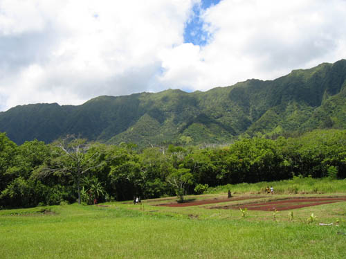
“On gaining its summit, which was not an easy task, an extensive tract of the most luxuriant pasture we had yet seen amongst these islands rushed at once upon our sight, extending itself from the south point to a considerable distance inland.”
“It was cropped with fine soft grass reaching up to our knees, and naturally of a thick bottom that would afford excellent feeding for cattle, where herds of them might live at their ease, if it was not for scarcity of fresh water, which we experienced in all the low grounds we had yet visited….”
“Close by us was a fine plantation belonging to Kamehameha, called Kahuku, where our purveyor was particularly ordered to demand supplies for our journey …” (Menzies)
“In the afternoon we resumed our journey and soon after reached the upper plantations, when instead of ascending directly up the mountain as we expected, they led us across these plantations to the north-eastward at a distance of five or six miles from the shore by a narrow winding path which in some places was very rugged and seldom admitted more than one person at a time …”
“… so that we followed one another in a string, and occupied a considerable space in length from the number of our party and the crowds that followed us from village to village through curiosity and flocked to see us, from far and near.”
“This path we found to be the public road leading to the east end of the island, and at small eminences here and there, we met cleared spots for resting on, where the wearied travellers generally sit down to chew sugar cane and admire the surrounding prospect.” (Menzies)