Images of Old Hawaiʻi

  • Home
  • About
  • Categories
    • Ali’i / Chiefs / Governance
    • American Protestant Mission
    • Buildings
    • Collections
    • Economy
    • Missionaries / Churches / Religious Buildings
    • General
    • Hawaiian Traditions
    • Other Summaries
    • Mayflower Summaries
    • Mayflower Full Summaries
    • Military
    • Place Names
    • Prominent People
    • Schools
    • Sailing, Shipping & Shipwrecks
    • Voyage of the Thaddeus
  • Collections
  • Contact
  • Follow

September 26, 2025 by Peter T Young Leave a Comment

Malukukui

“The Kukui Tree would pay big in the hands of anyone who could got a liquor license, or who would run a blind pig. … EP Irwin has decided to close the Kukui Tree, at Wahiawa. …”

“The place has not been paying. Mr. Irwin will devote all his attention now to his Waikiki place, the well known Hau Tree.” (Hawaiian Star, July 17, 1911)

Let’s look back …

Mr and Mrs Henry C Brown converted their Wahiawa home into the “Malukukui, their home-hotel among the pineapples at Wahiawa.” (Hawaiian Gazette, September 29, 1909)

“(I)ll health sent them to seek a quiet country life. They settled in Wahiawa, the largest pineapple country in the world, where they bought several acres of ground and built their home, evolving from it a small country inn in which they are now able to accommodate some fifty guests.”

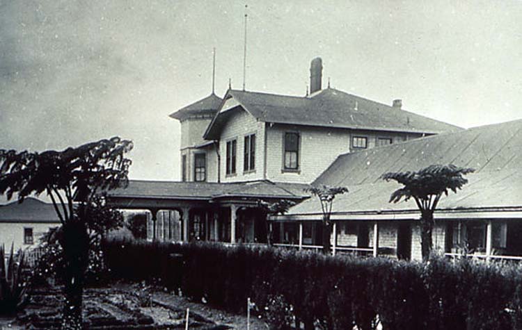
“The house was built by Japanese carpenters and has some Japanese features; for example, the bedrooms on the sheltered side of the house have no glass in the windows, but only sliding screens and shutters which fold up on the outside to be used in the case of heavy rain.”

“The house is built of matched boards left rough on the outside but planed within, and over each joint, both inside and out, three-inch battens are laid. The roof is of galvanized iron, roofing much used in this district, and the whole is stained a dark moss green with white trimmings about the windows and doors.”

“Every room has a fine view either over the restful pineapple fields or down the deep ravine on the edge of which the house is built. In the distance can be seen magnificent mountain ranges and glimpses of the Pacific ten miles distant.”

“The house is of significance to us, not alone because of its attractiveness or the fact that many of the ideas for which we stand have been put into practice within it; but as an example of what can be done in a country where there are few resources, by people who really desire to build a home after their own hearts.” (The Craftsman, 1909)

Wahiawa Hotel operated under the American plan, $2.50 upward per day; $15 upward per week; $45 upward per month. (Aloha Guide, 1915)

“Wahiawa is 25 miles from town by rail. It is the original pineapple district founded by a colony of American agriculturists in 1899. It is a small village surrounded by pineapple fields, and being of an elevation of 1000 feet offers to pleasure-seekers and those seeking the cool atmosphere, recreation and rest.” (Aloha Guide, 1915)

It “also (has) several stores, markets, shops, laundry, etc., and two pineapple canneries. Now that the mails come twice a day by rail instead of twice a week by stage from Pearl City, as was the case formerly, a number of Honolulu people have built country houses.” (Paradise of the Pacific, Oct/Nov 1905)

“The Hawaiian Islands Pineapple cannery is located here and may be inspected whenever it is running, the height of the canning season being from July to September.”

“Oahu Railway & Land Co … which obtained its franchise in 1888 operates a narrow gauge railway from Honolulu as far as Kahuku, a distance of 71 miles with a branch line to Wahiawa (13 miles), the pineapple district and to Leilehua, the army post.” (Aloha Guide, 1915)

“A large dam has been constructed here for the purpose of storing up water for the Waialua Sugar Plantation.” (Aloha Guide, 1915) “Motor-boating on fresh water is one of the attractions of Wahiawa.”

“The Wahiawa Water Company, desiring to conserve the ten billion gallons of water which annually flowed through the Kaukonahua streams, for use on Waialua sugar-cane lands, spent over a quarter of a million dollars building a dam and system of ditches and tunnels.”

“Forty-seven million gallons was Waialua’s daily allowance recently during the planting season—a good help to dividends. The dam backs water three and one-half miles up one branch and four and one-half of the Wahiawa Colony, whence it passes through the holdings of all the colonists, giving them means of irrigating at moderate rates. Recently a pipe system has been installed, removing all fears of dry weather.” (Paradise of the Pacific, Oct/Nov 1905)

“The lease giving EP Irwin the control of the Wahiawa country resort formerly the Malukukui Hotel was signed yesterday by the trustees of the Atherton estate and the new proprietor took possession at once.”

“Numerous expensive additions and repairs about the place have been already planned and will be immediately executed increasing the capacity of the hotel and making it cosier and nearer the standards of the comfort in city hostelries.”

“An automobile will meet the trains at Wahiawa from the hotel and in its off moments act as a link between the Hau tree Irwins Waikiki Hotel and his new Wahiawa enterprise.” (Hawaiian Gazette, March 7, 1911)

“The Kukui Tree, formerly known as Malukukui, at Wahiawa, is now open and ready to receive guests. Extensive Improvement are under way and will soon be completed. No place in Hawaii is as suitable to spend a week end at as the Kukui Tree.”

“Run up today or tomorrow and stay over Sunday and see if this is not true. If you try it once, The Kukui Tree will become a habit with you. The table is excellent, as are the accommodations. Inquiries may be made of EP Irwin, at the Hau Tree, phone 1389.” (Hawaiian Star, March 24, 1911)

“The necessity for a place such as Mr Irwin has reopened exists and he deserves all the patronage his enterprise should bring him. As managers of the Hau Tree at Waikiki, Mr and Mrs Irwin have demonstrated the fact that they know how. (Hawaiian Gazette, March 24, 1911)

However, as noted in the initial quote, “The place has not been paying (and) EP Irwin has decided to close the Kukui Tree, at Wahiawa.” There is limited mention of the Malukukui or the Kukui Tree after that.

© 2025 Hoʻokuleana LLC

Filed Under: Buildings, Economy Tagged With: Hawaii, Oahu, Wahiawa, Malukukui

September 25, 2025 by Peter T Young Leave a Comment

Fight for Parker Ranch

Within a few years after John Palmer Parker arrived in the Islands from Massachusetts in 1809 (he was then age 19), he had established a relationship with King Kamehameha I and received exclusive permission to hunt the wild cattle roving the countryside.  (Paniolo Preservation Society)

Back then, carcasses were carried down the mountain slopes on the backs of Hawaiians. At a nearby port, the skins were turned over to King Kamehameha’s advisor. Hides were used in trading and the meat supplied the King’s ships. Later the whalers took on meat, tallow and hides. (Purdue Agriculturalist)

John Palmer Parker married Kipikane, the granddaughter of King Kamehameha. They had two sons, John II and Ebenezer, and a daughter, Mary Ann Kaulalani Parker. (Tracy)

John’s first property was in a remote area on the slopes of Mauna Kea, where he built a home that reminded him of the New England neighborhood where he grew up. Mana Hale (House of the Spirit) became a two-story Cape Cod “salt box” house, with a steep slate roof and plain white walls, small windows and a dormer.

It was almost completely made of koa wood: the narrow “ship style” staircase, three bedrooms, sitting rooms and great room, floors to ceilings, including much of the furniture. (Paniolo Preservation Society)

Kipikane had a dowery of 640 acres, and John bought 1,000 more acres the following year for 75 cents per acre; he continued to buy more land. (Tracy)

When John died in 1868, he willed half of the Parker property each to son John II and grandson Samuel Parker (son of Ebenezer – Ebenezer died in 1855). In 1879, John II purchased the “Hawaiian Victorian” mansion, Puuopelu. Originally built in 1862 by Englishman Charles Notley, Puuopelu became the heart of Parker Ranch.   (Paniolo Preservation Society)

John II adopted Samuel’s son John III to be heir of his half of the Ranch; John III married Elizabeth Jane Lanakila Dowsett but died shortly after his daughter, Annie Thelma Kahilu‘onāpua‘api‘ilani Parker, was born and his half of the estate was put in trust for their daughter, Thelma. (Tracy)

“[F]ollowing the death of JP Parker II in 1891, there was growing tension between Samuel Parker, estate trustees, and JP Parker III. The latter Parker died in 1894”. (Maly)

“On October 14, 1895, AW wed Elizabeth Hartwell, daughter of Judge and Mrs AS Hartwell, at the home of the bride’s parents in Honolulu. This marriage produced four children: Alfred ‘Hartwell,’ Edith ‘Edie’ Millicent (later Mrs H Ernest Podmore), Dorothy, who died at age sixteen, and Barbara Juliette.” (Bergin)

“While he maintained a law office in Honolulu, it became increasingly evident that AW yearned to be a rancher. On December 20, 1897, he wrote to Louis Von Tempsky, a prominent Maui landholder and rancher: ‘You may not be aware that I have contemplated becoming a ranchman myself.’”

“On January 28, 1898, AW realized his dream by leading a group of business partners in the purchase of Molokai Ranch. The group was incorporated as the American Sugar Company, with an interest in continuing ranching in part while building a sugar plantation.” (Bergin)

Elizabeth sought out and hired Honolulu attorney and former judge Alfred Wellington “AW” Carter to manage the Ranch on Thelma’s behalf. (Paniolo Preservation Society)

“On September 25, 1899, AW Carter was appointed guardian and trustee of Thelma Parker … In accepting the appointment as guardian and trustee, AW relinquished several opportunities that other men would have found difficult to abandon …”

“… a lucrative law career in the burgeoning city of Honolulu, president of Charles R. Bishop Trust, an executive career with Bishop Bank, deputy attorney general, judge of the First Circuit Court, and trusteeship of Bernice Pauahi Bishop’s estate.” (Bergin)

“When AW assumed the reins of the ranch, the combined total of fee simple land owned by Thelma K Parker and her natural grandfather Sam Parker amounted to only some 34,000 acres, with large parcels under lease.”

“AW was immediately concerned that if neighboring ranchers acquired those leases, it would be necessary to dispose of a large part of the cowherd. In the short span of a dozen or so years, the fee simple holdings of Parker Ranch grew to 314,000 acres. Strategic government leases also were acquired.”  (Bergin)

By 1902, Sam Parker, his cousin Eben Low, and backers, set in motion plans to take over the ranch and remove AW Carter from the role as trustee. Their first action was to contest Carter’s trusteeship of Annie Thelma K Parker. (Maly)

In 1903, “Sam approached AW with an offer to be bought out of his one-half interest of the entire ranch. The next day, AW offered him $600,000, and Sam left to think it over.”  (Bergin)

“There were several things in the air that caused AW to believe that Sam was mounting a hostile takeover of the entire ranch instead of accepting his $600,000 offer.” (Bergin)

“Things got so heated between Samuel Parker and AW Carter, that a take over was attempted, and on June 7th, 1904, Eben Low, JA Magoon, and J Lightfoot stormed Carter’s office, with Low apparently brandishing his pistols. Things were heated, but no shots were fired.”  (Maly)

On July 27, 1904, John S (Jack) Low filed a petition asking for the removal of Alfred W Carter, as guardian of the estate of Annie T. K. Parker. (Carter v. Gear, 197 U.S. 348 (1905), US Supreme Court)  “A consortium made up of Sam Parker, Eben Low, Alfred Magoon, and Fred Wunderberg, who had Sam’s power of attorney, was behind this scheme.” (Bergin)

“The case was decided on November 3, 1905 in favor of AW Carter as trustee; and the case regarding partition of assets was decided in September 1906, thus bringing an end to more than five years of disagreements and litigation.” (Maly)

In 1906, Sam Parker sold his interest to Thelma Parker’s trust, and she became to the sole heir to the Parker Ranch. Thelma Parker married Henry Gaillard Smart when she was eighteen and had one child, Richard Smart, who survived her (a daughter died young).

In 1913, Richard Palmer Smart was born to Thelma and Henry. In 1914, both Thelma and Henry Smart died before Richard was two years old. Richard Smart, [the] last remaining heir to the Parker Dynasty, took over Ranch operations from Hartwell Carter, son of AW Carter during the middle of the 20th century. (South Kohala CDP)

Richard Smart died in 1992. In his will, Smart bequeathed most of Parker Ranch’s assets to the Parker Ranch Trust Foundation. The Parker Ranch Trust Foundation’s mission is to …

“Provide perpetual support for designated beneficiaries engaged in healthcare, education, and charitable support through the sound management of Trust assets while remaining mindful of the needs of the Kamuela community and its unique quality of life.”

Smart designated five beneficiaries: North Hawai‘i Community Hospital, Lucy Henriques Medical Center, Parker School Trust Corporation, Hawai‘i Preparatory Academy, and the Richard Smart Fund of the Hawai‘i Community Foundation. (South Kohala CDP)

© 2025 Ho‘okuleana LLC

Filed Under: Economy, Place Names, Prominent People Tagged With: Parker Ranch, Eben Low, Samuel Parker, Mana, AW Carter, Thelma Parker, John Palmer Parker, Puuopelu, Hawaii

September 22, 2025 by Peter T Young Leave a Comment

Unexpected Partners

Lorrin Andrews Thurston was born on July 31, 1858 in Honolulu. His father was Asa Goodale Thurston and Sarah Andrews. On his father’s side he was grandson of Asa and Lucy Thurston of the Pioneer Company of missionaries; on his mother’s side, he was grandson of another early missionary, Lorrin Andrews.

Thurston was fluent in the Hawaiian language and gave himself the nickname Kakina. He attended Oʻahu College (Punahou,) and, later, law school at Columbia University.

He followed his father and became a member of the Hawaiʻi Legislature. In 1887, Thurston authored what became known as the Bayonet Constitution. He became the Minister of Interior.

In 1892, Thurston led the Annexation Club and participated in the revolution and overthrow of the constitutional monarchy (1893.) Thurston headed the commission sent to Washington DC for American annexation. (Smith)

A volcano enthusiast, in his childhood on Maui, he would act as an informal tour guide; Thurston first visited Kīlauea on the Island of Hawaiʻi in 1879 at the age of 21 with Louis von Tempsky. Thurston wrote that “we hired horses in Hilo and rode to the volcano, from about eight o’clock in the morning to five in the afternoon.” (NPS)

Ten years later Thurston’s first mark upon the Volcano landscape appeared. In 1889, using his position as Minister of the Interior, he oversaw the construction of an improved carriage road from Hilo to Volcano.

The road was completed in 1894 allowing four-horse stages to transport visitors from Hilo to Volcano in seven hours. This feat would greatly increase the number of people able to view the volcano at Kīlauea. (NPS)

In 1891, Thurston bought the Volcano House in the Island of Hawaiʻi.

George Lycurgus first left his native Sparta in Greece around 1876, when he was about 17 years old. He served in the Greek Army for 18 months. George sailed from Greece to Liverpool sometime in 1880 and from there docked in New York. Here the young boy, not knowing any English, started out by selling lemons.

The later found himself in San Francisco; however his brother John and a cousin, Peter Kamarinos, were in Hawaiʻi. By the fall of 1889, George was sailing on the ‘Australia’ to Hawaiʻi.

Lycurgus opened the California Wine Company in Honolulu. Another Lycurgus enterprise in Honolulu during those years was the Union Grill. He then got in the hotel business, with the ‘Sans Souci’ in Waikiki. (Maggioros)

“In 1893 Sans Souci was a rambling hostelry, nestled among the coconut and palm trees of Waikiki Beach. The guests occupied small bungalows, thatched-roof affairs about ten by twelve, the bed being the principal article of furniture. It was in one of these bungalows that Stevenson had established himself, propped up with pillows on the bed in his shirt-sleeves.” Scribner’s Magazine, August, 1926.

Lycurgus was a royalist and was implicated with other counter-revolutionists in supplying arms (1895.) He was arrested, thirteen counts of treason were filed against him and he was held at ‘The Reef’ (Oʻahu Prison) for 52-days. (Chapin)

Later, Thurston sold the Volcano House to Lycurgus. (Smith)

Starting in 1906, Thurston, a revolutionist, and Lycurgus, a counter-revolutionist, started to work together to have the volcano area made into Hawaiʻi Volcanoes National Park.

In January 1912, geologist Thomas Jaggar arrived to investigate the volcano. A building for scientific instruments was built in a small building next to the hotel. Jaggar stayed in Volcano for the next 28 years.

Thurston and Lycurgus were instrumental in getting the volcano recognized as Hawaiʻi Volcanoes National Park. On August 1, 1916, President Woodrow Wilson signed the country’s 13th National Park into existence – Hawaiʻi National Park. At first, the park consisted of only the summits of Kīlauea and Mauna Loa on Hawaiʻi, and Haleakalā on Maui.

Eventually, Kilauea Caldera was added to the park, followed by the forests of Mauna Loa, the Kaʻu Desert, the rain forest of Olaʻa and the Kalapana archaeological area of the Puna/Kaʻu Historic District.

The National Park Service, within the federal Department of Interior, was created on August 25, 1916 by Congress through the National Park Service Organic Act.

In 1916, Thurston, recognizing the long tradition of soldiers and sailors who had visited the area, proposed the establishment of a military camp at Kīlauea. Thurston promoted his idea and was able to raise enough funds through public subscription for the construction of buildings and other improvements. By the fall of 1916, the first group of soldiers arrived at Kīlauea Military Camp (KMC.) (NPS)

Later, in the 1930s, the Civilian Conservation Corps (CCC) built research offices, hiking trails and laid the foundations for much of the infrastructure and roads within the Hawaiʻi Volcanoes and other parks across the country.

On, July 1, 1961, Hawaiʻi National Park’s units were separated and re-designated as Haleakalā National Park and Hawaiʻi Volcanoes National Park.

© 2025 Hoʻokuleana LLC

Filed Under: Economy, General, Buildings, Prominent People Tagged With: Hawaii, Hawaii Volcanoes National Park, Lorrin Thurston, George Lycurgus

September 20, 2025 by Peter T Young Leave a Comment

Cane Trash

When we were kids and went fishing (trolling), I remember the frustrating – and repeated – need to pull in and clean the lines from floating bagasse (cane trash) that entangled at the lures.

It wasn’t a new thing, floating masses of bagasse have littered beaches/shorelines, affected fishers, and impacted marine resources for decades before.  Several attempts to use bagasse rather than dump it (fuel to operate the mill, canec, etc) helped, but it wasn’t until the 1970s that the dumping finally stopped.

Sugar was a canoe crop; the early Polynesian settlers to Hawaiʻi brought sugar cane with them and demonstrated that it could be grown successfully in the islands.

In pre-contact times, sugarcane was not processed as we know sugar today, but was used by chewing the juicy stalks.  Its leaves were used for inside house thatching, or for outside (if pili grass wasn’t available.) The flower stalks of sugar cane were used to make a dart, sometimes used during the Makahiki games. (Canoe Crops)

The first written record of sugarcane in Hawaiʻi came from Captain James Cook, at the time he made initial contact with the Islands.

On January 19, 1778, off Kauai, he notes, “We saw no wood, but what was up in the interior part of the island, except a few trees about the villages; near which, also, we could observe several plantations of plantains and sugar-canes.”  (Cook)

Cook notes that sugar was cultivated, “The potatoe fields, and spots of sugar-canes, or plantains, in the higher grounds, are planted with the same regularity; and always in some determinate figure; generally as a square or oblong”.  (Cook)

Sugarcane, a tall perennial grass, is grown in tropical and semitropical climates. (USDA)  “Sugar cane, described in botany as Saccharum officinarum, is a giant-stemmed perennial grass that grows from eight to twenty-four feet long. … As a rule, sugar cane consists of about eighty-eight per cent of juice and twelve per cent of fiber”. (Rolph)

The first reported processing of sugar was noted … “in 1802 sugar was first made at these islands, by a native of China, on the island of Lanai.  He came here in one of the vessels trading for sandal wood, and brought a stone mill, and boilers, and after grinding off one small crop and making it into sugar, went back the next year with his fixtures, to China.”  (Torbert; Polynesian, January 31, 1852)

As production grew, the early sugar ventures were either Hawaiian-owned or regulated by Hawaiian rulers.  In most instances, the Hawaiian-owned sugar processing was managed by either Chinese sugar boilers or American shopkeepers in rural districts.  (MacLennan)  Although sugar cane had grown in Hawaiʻi for many centuries, its commercial cultivation for the production of sugar did not occur until 1825.

In that year, John Wilkinson and Governor Boki started a plantation in upper Mānoa Valley. Within six months they had seven acres of cane growing, and by the time Wilkinson died, in September 1826, they had actually manufactured some sugar. The sugar mill was later converted into a distillery for rum, prompting Kaʻahumanu to have the cane fields destroyed around 1829.  (Schmitt)

Shortly thereafter, King Kamehameha III, seeking to encourage commercial cultivation of sugar by native Hawaiians offered the “acre system,” giving “out small lots of land, from one to two acres, to individuals for the cultivation of cane.”

“When the cane is ripe, the King finds all the apparatus for manufacturing & when manufactured takes the half. Of his half one fifth is regarded as the tax due to the aupuni (government) & the remaining four fifths is his compensation for the manufacture. These cane cultivators are released from all other demands of every description on the part of chiefs.”  (Armstrong (1839;) MacLennan)

About this time, the initial signs of commercial sugar are found on Maui, in Wailuku.  In 1840, the King ordered an iron mill from the US, and it was erected by August.  Hung & Co in 1841 advertised the sale of sugar and sugar syrup from its 150-acre plantation in Wailuku. More than likely, this was sugar from the King’s Mill.  (MacLennan)

Early plantations were small and didn’t fare too well.  Soon, most would come to realize that “sugar farming and sugar milling were essentially great-scale operations.”  (Garvin)

Then, the King sought to expand sugar cultivation and production, as well as expand other agricultural ventures to support commercial agriculture in the Islands.  In a speech to the Legislature in 1847, the King notes:

“I recommend to your most serious consideration, to devise means to promote the agriculture of the islands, and profitable industry among all classes of their inhabitants. It is my wish that my subjects should possess lands upon a secure title; enabling them to live in abundance and comfort, and to bring up their children free from the vices that prevail in the seaports.”

“What my native subjects are greatly in want of, to become farmers, is capital with which to buy cattle, fence in the land and cultivate it properly. I recommend you to consider the best means of inducing foreigners to furnish capital for carrying on agricultural operations, that thus the exports of the country may be increased …”  (King Kamehameha III Speech to the Legislature, April 28, 1847; Archives)

A few things helped kick-start this vision – following finding gold in 1848, the California gold rush stimulated a small boom in commercial agriculture for the Islands – particularly in potatoes and sugar.  However, by the end of the 1850s, the boomlet became a depression (California started to supply its own needs.)

The American Civil War virtually shut down Louisiana sugar production during the 1860s.  Hawaiian-grown sugar soon replaced much of this southern sugar through the duration of the conflict.

By the end of the war, over thirty extremely prosperous plantations were in operation and expanded to new levels previously unheard of before the war’s commencement. 

Hawaiʻi’s industrial plantations began to emerge at this time (1860s;) they were further fueled by the Treaty of Reciprocity – 1875 between the United States and the Kingdom of Hawai‘i eliminated the major trade barrier to Hawai‘i’s closest and major market.

A century after Captain James Cook’s arrival in Hawaiʻi, sugar plantations started to dominate the landscape.  Hawai‘i’s economy turned toward sugar in the decades between 1860 and 1880; these twenty years were pivotal in building the plantation system. 

The industry came to maturity by the turn of the century; the industry peaked in the 1930s. Hawaiʻi’s sugar plantations employed more than 50,000 workers and produced more than 1-million tons of sugar a year; over 254,500-acres were planted in sugar.

Sugarcane is crushed in the mill to extract and process the sugar.  Several waste products are produced by the sugar industry – one was bagasse (the fibrous residue that remains after sugarcane stalks are crushed to extract the juice), and the mills would flume it out of the mill and simply dump it in the ocean.

Later, some of the bagasse was made into fiber board.  In 1929, Hawaiian Cellulose Ltd, a subsidiary of the Waiākea Mill Company applied for a patent for the manufacture of it.  (County of Hawai‘i)  They made ‘canec.’

Canec was originally the brand name for pressed fiber board made by Hawaiian Cane Products, Ltd, but it became commonly used to refer to all pressed board of this type.

Also, later, “After passing through the last mill, as much cane pulp (bagasse) as needed is fed into the mill fireroom for use as fuel.”  (EPA)  The bagasse was pelletized and fueled the boiler.

In 1971, ecological studies of coral communities along the Hamakua Coast of the island of Hawaii resulted in the instigation of a number of Environmental Protection Agency restrictions regarding ocean disposal by sugar mills.

These included, among other things, the elimination of bagasse discharge into the ocean and significant reductions in total suspended solid (TSS). Compliance with EPA standards was achieved in 1979. (Grigg)

Mats of bagasse no longer clogged and smothered rocky bottom habitats. Also mats of bagasse on the ocean surface no longer fouled fishing boats and fishing gear. (Grigg)

© 2025 Ho‘okuleana LLC

Filed Under: Economy Tagged With: Sugarcane, Bagasse, Cane Trash, Hawaii, Sugar

September 18, 2025 by Peter T Young Leave a Comment

Spanish Lake

While there is only one global ocean, the vast body of water that covers 71 percent of the Earth is geographically divided into distinct named regions. The boundaries between these regions have evolved over time for a variety of historical, cultural, geographical, and scientific reasons.

Historically, there are four named oceans: the Atlantic, Pacific, Indian, and Arctic. However, most countries – including the United States – now recognize the Southern (Antarctic) as the fifth ocean. The Pacific, Atlantic, and Indian are the most commonly known. (NOAA)

The first Europeans to arrive in North America were likely the Norse, traveling west from Greenland, where Erik the Red had founded a settlement around the year 985. In 1001 his son Leif is thought to have explored the northeast coast of what is now Canada and spent at least one winter there.

While Norse sagas suggest that Viking sailors explored the Atlantic coast of North America down as far as the Bahamas, such claims remain unproven. In 1963, however, the ruins of some Norse houses dating from that era were discovered at L’Anse-aux-Meadows in northern Newfoundland, thus supporting at least some of the claims the Norse sagas make.

Portuguese mariners built an Atlantic empire by colonizing the Canary, Cape Verde, and Azores Islands, as well as the island of Madeira. Merchants then used these Atlantic outposts as debarkation points for subsequent journeys.

From these strategic points, Portugal spread its empire down the western coast of Africa to the Congo, along the western coast of India, and eventually to Brazil on the eastern coast of South America.

It also established trading posts in China and Japan. While the Portuguese didn’t rule over an immense landmass, their strategic holdings of islands and coastal ports gave them almost unrivaled control of nautical trade routes and a global empire of trading posts during the 1400s.

The history of Spanish exploration begins with the history of Spain itself. During the fifteenth century, Spain hoped to gain advantage over its rival, Portugal. The marriage of Ferdinand of Aragon and Isabella of Castile in 1469 unified Catholic Spain and began the process of building a nation that could compete for worldwide power.

Their goals were to expand Catholicism and to gain a commercial advantage over Portugal. To those ends, Ferdinand and Isabella sponsored extensive Atlantic exploration. Spain’s most famous explorer, Christopher Columbus, was actually from Genoa, Italy.

Columbus (who was looking for a new route to India, China, Japan and the ‘Spice Islands’ of Indonesia to bring back cargoes of silk and spices (ginger, turmeric, and cinnamon)) never saw the mainland United States.

Spain’s drive to enlarge its empire led other hopeful conquistadors to push further into the Americas, hoping to replicate the success of Cortés and Pizarro.

The exploits of European explorers had a profound impact both in the Americas and back in Europe. An exchange of ideas, fueled and financed in part by New World commodities, began to connect European nations and, in turn, to touch the parts of the world that Europeans conquered. (Lumen)

“On May 3, 1493, Pope Alexander VI, to prevent future disputes between Spain and Portugal, divided the world by a north-south line (longitude) 100 leagues (300 miles) west of the Cape Verde Islands.”

“In 1494, by the terms of the Treaty of Tordesillas, Spain and Portugal agreed to move that line to a meridian 370 leagues west of the Cape Verde Islands [in the Atlantic].” (Lloyd)

“Strictly speaking, there was no such thing as ‘the Pacific’ until in 1520-1 Fernao de Magalhãis, better known as Magellan, traversed the huge expanse of waters, which then received its name.” (Spate)

On November 28 1520, Ferdinand Magellan entered the “Sea of the South” (Mar Del Sur, which he later named the Pacific) and thereby opened up to Spain the possibility of an alternative route between Europe and the spices of the Orient.”  (Lloyd)

“After Magellan’s daring voyage round South America and across to the Philippines (1519-1521), the magnet of Pacific exploration was Terra Australis Incognita, the great southern continent supposed to lie between the Cape of Good Hope and the Straits of Magellan.”   (The Journal; Edwards)

With the conquest of Mexico in 1522, the Spanish further solidified their position in the Western Hemisphere. The ensuing discoveries added to Europe’s knowledge of what was now named America – after the Italian Amerigo Vespucci, who wrote a widely popular account of his voyages to a “New World.”

By 1529, reliable maps of the Atlantic coastline from Labrador to Tierra del Fuego had been drawn up, although it would take more than another century before hope of discovering a “Northwest Passage” to Asia would be completely abandoned.  (Alonzo L Hamby)

“Alvaro de Mendana, the Spanish voyager, sailed from Callao in Peru in 1567 and reached the Solomon Islands. It was not until 1595 that he went back, with Pedro Fernanadez de Quiros, found the Marquesas and got as far as the Santa Cruz Islands.”   (The Journal; Edwards)

Then, almost 50 years after the death of Christopher Columbus, Manila Galleons finally fulfilled their dream of sailing west to Asia to benefit from the rich Indian Ocean trade.

“The Spanish Galleons were square rigged ships with high superstructures on their sterns. They were obviously designed for running before the wind or at best sailing on a very ‘broad reach.’”

“Because of their apparently limited ability to ‘beat their way to windward’ (sail against the wind), they had to find trade routes where the prevailing winds and sea currents were favorable.”  (Lloyd)

Starting in 1565, with the Spanish sailor and friar Andrés de Urdaneta, after discovering the Tornaviaje or return route to Mexico through the Pacific Ocean, Spanish Galleons sailed the Pacific Ocean between Acapulco in Nueva España (New Spain – now Mexico) and Manila in the Philippine islands.

The galleons leaving Manila would make their way back to Acapulco in a four-month long journey.  The goods were off-loaded and transported across land to ships on the other Mexican coast at Veracruz, and eventually, sent to European markets and customers eager for these exotic wares.  (GuamPedia)

Spain had a long presence in the Pacific Ocean (1521–1898).  The Pacific coastline of Nueva España and Peru connected to the Philippines far to the west made the ocean a virtual Spanish Lake.

The “Spanish Lake” united the Pacific Rim (the Americas and Asia) and Basin (Oceania) with the Spanish in the Atlantic. (Buschmann etal)

The great wealth that poured into Spain triggered great interest on the part of the other European powers. With time, emerging maritime nations such as England, drawn in part by Francis Drake’s successful raids on Spanish treasure ships, began to take interest in the New World.  (State Department)

The USA is named after an Italian, Amerigo Vespucci (March 9, 1454 – February 22, 1512,) an explorer, financier, navigator and cartographer.  He sailed in 1499, seven years after Christopher Columbus first landed in the West Indies.

Columbus found the new world; but Vespucci, by travelling down the coast, came to the realization that it was not India at all, but an entirely new continent.

Later, it was a German clergyman and amateur geographer named Martin Waldseemüller and Matthias Ringmann, his Alsatian proofreader, who are reported to have first put the name “America” (a feminized Latin version of Vespucci’s first name) on the new land mass (April 25, 1507.)

The name ‘United States of America’ appears to have been used for the first time in the Declaration of Independence (1776.) At least no earlier instance of its use in that precise form has been found.  (Burnett)

© 2025 Ho‘okuleana LLC

Filed Under: Economy, Sailing, Shipping & Shipwrecks Tagged With: Pacific, Pacific Ocean, Spanish Lake, Manila Galleons, Acapulco, New Spain, Mexico, Hawaii, Philippines

  • « Previous Page
  • 1
  • …
  • 4
  • 5
  • 6
  • 7
  • 8
  • …
  • 240
  • Next Page »

Images of Old Hawaiʻi

People, places, and events in Hawaiʻi’s past come alive through text and media in “Images of Old Hawaiʻi.” These posts are informal historic summaries presented for personal, non-commercial, and educational purposes.

Info@Hookuleana.com

Connect with Us

  • Email
  • Facebook
  • LinkedIn
  • Twitter
  • YouTube

Recent Posts

  • Kīkā Kila
  • DUKW (Duck)
  • Henry Martyn Whitney
  • About 250 Years Ago … John Kendrick – American Patriot Who Died in Honolulu
  • Lot Kapuāiwa
  • Honolulu Harbor Lights
  • Until Death Should Us Part

Categories

  • General
  • Ali'i / Chiefs / Governance
  • Buildings
  • Missionaries / Churches / Religious Buildings
  • Hawaiian Traditions
  • Military
  • Place Names
  • Prominent People
  • Schools
  • Sailing, Shipping & Shipwrecks
  • Economy
  • Voyage of the Thaddeus
  • Mayflower Summaries
  • American Revolution

Tags

Albatross Al Capone Ane Keohokalole Archibald Campbell Bernice Pauahi Bishop Charles Reed Bishop Downtown Honolulu Eruption Founder's Day George Patton Great Wall of Kuakini Green Sea Turtle Hawaii Hawaii Island Hermes Hilo Holoikauaua Honolulu Isaac Davis James Robinson Kamae Kamaeokalani Kamanawa Kameeiamoku Kamehameha Schools Lalani Village Lava Flow Lelia Byrd Liliuokalani Mao Math Mauna Loa Midway Monk Seal Northwestern Hawaiian Islands Oahu Papahanaumokuakea Marine National Monument Pearl Pualani Mossman Queen Liliuokalani Thomas Jaggar Volcano Waikiki Wake Wisdom

Hoʻokuleana LLC

Hoʻokuleana LLC is a Planning and Consulting firm assisting property owners with Land Use Planning efforts, including Environmental Review, Entitlement Process, Permitting, Community Outreach, etc. We are uniquely positioned to assist you in a variety of needs.

Info@Hookuleana.com

Copyright © 2012-2024 Peter T Young, Hoʻokuleana LLC


Loading Comments...