The story of Hawaii’s “Big Five” companies (Alexander & Baldwin, Amfac (American Factors), Castle & Cooke, C. Brewer & Co. and Theo. H Davies & Co.) dominates the state’s economic history.
Their common trait: they were founded in agriculture – sugar and pineapple.
Another Hawai‘i family and company, Dillingham, started business in the late-1800s; although not a “Big Five,” deserves some attention.
It’s beginning, in part, is traced to O‘ahu Railway and Land Company. They didn’t necessarily produce agriculture, but they played a critical role in agricultural operations.
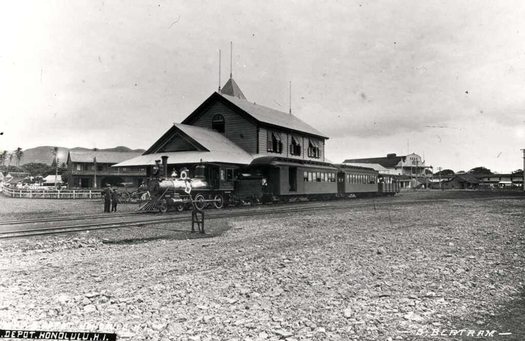
Benjamin Franklin (Frank) Dillingham formed OR&L (a narrow gauge rail,) whose economic being was founded on the belief that O‘ahu would soon host a major sugar industry.
In 1885, Dillingham embarked on a land development project west of Honolulu and, like his continental counterparts, realized that this venture would not succeed without improved transportation to the area. He also figured that a railroad needed to carry freight, as well, in order to be profitable.
The drilling of the first artesian well on the Ewa Plain by James Campbell in 1879 presented Dillingham another opportunity. He obtained 50-year leases beginning in 1887 from Campbell in Ewa.
In 1888, the legislature gave Dillingham an exclusive franchise “for construction and operation on the Island of O‘ahu a steam railroad … for the carriage of passengers and freight.”
Ultimately OR&L sublet land, partnered on several sugar operations and/or hauled cane from Ewa Plantation Company, Honolulu Sugar Company in ‘Aiea, O‘ahu Sugar in Waipahu, Waianae Sugar Company, Waialua Agriculture Company and Kahuku Plantation Company, as well as pineapples for Dole.
Likewise, OR&L hauled various stages in the pineapple harvesting/production, including the canning components, fresh pineapple to the cannery, ending up hauling the cased products to the docks.
By 1895 the rail line reached Waianae. It then rounded Kaena Point to Mokuleia, eventually extending to Kahuku. Another line was constructed through central O‘ahu to Wahiawa.
Passenger travel was an add-on opportunity that not only included train rides, they also operated a bus system. However, the hauling for the agricultural ventures was the most lucrative.
They even included a “Kodak Camera Train” (associated with the Hula Show) for Sunday trips to Haleiwa for picture-taking. During the war years, they served the military.
Just like the rail programs on the continent, the railroad owned and operated the Haleiwa Hotel and offered city folks a North Shore destination with beaches, boating, golf, tennis and hunting.
In addition, OR&L (using another of its “land” components,) got into land development. It developed Hawai‘i’s first planned suburban development and held a contest, through the newspaper, to name this new city.
The winner selected was “Pearl City” (the public also named the main street, Lehua.)
The railway owned 2,200-acres in fee simple in the peninsula. First they laid-out and constructed the improvements, then invited the public on a free ride to see the new residential community.
The marketing went so well; ultimately, lots were auctioned off to the highest bidder.
Multiple factors affected the ultimate demise of the rail operations: sugar/pineapple production fizzled in the islands; more and more people were getting automobiles for travel; a 1946 tsunami damaged tracks and the war’s end stopped military travel.
The last ride on OR&L’s train operations was on December 31, 1947, ending 58-years of steam locomotives hauling all kinds of people, freight and other around O‘ahu.
The Dillinghams were out of transportation, but were active in development, construction and dredging.
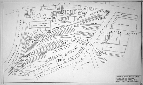
My father served as manager of the land department of OR&L (1952-1961.) When OR&L and Hawaiian Dredging and Construction Company merged to form the Dillingham Corporation, he was manager and vice president at Dillingham until 1968. As a kid, I remember going down to the old OR&L facility in Iwilei.


")


