Images of Old Hawaiʻi

  • Home
  • About
  • Categories
    • Ali’i / Chiefs / Governance
    • American Protestant Mission
    • Buildings
    • Collections
    • Economy
    • Missionaries / Churches / Religious Buildings
    • General
    • Hawaiian Traditions
    • Other Summaries
    • Mayflower Summaries
    • Mayflower Full Summaries
    • Military
    • Place Names
    • Prominent People
    • Schools
    • Sailing, Shipping & Shipwrecks
    • Voyage of the Thaddeus
  • Collections
  • Contact
  • Follow

May 20, 2023 by Peter T Young Leave a Comment

“Reclamation” Projects – Early-1900s

“Whenever in the opinion of the Board of Health any tract or parcel of land situated in the District of Honolulu, Island of Oahu, shall be deleterious to the public health in consequence of being low …”

“… and at times covered or partly covered by water, or of being situated between high and low water mark, or of being improperly drained, or incapable by reasonable expenditure of effectual drainage or for other reason in an unsanitary or dangerous condition…”

“… it shall be the duty of the Board of Health to report such fact to the Superintendent of Public Works together with a brief recommendation of the operation deemed advisable to improve such land.”  (So stated Section 1025, Revised Laws of the Territory of Hawaiʻi, in 1906.)

That year, Board of Health President, LE Pinkham, stated in a report “for the Making of Honolulu as Beautiful and Unique in Character, as nature has Endowed it in Scenery, Climate and Location:”

“Nature, situation and human circumstance fix world-wide prominence and importance on certain strategic points in commerce, navigation and defense. Human events have moved slowly, but are becoming intensely accelerated, and it would seem Honolulu is now beginning to fulfil her destiny.”

Likewise, laws in place gave the Superintendent of Public Works the right to make Improvements to property which had been condemned as insanitary by the Board of Health.

Also in 1906, the US War Department acquired more than 70-acres in the Kālia portion of Waikīkī for the establishment of a military reservation to be called Fort DeRussy.  Back then, nearly 85% of present Waikīkī was in wetland.

The Army started filling in the fishponds and wetland that covered most of the Fort site – pumping fill from the ocean continuously for nearly a year in order to build up an area on which permanent structures could be built.

Thus, the Army began the transformation of Waikīkī from wetlands to solid ground and it served as a model that others followed.

Back then, much of the makai lands from Honolulu to and including Waikīkī were characterized with lowland marshes, wetlands, coral reef flats and farming of fishponds along with some limited wetland kalo (taro) taro agriculture (and later rice.)

However, they were also characterized as, “stretched useless, unsightly, offensive swamps, perpetually breeding mosquitoes and always a menace to public health and welfare”.

The Territory saw the opportunity to drain and fill the land that “was valueless” to be “available for the growth of the business district of the city” and attain “a valuation greatly in excess of the cost of the filling and draining.”

Likewise, in areas such as Kakaʻako there were practical issues to contend with.   “Calmly wading around in muddy water up to waist, on Tuesday after noon last, a Kakaako housekeeper was busying herself hanging out the family washing to dry. Her clothes basket she towed after her on a raft.”

“None of the neighbors marveled at the strange sight for when it was wash-day at their places they had to do the same. Tied up at the front gates of many of the houses in the block were rafts, upon which the more particular members of the families ferried themselves back and forth from house to street”.  (Hawaiian Gazette, April 3, 1908)

This set into motion a number of reclamation and sanitation projects in Kakaʻako, Honolulu, Waikīkī, Lāhaina, Hilo and others.

The first efforts were concentrated at Kakaʻako – it was then more generally referred to as “Kewalo.”  The Kewalo Reclamation District included the area bounded by South Street, King Street, Ward Avenue and Ala Moana Boulevard.

This area already had a practical demonstration of dredging and filling.  In 1907, the US Army Fort Armstrong was built on fill over Kaʻākaukukui reef to protect the adjoining Honolulu Harbor.

“The plan practically takes in all the land from King street to the sea, and it will be the first step in a general reclamation scheme for the low lying lands of the city.”  (Hawaiian Star, October 24, 1911)

Kapālama Reclamation Project included approximately 60-acres of land between King Street and the main line of Oʻahu Railway and Land Company.  In addition, approximately 11-acres of land were filled from dredge material between Piers 16 and 17.

In 1925, the “practically worthless swamp lands” were converted “into property selling as high as $30,000.00 per acre.”

During this project, Sand Island and Quarantine Island were joined to the Kalihi Kai peninsula. In 1925 and 1926, a channel was dug from the Kalihi Channel into Kapālama Basin creating a true island out of “Sand Island.”

The Waikīkī Reclamation District was identified as the approximate 800-acres from King and McCully Streets to Kapahulu Street, near Campbell Avenue down to Kapiʻolani Park and Kalākaua Avenue on the makai side.  (1921-1928)

The dredge material not only filled in the Waikīkī wetlands, it was also used to fill in the McKinley High School site.

The initial planning called for the extension of the Ala Wai Canal past its present terminus and excavate along Makee Island in Kapiʻolani Park, connecting the Canal with the ocean on the Lēʻahi side of the project.  However, funds ran short and this extension was contemplated “at some later date, when funds are made available”; however, that never happened.

Eleven-and-a-half acres of Lāhaina “swamp land” (near the National Guard Armory,) drainage canals and storm sewers were part of the Lāhaina Reclamation District.  (1916-1917) Mokuhinia Pond was filled with coral rubble dredged from Lāhaina Harbor.

By Executive Order of the Territory of Hawaiʻi in 1918, the newly-filled pond was turned over to the County of Maui for use as Maluʻuluʻolele Park.

In Hilo, the Waiolama Reclamation Project included the draining and filling of approximately 40-acres in the area between the Hilo Railway tract, Wailoa River, and Baker and Front Streets.  It included diversion of the Alenaio Stream.  (1914-1919)

Generally, the consensus was the reclamation projects were successful in addressing the health concerns; in addition, they made economic sense.

As an example, in Waikīkī, before reclamation assessed values for property were at about $500 per acre and the same property reclaimed at ten cents a foot, making a total cost of $4,350 per acre.  The selling price after reclamation, $6,500 to $7,000 per acre, showed the financial benefit of the reclamation efforts.

© 2023 Hoʻokuleana LLC

Filed Under: General, Place Names, Economy Tagged With: Kapalama, Reclamation, Lahaina Wetlands, Waiolama, Ala Wai, Mokuhinia Pond, Hawaii, Waikiki, Kalihi, Kewalo, Sand Island

May 19, 2023 by Peter T Young Leave a Comment

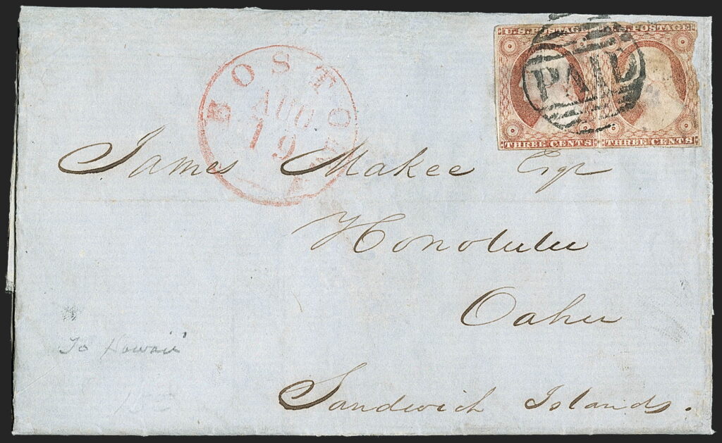
James Makee

James Makee was born at Woburn, MA, November 24, 1812. He married Catherine McNiven in New York in 1836.  He first arrived in Hawai‘i in 1843, in command of the sperm whaler Maine, having been compelled to put into this port for medical assistance.  (PCA, Sep 20, 1879)

While the Maine lay in the roadstead off Lahaina, Maui, it was learned that her master, Captain James Makee, had been attacked by the ship’s cook, brutally cut with a hatchet or cleaver, and left for dead.

This unfortunate incident, however, resulted in Captain Makee abandoning his seafaring career and he became interested in Hawai‘i and decided to locate in Honolulu, sending for Mrs. Makee, then living in Massachusetts.

Makee, then only thirty-one years of age and founder of the Makee family in Hawai‘i, remained in the islands to become a distinguished pioneer builder, first as a merchant in the whaling industry and later as a rancher and sugar planter.

As a trader in Honolulu, Captain Makee met with success in his first venture and formed the firm of Jones and Makee, ship chandlers, the partnership later becoming Makee, Anthon & Co. The company did a flourishing business and in 1850 Makee, Anthon & Co. were agents for some fifty out of seventy whaling ships in port on October 18 of that year.

The following year marked the first entry of Honolulu men into the whaling industry as ship owners, when Captain Makee, with a group of other local merchants as minority shareholders, acquired the “Chariot” and sent her into the Artic in April, 1851.

With the expansion of business in Honolulu, Captain Makee in 1853 financed the erection of the Makee & Anthon block on Queen Street, the first three-story brick building in Honolulu, materials for which were imported from Boston.

“Something New in Honolulu. A fine new Fire-Proof Store, three stories high, erecting at the corner of Kaahumanu and Queen streets, by Capt. Makee, built of brick, with a granite front, is something new in Honolulu, and consequently excites considerable attention.”

“No granite has before been used in the erection of buildings, at the islands, although fence and gate posts, and a few door-steps, have been imported from China, of a quality, however, far inferior to the Massachusetts granite now used by Capt. Makee, in the construction of his Store. This block will be of the most substantial character, and an ornament to the city.” (Polynesian, April 1, 1854)

Then, a second ship, the bark “Black Warrior,” was acquired by Makee & Anthon, and operated as a whaler for three years.

On January 23, 1856, “Kapena Ki” (Captain James Makee) purchased at auction Torbert’s plantation on Maui. He sold his Nuʻuanu residence and moved to Maui and raised his family on what he called ‘Rose Ranch’ after his wife Catherine’s favorite flower.

The extensive estate had some limited facilities for raising and milling sugar cane and was developed both as a cattle ranch and sugar plantation by Captain Makee.

He took a deep interest in the upbuilding of the property and was one of the first to import thoroughbred stock on a large scale. He also engaged in dairying and in 1858 began planting sugar cane, rehabilitating the abandoned Torbert enterprise.

Makee was one of the first to import, on a large scale, purebred stock. He also went in for dairying and his “sweet butter” found a fine market. In 1858 he began the rehabilitation of Torbert’s cane and the crop of 1861 was marketed in Honolulu.

He solved the area’s major problem – water. “Makee has built a wooden house and deep reservoir on the side of the house. The troubles of the men and women are now ended by this work, they are now truly well supplied with water. This land, in ancient times, was a barren open place, a rocky, scorched land, where water could not be gotten.”

“The water of this land in times before, was from the stumps of the banana trees (pūmaiʻa), and from the leaves of the kākonakona grass; but now there is water where moss can grow. The problem is resolved.” Nupepa Kuokoa, Iulai 7, 1866, [Maly, translator])

“Makee’s Plantation or Rose Ranch, as it is more generally termed by the proprietor and his friends, is situated on the south eastern part of the Island of Maui, in the district of Honuaula. … The estate contains about 6,500 acres, 1,200 of which are capable of producing cane.” (Pacific Commercial Advertiser, September 19, 1861 [Maly])

(From Torbert, then the decades of ownership by Makee, then Dowsett, Raymond and Baldwin, in 1963, the property was acquired by the Erdman family. The property is now known as ʻUlupalakua Ranch and it remains a cattle ranch.)

The sugar crop of 1861 was marketed in Honolulu and by 1862 the plantation had been greatly improved, according to the accounts of Rev. S. C. Damon, who visited Ulupalakua in that year.

During the Civil War Captain Makee won wide attention by a patriotic gift of two consignments of molasses, of one hundred barrels each, which he sent to San Francisco to be sold for the benefit of the Sanitary Commission at Washington, DC.

Later, a shipment of sugar and island produce was sent by Parker N. Makee, a son, as an additional contribution to the Union cause.

Throughout his residence at “Rose Ranch,” Ulupalakua, Captain Makee was noted for his hospitality, visitors from all parts of the world being entertained there.

On July 18, 1871, Colonel Zephaniah Swift Spalding married Makee’s first born daughter, Wilhelmina Harris Makee at McKee’s Rose Ranch in Ulupalakua, Maui.  In that same year, Makee’s eldest son, Parker, took over management of the West Maui Sugar Association.

In 1876, Captain Makee and Spalding purchased Ernest Krull’s cattle ranch in Kapa‘a, Kauai, intending to start a sugar plantation and mill.  After a brief stay in San Francisco (1875-1878) Spalding returned to the Islands, living on Kauai, where Makee was already operating the Makee Sugar Company and mill at Kapa‘a.

King Kalākaua and others formed a hui (partnership) to raise cane.  About the first of August, 1877, members of Hui Kawaihau moved to Kauai.  Makee had an agreement to grind their cane.

In 1876, Kapi‘olani Park was initially touted to create “a tract of land in the vicinity of Honolulu as a place of public resort,” where “agricultural and stock exhibitions, and healthful exercise, recreations and amusements” could occur, its literal purpose was far from it.

On the dedication day in 1876, King Kalākaua and James Makee (Kapiʻolani Park Association’s first president) stressed the public space, which they said was needed for a modern city to be civilized, to allow “families, children, and quiet people” to find “refreshment and recreation” in the “kindly influences of nature,” and to be a “place of innocent refreshment.”

However, when Kapiʻolani Park was first conceived, the motivation wasn’t about creating a public place.   Kapiʻolani Park began as a development project, run by the Kapiʻolani Park Association.

The association was founded with a two-fold purpose: (1) building residences for its stockholders along the ocean at Waikiki and on the slopes of Diamond Head and (2) laying out a first-class horse-racing track as a focal point of this new suburb.  They named the large island in the Park’s waterways after James Makee.

Appointed a commissioner to aid in the development of the resources of the Kingdom of Hawaii in 1877, Captain Makee in that year launched a breakwater project at Makena, Maui, developing a harbor to facilitate the shipment of sugar.

Captain Makee also owned the Waihee Plantation, Maui, of which his son, Parker, was manager. His interests in the Ulupalakua ranch were divided to members of his family in Jan., 1878.

Upon his death in Honolulu, September 16, 1879, Captain Makee was survived by his widow and eight children, Charles and Parker N Makee, Mrs ZS Spalding, Mrs MLW Kitchen, Mrs D Noonan, Mrs George Herbert, Mrs ED Tenney and Mrs FP Hastings. (lots of information here is from Orr.)

© 2023 Ho‘okuleana LLC

Filed Under: Prominent People, Economy Tagged With: James Makee, Ulupalakua, Kawaihau, Zephaniah Swift Spalding, Rose Ranch

May 18, 2023 by Peter T Young Leave a Comment

Native Americans in the American Revolution

In the 1750s, the area west of the Allegheny Mountains was a vast forest.  American Indians primarily from three nations – the Seneca, the Lenape or Delaware, and the Shawnee – inhabited the upper Ohio River Valley.

About 3,000 to 4,000 American Indians were living there.  The population of all the Indian nations in northeastern North America was about 175,000.

A few French and British traders traveled through the area.

New France had three colonies: Canada (along the St. Lawrence River), the Illinois country (the mid-Mississippi Valley), and Louisiana (New Orleans and west of the Mississippi).  There were about 70,000 colonists throughout the French settlements. Their economy was based on trade with the American Indians. It was a weak economic system, and the colonies were not self-sustaining.

To the east of the Allegheny Mountains lived more than 1 million colonists in the 13 British colonies. They had a strong economy based on farming. Their population was expanding rapidly, both through immigration and population growth.  Although they had no settlers in the Ohio River Valley in 1750, the British colonies claimed the land.

The border between French and British possessions was not well defined, and one disputed territory was the upper Ohio River valley. The French had constructed a number of forts in this region in an attempt to strengthen their claim on the territory.

The American Revolution

The relationship between native peoples and the emerging United States during the era of the American Revolution was a complicated one. From the onset of Lord Dunmore’s War in 1774 to the Treaty of Paris in 1783, Indians in North America faced a dilemma on whether they would fight, for whom they would fight, and why they would fight.

Most Native Americans initially thought that the Revolution was an isolated disagreement between white colonists and their mother country.  However, the Revolutionary War evolved into a continent-wide struggle that the Indians could not avoid.

Individual Indians joined both the Continental and British armies as regular soldiers or as scouts, guides, mariners, and diplomats.  History shows that Native Americans not only participated in the American Revolution, but also survived the long-term changes it produced.  (Merritt)

Native Americans in the Revolutionary War

Many Native American tribes fought in the Revolutionary War. The majority of these tribes fought for the British but a few fought for the Americans.  Many of these tribes tried to remain neutral in the early phase of the war but when some of them came under attack by American militia, they decided to join the British.

Other tribes joined the British in the hopes that if the British won, they would put a stop to colonial expansion in the west, as they had done with the Royal Proclamation of 1763.  Rebecca Beatrice Brooks provides a list of the various tribes who fought in the Revolutionary War:

Wabanaki Confederacy

The Wabanaki Confederacy was an alliance of five northern tribes: the Penobscot, Maliseet, Passamaquoddy, Abenaki and Micmac.  They were situated generally in Maine and New Brunswick.

Stockbridge-Mohican Tribe

The Stockbridge-Mohican, a tribe who lived in Western Massachusetts, sided with the Americans in the Revolutionary War, even though they had been long-standing allies of the British and even served in militia units during King George’s War, the French and Indian War and Pontiac’s Uprising.

Shawnee Tribe

The Shawnee, a tribe who lived in the Ohio River Valley sided with the British during the Revolutionary War.  When the Revolutionary War first broke out, most Shawnee tried to remain neutral.  American encroachment on Shawnee land persisted though and the tribe soon became divided on the issue.

Delaware Tribe

Many Delaware chiefs argued that an alliance with the Americans was an opportunity to assert the tribe’s independence from the Six Nations and to challenge the Six Nations’ claims to lands west of the Ohio. In 1778, the United States signed its first treaty, the Treaty of Fort Pitt, with the Delaware tribe. The treaty allowed American troops to pass through Delaware territory.  In addition, the Delaware agreed to sell meat, corn, horses and other supplies to the United States and allow their men to enlist in the United States army.

Miami Tribe

The Miami, a tribe in the Great Lakes region, sided with the British during the Revolutionary War.  After the British lost the war, the Miami tribe continued to fight the Americans who began pouring into the Ohio country. Between the years 1783 and 1790, the Miami tribe killed 1,500 settlers.  This sparked a war between the Americans and the Miami tribe, the Miami War, which is also known as Little Turtle’s War, from 1790-1794.  The Miami tribe were defeated. Throughout the 19th century, the Miami continued to sign more treaties and ceded more land and the tribe eventually emigrated to Kansas in 1846 and were then removed to Oklahoma in 1867.

Wyandot Tribe

The Wyandot (Huron), a tribe in the Great Lakes region, sided with the British during the Revolutionary War.  After the war, the Wyandot continued to fight the Americans who encroached on their land. There was a brief lull in the fighting from 1783-1785, and the United States, Wyandot, Delaware, Chippewa, and Ottawa tribes signed the Treaty of Fort McIntosh in 1785.  In 1843, the Wyandots were forcibly removed from their remaining land and relocated to a reservation in Kansas. After the Civil War, the Ohio Wyandot were relocated to Oklahoma.

Iroquois Confederacy

The Iroquois Confederacy, also known as the Six Nations, was an alliance of six tribes in New York and Canada: the Mohawks, Oneidas, Tuscaroras, Onondagas, Cayugas and Senecas.  The Iroquois Confederacy had been long-standing allies of the British. Yet, when the Revolutionary War broke out, the confederacy split in two when the Onondagas, Cayugas, Senecas and Mohawks sided with the British, while the Tuscarora and the Oneida sided with the Americans.

Potawami Tribe

The Potawami, a tribe in the Great Lakes region, tried to remain neutral in the Revolutionary War but eventually sided with the Americans in 1778.  The Potawami had been long-standing trading partners and military allies with the French and fought alongside them in the French and Indian War but were reluctant to get involved in another war.  They were later convinced to join the American’s side.  The Potawatomi had ceded much of their lands to the United States by the mid-19th century and the tribe split up and relocated to various distant locations, such as Texas, Kansas, Iowa and Canada, although many stayed in Wisconsin.

Catawaba Tribe

The Catawaba, a tribe with a population of a few hundred that lived in the Piedmont area along the border of South Carolina and North Carolina, sided with the Americans in 1775.  The Catawaba fought in numerous key battles in South and North Carolina. In 1782, after General Charles Cornwallis surrendered at Yorktown, the Catawaba returned home and the South Carolinians paid them for their service.  The Catawbas also received a state-recognized reservation in South Carolina as a result of their support of the Americans, which they still occupy today.

Chickasaw Tribe

The Chickasaw, a southern tribe with a population of 4,000 who lived in Mississippi, Alabama, Tennessee, Kentucky and Missouri, sided with the British during the Revolutionary War.  The Chickasaw had been trading partners and staunch allies of the British throughout the 18th century and continued their support for the British in the Revolutionary War.

Choctaw Tribe

The Choctaw, a southern tribe with a population of 15,000 who inhabited about 50 villages in a key strategic position of the lower Mississippi, were coveted by both the Americans and the British during the Revolutionary War but the tribe sided with the British.

Creek Tribe

The Creek, a southern tribe with a population of 15,000 that lived in Georgia, Alabama, Florida, and North Carolina, never officially joined the war effort, preferring instead to engage in cautious participation. The Creek tribe never engaged in significant sustained fighting during the war.

Cherokee Tribe

The Cherokee, a southern tribe with a population of about 8,500 who lived in the interior hill country of the Carolinas and Georgia, sided with the British during the Revolutionary War.  After initial successes in their attacks, the Cherokees soon witnessed four American armies from Virginia, North Carolina, South Carolina, and Georgia invade nearly all their villages during the summer and fall of 1776.

Declaration of Independence and Native Americans

In the Declaration of Independence, Thomas Jefferson clearly described the role of American Indians in the American Revolution. In addition to his other oppressive acts, King George III had,

“endeavoured to bring on the inhabitants of our frontiers, the merciless Indian Savages whose known rule of warfare, is an undistinguished destruction of all ages, sexes and conditions.”

Inscribed in the founding document of the United States, Jefferson’s words placed Indians on the wrong side of the struggle for liberty and the wrong side of history from the very beginning of the Revolution. Thus while Americans fought for their rights and freedoms, Jefferson argued that Native Americans fought against them, the vicious pawns of a tyrannical king.

Subsequent Indian Relocation (Trail of Tears)

Then, during the 1830s, there was a forced relocation of Eastern Woodlands Indians of the Southeast region of the United States (including Cherokee, Creek, Chickasaw, Choctaw, and Seminole, among other nations) to Indian Territory west of the Mississippi River – on the Trail of Tears.

Estimates based on tribal and military records suggest that approximately 100,000 indigenous people were forced from their homes during that period, which is sometimes known as the removal era, and that some 15,000 died during the journey west.

The term Trail of Tears reminds us of the collective suffering those people experienced, although it is most commonly used in reference to the removal experiences of the Southeast Indians generally and the Cherokee nation specifically.

The physical trail consisted of several overland routes and one main water route and, by passage of the Omnibus Public Lands Management Act in 2009, stretched some 5,045 miles across portions of nine states (Alabama, Arkansas, Georgia, Illinois, Kentucky, Missouri, North Carolina, Oklahoma, and Tennessee).

Click the following link to a general summary about Native Americans in the American Revolution:

Click to access Native-Americans-in-the-American-Revolution.pdf

© 2023 Hoʻokuleana LLC

Filed Under: American Revolution Tagged With: Native American, America250, American Revolution, Indian

May 17, 2023 by Peter T Young Leave a Comment

Truman Taylor

Explosive eruptions do not generally come to mind when people think of Hawai‘i’s volcanoes. Their eruptions are typically characterized by the relatively quiet outflow of very fluid lava and by sometimes spectacular lava fountains.

Hawai‘i’s volcanoes have therefore become the textbook example of nonexplosive volcanism, and the term “Hawaiian type” is used to refer to such eruptions. Eruptions at Kilauea can often be observed safely at close range.  (USGS)

The late 1780s were years of great strife on the Island of Hawai’i. Kamehameha, who later became the first king of the Hawaiian Islands, was at war with his rival Keōua. After one of several indecisive battles, probably in 1790, the balance was suddenly tipped in favor of Kamehameha when a natural disaster struck.

As a large group of Keōua’s warriors traveling with their families passed the crater of Kilauea Volcano, there was a sudden explosive eruption of searingly hot ash and gas. At least 80 and perhaps hundreds of people were killed in the deadliest historical eruption to occur in what is now the United States.  (USGS)

During 18 days in May 1924, hundreds of steam explosions from Kilauea hurled mud, debris, and hot rocks weighing as much as 8 tons as far as two-thirds of a mile from the center of Halema‘uma‘u the current crater within the larger volcanic depression (caldera) at Kilauea’s summit.

Columns of volcanic ash and dust rose more than 2 miles into the air, at times turning day into night at the town of Pahala, nearly 20 miles downwind.

Only one person was killed during this eruption, a photographer who ventured too close and was struck by falling rocks and hot mud.  (USGS)

The largest explosive event in 1924, on May 18, ejected blocks toward the southeast, including the eight-ton block, and killed Truman Taylor. (Pacific Parks)

Taylor Stearns notes in his autobiography, “[WO] Clark told me how he had brought Taylor, a clerk about twenty-seven years old from Pahala [he worked on the C. Brewer plantation], up to the volcano. Miss Bradfield, the local nurse, and her companion [Miss Peck] had been with them.”

“Taylor had borrowed Clark’s camera and tripod to take a close-up shot. [When the explosion began, Ted] Dranga and the two nurses ran to the Essex car nearby, which they had left running so as to make escape easy [those were the days of hand cranks].”

“When they reached the car the [others] wanted to start right away but Miss Bradfield said she didn’t want to leave with Taylor out there. She made them wait a minute, and then as the stones began to fall around them she decided it would be better to leave Taylor than for all to be killed.”

Per, “Ruy Finch, in the HVO journal: 10:36 a.m. With L.A. Thurston and W.O. Clark of Pahala. Large puffs of steam; rumbling, earthquake. Went to sand spit above Algae [an area of algae growing on the south-facing cliff, then known as the Italian cliff, that forms the south side of what is now known as Sand Spit] and sat down on a boulder which had been ejected at 12:30 p.m.”

“May 17. Numerous quakes and rumbling. Sent T. Dranga Jr., to get Thurston who was with Carlsmiths. A wave of increased air pressure that decidedly hurt my head, was felt at 11:09 a.m. Jumped and exclaimed, ‘Here comes a terrible one.’”

“The air pressure was felt several seconds before rocks appeared and two or three seconds before the explosion cloud cleared the rim. Started to take picture but saw rocks of great dimensions high in the air headed toward our locality.”

“Ran to cliff and slid down a wash. A rock, judging from its air appearance to have weighed over 300 lbs [135 kg] cleared the cliff and landed on 1921 lava. Left Thurston, Clark and ladies of Carlsmith party on cliff.”

“O Emerson in the afternoon reported a 10-ton rock on airplane landing-field [on Sand Spit], found while searching for possible killed or wounded soldiers. Two men were seen on rim of pit a short time before 11:09 a.m. explosion.”

“TA Dranga Sr. came across crater floor but said that Mr. Truman Taylor of Pahala, who was with him on the way up to crater, had left him 10 minutes before the explosion”

“Went back to find missing man with Clark, Dranga Jr. and Dranga Sr. Taylor was discovered with legs crushed by fallen bowlders about 125 feet from old parking place.”

“Dranga Sr. started to get car seat, to use as stretcher, when another explosion came. Dranga Jr. and I carried Taylor to road where he was put into car.”  (USGS)

“Truman A Taylor, bookkeeper at Pahala, died at 11:30 o’clock last night [May 18, 1924] at Hilo Hospital from hemorrhage and shock.  One leg had been amputated at the ankle after it had been crushed by a shower of rocks from the volcano.”

“Taylor was found shortly before noon yesterday by an unidentified man who heard screams.  He was covered by burning ash, and both legs were crushed.”

“First aid was given by Capt PK McKenzie, surgeon at Kilauea Military Camp and the injured man was rushed in Army ambulance, accompanied by Miss Molly Thomas, Hilo nurse, to Hilo Hospital.”

“Taylor was from Chicago, and had been in Pahala about two months, after a stay of three weeks in Honolulu. He wore a tag bearing the legend, ‘USA 3422044.’” (SB, May 19, 1924)

© 2023 Ho‘okuleana LLC

Filed Under: General Tagged With: 1924 Eruption, Truman Taylor, Volcano, Halemaumau

May 16, 2023 by Peter T Young Leave a Comment

Sugar, Growth Years

“The first successful sugarcane plantation was started at Kōloa, Kauai in 1835. Its first harvest in 1837 produced 2 tons of raw sugar, which sold for $200. Other pioneers, predominantly from the United States, soon began growing sugarcane on the islands of Hawaii, Maui, and Oahu.”  (HARC)

Shortly thereafter, King Kamehameha III, seeking to encourage commercial cultivation of sugar by native Hawaiians offered the “acre system,” giving “out small lots of land, from one to two acres, to individuals for the cultivation of cane.”

“When the cane is ripe, the King finds all the apparatus for manufacturing & when manufactured takes the half. Of his half one fifth is regarded as the tax due to the aupuni (government) & the remaining four fifths is his compensation for the manufacture. These cane cultivators are released from all other demands of every description on the part of chiefs.”  (Armstrong (1839;) MacLennan)

About this time, the initial signs of commercial sugar are found on Maui, in Wailuku.  In 1840, the King ordered an iron mill from the US, and it was erected by August.  Hung & Co in 1841 advertised the sale of sugar and sugar syrup from its 150-acre plantation in Wailuku. More than likely, this was sugar from the King’s Mill.  (MacLennan)

Early plantations were small and didn’t fare too well.  Soon, most would come to realize that “sugar farming and sugar milling were essentially great-scale operations.”  (Garvin)

Then, King Kamehameha III sought to expand sugar cultivation and production, as well as expand other agricultural ventures to support commercial agriculture in the Islands.  In a speech to the Legislature in 1847, the King notes:

“I recommend to your most serious consideration, to devise means to promote the agriculture of the islands, and profitable industry among all classes of their inhabitants. It is my wish that my subjects should possess lands upon a secure title; enabling them to live in abundance and comfort, and to bring up their children free from the vices that prevail in the seaports.”

“What my native subjects are greatly in want of, to become farmers, is capital with which to buy cattle, fence in the land and cultivate it properly. I recommend you to consider the best means of inducing foreigners to furnish capital for carrying on agricultural operations, that thus the exports of the country may be increased …” (King Kamehameha III Speech to the Legislature, April 28, 1847; Archives)

Hawai‘i’s economy turned toward sugar in the decades between 1860 and 1880. These twenty years were pivotal in building the plantation system. Basic features of rural factory life were established.

This was a period of rapid growth for the sugar industry, building upon the momentum triggered by the Māhele of 1848, the Kuleana Act of 1850, and the Reciprocity Treaty of 1875.  Likewise, the Civil War virtually shut down Louisiana sugar production during the 1860s, enabling Hawai‘i to compete with elevated prices for sugar.

From January 27, 1848 through March 7, 1848 King Kamehameha III participated in what we refer to as the “Great Māhele” that was a reformation of the land system in Hawaiʻi and allowed private ownership; this fundamentally changed the land tenure system to a westernized paper title system through the Māhele.

The lands were formally divided among the king and the chiefs, and the fee titles were recorded in the Māhele book.  Deeds conveying land contained the phrase “ua koe ke kuleana o na kānaka,” or “reserving the rights of all native tenants,” in continuation of the reserved tenancies which characterized the traditional Hawaiian land tenure system.  (Garavoy)

The 1850 Kuleana Act allowed “native tenants” to claim fee simple title to the lands they worked.  Those who claimed their parcel(s) successfully acquired what is known as a kuleana.

The Kuleana Act did not allow the maka‘āinana to exercise other traditional rights, such as the right to grow crops and pasture animals on unoccupied portions of the ahupua’a. The court’s interpretation of the act prevented tenants from making traditional use of commonly cultivated land.  (MacKenzie)

The growth in the size and number of sugar plantations was further fueled by the Treaty of Reciprocity – 1875 between the United States and the Kingdom of Hawai‘i that eliminated the major trade barrier to Hawai‘i’s closest and major market.

A century after Captain James Cook’s arrival in Hawaiʻi, sugar plantations started to dominate the landscape.  Hawai‘i’s economy turned toward sugar in the decades between 1860 and 1880; these twenty years were pivotal in building the plantation system.

During the Civil War boom period, the typical 1860s plantation was two hundred to three hundred acres in size, with about one hundred acres in cane, employing around one hundred workers year-round.

Hawai‘i’s government committed extensive resources to the success of sugar export. Honolulu’s merchants and financiers came to dominate sugar production. The Islands turned a corner during these decades – Hawai‘i’s dependence upon sugar began.

The fastest growth occurred on Maui, which in 1866 had twelve plantations, compared to Hawai‘i’s eight, O‘ahu’s six, and Kauai’s four.  Production on Hawai‘i Island, was just under a third of the total.

The island of Hawai’i had become the major sugar producer. Plantation statistics for the Hawaiian government in 1879 shows Hawai‘i with twenty-four plantations, Maui with thirteen, Kauai with seven, O‘ahu with seven, and Molokai with three – a total of fifty-four operations.

At the heart of this transformation was the plantation center. Unlike the commercial sugar mill, which drew on existing communities of Hawaiian workers, the plantation center represented a new clustering of population and technology.

Specifically, it was characterized by a sizable increase of foreign population, government recognition of the area as a vital economic region with distinct political needs, and by public and private investment in a shared physical infrastructure (e.g., stores, wharves, harbors) established specifically to trade with the West.

An important development in Hawai‘i’s history, the plantation center created new social institutions of dependency.  The Hawaiian government also had a significant hand in the rise of plantation centers.

The decline of whaling, collapse of the native vegetable trade, and a rapidly decreasing native population left the government with huge expenditures and little source of income.

In response, it applied public funds and assets toward the sugar trade in hopes of increasing Hawai‘i’s wealth. The Board of Immigration was established in 1866 to recruit workers for plantations. (MacLennan)

Five plantation centers changed the surrounding landscape and altered nearby Hawaiian communities. Plantations in Līhu‘e, Wailuku, Makawao, Hilo and Kohala brought an invasion of agricultural practices, technologies and repeopled the land with foreigners (from China, Portugal and Japan) and Hawaiians from other islands.

Characteristics of the five developing plantation centers separate them from the smaller sugar ventures of the period.  Plantation centers comprised several separate sugar mills and fields of different owners. Schools, stores, and worker villages sprang

up around these centers, serving the plantations.

By 1880 there were several other very new centers in Ka‘ū and Honoka’a on Hawai‘i, Lahaina on Maui, Princeville on Kauai, and several scattered plantations on O‘ahu. (MacLennan)

© 2023 Ho‘okuleana LLC

Filed Under: General, Buildings, Place Names, Economy Tagged With: Hawaii, Plantation Center

  • « Previous Page
  • 1
  • …
  • 228
  • 229
  • 230
  • 231
  • 232
  • …
  • 679
  • Next Page »

Images of Old Hawaiʻi

People, places, and events in Hawaiʻi’s past come alive through text and media in “Images of Old Hawaiʻi.” These posts are informal historic summaries presented for personal, non-commercial, and educational purposes.

Info@Hookuleana.com

Connect with Us

  • Email
  • Facebook
  • LinkedIn
  • Twitter
  • YouTube

Recent Posts

  • Boondocks
  • About 250 Years Ago … Battle of Kings Mountain
  • Cow Laws
  • Palea and the Pinnace
  • Yick Lung
  • Early Days at Kamehameha Schools
  • ʻĪmaikalani

Categories

  • Ali'i / Chiefs / Governance
  • Buildings
  • Missionaries / Churches / Religious Buildings
  • Hawaiian Traditions
  • Military
  • Place Names
  • Prominent People
  • Schools
  • Sailing, Shipping & Shipwrecks
  • Economy
  • Voyage of the Thaddeus
  • Mayflower Summaries
  • American Revolution
  • General

Tags

Albatross Al Capone Ane Keohokalole Archibald Campbell Bernice Pauahi Bishop Charles Reed Bishop Downtown Honolulu Eruption Founder's Day George Patton Great Wall of Kuakini Green Sea Turtle Hawaii Hawaii Island Hermes Hilo Holoikauaua Honolulu Isaac Davis James Robinson Kamae Kamaeokalani Kameeiamoku Kamehameha Schools Lalani Village Lava Flow Lelia Byrd Liberty Ship Liliuokalani Mao Math Mauna Loa Midway Monk Seal Northwestern Hawaiian Islands Oahu Papahanaumokuakea Marine National Monument Pearl Pualani Mossman Quartette Thomas Jaggar Volcano Waikiki Wake Wisdom

Hoʻokuleana LLC

Hoʻokuleana LLC is a Planning and Consulting firm assisting property owners with Land Use Planning efforts, including Environmental Review, Entitlement Process, Permitting, Community Outreach, etc. We are uniquely positioned to assist you in a variety of needs.

Info@Hookuleana.com

Copyright © 2012-2024 Peter T Young, Hoʻokuleana LLC

Loading Comments...