Thanksgiving is a major holiday celebrated in the United States, with origins dating back centuries to Colonial times.
The faith of celebrating a harvest of plenty was a dramatic event in early Colonial America, since food supplies were far from dependable. Years of massive starvation were as common as times of plenty.
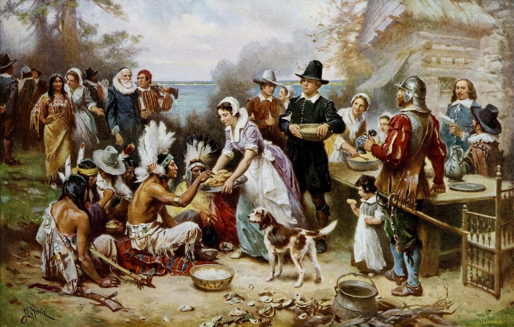
Although Native Americans were known to have harvest celebrations for centuries, if not millennia, before arrival of Europeans, the quintessence of Thanksgiving in all regions was a joint celebration of colonists and indigenous peoples, sharing the bounty of autumn and their common survival.
The site and date of origin of Thanksgiving are matters of great dispute, with regional claims being made by widely disparate locations in North America. The chief claims are: Saint Augustine, Florida – 1565; Baffin Island, Canada – 1578; Jamestown, Virginia – 1619 and Plymouth, Massachusetts – 1621.
Na-Huihui-O-Makaliʻi, “Cluster of Little Eyes” (Makaliʻi) (a faint group of blue-white stars) marks the shoulder of the Taurus (Bull) constellation. Though small and dipper-shaped, it is not the Little Dipper. (Makaliʻi is also known as the Pleiades; its common name is the Seven Sisters.)
Traditionally, the rising of Makaliʻi at sunset following the new moon (about the middle of October) marked the beginning of a four-month Makahiki season in ancient Hawaiʻi (a sign of the change of the season to winter.)
In Hawaiʻi, the Makahiki is a form of the “first fruits” festivals common to many cultures throughout the world. It is similar in timing and purpose to Thanksgiving, Oktoberfest and other harvest celebrations.
Something similar was observed throughout Polynesia, but it was in pre-contact Hawaiʻi that the festival. Makahiki was celebrated during a designated period of time following the harvesting season.
As the year’s harvest was gathered, tributes in the form of goods and produce were given to the chiefs from November through December.
It’s not clear when the first western Thanksgiving feast was held in Hawaiʻi, but from all apparent possibilities, the first recorded one took place in Honolulu and was held among the families of the American missionaries from New England.
According to the reported entry in Lowell Smith’s journal on December 6, 1838: “This day has been observed by us missionaries and people of Honolulu as a day of Thanksgiving and praise to Almighty God. Something new for this nation.”
“The people turned out pretty well and they dined in small groups and in a few instances in large groups. We missionaries all dined at Dr. Judd’s and supped at Brother Bingham’s. … An interesting day; seemed like old times – Thanksgiving in the United States.”
A January 1, 1841 reference by Laura Fish Judd, Sketches of Life in Honolulu states: “There were twenty-five adults and thirty-two children of the station in Honolulu, and a proposition to unite in appropriate religious exercises and a Thanksgiving dinner, met with unanimous approval. …”
“Each lady was to furnish such dishes as suited her taste and convenience, while the table arrangements were the portion of one individual. … At three o’clock we had donned our best apparel, and sat down at the long table to enjoy a double feast.”
The first Thanksgiving Proclamation in Hawaiʻi appears to have been issued on November 23, 1849, and set the 31st day of December as a date of Thanksgiving. This appeared in ‘The Friend’ on December 1, 1849.
The following, under the signature of King Kamehameha III, named the 31st of December as a day of public thanks. The Thanksgiving Proclamation of 1849 read, in part:
“In accordance with the laws of this Kingdom, and the excellent usage of Christian Nations, it has pleased his Majesty, in council, to appoint the Thirty-first day of December, next, as a day of public thanksgiving to God, for His unnumbered mercies and blessings to this nation; and …”
“… people of every class are respectfully requested to assemble in their several houses of worship on that day, to render united praise to the Father of nations, and to implore His favor in time to come, upon all who dwell upon these shores, as individuals, as families, and as a nation.” (Signed at the Palace. Honolulu, November, 23, 1849.)
“It will be seen by Royal Proclamation that Monday, the 31st of December has been appointed by His Majesty in Council as a day of Thanksgiving. We are glad to see this time-honored custom introduced into this Kingdom.”
As noted in an 1850 edition of The Friend, “Among the many good imports into this Kingdom, we rejoice that on the last day of 1849 a National Thanksgiving made its appearance. His Majesty, Kamehameha, could not have made an appointment that would call up in the minds of Americans in his dominions, more pleasing and time hallowed associations.”
“Thanksgiving is a season as fondly cherished and observed by the descendants of the Pilgrims, as Christmas is by people of the ‘old countries.’ To be sure, Thanksgiving on the 31st of December when that occurs on Monday, rather shocks our ideas of the festival, which we have always been accustomed to celebrate on Thursday, and that Thursday ordinarily the last of November …”
“… but not supposing it possible for the King to err, we would merely express the wish that his ministers will consult their almanac next year before making the appointment. This is however, of minor importance — we come to matters of graver moment. …”
“Under the general direction of the Rev. Mr. Armstrong, Minister of Public Instruction, all the Protestant Schools in Honolulu were assembled at ten o’clock at the stone church [Kawaiaha‘o].”
“It was a pleasant spectacle, on a most charming Monday morning to witness group after group of neatly dressed children wending their way to the place of gathering, conducted by their respective teachers.”
“Soon after the audience was seated, His Majesty, the Queen, the Premier, the Minister of Foreign Relations, and others, took their seats upon the platform.” [A program of singing, chants and public addresses was described in the record.] (The Friend, January 4, 1850)
The celebratory day of Thanksgiving changed over time. On December 26, 1941 President Roosevelt signed into law a bill making the date of Thanksgiving a matter of federal law, fixing the day as the fourth Thursday of November.
Here is a link to information on the First Thanksgiving:
Click to access First-Thanksgiving.pdf
Happy Thanksgiving!!!