Images of Old Hawaiʻi

  • Home
  • About
  • Categories
    • Ali’i / Chiefs / Governance
    • American Protestant Mission
    • Buildings
    • Collections
    • Economy
    • Missionaries / Churches / Religious Buildings
    • General
    • Hawaiian Traditions
    • Other Summaries
    • Mayflower Summaries
    • Mayflower Full Summaries
    • Military
    • Place Names
    • Prominent People
    • Schools
    • Sailing, Shipping & Shipwrecks
    • Voyage of the Thaddeus
  • Collections
  • Contact
  • Follow
You are here: Home / Categories

November 16, 2021 by Peter T Young Leave a Comment

Bison

Bison had survived for 2 million years until humans arrived.  In the 1500s, an estimated 30-60 million of these shaggy brown beasts roamed widely across the interior of Canada, the United States, and far Northern Mexico.  (BBC, Ogden)

Scientists and historians estimate that there were at least 30 million bison roaming the country before Euro-American settlement of the West. (NPS, McAfee)

Then, Buffalo Started to Disappear

The 1849 discovery of gold in California initiated a relentless stream of prospectors and other settlers through the Platte River Valley. Heavy subsistence hunting along the trail divided the existing bison herd into separate Southern and Northern herds.  (PERC)

In just a few short years, cattle replaced the American bison as the leading, cloven-hoofed, grass-eating mammal on the Great Plains. In 1850, millions of bison ranged the grasslands and were the main natural resource for the region’s American Indians.

By 1850, subsistence hunting and habitat destruction had removed all of the bison east of the Mississippi, leaving perhaps 15 million on the Great Plains. (PERC)

“Buffaloes travel in a straight line. When they were moving and encountered a herd of Texas cattle they invariably bored right through the herd, turning neither to right nor left. It was just the same if but one or a dozen buffaloes were on the move – they walked straight through.” (James H. Cook as told to Eli S. Ricker, May 23, 1907)

In 1868, the steel rails of the transcontinental railroad created a barrier that bison did not like to cross.  (Nebraska Studies)  Construction of the Union Pacific through the valley made the division of the herd permanent, as the wary bison simply evacuated the railroad corridor.  (PERC)

Prior to 1870, hunting pressure on bison west of the Mississippi was modest. Plains Indians effectively managed bison herds as common property, engaging in subsistence hunting and in harvesting the vaunted “buffalo robe” (used for carriage throws and heavy fur coats) for sale to eastern markets.

Though the robes were valuable, they could be harvested only in the winter and only from bison living in high northern latitudes—an arduous and risky undertaking at best. Hence, the western bison continued to thrive.  (PERC)

Then in 1870, a process was developed that so bison hides could be commercially tanned into soft, flexible leather. This happened at the same time there was a high demand for leather to make the belts that powered machines in the Industrial Revolution.

There were huge markets in England, France, and Germany. Bison hunters poured onto the Great Plains.  (Nebraska Studies)

Bison hides from which the hair had been removed (called flint hides) were superb for making the soles of boots and industrial belts.  European armies and factories were a huge market, and within months of the tanning innovation, orders for bison hides poured into America.  (PERC)

Most people tend to think the hides were valued because they made fine robes or coats. But that wasn’t really the case.  During the 1870s,  industrial growth skyrocketed in the US and Europe, and demand for leather industrial belts expanded.

Cowhide tended to stretch and factory workers would have to occasionally stop production to tighten belts by cutting out sections.

The epidermal layer in buffalo hide is up to three times thicker than that of cattle and has wider spaced sub-dermal collagen fibers making it more durable and flexible, and better suited for use in industrial conveyor and drive belts.  (Bell, Dodge City Daily Globe)

The price that hunters received for a flint hide jumped from $0 in 1870 to about $2.80 in 1871, and stayed in the range of roughly $2.30 – $2.80 for the next 15 years.

A good hunter could bring several thousand hides to market in a season, but could expect pay of only about $50 per month as a ranch hand. It is little surprise then, that many hundreds of men quickly entered the business of hunting bison. (PERC)

“Commercial hunting by North American aboriginals and Euroamericans for meat and hides was the primary cause of the decline. Other contributing factors included subsistence hunting, indiscriminate slaughter for sport, and transection of the plains by railroads.” (Isenberg)

“Environmental factors such as regional drought, introduced bovine diseases, and competition from domestic livestock and domestic and wild horses also played a role.”

“Additionally, because bison provided sustenance for North American aboriginals and commodities for their barter economy, the elimination of bison was viewed by Euroamericans as an efficient method to force the aboriginal population onto reserves and allow for continued western development.”  (Isenberg)

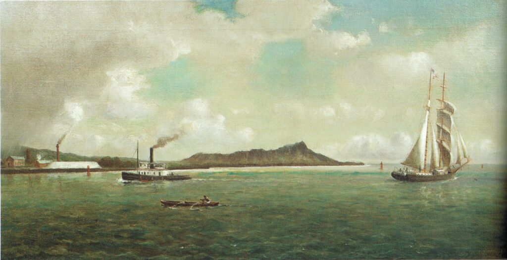
In the Islands at this Time – ‘A City in a Grove’

“When the whalers began to frequent (Honolulu Harbor) place in numbers, a town soon sprung up, and by the year 1820, Honolulu contained some six or seven thousand inhabitants.  To-day its population is reckoned at 17,000, a larger number than the capital of the important British Colony of New Zealand could recently boast.”

“The First view of Honolulu, on approaching it from the sea, has been variously described by visitors, some of whom have expressed great disappointment, whilst others have gone into raptures over the scene.

“Unless, however, from exaggerated descriptions the traveler has been led to expect something extremely wonderful and unusual, I do not understand how anyone can fail to be charmed with the view of Honolulu and its surrounding scenery as seen from the deck of an approaching vessel, especially after many days’ confinement on shipboard, with nothing but the waste of waters around him.”

“It is true that the hills of Oahu have not the same luxurious clothing of vegetation that is common in many of the island groups of the Southern Pacific. It is true also that the town has no characteristic buildings of a striking nature to arrest attention.”

“Nevertheless, Honolulu is a prettier place to look at from the sea than nineteen out of twenty port tropics or elsewhere. It has rightly been called ‘a city in a grove.’”

Click the following link for more on Bison and the Islands at the time:

https://imagesofoldhawaii.com/wp-content/uploads/Bison.pdf

© 2021 Hoʻokuleana LLC

Filed Under: General, Place Names, Economy Tagged With: Bison, Buffalo

November 15, 2021 by Peter T Young 1 Comment

Meeting House

The origin of the town meeting form of government can be traced to meetinghouses of the colonies.  Early English settlers came to America for religious freedom from the Church of England. They set up a society that was free of the ornate, rigid traditions of the Anglo-Catholic church.

The central focus of every New England town was the meetinghouse.  These structures were usually the largest building in the town. They were used both for religious worship, and for conducting town business.  Taxes supported these structures.

They were always very simple buildings, with no statues, decorations, or stained glass. Not even a cross hung on the wall.

The practice of supporting the church with tax money continued until about 1820, when individual states passed laws separating church and state. Until that time, it was common (except in Rhode Island) to support the dominant church – referred to as the “standing order” – by taxing the citizens.

In fact, in the early years a town was not granted a charter until it had built a meetinghouse and hired a minister. Rhode Island did not support the church with taxes because it was founded by the Baptists who were expelled from the Massachusetts Bay Colony for refusing to pay the church tax.

These structures have evolved over the centuries. Most that are still standing have been renovated several times to meet the needs of their owners and the styles of the times.

In the early 1800s, people wanted ‘modern’ churches that had one entrance on a short end of the building, a long isle to a pulpit on the other short end, and slip pews instead of box pews.  At this time it was also common to build steeples over the entrances, either incorporated into the building, or as part of an entrance porch that was added to the building’s end.

Many a typical white New England church started out as a colonial meetinghouse. An interesting variation to the “make a church” type of renovation took place in several towns when the separation of church and state took place.

In these cases, the thrifty New Englanders complied with the law by building a floor at the balcony level, and using the first floor for town business, and the second floor for church. Many meetinghouses thus have a floor at what used to be the balcony level.  (ColonialMeetingHouses-com)

Plymouth Meeting House

The first structure the Pilgrims built at Plymouth was a fort (it also served as the Pilgrims’ meeting house).  As noted by Bradford,

“On ye 15. of Desemr [1620]: they wayed anchor to goe to ye place they had discovered, & came within 2. Leagues of it, but were faine to bear up againe; but ye 16. day ye winde came faire, and they arrived safe in this harbor.”

“And after wards tooke better view of ye place, and resolved wher to pitch their dwelling; and ye 25. day begane to erecte ye first house for comone use to receive them and their goods.”

According to John Cuckson’s A Brief History of the First Church in Plymouth, the first meetings of the congregation in Plymouth were held in a common house built ca. 1621 and located on the south side of Leyden Street, the first street laid out in Plymouth, which runs between the harbor and what is now known as Town Square. This building consisted of a twenty-foot-square form. (NPS)

Unfortunately, that initial structure was lost to fire, “… ye 14th of January [1621] the house which they had made for a general randevoze [rendezvous/meeting house] by casualty fell afire, and some were fain to retire aboard for shelter.”  (Bradford)

Worship services were then held in a fort, built ca. 1621, on what is now known as Old Burial Hill. The fort was located directly behind the current First Parish Church.

According to Isaak de Rasiers, who visited Plymouth in 1627, the building consisted of “a large square house with a flat roof made of sawn planks set on oak beams, upon the top of which they have six cannon…. . The lower part they use for their church, where they preach on Sundays and the usual holidays.” (NPS)

Later, a separate meetinghouse was built in either 1637 or 1648 – accounts differ.

Since the Mayflower Pilgrims’ first Meetinghouse was built at the top of Leyden Street in Plymouth, MA in 1621, a place of spiritual ministry has continued to this day. Presently, the First Parish Unitarian Universalist Church of Plymouth worships at this centerpiece of the Plymouth, MA cultural district.

The Mayflower Meetinghouse (formerly the National Pilgrim Memorial Meetinghouse) is the fifth spiritual structure built on this location.  The first meetinghouse was built on common land on the north side of Town Square, at a different location from the subsequent four meetinghouses. (GSMD)

When the General Society of Mayflower Descendants (GSMD) became aware that the congregation was having trouble with the increasing maintenance and restoration of the building, it approached the congregation about donating the Meetinghouse to GSMD as a place to fulfill its educational mission.

To save the building they love, the First Parish Church congregation has agreed to donate it to GSMD upon the condition that funds be put in place to permanently maintain it, and that they be allowed to continue scheduling their services there.

The General Society of Mayflower Descendants and First Parish Church signed a Joint Venture Agreement, which led to the Charitable Trust, during Congress 2017.

Along with the Meetinghouse, GSMD will be given all the church records from modern times back to 1620, written by William Bradford, William Brewster, Robert Cushman, and many others.

Click the following link to a general summary about the Meeting House:

https://imagesofoldhawaii.com/wp-content/uploads/Meeting-House.pdf

© 2021 Hoʻokuleana LLC

Filed Under: Mayflower Summaries Tagged With: Mayflower, Meeting House, Pilgrims

November 14, 2021 by Peter T Young Leave a Comment

James Hay Wodehouse

James Hay Wodehouse was born on April 23, 1824. He was the second son of Charles Nourse Wodehouse (Archdeacon of Norwich) and Lady Dulcibella Jane Hay. He married Annette Fanny Massey, daughter of William Massey, on January 19, 1861.

Wodehouse was private secretary to George Grey (Governor of New Zealand) in 1851; on November 5, 1860, it was announced, “The Queen has been graciously pleased to appoint Major James Hay Wodehouse to be her Majesty’s consul in the Society or Leeward Islands in the Pacific Ocean.”  (London Daily News, November 24, 1860)

On June 21, 1866, “The Queen has been graciously pleased to appoint James Hay Wodehouse, Esq … to be Her Majesty’s Commissioner and Consul-General in the Sandwich Islands.”  (British Bulletins, 1866)

A retired British Army Major, Wodehouse took up his duties and thereafter worked diligently to protect British interests during a long career.  (Andrade)  “Minister Wodehouse represented the British Governmental the Hawaiian court for over twenty-five years with great credit.”   (San Francisco Call, August 11, 1895)

These were tumultuous times in the Islands.  Through several monarchs, the issue of independence / annexation and takeover by others were part of the ongoing discussions.

“About the end of 1867, Queen Emma, in a conversation with British Commissioner JH Wodehouse, assured him ‘that with a few exceptions, all the natives were opposed to annexation.’”  (Daws)

“Many times, Kamehameha V stated his firm resolve to maintain the independence of his kingdom, and there is no good reason to doubt the sincerity of these declarations. British Commissioner Wodehouse reported a conversation with the king in which the latter expressed ‘his determination to resist any project for the annexation of his Islands to the United States.’”  (Daws)

On January 17, 1893, Queen Lili`uokalani yielded her authority to the US government.  In 1895, an abortive attempt by Hawaiian royalists to restore Queen Liliʻuokalani to power resulted in the Queen’s arrest.

Convicted of having knowledge of a royalist plot, “at two o’clock on the afternoon of the 27th of February I was again called into court, and sentence passed upon me … a fine of $5,000, and imprisonment at hard labor for five years.” (Queen Liliʻuokalani)  The sentence was commuted to imprisonment in an upstairs apartment in ʻIolani Palace.

“(Wodehouse) was strongly opposed to the revolution, and made himself obnoxious to the Provisional Government, who came to regard the British legation as the chief center of royalist intrigue.”    (San Francisco Call, August 11, 1895)

The British Government, having recognized the Hawaiian Republic, recalled Wodehouse and appointed Mr Hawes British commissioner and consul general.  Major Wodehouse, on his departure, neglected to pay an official farewell to the Dole Government, and proposed to take leave of the ex-Queen, imprisoned in the palace.  (Appletons’, 1895)

“Previous to Mr Wodehouse’s departure from Honolulu he requested a parting interview with ex-Queen Liliʻuokalani, but the request received a positive refusal. The reason assigned was that Mr Wodehouse still held an official character of which he could not divest himself, so as to render his visit to the former Queen one merely of friendship.”  (San Francisco Call, August 11, 1895)

“(A)n open letter of Mrs Wodehouse to the ex-Queen had been returned to the writer because it was addressed to ‘Her Majesty.’ The denial of intercourse in the case of the British Minister is an exception to a very considerable degree of the freedom usually allowed to Mrs Dominis in seeing her friends.  (San Francisco Call, August 11, 1895)

Wodehouse had other reasons for desiring to be relieved of his duties at this time. He had been in Hawaiʻi for 15-years without any leave, was not in good health and wished to return to England to spend his last years.  The British government accordingly granted him leave to return to England.  (Andrade)  Wodehouse died in England on July 13, 1911.

Here’s a little Wodehouse side note:  A malfunctioning chronometer put the British sailing ship Dunnottar Castle off course and onto the reef at Kure atoll.  Seven of the crew members, including its Chief Officer, took one of the surviving boats and sailed, for 52 days, to Kauaʻi. Upon being informed of the tragedy, the British Commissioner in Honolulu organized a rescue mission. (HawaiianAtolls)

Wodehouse decided to send a ship for the remaining crew.  Suspecting that the British might use the occasion to annex the island, the Hawaiian Government shared the expedition expenses and instructed Commissioner James Boyd to take formal possession of Kure.  On September 20, 1886 Boyd took possession of the island, then-called Mokupāpapa, for the Hawaiian government.  (PMNM)

The rescue mission came back to Honolulu with the same amount of people it had sailed out with. No survivors were found on the atoll, except for two fox terriers and a retriever. All of the survivors had been picked up earlier by a passing vessel and were on route to Chile.  (HawaiianAtolls)

Here’s another side note, relating to one of Wodehouse’s sons, ‘Hay.’  On July 30, 1889, Robert William Wilcox led a rebellion to restore the rights of the monarchy, two years after the Bayonet Constitution of 1887 left King Kalākaua a mere figurehead.

“The day was won, they say, by a base ball (catcher,) who threw dynamite bombs into the bungalow that formed the headquarters of the insurgents and brought them to terms quicker than rifle or cannon shot.”

“Bombs were made, but it was found that there were no guns to fire them. It was a long throw, and in their dilemma the King’s guards secured the services of Haywood (Wodehouse,) (catcher) of the Honolulu Base Ball Club.”

“(Wodehouse) took up his position in the Coney Island building, just across a narrow lane, and overlooking the bungalow. No attack was expected from that quarter, and there was nothing to disturb the bomb thrower. (Wodehouse) stood for a moment with a bomb in his hand as though he were in the box waiting for a batsman. He had to throw over a house to reach the bungalow, which he could not see.”

“The first bomb went sailing over the wall, made a down curve and struck the side of the bungalow about a foot from the roof … The bomb had reached them and hurt a number of the insurgents.  (Wodehouse) coolly picked out another bomb. Then he took a step back, made a half turn and sent it whizzing. It landed on the roof … He threw one more bomb and Wilcox came out and surrendered.”    (The Sporting Life, October 16, 1889)

Here’s one more … The unveiling of the Captain Cook monument in Kealakekua Bay took place on November 14, 1874.  Credit for it is given to Princess Likelike (sister of King Kalākaua and Queen Liliʻuokalani, and mother of Princess Kaʻiulani (who sold the land for $1 on January 26, 1877 to be held in trust for the monument in memory of Captain Cook)) and British Commissioner Wodehouse.

“The erection of a suitable and durable monument to the memory of Captain James Cook has been often proposed and more than once attempted, but has now been happily accomplished under the direction of Mr Wodehouse, the British Commissioner, with the cooperation of Captain Cator of HMS ship Scout, who kindly conveyed the architect and his men and materials to the spot in Kealakekua Bay, where the circumnavigator fell, and where now, nearly a century later, a fitting monument is at last dedicated to his memory.”

“It is a plain obelisk, standing on a square base, the whole being twenty-seven feet in height, and constructed throughout of a concrete composed of carefully screened pebbles and cement, similar to tie material of which the fine public buildings in this city are built. It stands on an artificially leveled platform of lava only a few feet distant from and above the highwater mark, and fifteen or twenty yards from the shore or lava slab on which the great seaman stood when struck down.”

“The site is thus the most suitable that could have been chosen, and is the gift of Princess Likelike, wife of Hon. AS Cleghorn. The expense of the erection is partly borne by subscribers in England…”  (Hawaiian Gazette, November 25, 1874)

© 2021 Hoʻokuleana LLC

Filed Under: Prominent People Tagged With: Captain Cook, Robert Wilcox, Mokupapapa, Kealakekua, Dunnottar Castle, Kure, James Hay Wodehouse, Hawaii, Queen Liliuokalani, King Kalakaua, Iolani Palace

November 13, 2021 by Peter T Young 1 Comment

Kanakea Pond

In the Waiākea area called Keaukaha (‘passing current’) at Hilo on the Island of Hawaiʻi a legend refers to a hole called Kaluakoko beneath the water.

A man and a woman lived nearby, and later a second woman came to live with them.

The new wife became jealous of the first, and convinced her to go net fishing one day when the husband was fishing, though the husband had forbidden it because it would affect his fishing.

As she caught shrimp at the edge of a large hole, the second wife pushed her into the hole and covered the entrance with a rock, killing her. Blood spread through the sea foam and the fisherman, followed its trail in his canoe, moved the stone, and saw what had happened.

He confronted the second wife, who lied, and then beat her to death. According to the story, the hole has been referred to as Kaluakoko (‘the Hole of Blood.’) (Cultural Surveys)

Here, Kanakea (‘wide stream’) pond is located. A freshwater subterranean spring rises from a large sinkhole and feeds cold water into the bay at a former fishpond.

Due to apparent remnant of a seaward rock wall at the narrowest point of the channel to the ocean, it is believed to be a loko kuapā.  A cobble field, submerged except during low tide, is in a linear pattern, suggesting they may have been in the formation of the pond wall.  (However, the cobbles may have simple accumulated there by currents or tsunami.)

“There are plenty of ducks in the ponds and streams, at a short distance from the sea, and several large ponds or lakes literally swarm with fish, principally of the mullet kind.”

“The fish in these ponds belong to the king and chiefs, and are tabued from the common people. Along the stone walls which partly encircle these ponds, we saw a number of small huts, where the persons reside who have the care of the fish, and are obliged frequently to feed them with a small kind of muscle, which they procure in the sands round the bay.”  (Ellis, 1823)

“On the nights of high tides every keeper slept by the mākāhā of which he had charge. It was the custom to build small watch houses from which to guard the fish from being stolen at high tide, or from being killed by pigs and dogs; when the tides receded the fish would return to the middle of the pond, out of reach of thieves.”

“On these nights, the keeper would dip his foot into the water at the mākāhā and if the sea pressed in like a stream and felt warm, then he knew that the sluice would be full of fish.”  (Kamakau; Maly)

Railway tracks crossed the pond from about 1916 until 1946 (when they were destroyed by a tsunami;) remnants of the railroad trestle are still visible within and above the surface of the pond.  (Hawaiʻi County)

The pond’s modern name is ‘Ice Pond’ (due to the cold spring-fed waters.)  It is brackish (that word comes from the Middle Dutch root ‘brak’ (‘salty.’))

The adjoining small bay consists of white sand and coral rubble; between 1925 and 1930, coral material dredged from Hilo harbor was deposited on the western side.

The small bay is now referred to as ‘Reed’s Bay.’  It is named after William H Reed. Born in 1814 Belfast, Ireland, Reed was a businessman. He created Reed’s Landing, which he used to moor boats carrying lumber for one of his businesses.  (Hawaiʻi County)

Reed arrived in the Islands in the 1840s and set up a contracting concern specializing in the construction of wharfs, landings, bridges and roads.  Other interests included ranching, trading and retailing.  (Clark)

Across Hilo Bay, Reed also bought an island in 1861, originally known as ‘Koloiki’ (‘little crawling,’) once surrounded by the Wailuku River and Waikapu Stream.

Reed married Jane Stobie Shipman on July 8, 1868 (she was a widow, previously married to William Cornelius Shipman, a missionary assigned to Waiʻōhinu in the district of Kaʻū.  Shipman died in 1861, leaving Jane with her three children, William Herbert, Oliver Taylor and Margaret Clarissa.)

Jane was born in Scotland. At an early age she came to the US with her parents, lived in Quincy, Illinois, and was educated to be a teacher; and in 1853 was married to Reverend Shipman.  (The Friend, December, 1902)

Following his death, Jane moved to Hilo, with her three children and maintained the family by keeping a boarding school until 1868 (when she was married to Reed.)  (The Friend, December, 1902)

William Reed died on November 11, 1880 with no children of his own; Jane inherited the Reed land holdings.  (In 1881, Reed’s stepson William Herbert Shipman and two partners (Captain J. E. Eldarts and Samuel M Damon) purchased the entire ahupuaʻa of Keaʻau, about 70,000-acres from the King Lunalilo estate.)

© 2021 Hoʻokuleana LLC


Filed Under: Hawaiian Traditions, Place Names Tagged With: Waiakea, Reed's Island, Keaukaha, William Reed, Reed's Bay, Kanakea Pond, Hawaii, Hawaii Island, Hilo

November 12, 2021 by Peter T Young Leave a Comment

Na Keiki Kapu a Kekaulike

Poʻolua is literally broken down as Poʻo (head) and lua (two) and refers to a child who has two fathers (the child is sired by other than the husband, but he is accepted by both the husband and the sire.)

A child said to be poʻolua, “that is, a child of two fathers, was considered a great honor by chiefs of that period.” (Luomala)

King Kekaulike (1700-1736) was the 23rd King (Mo‘i) of Maui and founder of Maui’s last ruling dynasty.  He was descended from Pi‘ilani (‘ascent to heaven’) the Great.

Maui-Loa was the first independent sovereign of Maui. Twenty generations of independent monarchs ruled in Maui from the Prince Maui-Loa until the accession of Pi‘ilani the Great who is perhaps the most renowned monarch of the island Kingdom of Maui.

The kings of Maui consolidated their strength, built up their armies and created a nation strong enough to threaten at times even the might of the powerful kings of Hawai‘i.

King Kekaulike and his children built an empire that enjoyed levels of power and prestige greater than any other royal family up until that point.

In a footnote on page 261 of Fornander’s Account of the Polynesian Race Vol. II, he states:

“Though every Hawaiian genealogy in my possession invariably states that Kame‘eiamoku and Kamanawa were the twin children of Keawepoepoe and his wife Kanoena, yet all the older legends which refer to these two chiefs call them the sons of Kekaulike. “Na keiki kapu a Kekaulike.”

In addition, Kamakau referenced, “Ka-meʻe-ia-moku and Kamanawa, the twins of the burning tabu of Ke-kau-like.”

It was the custom in Hawai‘i during the 18th and 19th centuries to have young chiefs be hānai (adopted) by and grow up under the protection of an important relative, sometimes even one who lived on another island.

Kamanawa and Kame‘eiamoku were sent to live with their uncle during their childhood years. This uncle was Kalani‘ōpu‘u, the high chief of the Island of Hawai‘i in 1779, when Captain Cook arrived at Kealakekua Bay in Kona, Hawai‘i.

Kamehameha was also raised in the court of Kalani‘ōpu‘u, along with two of the sons of Kalani‘ōpu‘u, Kīwala‘ō and Keōua. (Kelly)

At the time of ‘contact’ (Captain Cook’s arrival (1778,)) the Hawaiian Islands were divided into four kingdoms: (1) the island of Hawaiʻi under the rule of Kalaniʻōpuʻu, who also had possession of the Hāna district of east Maui; (2) Maui (except the Hāna district,) Molokai, Lānaʻi and Kahoʻolawe, ruled by Kahekili; (3) Oʻahu, under the rule of Kahahana; and (4) Kauai and Niʻihau, Kamakahelei was ruler.

“At that time Kahekili was plotting for the downfall of Kahahana and the seizure of Oʻahu and Molokai, and the queen of Kauai was disposed to assist him in these enterprises. The occupation of the Hana district of Maui by the kings of Hawaiʻi had been the cause of many stubborn conflicts between the chivalry of the two islands …”

“… and when Captain Cook first landed on Hawaiʻi he found the king of that island absent on another warlike expedition to Maui, intent upon avenging his defeat of two years before, when his famous brigade of eight hundred nobles was hewn in pieces.” (Kalākaua)

Then, in 1782, Kamehameha started his conquest to rule the Islands. After a struggle of more than ten years, in 1791, Kamehameha succeeded in securing the supreme authority over the island of Hawaiʻi.

After conquering that Island, he moved on to defeat the armies in Maui Nui and concluded his wars on Oʻahu at the Battle of Nuʻuanu in 1795. After failed attempts at conquering Kauai, he negotiated peace with Kaumualiʻi and the Island chain was under his control (1810.)

In getting there, Kamehameha appointed Keʻeaumoku, Keaweaheulu, Kameʻeiamoku and Kamanawa (the four Kona Uncles) to be his secret advisors (hoa kuka malu) and counselors (hoaʻahaʻolelo) in ruling the island. They alone were consulted about what would be for the good or the ill of the country. (Kamakau)

Kahekili’s rule stretched for almost thirty years. He became known for his extreme measures whether it was making sure his people were obeying the kapu and the gods, or by destroying his enemies.

He ruled on Maui before he fell ill and returned to Waikīkī, until his death in 1793 at the age of eighty-seven.  As with all ali‘i, Kahekili’s bones were carried away and hidden – thought to be in North Kohala.

After Kahekili died, Fornander had an interesting perspective related to the relationships of the parties.  Fornander notes, “Kameʻeiamoku and his twin-brother Kamanawa secretly took Kahekili’s body away and hid it in one of the caves at Kaloko in North Kona, Hawaii.” 

“Kameʻeiamoku and Kamanawa were the children of Kekaulike of Maui, and thus half-brothers of Kahekili.”  The twins (Kameʻeiamoku and Kamanawa) were Chiefs from the Kohala and North Kona districts and were uncles of Kamehameha and his counselors in the wars to unite the islands.

“If this fact is truly accredited to those two Hawaiian chieftains, and, although happening in comparatively modern times, I have never heard or seen it disputed, it will, in consideration of the ancient customs, go far to justify the current opinion of that time, shared alike by chiefs and commoners, that Kame‘eiamoku and Kamanawa were the children of Kekaulike of Maui, and thus half-brothers of Kahekili.”

“This relationship receives further confirmation from the native legends when they relate that, on learning the birth of Kamehameha, Kahekili sent these two sons of his father Kekaulike to Hawaiʻi to be and act as ‘Kahus’ to Kamehameha.”  (Fornander)

“In no other way can the otherwise singular fact be explained that two of Kamehameha’s oldest and most prominent and trusted councilor chiefs, during a time of what may be called suspended hostilities …”

“… should have repaired from Hawaii to Oahu for the purpose of securing and safely hiding (Huna-kele) the bones of Kamehameha’s political rival; nor the otherwise equally inexplicable fact that they should have been permitted by Kalanikūpule, Kahekili’s son and successor, to carry their design into effect.”  (Fornander)

“Under the social system of the old regime, and of time-hallowed custom, Kamehameha would have had no power to prevent those chiefs from executing their pious errand, and Kalanikūpule would have had no motive to mistrust their honesty when resigning to them his father’s remains …”

“… and a breach of trust on their part would have consigned them to an infamy of which Hawaiian history had no precedent, and so deep, that the Hawaiian language would not have had a word detestable enough wherewith to express it.”  (Fornander)

“He was the reputed and accepted son of Keōua, the half-brother of Kalaniʻōpuʻu, although it was believed by many that his real father was Kahekili, mōʻi of Maui. But, however this may have been, he was of royal blood, and was destined to become not only the king of Hawaiʻi, but the conqueror and sovereign of the group. This chief was Kamehameha.”  (Kalākaua)

Kamehameha, through the assistance of the Kona “Uncles” (Keʻeaumoku, Keaweaheulu, Kameʻeiamoku & Kamanawa (the latter two ended up on Hawai‘i’s coat of arms;)) succeeded, after a struggle of more than ten years, in securing to himself the supreme authority over that island (and later, the entire Hawaiian Islands chain.)

The twins were later neighbors.

Kamanawa is reported to have been living at Kiholo at the time of the death of Kalani‘ōpu‘u in 1782, and Kame‘eiamoku at Ka‘upulehu (originally Ka‘ulu-pulehu, the roasted breadfruit), the adjacent ahupua‘a to the south of Pu‘uwa‘awa‘a. (Kelly)

The lives of the twin chiefs of Kekaha, Kamanawa of Kiholo, and Kame‘eiamoku of Ka‘upulehu, are closely bound with the history of the Hawaiian Islands during the period of the rise of Kamehameha I, as the ali‘i nui (high chief) of the Islands.

Presumably, whoever had control over the leeward ports of the Island of Hawai‘i would play an important part in the history of the Islands during this early historical period.

The Kona-Kohala coast had more favorable harbors for the visits of western-sailing ships than the windward (Hilo-Puna-Ka‘u) coast. Because of this, the Kona-Kohala chiefs had greater access to trade items from the foreign ships than the windward chiefs.

As it was, that role fell to Kamehameha, Kamanawa, Kame‘eiamoku, Ke‘eaumoku, and a few others.  (Kelly)

FYI: Kamehameha has also been referred to as poʻolua (shared, two-headed) son of Keōua and Kahekili by his mother Kekuʻiapoiwa.  (VanDyke)

Kameʻeiamoku (on his deathbed) said to Kamehameha, “I have something to tell you: Kahekili was your father, you were not Keōua’s son. Here are the tokens that you are the son of Kahekili.”  (Kamakau)

Kamehameha responded, “Strange that you should live all this time and only when dying tell me that I am Kahekili’s son! Had you told me this before, my brothers need not have died; they could have ruled Maui while I ruled Hawaii.”    (Kamakau)

Kameʻeiamoku answered, “That is not a good thought; had they lived there would have been constant warfare between you, but with you alone as ruler the country is at peace.”    (Kamakau)

© 2021 Hoʻokuleana LLC

Filed Under: Ali'i / Chiefs / Governance Tagged With: Royal Twins, Kameeiamoku, Kamanawa, Kekaulike

  • « Previous Page
  • 1
  • …
  • 292
  • 293
  • 294
  • 295
  • 296
  • …
  • 661
  • Next Page »

Images of Old Hawaiʻi

People, places, and events in Hawaiʻi’s past come alive through text and media in “Images of Old Hawaiʻi.” These posts are informal historic summaries presented for personal, non-commercial, and educational purposes.

Info@Hookuleana.com

Connect with Us

  • Email
  • Facebook
  • LinkedIn
  • Twitter
  • YouTube

Recent Posts

  • About 250 Years Ago … ‘Give Me Liberty, Or Give Me Death’
  • About 250 Years Ago … Stamp Act
  • Telling Time
  • Arterials
  • Place Names
  • Hawaiʻi Statehood Address – Aloha ke Akua
  • Eleanora and Fair American

Categories

  • General
  • Ali'i / Chiefs / Governance
  • Buildings
  • Missionaries / Churches / Religious Buildings
  • Hawaiian Traditions
  • Military
  • Place Names
  • Prominent People
  • Schools
  • Sailing, Shipping & Shipwrecks
  • Economy
  • Voyage of the Thaddeus
  • Mayflower Summaries
  • American Revolution

Tags

Albatross Al Capone Ane Keohokalole Archibald Campbell Bernice Pauahi Bishop Charles Reed Bishop Downtown Honolulu Eruption Founder's Day George Patton Great Wall of Kuakini Green Sea Turtle Hawaii Hawaii Island Hermes Hilo Holoikauaua Honolulu Isaac Davis James Robinson Kamae Kamaeokalani Kameeiamoku Kamehameha Schools Lalani Village Lava Flow Lelia Byrd Liberty Ship Liliuokalani Mao Math Mauna Loa Midway Monk Seal Northwestern Hawaiian Islands Oahu Papahanaumokuakea Marine National Monument Pearl Pualani Mossman Quartette Thomas Jaggar Volcano Waikiki Wake Wisdom

Hoʻokuleana LLC

Hoʻokuleana LLC is a Planning and Consulting firm assisting property owners with Land Use Planning efforts, including Environmental Review, Entitlement Process, Permitting, Community Outreach, etc. We are uniquely positioned to assist you in a variety of needs.

Info@Hookuleana.com

Copyright © 2012-2024 Peter T Young, Hoʻokuleana LLC


Loading Comments...