Images of Old Hawaiʻi

  • Home
  • About
  • Categories
    • Ali’i / Chiefs / Governance
    • American Protestant Mission
    • Buildings
    • Collections
    • Economy
    • Missionaries / Churches / Religious Buildings
    • General
    • Hawaiian Traditions
    • Other Summaries
    • Mayflower Summaries
    • Mayflower Full Summaries
    • Military
    • Place Names
    • Prominent People
    • Schools
    • Sailing, Shipping & Shipwrecks
    • Voyage of the Thaddeus
  • Collections
  • Contact
  • Follow
You are here: Home / Categories

April 3, 2023 by Peter T Young Leave a Comment

Kāne‘ohe Yacht Club

The Kāne‘ohe Yacht Club was organized on October 28, 1924, with the original Club site on the western side of Kāne‘ohe Bay. 
 
 
Opening ceremonies at the present site were held on December 17, 1955.  Reportedly, Kāne‘ohe Yacht Club is the oldest Yacht Club in Hawai‘i, in terms of continuous service.
 
When we were kids, KYC and the Bay were our back yard.
 
Our house was about a block away.  An entrance gate to the club was at the end of the street of the old neighborhood.
 
A significant milestone and rite of passage in life was turning 10-years of age – it was then that you could go down to the Yacht Club on your own, without adult supervision.
 
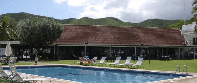
Lots of the club is pretty much the same.  (However, to add more mooring spaces, there is a new parallel dock on the right side of the image below (where the El Toros are sailing.)
 
The place was kid-friendly and accommodating to young adults.  Back in the day, the Long House was available for periodic teen dances (hundreds of us packed the place.)  (Does anybody else remember the Vaqueros?)
 
We’d keep the Boston Whaler down there, and on a moment’s notice could run down and hoist it into the water for running around the Bay.
 
Back then, the clover-leaf opening in the reefs on the Marine Base side of the Club was the “ski lanes.” 
 
Two rafts were anchored across each other to keep you high and dry, while others in the group skied around the loop.  (It’s now used for mooring of larger boats.)
 
The Whaler also took us to all other points of interest on the Bay, camping at Coral Island, Kapapa and Chinaman’s Hat (Mokoli‘i;) fishing and diving across the bay; and just general cruising around.
 
In addition to the ski/cruising outboard boat, we first had the Mokuone, then Na Ali‘i Kai, then Lanakila fishing boats and regularly entered the Club’s fishing tournaments.
 
In addition to mooring and dry storage areas, the Club has two tennis courts, a swimming pool and a kid-sized wading pool.
 
And, it has a bar.  As a kid, that was some mysterious place that you were forbidden to enter.  We’d gaze in to see what was up.
 
I swear, looking into the bar, now, it looks like the same people sitting there sipping their cocktails – they must be the kids of the adults we used to look at.
 
There are swimming and sailing classes for kids and young adults offered throughout the year and plenty to do for the adults, too.
 
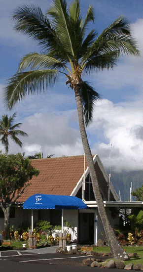
The first image shows the Kāne‘ohe Yacht Club as we knew it as kids, in a pre-1966 postcard noted in “The History of Kaneohe Yacht Club” book.  (This is the way I remember the club from small-kid times.)
 
© 2023 Ho‘okuleana LLC

Filed Under: General Tagged With: Kaneohe, Kaneohe Yacht Club, Hawaii, Kaneohe Bay

April 2, 2023 by Peter T Young Leave a Comment

Holoua

In historical times, two tsunamis occurred during the first week of April. The first of these occurred on April 2, 1868; it resulted from the great earthquake that took place that day near Pahala.

Based on the extent and type of damage, the 1868 earthquake is estimated to have had a magnitude of about 8.0. Reports indicate that 46 people were killed and several entire Hawaiian villages were destroyed by the tsunami generated from the earthquake. (USGS)

Destruction caused by the 1868 great Ka‘ū earthquake included the Wai‘ōhinu in the Ka‘ū District of Hawai‘i Island. With a magnitude estimated at 7.9, the earthquake is the largest in Hawai‘i’s recorded history. (USGS)

“There were twelve shocks counted during the night. -most of them easy, one however rocked the bed considerably At four oclock that afternoon there was such an awful rocking and heaving of the earth as we never felt before.”

“Indeed there was a series of shocks following each other in quick succession the third of which drove us from the house.”

“After a cessation of only one or two minutes the fourth came. in which violent undulations, rotary, and all most all other motions were combined or followed each other in quick succession. “

“At one moment the surface of the earth seemed to move like the surface of the ocean and the large trees to sway hither and thither like ships masts in a storm. The few stone buildings in the place were ruined.”

“The chimneys of cook and dwelling houses were thrown down. Clocks, mirrors and crockery, not firmly secured, were generally thrown down and broken. Cellar walls and underpinning were much damaged.”

“Stone walls were generally prostrated, even the foundation stones being generally removed from their original position. and it was not easy to tell in which direction from the wall the larger portion of the stones had fallen.”

“The best chimney stacks of the Hilo Sugar Mills were thrown down while some of the old cracked chimneys supposed all most ready to fall were little affected. The shocks were considerably more severe here than they were at the crater of Kilauea thirty miles from here, but less severe than they were in Kau from Kapapala to Kahuku.”

“Then slight jars were felt almost constantly for a few minutes after which the earth commenced rocking again fearfully. This continued but a short time and was followed by a tidal wave.”  (Sarah Lyman; USGS)

A letter “by the School Inspector-General [Abraham Fornander] gives a detailed account of the volcanic phenomenon on Hawaii” in the April 29, 1868 issue of the Hawaiian Gazette.

Fornander notes, “I have just been told an incident that occurred in Ninole, during the inundation of that place.  At the time of the shock on Thursday, a man named Holoua, and his wife, ran out of the house and started for the hills above, but remembering the money he had in the house, the man left his wife and returned to bring it away.”

“Just as he had entered the bouse the sea broke on the shore, and, enveloping the building, first washed it several yards inland, and then, as the wave receded, swept It off to sea, with him in it.”

“Being a powerful man, and one of the most expert swimmers in that region, he succeeded in wrenching off a board or a rafter, and with this as a papa hee-nalu, (surf board), be boldly struck out for the shore, and landed safely with the return wave.”

“When we consider the prodigious height of the breaker on which he rode to the shore, (50, perhaps 60, feet), the feat seems almost Incredible, were it not that be is now alive to attest it, as well as the people on the hillside who saw him.” (Fornander in Hawaiian Gazette, April 29, 1868)

Artist William CP Cathcart of Honolulu made a painting of the event and calls what Holoua did, ”the greatest aquatic feat of its kind in the history of the world”.

“Not many would quarrel with him that [Holoua], is the granddaddy of all surfriders.  [Holoua] happens to be riding the crest of a 50 to 60 foot tidal wave, using a house rafter for a surfboard.”

“Says Artist Cathcart: ‘[Holoua] prevailed, the undefeated super-champion of surfers …’ Mr Cathcart suggests the [Holoua’s] deed should be commemorated with a large bronze statue, suitably placed.  The deed itself, he says, merits ‘a tribute that would immortalize the prestige of Hawaii through centuries.’”

“Just to show what the water was like that day, the old Commercial Advertiser reported that four villages and 100 persons perished in the waves.” (Honolulu Advertiser, March 10, 1957)

An obituary for Holoua’s grandson, Joseph Kanuu Holoua, notes that the story “has been passed from generation to generation of Holouas. Aa Holoua used a house rafter for a surfboard and safely [rode] a 50 to 60-foot tidal wave to shore.” (Honolulu Advertiser, March 12, 1961)

The April 2 great Ka‘ū earthquake was part of a larger volcanic crisis that unfolded over 16 days. On March 27, an eruption quietly began in Moku‘āweoweo, the caldera at the summit of Mauna Loa.

Seismic activity increased through the day, and by the afternoon of March 28, a magnitude-7.0 earthquake occurred in Ka‘ū, which caused extensive damage from its own very strong to violent shaking.

During the following four days, nearly continuous ground shaking was reported in Ka‘ū and South Kona. Earthquakes continued at rates of 50 to 300 per day, including a magnitude-6.0 each day, leading up to April 2.

Then, the great Ka‘ū earthquake, 15 times stronger than the magnitude-7.0 foreshock, occurred at 4 pm. A severe aftershock occurred on April 4, and aftershocks of decreasing magnitudes continued for decades.

The great Ka‘ū earthquake unlocked Mauna Loa’s Southwest Rift Zone, and on April 7, 1868, an eruptive fissure opened low on the mountain, just above today’s Highway 11 and east of Hawaiian Ocean View Estates. (USGS) (The other April tsunami was April 1, 1946.)

© 2023 Ho‘okuleana LLC

Filed Under: General, Prominent People Tagged With: Tsunami, Surfing, Earthquake, Holoua

March 31, 2023 by Peter T Young Leave a Comment

King of Handcuffs

Erik Weisz was born on March 24, 1874 in Budapest, Hungary. His family soon emigrated to the United States. His name was altered to Ehrich Weiss after his family emigrated from Hungary to Wisconsin when he was 4 years old.

He had several brothers and a sister. When he was only five or six years old he started doing card tricks and in his teens was performing magic for money.  He called himself Ehrich the Prince of Air when he was nine years old.

When he was 13, Weisz moved with his father to New York City, taking on odd jobs and living in a boarding house before the rest of the family joined them.

He won several competitive medals as a member of the Pastime Athletic Club track team in New York. Weiss worked hard to build up his physical stamina.

In 1894, Ehrich decided to start his career as a magician and changed his name to Harry Houdini.  The name pays homage to Jean Eugene Robert-Houdin, the French performer widely considered the father of modern magic.

Adding the “i” followed tradition as well, as this was a common way that magicians invoked the name of the famous 18th century Italian conjurer Pinetti. “Harry,” on the other hand, was merely a pleasantly American twist on “Ehrie,” his boyhood nickname. (PBS)

He married Wilhelmina Beatrice “Bess” Rahner in 1894, and she became his constant companion, ardent supporter and talented co-star in many of his acts. (Pacific Coast Air Museum)

Ferenc Dezső Weisz, Houdini’s younger brother, had performed with his sibling earlier in his career. As the “King of Handcuffs” gained fame, he and his brother, then known as Hardeen, continued to work on illusions, maintaining the belief that the pair were vicious rivals to keep the interest in both of their acts.

As Hardeen once stated, “We made no secret of the fact that we were brothers… but we did keep secret not only the fact that we were good friends but that Harry had set me up in business!” (Ripley’s)

He made a name for himself escaping from handcuffs, securely chained boxes thrown into rivers, straight jackets (while suspended by his ankles), and any number of other incredible situations.

Some may not be aware that another of the passions of Houdini’s life was aviation.  He asked Orville and Wilbur Wright and Glenn Curtiss to sell him a plane but they wouldn’t.

Later in 1909 Houdini went to an air show in Berlin and approached the winner of one of the races. He offered to buy the plane and pay the pilot to teach him to fly. (Pacific Coast Air Museum)

Houdini’s airplane was a Voisin, named after its French designer/builder. It looked more like a box kite than a modern airplane and with good reason. Its design was based on principles worked out years before by an Australian named Lawrence Hargrave who had built the first controllable box kite. Houdini’s Voisin had a pusher engine and performed quite well for its time.

In 1910 the Australians made Houdini an offer he couldn’t refuse: they would pay him generously if he would spend six weeks there flying in public shows. He, his wife, and his ground crew packed up the Voisin, boarded an ocean liner, and set up operations at a place called Digger’s Rest, Victoria, near Melbourne.

Houdini went on the record books as the first person ever to fly an airplane in Australia … powered and sustained and controlled.  Houdini was presented with a trophy for his achievement and was lauded in the press. (Pacific Coast Air Museum)

Houdini flying over Australia:

It was on his way back from Australia that Houdini made a connection to Hawai‘i.  “Houdini, the handcuff king, was a through passenger on the steamship Manuka, fresh from Australia.”

“He was asked by local theatrical managers if he would stop off here, and he relied he would be glad to a series of entertainments – at $1500 per week.”

“The managers gasped and fell dead, metaphorically.  Mr Houdini, it is needless to say, passed on and will give exhibitions in Canada.” (Advertiser, May 26, 1910)

Fortunately John Cox of WildAboutHoudini-com was able to acquire an unpublished image of Houdini and Bess with lei, noted as “Honolulu 1910”.

© 2023 Ho‘okuleana LLC

Filed Under: Prominent People Tagged With: Hawaii, Harry Houdini, Erik Weisz, Ehrich Weiss

March 30, 2023 by Peter T Young Leave a Comment

Declaratory Act

The Stamp Act was passed by Parliament in 1765; effectively, it required the colonists to pay a tax, represented by a stamp.

Included under the act were bonds, licenses, certificates, and other official documents as well as more mundane items such as plain parchment and playing cards.  It imposed a tax on all papers and official documents in the American colonies, though not in England.

It was a direct tax imposed by the British government without the approval of the colonial legislatures and was payable in hard-to-obtain British sterling, rather than colonial currency.

Further, those accused of violating the Stamp Act could be prosecuted in Vice-Admiralty Courts, which had no juries and could be held anywhere in the British Empire. (Gilder-Lehrman Institute of American History)

The colonists had recently been hit with three major taxes: the Sugar Act (1764), which levied new duties on imports of textiles, wines, coffee and sugar; the Currency Act (1764), which caused a major decline in the value of the paper money used by colonists; and the Quartering Act (1765), which required colonists to provide food and lodging to British troops under certain circumstances.

With the passing of the Stamp Act, the colonists’ grumbling finally became an articulated response to what they saw as the mother country’s attempt to undermine their economic strength and independence.

The first legislative protest against the Stamp Act came from Virginia.  On May 30, 1765, the House of Burgesses adopted four resolutions, submitted by Patrick Henry.  On the 8th of June, Massachusetts issued the call for the Stamp Act congress.

By November 1, the date on which the Stamp Act was to go into effect, the resolutions of assemblies and public meetings, and the intimidation and violence of the ‘Sons of Liberty’ and others, had made the execution of the act impossible, even if stamps could have been had.

A circular letter from Conway to the governors, dated October 24, urging them to do their utmost to maintain law and order, and authorizing them to call upon the military and naval commanders for assistance, if necessary, was unavailing.

At the opening of Parliament, December 17, papers relating to affairs in America were submitted.

Numerous petitions were also presented setting forth the losses which the Stamp Act had inflicted upon British trade.

A resolution declaratory of the right of Parliament to tax the colonies, submitted February 3, was adopted by large majorities.

On the 6th the Lords, by a vote of 59 to 54, resolved in favor of executing the Stamp Act; but a similar proposition in the Commons was rejected by a vote of more than two to one.

On the 12th the King announced himself favorable to modification of the act; while the examination of Franklin before the House of Commons further strengthened the argument for repeal.

The repeal bill and the declaratory bill passed the Commons March 4, and on the 7th the declaratory bill passed the Lords.

The proposition to repeal the Stamp Act, however, encountered strong opposition in the Lords, where 33 members entered a protest against it at the second reading, and 28 at the third; but on the 17th the bill passed, and the next day both acts received the royal assent.

Parliament appeased the unruly colonists by repealing the Stamp Act.  However, the repeal of the Stamp Act did not mean that Great Britain was surrendering any control over its colonies.

The Declaratory Act, passed by Parliament on the same day the Stamp Act was repealed; members of Parliament were upset that colonists had challenged their authority and they asserted complete authority to make laws binding on the American colonies “in all cases whatsoever” and stated that the British Parliament’s taxing authority was the same in America as in Great Britain. (LOC)

The act particularly illustrated British insensitivity to the political maturity that had developed in the American provinces during the 18th century, partly in response to Parliament’s unwritten policy of salutary neglect toward the colonies during the first half of the century. (Select Charters Illustrative of American History)

Click the following link to a general summary about the Declaratory Act:

Click to access Declaratory-Act.pdf

© 2023 Hoʻokuleana LLC

Filed Under: American Revolution Tagged With: Declaratory Act, America250, American Revolution, Stamp Act

March 29, 2023 by Peter T Young Leave a Comment

Hui Panalāʻau

Part of the equatorial “Line Islands” and “Pacific Remote Islands,” Baker, Howland and Jarvis Islands were first formed as fringing reefs around islands formed by volcanoes (approximately 120-75 million years ago). As the volcanoes subsided, the coral reefs grew upward forming low coral islands.

Howland Island lies 1,650 sea miles to the southwest of Honolulu, and 48 miles north of the equator. It and Baker Island, which lies about 35 miles to the south and a little east, are located northwest of the Phoenix group, and are 1,000 miles west of Jarvis.

There is evidence to suggest that Howland Island was the site of prehistoric settlement, probably in the form of a single community utilizing several adjacent islands. Archaeological sites have been discovered on Manra and Orona, which suggest two distinct groups of settlers, one from eastern Polynesia and one from Micronesia.

US whaling ships first sighted the islands in 1822.  The islands are habitat for birds.  Alfred G Benson and Charles H Judd took formal possession of the islands (as well as Jarvis Island) in 1857 in the name of the American Guano Company of New York (consistent with the Guano Act of August 18, 1856.)

The Guano Act stated that “when any citizen of the United States discovers a guano deposit on any island, rock, or key, not within the lawful jurisdiction of any other government, and takes peaceable possession thereof, and occupies the same island, rock, or key, it appertains to the United States.”

“The Peruvian Government has monopolized the supply of Guano throughout the United States … on account of said monopoly, the Farmers of this country have hithertofore been obliged to pay for said article about $50 a ton … it is the duty of the American Government to assert its sovereignty over any and all barren and uninhabitable guano islands of the ocean which have been or hereafter may be discovered by citizens of the United States …” (American Guano Company Prospectus, 1856)

“This Company own(s) an island in the Pacific Ocean, covered with a deposit of more than two hundred million tons of ammoniated guano and have dispatched a ship, agent, and men, to maintain possession thereof.” (American Guano Company Prospectus, 1856)

Rich guano deposits were mined throughout the later part of the 19th century, however, the guano business gradually disappeared, just before the turn of the century.  Thoughts of and activities on the islands disappeared.

Then, in mid-1930s, the US Bureau of Air Commerce (later known as Department of Commerce) was looking for sites along the air route between Australia and California to support trans-Pacific flight operations (non-stop, trans-Pacific flying was not yet possible, so islands were looked to as potential sites for the construction of intermediate landing areas.)

The United States reasserted its claim to the islands in 1935 (followed by President Franklin D Roosevelt issuing Executive Order 7368 to clarify American sovereignty and jurisdiction over the islands, on May 13, 1936.)

To affirm a claim, international law required non-military occupation of all neutral islands for at least one year.  An American colony was established.

The US Bureau of Air Commerce believed that native Hawaiian men would be best suited for the role as colonizers and they turned to Kamehameha Schools graduates to fill the role.

“They looked for someone that had some Hawaiian background. And that’s why they came to Kamehameha Schools to see if they can get someone from the school to participate because of our descendance as part-Hawaiians, that we would be used to the South Pacific or wherever.”  (James Carroll, colonist)

School administration selected the participants based on various academic, citizenship and ROTC-related criteria, as well as their meeting specified requirements for the job: “The boys have to be grown-up, know how to fish in the native manner, swim excellently and handle a boat, that they be disciplined, friendly, and unattached, that they could stand the rigors of a South Seas existence.”

On March 30, 1935, the United States Coast Guard Cutter Itasca departed in secrecy from Honolulu Harbor with 6 young Hawaiians aboard (all recent graduates of Kamehameha Schools) and 12 furloughed army personnel, whose purpose was to occupy the barren islands of Baker, Howland and Jarvis for 3-months.

“Once you get there, you wish you never got there. You know, you’re on this island just all by yourself and it’s, you know, nothing there at all. Just birds, birds, millions and millions of birds. And you just don’t know what to do with yourself, you know. It takes you a while to adjust to that, but once you adjust to it, it’s fine.”  (Elvin Mattson, colonist)

The American colonists were landed from the Itasca, April 3, 1935. They have built a lighthouse, substantial dwellings and attempt to grow various plants.

Cruises by Coast Guard cutters made provisioning trips approximately every three months to refit and rotate the colonists stationed on each island. Soon plans were put into place to build airfields on the islands and permanent structures were built.

In addition to their basic duties of collecting meteorological data for the government, the colonists kept busy by building and improving their camps, clearing land, growing vegetables, attempting reforestation and collecting scientific data for the Bernice Pauahi Bishop Museum.

In their free time, they would fish, dive, swim, surf/bodysurf, lift weights, box, play football, hunt rats, experiment with bird recipes, play music, sing and find other ways of occupying themselves.

Tragedy struck twice: Carl Kahalewai, a graduate of McKinley High School, died of appendicitis while he was being rushed home for an emergency operation; and on December 8, 1941, when the islands of Howland and Baker were bombed and shelled by the Japanese, Joseph Keliʻihananui and Richard “Dickie” Whaley were killed.

Howland Island played a role in the tragic disappearance of Amelia Earhart and Fred J Noonan during their around-the-world flight in 1937. They left Lae, New Guinea and headed for Howland Island; the Itasca was at Howland Island to guide Earhart to the island once she arrived in the vicinity – they didn’t arrive and were never seen again.  A lighthouse (later a day beacon) was built on Howland Island in Earhart’s honor.

The colonists were removed, following Japanese attacks on the islands in 1942. US military personnel occupied the islands during World War II. The islands have remained unoccupied since that time, but they are visited annually by US Fish and Wildlife personnel because the islands are a National Wildlife Refuge and later part of the Pacific Remote Islands Marine National Monument.

During the 7 years of colonization (1936-1942,) more than 130 young men participated in the project, the majority of whom were Hawaiian; none of the islands were ever used for commercial aviation, but the islands eventually served military purposes.  (Pan American Airways used Canton (Kanton) Island for its trans-Pacific flight flying boat operations.)

As early as 1939, members of previous trips formed a club to “perpetuate the fellowship of Hawaiian youths who have served as colonists on American equatorial islands.” Initially they were called the “Hui Kupu ʻĀina,” which suggests the idea of sprouting, growing and increasing land.

By 1946 the group’s name had changed to “Hui Panalāʻau,” which has been variously translated as “club of settlers of the southern islands,” “holders of the land society” and “society of colonists.” (Lots of information and images here are from Bishop Museum.)  

© 2023 Hoʻokuleana LLC

Filed Under: Prominent People, Economy Tagged With: Hui Kupu Aina, Baker, Itasca, Pacific Remote Islands, Guano Act, Hawaii, Hui Panalaau, Kamehameha Schools, Amelia Earhart, Jarvis, Howland, Line Islands

  • « Previous Page
  • 1
  • …
  • 214
  • 215
  • 216
  • 217
  • 218
  • …
  • 671
  • Next Page »

Images of Old Hawaiʻi

People, places, and events in Hawaiʻi’s past come alive through text and media in “Images of Old Hawaiʻi.” These posts are informal historic summaries presented for personal, non-commercial, and educational purposes.

Info@Hookuleana.com

Connect with Us

  • Email
  • Facebook
  • LinkedIn
  • Twitter
  • YouTube

Recent Posts

  • About 250 Years Ago … Stars and Stripes, the US Flag (also US Army Birthday)
  • Kaname Yonamine
  • Moon Nights
  • Kamehameha Day
  • The Hawaiian Club
  • Linekona School
  • Kalihi Air Crash

Categories

  • General
  • Ali'i / Chiefs / Governance
  • Buildings
  • Missionaries / Churches / Religious Buildings
  • Hawaiian Traditions
  • Military
  • Place Names
  • Prominent People
  • Schools
  • Sailing, Shipping & Shipwrecks
  • Economy
  • Voyage of the Thaddeus
  • Mayflower Summaries
  • American Revolution

Tags

Albatross Al Capone Ane Keohokalole Archibald Campbell Bernice Pauahi Bishop Charles Reed Bishop Downtown Honolulu Eruption Founder's Day George Patton Great Wall of Kuakini Green Sea Turtle Hawaii Hawaii Island Hermes Hilo Holoikauaua Honolulu Isaac Davis James Robinson Kamae Kamaeokalani Kameeiamoku Kamehameha Schools Lalani Village Lava Flow Lelia Byrd Liberty Ship Liliuokalani Mao Math Mauna Loa Midway Monk Seal Northwestern Hawaiian Islands Oahu Papahanaumokuakea Marine National Monument Pearl Pualani Mossman Quartette Thomas Jaggar Volcano Waikiki Wake Wisdom

Hoʻokuleana LLC

Hoʻokuleana LLC is a Planning and Consulting firm assisting property owners with Land Use Planning efforts, including Environmental Review, Entitlement Process, Permitting, Community Outreach, etc. We are uniquely positioned to assist you in a variety of needs.

Info@Hookuleana.com

Copyright © 2012-2024 Peter T Young, Hoʻokuleana LLC

Loading Comments...