Images of Old Hawaiʻi

  • Home
  • About
  • Categories
    • Ali’i / Chiefs / Governance
    • American Protestant Mission
    • Buildings
    • Collections
    • Economy
    • Missionaries / Churches / Religious Buildings
    • General
    • Hawaiian Traditions
    • Other Summaries
    • Mayflower Summaries
    • Mayflower Full Summaries
    • Military
    • Place Names
    • Prominent People
    • Schools
    • Sailing, Shipping & Shipwrecks
    • Voyage of the Thaddeus
  • Collections
  • Contact
  • Follow

March 18, 2022 by Peter T Young 2 Comments

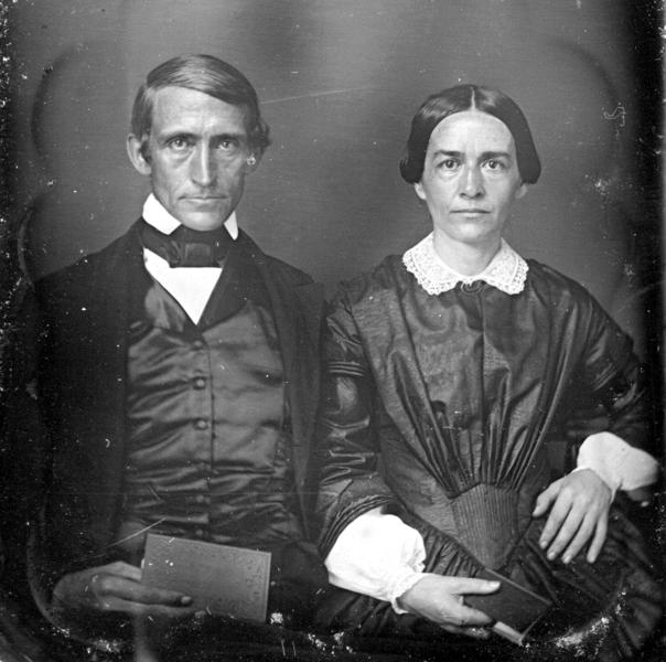
Daniel Dole

Daniel Dole was born in Bloomfield (now Skowhegan,) Maine, September 9, 1808. He graduated from Bowdoin College in 1836 and Bangor Theological Seminary in 1839, and then married Emily Hoyt Ballard (1807-1844,) October 2, 1840 in Gardiner, Maine.

The education of their children was a concern of missionaries. There were two major dilemmas, (1) there were a limited number of missionary children and (2) existing schools (which the missionaries taught) served adult Hawaiians (who were taught from a limited curriculum in the Hawaiian language.)

During the first 21-years of the missionary period (1820-1863,) no fewer than 33 children were either taken back to the continent by their parents. (Seven-year-old Sophia Bingham, the first Caucasian girl born on Oʻahu, daughter of Hiram and Sybil, was sent to the continent in 1828. She is my great-great-grandmother.)

On July 11, 1842, fifteen children met for the first time in Punahou’s original E-shaped building. The first Board of Trustees (1841) included Rev. Daniel Dole, Rev. Richard Armstrong, Levi Chamberlain, Rev. John S Emerson and Gerrit P Judd. (Hawaiian Gazette, June 17, 1916)

By the end of that first year, 34-children from Sandwich Islands and Oregon missions were enrolled, only one over 12-years old. Tuition was $12 per term, and the school year covered three terms. (Punahou)

By 1851, Punahou officially opened its doors to all races and religions. (Students from Oregon, California and Tahiti were welcomed from 1841 – 1849.)

December 15 of that year, Old School Hall, “the new spacious school house,” opened officially to receive its first students. The building is still there and in use by the school.

“The founding of Punahou as a school for missionary children not only provided means of instruction for the children, of the Mission, but also gave a trend to the education and history of the Islands.”

“In 1841, at Punahou the Mission established this school and built for it simple halls of adobe. From this unpretentious beginning, the school has grown to its present prosperous condition.” (Report of the Superintendent of Public Education, 1900)

The curriculum at Punahou under Dole combined the elements of a classical education with a strong emphasis on manual labor in the school’s fields for the boys, and in domestic matters for the girls. The school raised much of its own food. (Burlin)

Some of Punahou’s early buildings include, Old School Hall (1852,) music studios; Bingham Hall (1882,) Bishop Hall of Science (1884,) Pauahi Hall (1894,) Charles R. Bishop Hall (1902,) recitation halls; Dole Hall and Rice Hall (1906,) dormitories; Cooke Library (1908) and Castle Hall (1913,) dormitory.

Dole Street, laid out in 1880 and part of the development of the lower Punahou pasture was named after Daniel Dole (other nearby streets were named after other Punahou presidents.)

Emily died on April 27, 1844 in Honolulu; Daniel Dole married Charlotte Close Knapp (1813-1874) June 22, 1846 in Honolulu, Oʻahu.

Daniel Dole resigned from Punahou in 1855 to become the pastor and teacher at Kōloa, Kauai. There, he started the Dole School that later became Kōloa School, the first public school on Kauai. Like Punahou, it filled the need to educate mission children.

The first Kōloa school house was a single room, a clapboard building with bare timbers inside and a thatched roof. Both missionary children as well as part-Hawaiian children attended the school. (Joesting)

Due to growing demand, the school was enlarged and boarding students were admitted. Reverend Elias Bond in Kohala sent his three oldest children to the Kōloa School, as did others from across the islands. (Joesting)

Charlotte died on Kauai in 1874 and Daniel Dole died August 26, 1878 in Kapaʻa, Kauai. Dole’s sons include Sanford Ballard Dole (President of the Republic of Hawaiʻi and 1st Territorial Governor of Hawaiʻi.) Daniel Dole was great uncle to James Dole, the ‘Pineapple King.’

© 2022 Hoʻokuleana LLC


Filed Under: Missionaries / Churches / Religious Buildings, Schools Tagged With: Koloa, Daniel Dole, Hawaii, Oahu, Hiram Bingham, Punahou, Oahu College, James Dole, Sanford Dole

May 17, 2019 by Peter T Young Leave a Comment

Hawaiian Money

Ancient Hawaiians did not use money. They provided for themselves or simply traded for the things they needed.

As commerce came to Hawai‘i, initial transactions included trading – sandalwood became the primary medium of exchange for Ali‘i, who traded it for western goods.

The adoption of a Western style economy created a demand for money. At first, this money consisted of coins carried in from the variety of countries having interest in the islands.

Coins

This source proved unreliable and coins were in chronically-short supply.

King Kamehameha III set out to rectify the shortage of coinage and currency by including a provision for a Hawaiian monetary system in his new legal code of 1846.

This system provided for a unit known as the dala, which was based on the American dollar. The dala was divided into 100 keneta (cents.)

Several denominations of fractional silver coins were included in this system, as well as a copper piece to be valued at one keneta.

As prescribed by law, these copper pieces bore on their obverse a facing portrait of Kamehameha III with his name and title Ka Moi (the King).

Hawaii’s first coins were issued in 1847. They were copper cents bearing the portrait of King Kamehameha III. The coins proved to be unpopular due to the poor quality image of the king.

Although it is claimed the denomination was misspelled (hapa haneri instead of hapa haneli), the spelling “Hapa Haneri” was included until the end the 19th century.

The spelling “Haneri” (Hawaiian for “Hundred”) appears on all $100 and $500 Hawaiian bank notes in circulation between 1879 and 1900.

In 1883, silver coins were issued in denominations of one dime (umi keneta), quarter dollar (hapaha), half dollar (hapalua) and one dollar (akahi dala).

The vast majority of these coins were struck to the same specifications as current US coins by the San Francisco Mint.

Hawaiian coins continued to circulate for several years after the 1898 annexation to the United States.

In 1903, an act of Congress demonetized Hawaiian coins, and most were withdrawn and melted, with a sizable percentage of surviving examples made into jewelry.

Paper Money

As early as 1836, with coins in shortage, private Hawaiian firms began to issue paper scrip of their own redeemable by the issuing company in coins or goods.

At Kōloa Sugar Plantation, script was issued in payment for services and redeemable at the plantation store; it started with simply a notation of denomination and signature of the owner on cardboard.

However, due to counterfeiting, in 1839, script was printed from engraved plates, with intricate waved and networked lines.

This more formal Kōloa Plantation script became the first paper money from Hawai‘i. Not only was this script accepted at the Plantation store, it became widely accepted by other merchants on the island.

In early 1843, apparently, the Lahainaluna Mission Seminary first issued its own paper money.

The Hawaiian government occasionally issued its own banknotes between 1847 and 1898 in denominations of $10, $20, $50 and $100 Hawaiian Dollars.

However, these notes were only issued in small numbers and US notes made up the bulk of circulating paper money.

In 1895, the newly formed Republic of Hawai‘i issued both gold and silver coin deposit certificates for $5, $10, $20, $50 and $100. These were the last Hawaiian notes issued.

Follow Peter T Young on Facebook 

Follow Peter T Young on Google+ 

Follow Peter T Young on LinkedIn  

Follow Peter T Young on Blogger

© 2019 Hoʻokuleana LLC

HwiP.UNL1Dollar183344ScripRevLorrinAndrews
Hawaii_Banknote_5_Dollars_c_1839
Hawaii_1883_dime
Hawaii_1883_dime
Hawaiian_1891_dollar_coin
Kingdom_of_Hawaii-Kalakaua_1883-Dime
Kingdom_of_Hawaii_Kalakaua_1883-Dime
Hawaiian_Islands_Banknote_500_Dollars-1872-1891, reign of King David Kalākaua.
Hawaiian_Islands_20_Dollar_Banknote
Hawaiian_Islands_10_dollar_banknote-1860-1880
Republic_of_Hawaii_1895_5_silver_dollars_banknote
Republic_of_Hawaii_20_Gold_Dollar_banknote_1895

Filed Under: General, Economy Tagged With: Hawaii, Lahainaluna, Koloa, Money

April 27, 2019 by Peter T Young Leave a Comment

Kōloa Field System

One of the great achievements of the ancient Hawaiians in this region is evidenced in the agricultural Kōloa Field System on the South Shore of Kauai.

Evidence indicates the Kōloa area was forested to the shore before the arrival of the first Polynesians. When they started to settle in this area, they cleared the land for agriculture by burning.

Because rainfall is low in this area, the early Hawaiians constructed sophisticated irrigation systems for growing taro and other crops. Ultimately, the Kōloa Field System of agriculture was established with formal growing areas and irrigation system tapping off of Waikomo Stream.

Its elements include parallel and branching ʻauwai (irrigation ditches,) terraced loʻi (taro growing ponds,) and dryland plots. Later intensification includes aqueducted ʻauwai, irrigated mound fields, and subdivision of lo’i and kula plots.

Beginning possibly as early as 1450, the Kōloa Field System was planned and built on the shallow lava soils to the east and west of Waikomo Stream.

It is characterized as a network of fields of both irrigated and dryland crops, built mainly upon one stream system. Waikomo Stream was adapted into an inverted tree model with smaller branches leading off larger branches.

The associated dispersed housing and field shelters were located among the fields, particularly at junctions of the irrigation ditches (ʻauwai).

In this way, the whole of the field system was contained within the entire makai (seaward) portion of the ahupuaʻa of Kōloa stretching east and west to the ahupuaʻa boundaries.

The field system, with associated clusters of permanent extended family habitations, was in place by the middle of the 16th century and was certainly expanded and intensified continuously from that time.

Long ʻauwai were constructed along the tops of topographic high points formed by northeast to southwest oriented Kōloa lava flows. These ʻauwai extended all the way to the sea.

Habitation sites, including small house platforms, enclosures and L-shaped shelters were built in rocky bluff areas which occupied high points in the landscape and were therefore close to ʻauwai, which typically ran along the side of these bluffs.

From A.D. 1650-1795, the Hawaiian Islands were typified by the development of large communal residences, religious structures and an intensification of agriculture.

The Kōloa Field System is unique in a number of ways; its makeup and design tells us much of the pre-contact world and the ingenuity of the ancients with respect to planning, architecture, agriculture and social system.

A complex of wet and dryland agricultural fields and associated habitation sites occur in the lava tablelands of the makai portion of Kōloa ahupua’a on the south coast of Kauai. Although soil deposits are thin and the land is rocky, plentiful irrigation water was available.

This agricultural system which at its peak covered over 1,000 acres extends from the present Kōloa town to the shoreline and includes a complex of wet and dryland agricultural fields and associated habitation sites.

The Kōloa System, at its apex in the early 19th century (probably due to the opportunity for provisioning of the whaling ships,) represents one of the most intensive cultural landscapes in Hawaiʻi.

Kōloa Field System was in use through 1850 AD. Remnants of this field system still remain in parts of the region.

The Koloa Field System is a significant Point of Interest in the Holo Holo Kōloa Scenic Byway. We worked with the Kōloa community in preparing the Corridor Management Plan for this project; one of our recommendations is to restore a portion of the field system.

A special thanks to Hal Hammatt and Cultural Surveys for information and images used here that is based on their extensive research in this area.

Follow Peter T Young on Facebook 

Follow Peter T Young on Google+ 

Follow Peter T Young on LinkedIn  

Follow Peter T Young on Blogger

© 2019 Hoʻokuleana LLC

Koloa_Field_System-Aerial-Auwai-Hammatt
Koloa_Field_System-Auwai-Hammatt
Trail or Auwai
Trail or Auwai
Koloa_Field_System-Aqueducts of earthen core and rock faces with rock lined channels to deliver water across the depression-Hammatt
Koloa_Field_System-Well constructed rectangular Would be roofed with thatch-Hammatt
Koloa_Field_System-Kiahuna
Koloa_Field_System-Fireplaces are common-Hammatt
Auwai-irrigation
Auwai-irrigation
Koloa_Field_System-map
Koloa_Field_System-Kiahuna_PreservesHammatt
Koloa_Field_System-conformity to ahupuaa boundries with Weliweli on the east and lawa’i o the west-Hammatt
Koloa_Field_System-auwai flow through fields and exit to mound fields for sweet potatoes and other dryland crops-Hammatt
Koloa_Field_System-map
Preserve_area-Koloa_Field_System-GoogleEarth
Koloa_Field_System-advantage is sun and maturity rates of staple crops-Hammatt

Filed Under: General, Hawaiian Traditions, Place Names Tagged With: Hawaii, Kauai, Field System, Koloa, Holo Holo Koloa Scenic Byway

October 11, 2018 by Peter T Young Leave a Comment

Silk

“Kōloa is, and always has been, a delightful place, with a natural situation that has made it a most charming spot. The line of hills against the skyline is broken only by the gap on the way to Lihue.”

“These hills, while protecting the lowlands from the trade winds that blow across the island, attract enough rain clouds to insure the water supply.”

“There are several interesting volcanic cones, three of which, at least, have a close connection with Kōloa’s past. On the slopes of Puu o Hewa, the hill on the Lawai side of the road to Līhu‘e, may be seen the marks of an ancient holua slide.”

“On the other side of the road almost opposite Puu o Hewa are two companion hills known as Mauna Kilika (apparently Kahoano and Kumanumanu). The name is all that survives of an attempt to cultivate silk on this site nearly a century ago.” (Judd)

“A number of attempts have been made to establish a silk industry in Hawaii at intervals … when the first mulberry plantings were made on the Island of Kauai.”

“The silkworm is a temperate-zone insect and although it can be successfully reared in the warmer portions of the islands, the cultivation is only uniformly successful in the cooler zone above 2,000 feet where climatic conditions approach those of more northern countries.”

“The food of the silkworm, the mulberry, thrives from sea level up to 4,000 feet. The experiment station has introduced and is propagating varieties of mulberries which are considered the best for silk production.” (Philippine Agricultural Review, 1908)

In 1835, Ladd & Company, secured tenancy rights to a tract of land near Kōloa on Kauai for silk and sugar culture. (Cultural Surveys)

“The success of Ladd & Co. drew other white men with independent capital to Kōloa to try their own efforts at making a profit in agriculture. The most ambitious attempt was made by Charles Titcomb and Sherman Peck.”

“In 1836 they leased about 300 acres from Ladd & Co. and proceeded to experiment in silk culture. Later they were joined by James Jackson Jarves and JFB Marshall, two men well-known in Hawaiian history.”

“The partners were all young, energetic men determined to spare no money or effort to make the enterprise a success. They planted thousands of mulberry trees, both native and foreign varieties, to be sure of a continuous supply of leaves as food for the silk worms, which were imported from China and America.”

“The mulberry trees were planted in rows ten feet apart and two feet separate in the row. It was found that the trees after being plucked took but a short six weeks to leaf out again so completely that they could not be told from the ones that had not been stripped.” (Judd)

Sereno Bishop wrote, that at the age of eleven, in 1838, he visited the home of Rev. PJ Gulick at Kōloa, Kauai, where he saw silkworms fed and silk reeled in Mr. Gulick’s own house.”

“At the same time. Mr. Titcomb had a considerable plantation of mulberry-trees in the vicinity, and was breeding silkworms and reeling silk on considerable scale. The missionary, Gulick, certainly favored the undertaking.”

“Mr. Hooper was at the same time conducting a small sugar plantation at the same place; and much was said about the immense advantage it was to the natives to be able to earn twelve and half cents a day by their labor, as they could do nowhere else in the Islands except in the sea-ports.” (SE Bishop; The Friend, July 1903)

“Mr. Peck spent the winter of 1838-39 in New England to learn more about the silk business. He also bought machinery for reeling by steam and engaged ‘a family of three persons’ to superintend the cocooneries and to teach the natives to reel silk.”

“At this time, because of the mild climate at Kōloa and the cheapness of labor and buildings, the outlook was so favorable that Mr. Peck could have sold the business at a two hundred per cent profit.”

“The preliminary experimentation had been so promising that ultimate success seemed certain. Another company was formed in 1839, by John Stetson who had as his associates Asa Rogers and James Lindsey. These men made an agreement with Ladd & Co. for a sub-lease of 150 acres bounded on the south by Waihohonu stream.”

“The next year, 1840, was expected to be a banner year and to show profits which would fully pay for the investments made.”

“But it proved otherwise. An extreme drought followed by continued high winds killed the mulberry trees. A heavy financial loss resulted. This reverse on top of previous set-backs was too much for Peck and Company, who had over-expanded.”

“Mr. Peck left for Lahaina in 1841, to enter business there. After five years of success, he went to the United States but returned to Hawaii in 1859 as senior partner of C. Brewer & Company.”

“Mr. Titcomb stayed on at Kōloa, for a number of months and did not abandon his efforts until his entire crop of silkworms was lost by a disease aggravated by wet weather.”

“He then moved to Hanalei, where he had been conducting experiments for some time. Later, after losing several thousand dollars, in the enterprise, he turned his attention to growing coffee. Stetson and Company continued at Kōloa, until the end of 1842 when they, also, were forced to admit failure.” (Judd)

Follow Peter T Young on Facebook 

Follow Peter T Young on Google+ 

Follow Peter T Young on LinkedIn  

Follow Peter T Young on Blogger

© 2018 Hoʻokuleana LLC

Silkworms and their favorite food, mulberry leaves

Filed Under: General, Place Names, Economy Tagged With: Sherman Peck, Mulberry, John Stetson, Hawaii, Charles Titcomb, Koloa, Silk

May 12, 2012 by Peter T Young Leave a Comment

Holo Holo Kōloa Scenic Byway – Wins Historic Preservation Commendation from Historic Hawaii Foundation

We are proud and honored that the Local Scenic Byway Committee, Mālama Kōloa, Kōloa Community Association, Poʻipū Beach Resort Association and Hoʻokuleana LLC were awarded the 2012 Historic Preservation Commendation for the Holo Holo Kōloa Scenic Byway project from the Historic Hawaiʻi Foundation.
Holo Holo Kōloa Scenic Byway is situated on the South Shore of the island of Kauaʻi (in the Old Kōloa Town, running down and through the Poʻipū Beach resort area – out through Māhāʻulepu.)
Here, there are many scenic, natural and recreational qualities that travelers along the Byway may experience and enjoy.  Along the coastal area of Poʻipū there are popular beaches for swimming, surfing, snorkeling, scuba or sunset watching. 
But the focus of interest along the Holo Holo Kōloa corridor is the region‘s history and the role this area played in helping to shape Hawaiʻi‘s socio-economic past, present and future.
As noted in Carol Wilcox’s book, The Kauaʻi Album, “The history of Kōloa is in many ways Hawai‘i’s history in microcosm.”
Holo Holo Kōloa gives the traveler a look at the historic and socio-economic evolution of the Hawaiian Islands.  Here many “firsts” took place that ultimately guided this transformation.
This is a corridor with many stories to tell, under the backdrop of its impressive scenic beauty.
Last year, the State Department of Transportation designated Holo Holo Kōloa as a State Scenic Byway.
We assisted in the designation process and are now working with the community in preparing the Corridor Management Plan (CMP) for the project.
The CMP is prepared to address issues related to management of the corridor, but, more importantly, is used to submit the application to Federal Highways for National designation.
State and National Scenic Byways designations recognize roads that exhibit one or more six core intrinsic qualities – scenic, natural, historic, recreational, archaeological or cultural – contributing towards a unique travel experience.
Overall, the Scenic Byways Program is for:
  • roads that tell a special story;
  • roads with outstanding intrinsic qualities that need recognition or protection; and
  • roads that will benefit from a coordinated strategy for tourism and economic development

 There are over 20 primary Points of Interest along the corridor, including Tree Tunnel, Kōloa Sugar Monument, Old Kōloa Town, Kōloa Sugar Mill, several Churches, National Tropical Botanical Garden, various Puʻu and Bays.
Archaeological and Historic sites include Kāneiolouma, Kōloa Field System, Luahinealapiʻi (Hapa Road,) Prince Kuhio Park/Hoʻia Heiau, Kihahouna Heiau, Makauwahi Cave, Waiʻōpili Heiau and Keolewa Heiau.
This is our second Scenic Byway and Corridor Management Plan assignment.  We previously prepared the Plan for Royal Footsteps Along the Kona Coast, on Ali’i Drive on the Big Island (the first CMP to be approved in the State.)
We are also very proud of that project; Royal Footsteps received several awards, including Historic Preservation Commendation from Historic Hawaii Foundation; Environment/Preservation award from the American Planning Association-Hawai‘i Chapter; and Pualu Award for Culture and Heritage from the Kona-Kohala Chamber of Commerce.
In the coming weeks, I will be sharing some of the highlights on some of the Point of Interest sites that are included in the Scenic Byway.

Filed Under: Economy, General, Place Names Tagged With: Hookueana LLC, Holo Holo Koloa Scenic Byway, Hawaii, Kauai, Historic Hawaii Foundation, Koloa

  • « Previous Page
  • 1
  • 2
  • 3
  • Next Page »

Images of Old Hawaiʻi

People, places, and events in Hawaiʻi’s past come alive through text and media in “Images of Old Hawaiʻi.” These posts are informal historic summaries presented for personal, non-commercial, and educational purposes.

Info@Hookuleana.com

Connect with Us

  • Email
  • Facebook
  • LinkedIn
  • Twitter
  • YouTube

Recent Posts

  • Kāʻanapali Historical Trail & History and Legends Tour
  • Kakaʻako
  • Entourage
  • Kalo (Taro)
  • Gerrit P Judd
  • War Memorial Municipal Auditorium
  • Kukuionapeha Heiau

Categories

  • Buildings
  • Missionaries / Churches / Religious Buildings
  • Hawaiian Traditions
  • Military
  • Place Names
  • Prominent People
  • Schools
  • Sailing, Shipping & Shipwrecks
  • Economy
  • Voyage of the Thaddeus
  • Mayflower Summaries
  • American Revolution
  • General
  • Ali'i / Chiefs / Governance

Tags

Albatross Al Capone Ane Keohokalole Archibald Campbell Bernice Pauahi Bishop Charles Reed Bishop Downtown Honolulu Eruption Founder's Day George Patton Great Wall of Kuakini Green Sea Turtle Hawaii Hawaii Island Hermes Hilo Holoikauaua Honolulu Isaac Davis James Robinson Kamae Kamaeokalani Kameeiamoku Kamehameha Schools Lalani Village Lava Flow Lelia Byrd Liberty Ship Liliuokalani Mao Math Mauna Loa Midway Monk Seal Northwestern Hawaiian Islands Oahu Papahanaumokuakea Marine National Monument Pearl Pualani Mossman Quartette Thomas Jaggar Volcano Waikiki Wake Wisdom

Hoʻokuleana LLC

Hoʻokuleana LLC is a Planning and Consulting firm assisting property owners with Land Use Planning efforts, including Environmental Review, Entitlement Process, Permitting, Community Outreach, etc. We are uniquely positioned to assist you in a variety of needs.

Info@Hookuleana.com

Copyright © 2012-2024 Peter T Young, Hoʻokuleana LLC

Loading Comments...