Images of Old Hawaiʻi

  • Home
  • About
  • Categories
    • Ali’i / Chiefs / Governance
    • American Protestant Mission
    • Buildings
    • Collections
    • Economy
    • Missionaries / Churches / Religious Buildings
    • General
    • Hawaiian Traditions
    • Other Summaries
    • Mayflower Summaries
    • Mayflower Full Summaries
    • Military
    • Place Names
    • Prominent People
    • Schools
    • Sailing, Shipping & Shipwrecks
    • Voyage of the Thaddeus
  • Collections
  • Contact
  • Follow

April 3, 2025 by Peter T Young Leave a Comment

Kapuanoni

“The village with the walled pond and grove of hau and coconut trees was Kahalu‘u, and Kahalu‘u-kai-ākea was the chief who controlled the ahupua‘a which bears his name.”

“He was the father of the beautiful, glowing-skinned chiefess, Mākole‘ā. The beauty of Kahalu‘u is described with the saying “Kahalu‘u ua ‘āina ala i ka wai puka iki o Helani” (Kahalu‘u is the land [known for] the small rising waters of Helani.)”

“At Kahalu‘u, Hale‘ōpele was the āhua (hillock-agricultural feature) covered with coconut trees…”

“…A hō‘ea i ke kuono iloko he ‘ili‘ili wale no ke one, a ke kai e po‘i ana me ka ho‘omaha ‘ole o nā Keauhou ia — And when you arrived at a bay with pebbly sand, where the ocean continuously laps upon the shore it was Keauhou…”

“A komo mai la ‘olua i ka ulu ‘ōhi‘a o nä Keauhou ia, o ka ulu ‘ōhi‘a o Moku‘aikaua — and when you entered the ‘ōhi‘a grove in the lands of Keauhou, it was the ‘ōhi‘a grove of Moku‘aikaua…” (Ka Hōkū o Hawai‘i, April 9, 1914, Maly)

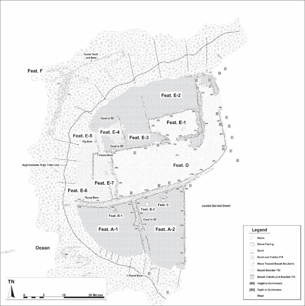
At Kahalu‘u is Kapuanoni Heiau … “Only portions of walls could be traced, 97 feet apart; one of them, a wall foundation, could be followed for 40 feet, and the other, a standing wall 4.5 feet wide, was distinguishable for 34 feet. The place had the appearance of having been much disturbed in early times.”

“It is now overgrown with hau. Local information, from the grandson of its last priest, was that the heiau was built by Kalani‘ōpu‘u and that it was for prayers in general.” (Stokes, 1906) It was “a temple dedicated to agricultural and fishing success.” (NPS)

Thrum (1908) describes Kapuanoni as “a large heiau of Kahaluu, described as an ancient puuhonua and luakini, built in the time of Lono.”

“Tradition has it that when Malaihi was its kahu (or keeper), a native fled to it from Pahoehoe and was followed in by his pursuers, seized, and taken away without remonstrance, which violation coming to the ears of the king he had the keeper slain and sacrificed on the altar of Ohiamukumuku.”

The name “ka pua noni” can be translated literally as ‘the’ (ka) ‘noni flower’ (pua noni). The deeper kaona (meaning) behind this place name has not been passed on. (SWCA)

Kapuanoni is situated on the promontory that forms the southern headland of Kahaluʻu Bay and is surrounded by water on three sides. The heiau formed an integral component of the chiefly and religious compound of coastal Kahalu‘u during the traditional period. (SWCA)

Subsequent to c. 1730s, the chiefs Alapa‘i, Kalani‘ōpu‘u, and Kamehameha I, are all associated with residency and activities in this region of Kona, with specific references to Kahalu‘u and Keauhou. (Maly)

“The years 1775, 1776, 1777, 1778, and 1779. Kalaniopuu went to war at Kaupo on Maui, with his Alii, his war Officers, and his soldiers. Kalaniopuu first went to war at Kaupo …” (Kuakoa, Dec 8, 1866)

“Ka-lani-‘opu‘u returned to Hawaii embittered against Ka-hekili by the realization of his defeat, and spent a year in preparing an army made up of a body or men from each of the six districts of the island, each division led by a warrior chief.” (Kamakau)

“Six army corps or brigades were organised, and became known by the names of I, Ahu, Mahi, Palena, Luahine, and Paia; the members of the royal family were formed into a life-guard, called Keawe; and the Alii-ai-alo – the nobles who had the privilege of eating at the same table with the Moi – composed two regiments called Alapa and Piipii.”

“While thus preparing material resources, Kalaniopuu was not forgetful of his duties to the god whom he acknowledged and whose aid he besought. This god was Kaili – pronounced fully ‘Ku-kaili-moku’ – who, from the days of Liloa, and probably before, appears to have been the special war-god of the Hawaii Mois.” (Fornander)

“[H]e repaired and put in good order the Heiaus called ‘Ohiamukumuku’ at Kahaluu, and ‘Keikipuipui’ at Kailua, in the Kona district, and the high priest Holoae was commanded to maintain religious services and exert all his knowledge and power to accomplish the defeat and death of the Maui sovereign.” (Fornander)  Kalani‘ōpu‘u is also credited with building the heiau of Kapuanoni, presumably during this time. (Maly)

At the time of Captain James Cook’s arrival (1778-1779), the Hawaiian Islands were divided into four kingdoms: (1) the island of Hawaiʻi under the rule of Kalaniʻōpuʻu, who also had possession of the Hāna district of east Maui; (2) Maui (except the Hāna district,) Molokai, Lānai and Kahoʻolawe, ruled by Kahekili; (3) Oʻahu, under the rule of Kahahana; and at (4) Kauai and Niʻihau, Kamakahelei was ruler.

When Cook arrived on the Island of Hawai‘i (1779), Kalaniʻōpuʻu was on the island to Maui to contend with Kahekili, king of Maui. The east side of Maui had fallen into the hands of Kalaniʻōpuʻu and Kahekili was fighting with him to gain control.

Kalaniʻōpuʻu returned to Hawaiʻi and met with Cook on January 26, 1779, exchanging gifts, including an ʻahuʻula (feathered cloak) and mahiole (ceremonial feather helmet.)   Cook also received pieces of kapa, feathers, hogs and vegetables.

“After Captain Cook’s death [in 1779] Kalaniopuu dwelt some time in the Kona district, about Kahaluu and Keauhou, diverting himself with Hula performances, in which it is said that he frequently took an active part, notwithstanding his advanced age. “

“Scarcity of food, after a while, obliged Kalaniopuu to remove his court into the Kohala district, where his headquarters were fixed at Kapaau.” (Fornander)

“During the period of his rule, between c. 1782 to 1819, Kamehameha I was noted for his dedication to his gods and their kapu. Kamakau records that Kamehameha I dedicated the heiau of Kama-i-ke‘e-kū and ‘Ōhi‘a-mukumuku in Kahalu‘u to his war god.”

“In Thrum’s account of Hawaiian temples, readers are told that Kamehameha also built the heiau named Hāpaiali‘i shortly after the battle at Moku‘ōhai in c. 1782. It was through the battle of Moku‘ōhai at Ke‘ei, that Kamehameha I secured a portion of the island of Hawai‘i under his rule.”

“Also, following the death of Kalani‘ōpu‘u the lands of Kahalu‘u and the “two Keauhou” were among those divided between the chiefs.”

“Among the most important ali‘i of the Kamehameha I period associated with Keauhou and Kahalu‘u, was the chiefess Keōpūolani, known in her youth as Wahinepio. She was raised at Keauhou, where she lived until ca. 1795.”

“The daughter of Kïwala‘ō, she was also the sacred wife of Kamehameha I, and mother of the children who succeeded him in rule.” (Maly)

“Kuakini was born in 1791, while his parents lived at Kahalu‘u and Keauhou. Kuakini was a younger brother of Ka‘ahumanu, the favored wife of Kamehameha I, and regarding the birth of Kuakini, and his tie to the lands of Kahalu‘u and Keauhou, Kamakau, recorded that:”

“At the birth of the child [Kuakini] there was a great hula at Kaha-lu‘u, and the name hula (hula inoa) was being danced for the birth of the new son to Na-mahana and Ke‘e-aumoku.”

“Visitors came to bring gifts (ho‘okupu), and among them was Ka-mehe-‘ai-ku who had gone away and hidden in the country and slept with a man and given birth to a child.”

“She was a cousin of Ke‘e-au-moku, and when she was discovered among the spectators at the hula Ke‘e-au-moku gave the child to her to suckle and gave with him the land of Keauhou; and Ka-mehe-‘ai-ku took the little chief to Keauhou and there nourished him until he was grown…” (Kamakau, Maly)

“In 1931, a visitor to nearby Keauhou Bay described Kahalu‘u as ‘miles off the beaten path … a place where people used to live in numbers and now live no more’ (Schench). By the 1950s, the area was mostly abandoned and heavily overgrown”

“In 1970, the Outrigger Keauhou Beach Hotel was constructed just inland of Kapuanoni Heiau. The heiau was situated directly adjacent to the hotel pool.” (SWCA) (The demolition of the Keauhou Beach Hotel was completed in August 2018.) (KSBE)

While some of the walls of the heiau complex remain, the seaward edges of the structure have been badly damaged by high surf events while its interior has been modified by various additions and reconstruction efforts undertaken when it formed part of the grounds of the Outrigger Keauhou Beach Resort.

In 2005, the trustees of Kamehameha Schools decided to restore the five coastal heiau of Kahalu‘u, including Kapuanoni.  Restoration of two heiau (Ke‘ekū and Hāpaiali‘i) was completed in 2009.  Restoration of Makoleā followed that and planning and activities to restore Kapuanoni and Po‘o Hawai‘i pond are underway.

Drone flyover of Kapuanoni: https://www.youtube.com/watch?v=fxsRxa1pimA&t=1s (SWCA)

© 2025 Ho‘okuleana LLC

Filed Under: General, Hawaiian Traditions, Place Names Tagged With: Kahaluu, Kapuanoni, Keeku, Makolea, Hapaialii, Hawaii, Heiau

September 28, 2016 by Peter T Young Leave a Comment

Kona’s Royal Centers

The ‘Peopling of the Pacific’ began about 40,000 years ago with movement from Asia; by BC 1250, people were settling in the eastern Pacific. (Kirch) By BC 800, Polynesians settled in Samoa. (PVS)

Using stratigraphic archaeology and refinements in radiocarbon dating, studies suggest it was about 900-1000 AD that “Polynesian explorers first made their remarkable voyage from central Eastern Polynesia Islands, across the doldrums and into the North Pacific, to discover Hawai‘i.” (Kirch)

“(I)n the earliest times all the people were alii … it was only after the lapse of several generations that a division was made into commoners and chiefs”. (Malo)

Kamakau noted, in early Hawaiʻi “The parents were masters over their own family group … No man was made chief over another.” Essentially, the extended family was the socio, biological, economic and political unit.

Because each ʻohana (family) was served by a parental haku (master, overseer) and each family was self-sufficient and capable of satisfying its own needs, there was no need for a hierarchal structure.

As the population increased and wants and needs increased in variety and complexity (and it became too difficult to satisfy them with finite resources,) the need for chiefly rule became apparent.

As chiefdoms developed, the simple pecking order of titles and status likely evolved into a more complex and stratified structure.

Eventually, a highly stratified society evolved consisting of the aliʻi (ruling class,) kahuna (priestly and expert class of craftsmen, fishers and professionals) and makaʻainana (commoner class.)

Most of the makaʻainana were farmers, a few were fishermen. Tenants cultivated smaller crops for family consumption, to supply the needs of chiefs and provide tributes.

The aliʻi attained high social rank in several ways: by heredity, by appointment to political office, by marriage or by right of conquest. The first was determined at birth, the others by the outcomes of war and political process.

Power and prestige, and thus class divisions, were defined in terms of mana. Although the gods were the full embodiment of this sacredness, the royalty possessed it to a high degree because of their close genealogical ties to those deities.

The kahuna ratified this relationship by conducting ceremonies of appeasement and dedication on behalf of the chiefs, which also provided ideological security for the commoners who believed the gods were the power behind natural forces.

With the stratified social system, it was important to retain the division between aliʻi and makaʻainana. This was done through a physical separation, such as the Royal Centers that were restricted to only the aliʻi and kahuna.

Royal Centers were where the aliʻi resided; aliʻi often moved between several residences throughout the year. The Royal Centers were selected for their abundance of resources and recreation opportunities, with good surfing and canoe-landing sites being favored.

When working on a planning project in Kona, we came across references to “Royal Centers.” In the centuries prior to 1778, seven large and densely-populated Royal Centers were located along the shoreline between Kailua and Hōnaunau.

The compounds were areas selected by the ali‘i for their residences; ali‘i often moved between several residences throughout the year. The Royal Centers were selected for their abundance of resources and recreation opportunities, with good surfing and canoe-landing sites being favored.

The Hawaiian court was mobile within the districts the aliʻi controlled. A Chief’s attendants might consist of as many as 700 to 1000-followers, made of kahuna and political advisors; servants which included craftsmen, guards, stewards; relatives and others. (NPS)

Aliʻi often moved between several residences throughout the year. There was no regular schedule for movement between Royal Centers. In part, periodic moves served to ensure that district chiefs did not remain isolated, or unsupervised long enough to gather support for a revolt. (NPS)

When working on a planning project in Kona, we came across references to “Royal Centers.” In the centuries prior to 1778, seven large and densely-populated Royal Centers were located along the shoreline between Kailua and Honaunau:

  1. Kamakahonu – At Kailua Bay, this was occupied by Kamehameha I between 1813 and 1819.  This was Kamehameha’s compound after unifying the islands under single rule.  The first missionaries landed here, just after the death of Kamehameha I.
  2. Hōlualoa – Three major occupation sequences: Keolonāhihi, A.D. 1300; Keakamahana (mother) and Keakealaniwahine (daughter,) A.D. 1600; and Kamehameha I, A.D. 1780.  It was split into two complexes when Ali‘i Drive was constructed in the 1800s: makai (seaward and west) designated Keolonāhihi State Historical Park; mauka (inland and east) is referred to as Keakealaniwahine’s Residence.
  3. Kahaluʻu – Complex of Lonoikamakahiki ca. 1640-1660, and the oral histories specifically note its use by Alapa‘inui, Kalani‘ōpu‘u and Kamehameha — successive rulers from mid-1740s.  The focus of this center was Kahalu‘u Bay, a sand fringed bay, with a complex of multiple heiau (many recently restored.)
  4. Keauhou – Noted for the largest hōlua slide in Hawai‘i (the volume of stone used in its construction dwarfs that of the largest known temple platforms, making it the largest surviving structure from ancient Hawai‘i.)  This is also the birthplace of Kauikeaouli; stillborn, revived and went on to become Kamehameha III (ca. 1814-1854), last son of Kamehameha I to rule Hawai‘i.
  5. Kaʻawaloa – Home of Kalani‘ōpu‘u, ruling chief in power when Captain Cook sailed into Kealakekua Bay.  Between Ka‘awaloa and Napo‘opo‘o is Pali Kapu O Keōua, a 600′ pali (cliff).  Named for the ali‘i Keōua, who ruled in the mid-1700s, the pali was kapu (off limits) as a sacred burial area.
  6. Kealakekua – Hikiʻau Heiau was dedicated to Lono (god of agriculture and prosperity.)  Kamehameha rededicated Hikiau, “the most important heiau in the district of Kona.” This is where Opukahaʻia had trained to be a kahuna after being orphaned in Kamehameha’s wars. Opukahaʻia fled Hawaiʻi, spent nine years in New England and inspired the first missionaries to come to Hawaiʻi (he died before being able to return with the missionaries to Hawaiʻi.)  When Captain James Cook landed in Kealakekua, he was received by the Hawaiians and honored as the returning god Lono.
  7. Honaunau – Early in the area’s prehistory, a portion of land on the southwest side of the bay was declared a pu‘uhonua (sanctuary protected by the gods – almost every district in the islands had at least one pu‘uhonua in it.)  There kapu breakers, defeated warriors and criminals could find safety when their lives were threatened if they could reach the enclosure before their pursuers caught them.  This way of life began disappearing with Cook’s arrival in 1778 and, ultimately, Liholiho (Kamehameha II) abolished the kapu system in 1819.

Follow Peter T Young on Facebook 

Follow Peter T Young on Google+ 

Follow Peter T Young on LinkedIn  

Follow Peter T Young on Blogger

© 2016 Hoʻokuleana LLC

Kamakahonu map by Rockwood based on Ii-Rechtman
Keauhou_to_Kailua-Aerial
Kamakahonu-Kailua_Bay-HerbKane
Kamakahonu-Kailua_Bay-Choris-1816
Kamakahonu-Kailua_Bay-Landing-Map-Wall-Reg2560 (1913)-Kamakahonu_site_on_left
Holualoa_Bay-Looking_At_Keolohahihi-1890
Holualoa Royal Center
Holualoa_Royal_Center-Kekahuna_Map-Bishop_Museum
Kahaluu-Hapaialii-Keeku-Heiau
Kahaluu-Makolea_Heiau
Kahaluu_Royal_Center-Kekahuna-map
Keauhou-Holua_Slide-(KeauhouResort)
Keauhou-Heeia-Historical_Notes-HenryEPKekahuna-SP_201865
Kealakekua Bay from the village of Kaʻawaloa in the 1820s, from Hiram Bingham I's book
Kealakekua Bay from the village of Kaʻawaloa in the 1820s, from Hiram Bingham I’s book
Kealakekua-John Webber art-1779
Kaawaloa, Kealakekua Bay. A copperplate engraving from a drawing by Lucy or Persis Thurston about 1835
Kaawaloa_(KonaHistoricalSociety)
Kaawaloa-Kalakaua_at_Kealakekua_Bay
Honaunau, engraving by J. Archer after Rev. William Ellis, 1822-1823. Built by Keaweikekahialiʻiokamoku.
Honaunau_Sunset-(HerbKane)
Honaunau-Puuhonua_o_Honaunau-Keokea-Map-1750

Filed Under: Ali'i / Chiefs / Governance, Hawaiian Traditions, Economy, Place Names Tagged With: Kaawaloa, Kamakahonu, Holualoa, Kahaluu, Hawaii, Kona, Royal Center, Honaunau, Kealakekua, Keauhou

Images of Old Hawaiʻi

People, places, and events in Hawaiʻi’s past come alive through text and media in “Images of Old Hawaiʻi.” These posts are informal historic summaries presented for personal, non-commercial, and educational purposes.

Info@Hookuleana.com

Connect with Us

  • Email
  • Facebook
  • LinkedIn
  • Twitter
  • YouTube

Recent Posts

  • Kealakīpapa
  • Hobrons
  • C&H
  • Swim Wear
  • Kohala Shark Hunt
  • Pacific Bakery and Hotel
  • Halo

Categories

  • Schools
  • Sailing, Shipping & Shipwrecks
  • Economy
  • Voyage of the Thaddeus
  • Mayflower Summaries
  • American Revolution
  • General
  • Ali'i / Chiefs / Governance
  • Buildings
  • Missionaries / Churches / Religious Buildings
  • Hawaiian Traditions
  • Military
  • Place Names
  • Prominent People

Tags

Albatross Al Capone Ane Keohokalole Archibald Campbell Bernice Pauahi Bishop Charles Reed Bishop Downtown Honolulu Eruption Founder's Day George Patton Great Wall of Kuakini Green Sea Turtle Hawaii Hawaii Island Hermes Hilo Holoikauaua Honolulu Isaac Davis James Robinson Kamae Kamaeokalani Kamanawa Kameeiamoku Kamehameha Schools Lalani Village Lava Flow Lelia Byrd Liliuokalani Mao Math Mauna Loa Midway Monk Seal Northwestern Hawaiian Islands Oahu Papahanaumokuakea Marine National Monument Pearl Pualani Mossman Queen Liliuokalani Thomas Jaggar Volcano Waikiki Wake Wisdom

Hoʻokuleana LLC

Hoʻokuleana LLC is a Planning and Consulting firm assisting property owners with Land Use Planning efforts, including Environmental Review, Entitlement Process, Permitting, Community Outreach, etc. We are uniquely positioned to assist you in a variety of needs.

Info@Hookuleana.com

Copyright © 2012-2024 Peter T Young, Hoʻokuleana LLC


Loading Comments...