While there is no good place to crash land an airplane, in 1941 the crew of the Army’s B-18 Bolo (serial number 36-446, constructors number 1747) found what was described as the “worst place.”
Prior to September 18, 1947 (the time the US Air Force was formed,) military aviation was conducted by the Army or Navy.
But let’s step back a bit.
In 1935, a design competition and “fly-off” was held to select a replacement for the Martin B-10/12 the standard bomber then in service with the United States Army Air Corps (USAAC.)
Douglas developed the B-18 “Bolo” to replace the Martin B-10; the new model was based on the Douglas DC-2 commercial transport. The B-18 prototype competed with the Martin 146 (an improved B-10) and the four-engine Boeing 299, forerunner of the B-17 Flying Fortress, at the Air Corps bombing trials at Wright Field in 1935.
Although many Air Corps officers judged the Boeing design superior, the Army General Staff preferred the less costly Bolo; contracts were awarded for 82-planes, the order was increased to 132 by June of 1936.
Although designated a reconnaissance and bomber aircraft, the Douglas B-18 flew other important missions. Hickam B-18s towed targets for gunnery practice by the coast artillery ground troops. The targets were attached to steel cables and reeled several hundred feet aft of the aircraft. (Trojan)
Though equipped with inadequate defensive armament and underpowered, the Bolo remained the Air Corps’ primary bomber into 1941. Thirty-three B-18s were based in Hawaiʻi with the 5th Bombardment Group and 11th Bombardment Group.
One of those Hawaiʻi B-18 Bolos, piloted by Boyd Hubbard Jr, took off from Hickam Field at 7 pm February 25, 1941 for a routine inter-island night instrument-navigation training flight. Three other B-18s trained with them that night.
Their flight path took them over the Island of Hawaiʻi. While flying on instruments at 10,000-feet, Hubbard’s B-18 suffered a main bearing failure in the left engine. Hubbard headed to Suiter Field, the Army’s auxiliary field (it is now known as Upolū Point Airport.)
Although all possible fuel and cargo was jettisoned, the aircraft was too heavily loaded to maintain altitude on one engine. As the aircraft descended the other engine began sputtering. The crew believed they were over the ocean at the time in heavy fog during the dark night.
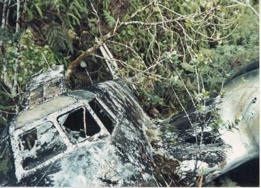
Hubbard made a last split-second correction prior to the crash. As he later described it, the mountain just loomed up before him in the darkness and he just reacted. He pulled back hard on the wheel and the aircraft stalled and belly flopped into the thick underbrush.
The undergrowth was so dense the plane settled into it and did not slide forward very far. The crew felt the plane hit the tops of some trees and skid for about 75 yards before coming to rest at about the 3500-foot elevation in a gulch on the side of the Kohala mountain. (Trojan)
Lee Webster, a Flight Engineer on one of the other B-18s in the group, reportedly gave this account of the accident, “I was just becoming accustomed to the eerie feeling of night flying by the time we started our second leg of the triangle toward a point somewhere off the northern tip of the island and to this point radio contact led us to believe we were in good shape.”
“Suddenly that was shattered by a report from one of the other planes having engine problems and then soon after a report of engine failure and that they were losing altitude. We immediately broke off our mission to accompany the disabled aircraft into Hilo airport, but to make matters worse we flew into some very bad weather. After what seemed a short period of time we lost radio contact with them and when attempts to locate the lost plane became futile we returned to Hickam Field.” (Trojan)
The next morning at dawn a search was launched from Hickam Field using 24 bombers. The wreck was soon spotted and an airdrop from Army planes provided the downed crew with blankets, food and hot coffee.
At dawn the following day (Thursday, February 27,) a rescue team departed from Suiter Field (Upolū.) Members of the rescue party included Fred C Koelling (leader,) Ronald May, Leslie Hannah, Melvin Johnson and Hiroshi Nakamura. (Pacific Wrecks)
They took the Kohala Ditch Trail on horseback for 2 ½-hours, then had to cut a new trail on foot for 8-miles through marshland and heavy brush for another 4-hours before nearing the crash site.
Firing pistols into the air to attract the downed fliers’ attention; the air crew responded with a burst of bullets and shot flares into the air; after 12-hours, they reached the downed plane. (Veronico)
Remarkably, only minor injuries were sustained by Hubbard and the crew (crew members were Co-Pilot 2nd Lt Francis R Thompson; Engineer SSgt Joseph S. Paulhamus; Radioman Pvt William Cohn; Crewman Pvt Fred C Seeger and Crewman Pvt Robert R Stevens.)
Airmen from Hickam later described the site as the “Worst possible place for a forced landing in the Islands.” (Trojan)
Hubbard continued on with a distinguished career in the Army, retiring as Brigadier General and earning Legion of Merit with oak leaf cluster; Distinguished Flying Cross with oak leaf cluster; Bronze Star Medal and numerous other medals, badges and citations. (He retired March 1, 1966; he died February 15, 1982.)
The plane sat since on the side of Kohala mountain, just west of Waimanu Valley. While various internet reports suggest Pacific Aviation Museum acquired the plane and has plans to restore and display it, the Curator of the Museum noted to me that “the plane is not ours”. It continues to sit on the slopes of Kohala in Hāmākua.