Images of Old Hawaiʻi

  • Home
  • About
  • Categories
    • Ali’i / Chiefs / Governance
    • American Protestant Mission
    • Buildings
    • Collections
    • Economy
    • Missionaries / Churches / Religious Buildings
    • General
    • Hawaiian Traditions
    • Other Summaries
    • Mayflower Summaries
    • Mayflower Full Summaries
    • Military
    • Place Names
    • Prominent People
    • Schools
    • Sailing, Shipping & Shipwrecks
    • Voyage of the Thaddeus
  • Collections
  • Contact
  • Follow

April 17, 2023 by Peter T Young Leave a Comment

The Battle of Hōkūʻula

Prominent features rising above the town of Waimea on the Big Island are the puʻu (cinder cones) in the surrounding pasture.  The South Kohala community made special note of these physical features in the Community Development Plan noting, “the Puʻu define the special landscape ‘sense of place’ of Waimea.”

One of these, Hōkūʻula (red star,) played a prominent role in battles between warring leadership from the islands of Maui and Hawaiʻi.  This story dates back to about the mid-1600s.

To put this timeframe in global perspective, around this time: the Ming Dynasty in China ended and the Manchus came into power and established the Qing dynasty; the Taj Mahal was completed in India: British restored the monarchy and Charles II was crowned king of England; and the Massachusetts Bay colony was forming after the recent landing of the Pilgrims at Plymouth Rock.

In the islands, Lonoikamakahiki (Lono) was the Mōʻi (Chief) of Hawai‘i.  He was a descendant of Pili (a high chief from Tahiti from the 13th century.  Lono was grandson of ʻUmi (and great grandson of Līloa.))

“Lono-i-ka-makahiki was a son of Keawe-nui-a-Umi, and was chief of Ka-u and Puna. He was sole ruler over those two districts on Hawaii. He was married to a chiefess, named Ka-iki-lani-kohe-paniʻo, who was descended from Laea-nui-kau-manamana. To them were born sons, Keawe-Hanau-i-ka-walu and Ka-ʻihi-kapu-mahana.”   (Kamakau)

Through marriage and victories over other chiefs, Lonoikamakahiki became the ruler of the Island of Hawaiʻi.  “During Lono’s reign, when he tended to the affairs of his kingdom, the chiefs and commoners lived in peace.”  (Kamakau)

Lono visited the Mōʻi of the various islands, including Kamalālāwalu, ruling chief of Maui.  “Lono-i-ka-makahiki sought the good will of these chiefs when he came to meet and associate with them in a friendly manner. There were to be no wars between one chief and another.”  (Kamakau)

Kamalālāwalu (Kama) met him and welcomed him royally.  The chiefly host and guest spent much time in surfing, a sport that was enjoyed by all.  Lono was lavishly entertained by Kamalālāwalu.

Not long after Lono’s departure and return to Hawai‘i, however, Kamalālāwalu, driven by ambition, decided to invade and conquer the nation of Island of Hawai‘i.  He sent spies to survey the opposition; they reported there were few men in the Kohala region.

When Kamalālāwalu heard the report of his spies, he was eager to stir his warriors to make war on Hawaiʻi.  Most of the prophets and seers supported the chief’s desire and gave dogs as their omen of victory [said that clouds taking the form of dogs foretold victory]. The dogs were a sign of fierceness, and so would the chief fiercely attack the enemy and gain the victory with great slaughter of the foe.

Part of the prophets and seers came to the chief with prophecies denying his victory, and urging him not to go to fight against Hawaiʻi.  When Lanikāula, a high priest from Moloka‘i, warned Kamalālāwalu of the dangers of an assault, an irate Kamalālāwalu replied “when I return, I will burn you alive.” (Fornander)

Kamalālāwalu’s fleet landed in Puakō and met no opposition. Lono’s oldest brother, Kanaloakuaʻana, was in residence Waimea at the time, and, upon hearing of the invasion, marched toward Puakō with what forces he had at hand. A battle ensued at Kauna‘oa (near the present-day Mauna Kea Resort), and Kanaloakuaʻana’s forces were defeated, with Kanaloakuaʻana himself being taken prisoner and eventually killed.

After this initial success, Kamalālāwalu and his Maui warriors marched boldly inland and took up a position above Waimea on top of the puʻu called Hōkūʻula and awaited Lono’s forces.

During the night, Lono’s warriors from Kona arrived and occupied a position near Puʻupā (the large cinder cone makai of the Waimea-Kohala Airport.) His warriors from Kaʻū (led by its high chief and Lono’s half-brother, Pupuakea) and Puna were stationed from the pu‘u called Holoholoku (the large cinder cone out in the plains below Mauna Kea,) those from Hilo and Hāmākua were stationed near Mahiki, and those from Kohala were stationed on the slopes of Momoualoa.

That morning, from his position atop Hōkūʻula, Kamalālāwalu could see that the lowlands were literally covered with the countless warriors of Lono, and realized that he was outnumbered. For three days the armies skirmished, with the actions of the Maui warriors being dominated by Kamalālāwalu’s nephew and chief, Makakuikalani.

“Short and long spears were flung, and death took its toll on both sides. The Maui men who were used to slinging shiny, water-worn stones grabbed up the stones of Puʻoaʻoaka. A cloud of dust rose to the sky and twisted about like smoke, but the lava rocks were light, and few of the Hawaii men were killed by them.”  (Kamakau)

“The warriors of Maui were put to flight, and the retreat to Kawaihae was long. [Yet] there were many who did reach Kawaihae, but because of a lack of canoes, only a few escaped with their lives. Most of the chiefs and warriors from Maui were destroyed.”  (Kamakau)

While Kamakau notes Kamalālāwalu died on the grassy plain of Puakō, other tradition suggests that after Lonoikamakahiki defeated Kamalālāwalu at Hōkūʻula, he brought the vanquished king of Maui to Keʻekū Heiau in Kahaluʻu and offered him as a sacrifice.

The spirits of Kamalālāwalu’s grieving dogs, Kauakahiʻokaʻoka (a white dog) and Kapapako (a black dog,) are said to continue to guard this site.  Outside the entrance to the heiau and towards the southwest are a number of petroglyphs on the pāhoehoe.  One of them is said to represent Kamalālāwalu.

So ended the first of the major wars between the nations of Maui and Hawai‘i, and a turning point in the history of Hawai‘i.

(Puʻu Hōkūʻula is sometimes referred as “”Buster Brown.”  Apparently, while training at Camp Tarawa in Waimea, Marines named it Buster Brown Hill after the former section manager for Parker Ranch, who lived just below the hill.)

© 2023 Hoʻokuleana LLC

Filed Under: Hawaiian Traditions, Ali'i / Chiefs / Governance Tagged With: Kamalalawalu, Kamuela, Hawaii, Lonoikamakahiki, Maui, Umi-a-Liloa, Waimea, Camp Tarawa, Kawaihae, Puako, Hokuula

April 16, 2023 by Peter T Young Leave a Comment

St Peter’s Chapel

“There are a few, very small fishing villages, Alae, Alika and Papa, which are reached by poor trails from the mauka road. It is necessary to travel from Hookena mauka to the main road to Papa, and thence by either road or trail to Hoopuloa, the last steamship landing in Kona.”

“This is another village which is dwindling in population, only a few Hawaiians and a couple of Chinese storekeepers remaining. A fair road leads across a barren a-a flow to Miloli‘i, the largest and best specimen of an exclusively Hawaiian village on the Island, which is seldom visited.”

“It is splendidly situated by a sand beach, the sea coming right up to the yard wall, and is inhabited by a rather large population of Hawaiians, who prosper through the fishing which is almost phenomenally good…”

“This region is seldom visited. Its chief points of interest are the remains of a heiau, mauka of the Catholic church at Milolii, some fine papa konane at the south end of the same village a well preserved kuula (still used) where fishermen offer offerings of fruit to insure a good catch, by the beach south of Milolii, where the Honomalino Ranch fence crosses the trail; while all along the trail are smaller kuulas, and at many points the foundations of villages, where old implements may still be found.” (Kinney, 1913)

“Hoopuloa was one of the few typically Hawaiian villages remaining in Hawaii. It comprised of a cluster of 10 to 15 homes of old Hawaiian style and boasted a population of approximately 100 persons … The wharf was a port of call for the Inter-Island steamers”. (Honolulu Star Bulletin, April 19, 1926)

Then … “The number of earthquakes recorded for April [1926] was 671 (compared with monthly average of 52 for the preceding 3 months. … The maximum daily frequency of earthquakes in the 1926 eruption was on April 15 (86 shock), the first day of free-flowing flank eruption …” (Jaggar)

Edward G Wingate, USGS topographical engineer, was mapping the summit of Mauna Loa in 1926, changing campsites as the work progressed. On April 10 his camp was along the 11,400-foot elevation, well into the desolate upland above the Kau District.

An earthquake wakened the campers about 0145; as they drifted back to sleep, a further series of quakes had them sitting up, talking, and wondering. About 0330 Wingate braved the cold and wind; with a blanket wrapped around him, he went outside and stood bathed in reddish light.  (USGS)

There was a brief summit eruption, followed by 14 days of eruption on the southwest rift zone.  “About 3 am April 10 (1926,) glowing lava spouted along the upper 3 miles of cones and pits of the Mauna Loa rift belt, immediately south of Mokuʻāweoweo, the summit crater.  … The actual beginning shown at Kilauea by seismographic tremor was 1:36 am, followed by two pronounced earthquakes.”    (Jaggar)

For three days the HVO party surveyed the sources of the eruption; then they descended and moved into Kona District, where roads, houses, and other property were threatened by the flows. Wingate and his crew stayed behind. Much of the area already mapped was under fresh lava, and there was a lot of remapping to do.  (USGS)

“A crack only 1 to 3 feet wide opened southward from a point tangent to the ease edge of the bottom of the south pit of Mokuʻāweoweo, vomited out pumiceous silvery pāhoehoe froth lava, and extended itself S.30oW. past the next two pits and over the brow of the mountain down to an elevation of 12,400 feet.”  (Jaggar)

“Fortunately the main gushing of this first phase ceased about 5 am the same forenoon, after flowing 5 hours. … (Then,) The vent crack was splitting itself open downhill. The source pāhoehoe changed itself by stirring into scoriaceous aa half a mile from the vents”. (Jaggar)

“When it got close to the upland of Hoʻopuloa, the flow of lava separated into two, and one of the flows went straight for the village of Hoʻopuloa and the harbor, and the second flow went towards the village of Miloliʻi.”  (Hoku o Hawaii, April 20, 1926)  

“(T)he Honomalino flow to the west finally dominated, … This was also aa. … It crossed the belt road at 12:22 pm April 16, 3 miles above Hoʻopuloa village.” (Jaggar)

On April 16, Jaggar scratched marks about a foot apart across the rutted, gravel road (the only road) between the Kona and Kau Districts. A lava flow was approaching, and Jaggar wanted to measure the flow’s speed as it crossed the road.

St Peter’s Chapel, sometimes referred to as Ho‘opuloa Catholic Church, was on the makai side of the road.  Perhaps a hundred people were waiting around the Hoʻopuloa Church, on the uphill side of the road, and at the Kana‘ana house opposite, on the downhill side of the road.

They had seen and heard the flow, 15-20 feet high and more than 500 feet wide, as it moved through the forest uphill.  When it neared the road, people who lived on the Kona side of the flow moved off to the north, and those who lived on the Ka‘u side moved to the south, so they could go home after the road was closed.  (USGS)

Jaggar recorded that it reached the uphill, inland side of the road at 12:22 at an estimated speed of about 7 feet/minute; within two minutes the road was crossed. Jaggar and his assistant, HS Palmer, stayed on the Ka‘u side.  (USGS)  St Peter’s Chapel, sometimes referred to as Ho‘opuloa Catholic Church, was on the makai side of the road.

“The Catholic church, where many Hawaiians worshipped, was one of the first building to be destroyed in the flow which buried Hoopuloa.”  (The Star, NZ, May 21, 1926)

“It is true that I saw the church destroyed by the lava tide, which moved onward with irrevocable majesty, entering the house of worship by way of the open front door.”

“Through the windows I observed the red mass proceed to the alter as the whole structure, capable of seating 20 worshipers, burst into flames.”

“Most dramatic of all was the moment when the slow moving red-hot deluge, pressed on by the mass of lava from the rear, tipped the church from its foundations and set it careening upon the molten river.”

“Straightaway, the bell, which hung in an open steeple, began ringing. It pealed above the roar of the flames and the grinding of the blazing substance surging onward.”

“A dozen doleful strokes of the iron tongue echoed farewell before it fell from the cross beam ringing its own requiem.”  (Father Eugene Oehman, Honolulu Advertiser, July 31, 1932)

A memorial to the church was erected; the plaque on the monument reads “1926 Hoopuloa Catholic Church.” “Under the cross, 25 feet below the surface is all that remains of a small Catholic church, over which the lava flowed without a moment’s halt.” (Honolulu Advertiser, July 31, 1932)

“The fiery lava engulfed the harbor and village of Hoʻopuloa, and now they are but a heap of pāhoehoe lava.” (Hoku o Hawaii, April 20, 1926)

“Families of Ho‘opuloa were forced out of their homes by the flow, and many eventually settles in Miloli‘i on state land.  The displace families remained on the land although they had no legal title to the property.” (Hawaii Tribune Herald, July 10, 1985)

In 1932, St. Peter’s Catholic Church at Miloli‘i was built by Father Steffen to replace an earlier St. Peterʻs destroyed by the 1926 lava flow. (PaaPonoMilolii)

In 1982, the State Legislature passed Act 62 which designated 52.6 acres of state land to be leased to the refugees and the descendants of the Ho‘opuloa lava flow.”

The Act also created the criteria by which people could qualify fo5 65-year leases”  Initial implementation of the Act took place July 12, 1985 with the signing of 12 long-term leases for families living on the designated property.  (Hawaii Tribune Herald, July 10, 1985)

© 2023 Ho‘okuleana LLC

Filed Under: General, Missionaries / Churches / Religious Buildings Tagged With: South Kona, St Peter's Chapel, Hoopuloa Catholic Church, 1926, Hawaii, Eruption, Mauna Loa, Hoopuloa

April 15, 2023 by Peter T Young Leave a Comment

Wind, Wings and Waves

Hawaiʻi is the world’s most-isolated, populated-place, we are about: 2,500-miles from the US mainland, Samoa & Alaska; 4,000-miles from Tokyo, New Zealand & Guam, and 5,000-miles from Australia, the Philippines & Korea.
 
We are surrounded by a vast ocean and sometimes naively feel isolated, separated and protected from outside threats and negative impacts.  Unfortunately, we take too much for granted.
 
Formation of Hawaiian Island chain started more than 70 million years ago.  Yet despite millions of years of isolation, plants, animals and insects found their way to Hawaiʻi … on Wind, Wings and Waves.
 
Some seeds, spores and insects arrived on the wind.  A few birds flew or were blown off course; in them or stuck to their feathers were more seeds.  Some seeds managed to float here on ocean currents or waves.  Ocean currents also carried larval forms of fish, invertebrates, algae and even our freshwater stream species.
 
It is estimated that one plant or animal arrived and successfully colonized every 30,000 years.  Over millions of years in isolation, these original plant and animal species changed, forming into our native species.
 
The first alien species arrived with Polynesians in the year 300 A.D. or so. In 1778, Hawaiʻi was placed on the world map; and so started new invasive species pathways.
 
It is estimated that in the last 230+ years, as many as 10,000 plants have been introduced: 343 new marine/brackish water species; Hawaiʻi went from 0 native land reptiles to 40; 0 amphibians to 6 (including coqui) and there is a new insect in Hawaiʻi every day.
 
The greatest threat to Hawaiʻi’s native species is invasive species.
 
Hawaiʻi has the dubious distinction of being called the endangered species capital of the world and unfortunately leads the nation in endangered species listings with 354 federally listed threatened or endangered listed species.
 
With only 0.2% of the land area of the United States, nearly 75% of the nation’s historically documented plant and bird extinctions are from Hawaiʻi.  We have more endangered species per square mile on these islands than any other place on Earth.
 
Impacts from invasive species are real and diverse: Tourism and agriculture-based economy; Forests’ ability to channel rainwater into our watersheds; Survival of native species found nowhere else; Health of residents and visitors; and Quality of life that makes Hawaiʻi a special place.
 
Today, the pathways to paradise are diverse, including: air & ship cargo; ship hulls & ballast water; hand-carry/luggage; mail & freight forwarders; forestry activities; horticulture trade; aquaculture; pet trade; botanical gardens and agriculture experiment stations (or simply on you and your clothing.)
 
While I was at DLNR, we formed and I co-chaired the Hawai‘i Invasive Species Council, a multi-jurisdictional agency, established to provide policy level direction, coordination, and planning among state departments, federal agencies, and international and local initiatives.
 
Our focus was primarily on two actions: the control and eradication of harmful invasive species infestations throughout the State; and prevention the introduction of other invasive species that may be potentially harmful.
 
We must continue to be vigilant in stopping new pests from coming in and eradicating those that have already made it to our shores.
 
We share a common goal.  Whether your concern is in having enough water, healthy reefs, diverse forests, a healthy economy or a healthy family, we all want the same thing:  To make and keep Hawaiʻi a great place to live.
 
© 2023 Ho‘okuleana LLC
 

Filed Under: General Tagged With: Hawaii, Invasive Species, Native Species, HISC, Hawaii Invasive Species Council

April 12, 2023 by Peter T Young 1 Comment

Threes and Eights

No, it’s not a typo (I don’t mean black Aces and Eights, Wild Bill Hickock’s “dead man’s hand”;) this relates to Noah Webster, Henry ʻŌpūkahaʻia, and Hawaiian grammar and spelling.

How in the world are these in common? … Let’s look.

Noah Webster (1758-1843) was the man of words in early 19th-century America. He compiled a dictionary which became the standard for American English; he also compiled The American Spelling Book, which was the basic textbook for young readers in early 19th-century America.

ʻŌpūkahaʻia, in 1809, boarded a sailing ship anchored in Kealakekua Bay and sailed to the continent.  ʻŌpūkahaʻia latched upon the Christian religion, converted to Christianity in 1815 and studied at the Foreign Mission School in Cornwall, Connecticut (founded in 1817) – he wanted to become a missionary and teach the Christian faith to people back home in Hawaiʻi.

A story of his life was written (“Memoirs of Henry Obookiah” (the spelling of his name prior to establishment of the formal Hawaiian alphabet, based on its sound.))  This book was put together by Edwin Dwight (after ʻŌpūkahaʻia died.)  It was an edited collection of ʻŌpūkahaʻia’s letters and journals/diaries.

This book inspired the New England missionaries to volunteer to carry his message to the Sandwich Islands.

On October 23, 1819, the pioneer Company of missionaries from the northeast United States, set sail on the Thaddeus for the Sandwich Islands (now known as Hawai‘i) – they first landed at Kailua-Kona on April 4, 1820.  (Unfortunately, ʻŌpūkahaʻia died suddenly (of typhus fever on February 17, 1818) and never made it back to Hawaiʻi.)

OK, so what about the 3s and 8s – and Hawaiian grammar and spelling?

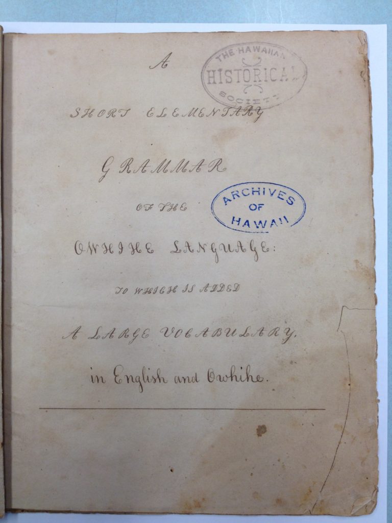
It turns out that a manuscript was found among Queen Emma’s private papers (titled, “A Short Elementary Grammar of the Owhihe Language;”) a note written on the manuscript said, “Believed to be Obookiah’s grammar”.

Some believe this manuscript is the first grammar book on the Hawaiian language. However, when reading the document, many of the words are not recognizable.  Here’s a sampling of a few of the words: 3-o-le; k3-n3-k3; l8-n3 and; 8-8-k8.

No these aren’t typos, either.  … Let’s look a little closer.

In his journal, ʻŌpūkahaʻia first mentions grammar in his account of the summer of 1813: “A part of the time [I] was trying to translate a few verses of the Scriptures into my own language, and in making a kind of spelling-book, taking the English alphabet and giving different names and different sounds. I spent time in making a kind of spelling-book, dictionary, grammar.”  (Schutz)

So, where does Noah Webster fit into this picture?

As initially noted, Webster’s works were the standard for American English.  References to his “Spelling” book appear in the accounts by folks at the New England mission school.

As you know, English letters have different sounds for the same letter.  For instance, the letter “a” has a different sound when used in words like: late, hall and father.

Noah Webster devised a method to help differentiate between the sounds and assigned numbers to various letter sounds – and used these in his Speller.  (Webster did not substitute the numbers corresponding to a letter’s sound into words in his spelling or dictionary book; it was used as an explanation of the difference in the sounds of letters.)

The following is a chart for some of the letters related to the numbers assigned, depending on the sound they represent.

Long Vowels in English (Webster)
..1……..2…….3………4……….5…….6………7……….8
..a……..a…….a………e……….i……..o………o……….u
late, ask, hall, here, sight, note, move, truth

Using ʻŌpūkahaʻia’s odd-looking words mentioned above, we can decipher what they represent by substituting the code and pronounce the words accordingly (for the “3,” substitute with “a”(that sounds like “hall”) and replace the “8” with “u,” (that sounds like “truth”) – so, 3-o-le transforms to ʻaʻole (no;) k3-n3-k3 transforms to kanaka (man;); l8-n3 transforms to luna (upper) and 8-8-k8 transforms to ʻuʻuku (small.)

It seems Henry ʻŌpūkahaʻia used Webster’s Speller in his writings and substituted the numbers assigned to the various sounds and incorporated them into the words of his grammar book (essentially putting the corresponding number into the spelling of the word.)

“Once we know how the vowel letters and numbers were used, ʻŌpūkahaʻia’s short grammar becomes more than just a curiosity; it is a serious work that is probably the first example of the Hawaiian language recorded in a systematic way. Its alphabet is a good deal more consistent than those used by any of the explorers who attempted to record Hawaiian words.” (Schutz)

“It might be said that the first formal writing system for the Hawaiian language, meaning alphabet, spelling rules and grammar, was created in Connecticut by a Hawaiian named Henry ʻŌpūkahaʻia.  He began work as early as 1814 and left much unfinished at his death in 1818.” (Rumford)

“His work served as the basis for the foreign language materials prepared by American and Hawaiian students at the Foreign Mission School in Cornwall, Connecticut, in the months prior to the departure of the first company of missionaries to Hawai’i in October 1819.”  (Rumford)

It is believed ʻŌpūkahaʻia classmates (and future missionaries,) Samuel Ruggles and James Ely, after ʻŌpūkahaʻia’s death, went over his papers and began to prepare material on the Hawaiian language to be taken to Hawaiʻi and used in missionary work (the work was written by Ruggles and assembled into a book – by Herman Daggett, principal of the Foreign Mission School – and credit for the work goes to ʻŌpūkahaʻia.)

Lots of information here from Rumford (Hawaiian Historical Society) and Schutz (Honolulu and The Voices of Eden: A History of Hawaiian Language Studies.)

I encourage you to review the images in the folder; I had the opportunity to review and photograph the several pages of ʻŌpūkahaʻia’s grammar book.

© 2023 Hoʻokuleana LLC


Filed Under: General, Missionaries / Churches / Religious Buildings Tagged With: Hawaii, Noah Webster, Henry Opukahaia, Hawaiian Mission Houses Historic Site and Archives, Hawaiian Language, Hawaiian

April 11, 2023 by Peter T Young Leave a Comment

Whose Footprints Are These?

Geologic evidence suggests that the modern caldera of Kīlauea formed shortly before 1500 AD. Repeated small collapses may have affected parts of the caldera floor, possibly as late as 1790. For over 300-400 years, the caldera was below the water table.

Kilauea can be an explosive volcano; several phreatic eruptions have occurred in the past 1,200 years.  (Phreatic eruptions, also called phreatic explosions, occur when magma heats ground or surface water.)

The extreme temperature of the magma (from 932 to 2,138 °F) causes near-instantaneous evaporation to steam, resulting in an explosion of steam, water, ash and rock – the 1980 eruption of Mount St. Helens was a phreatic eruption.

The 1924 eruption at Halemaʻumaʻu documents and illustrates the explosive nature of Kilauea.  However, the 1924 explosions were small by geologic standards and by the standards of some past Kilauea explosions.

The hazards of larger explosions, such as those that took place multiple times between about AD 1500 and 1790, are far worse than those associated with the 1924 series.  (USGS)

There were explosions in 1790, the most lethal known eruption of any volcano in the present United States. The 1790 explosions, however, simply culminated (or at least occurred near the end of) a 300-year period of frequent explosions, some quite powerful.  (USGS)

Keonehelelei is the name given by Hawaiians to the explosive eruption of Kilauea in 1790.  It is probably so named “the falling sands” because the eruption involved an explosion of hot gas, ash and sand that rained down across the Kaʻu Desert.  The character of the eruption was likely distinct enough to warrant a special name.  (Moniz-Nakamura)

At the time, Kaʻū Chief Keōuakūʻahuʻula (Keōua) was the only remaining rival of Kamehameha the Great for control of the Island of Hawaiʻi; Keōua ruled half of Hāmākua and all of Puna and Kaʻū Districts.  They were passing through the Kilauea area at the time of the eruption. The 1790 explosion led to the death of one-third of the warrior party of Keōua.  (Moniz-Nakamura)

Camped in Hilo, Keōua learned of an invasion of his home district of Kaʻū by warriors of Kamehameha. To reach Kaʻū from Hilo, Keōua had a choice of two routes one was the usually traveled coastal route, at sea level, but it was longer, hot, shadeless and without potable water for long distances.  (NPS)

The other route was shorter, but passed over the summit and through the lee of Kilauea volcano, an area sacred to, and the home of, the Hawaiian volcano goddess Pele. Keōua chose the volcano route, perhaps because it was shorter and quicker, with water available frequently.  (NPS)

In 1919, Ruy Finch, a geologist at the Hawaiian Volcano Observatory discovered human footprints fossilized in the Kaʻū desert ash. Soon, this area of the desert became known as “Footprints.”

Barefoot walkers left thousands of footprints in wet volcanic ash within a few miles southwest of Kīlauea’s summit.

Many historians and Hawaiians believe the footprints were made by Keōua and his warriors.  Keōua was known to be in the area at the time, and previous thought suggested this part of the desert did not have pre-contact use, so it was narrowed down to them.

Scientists later investigated – one approach was to look deeper at the evidence.

Forensic studies indicate that the length of a human foot is about 15% of an individual’s height. A man’s foot may be slightly more that 15%, a woman’s slightly less, but it is possible to estimate the height to a couple of inches.  (USGS)

They measured 405-footprints to determine how tall the walkers were.  The average calculated height is only 4-feet 11-inches, and few footprints were made by people 5-feet 9-inches or more tall. Early Europeans described Hawaiian warriors as tall; one missionary estimated an average height of 5-feet 10-inches. Many now believe that most of the footprints were made by women and children, not by men, much less warriors.  (USGS)

Meanwhile, Keōua’s party was camped on the upwind side of Kīlauea’s summit – perhaps on Steaming Flat – waiting for Pele’s anger to subside. They saw the sky clear after the ash eruption and began walking southwestward between today’s Volcano Observatory and Nāmakanipaio.  (USGS)

Suddenly, the most powerful part of the eruption began, developing a high column and sending surges at hurricane velocities across the path of the doomed group. Later, survivors and rescuers made no footprints in the once wet ash, which had dried.  (USGS)

Then, archaeologists looked for other evidence to help identify who the footprints may have belonged to.  Contrary to general thought that the area was not used by the Hawaiians, archaeological investigations discovered structures, trails and historic artifacts in the area.  (Moniz-Nakamura)

Most of the features were along the edge of the Keʻāmoku lava flow.  Several of the trails converge south of the flow, suggesting a major transportation network.  The structures are likely temporary, used as people were traversing through the desert on their way to/from Kaʻū and Hilo.  (Moniz-Nakamura)

The sheer number of temporary shelters along the Keʻāmoku flow, as well as the trail systems and quarry sites, strongly suggest that this area was frequently used by Hawaiians travelling to and through the area – before and after the 1790 eruption.  (Moniz-Nakamura)

If the footprints aren’t Keōua’s warriors, then how did one-third of his warriors die?

Several suggestions have been made: suffocation due to ash; lava, stones, ash and other volcanic material; or strong winds produced by the eruption, asphyxiation and burning killed them.  (Moniz-Nakamura)

A more recent suggestion is that a “hot base surge, composed primarily of superheated steam … (traveling at) hurricane velocity” was the cause of death.  The wind velocity prevented the people from running away; they probably huddled together, then “hot gases seared their lungs.”  (Moniz-Nakamura)

Some now suggest that, if these observations and ideas are correct, the footprints were made in 1790, but not by members of Keōua’s group.  (USGS)

A reconstruction of events suggests that wet ash, containing small pellets, fell early in the eruption, blown southwestward into areas where family groups, mainly women and children, were chipping glass from old pāhoehoe. They probably sought shelter while the ash was falling. Once the air cleared, they slogged across the muddy ash, leaving footprints in the 1-inch thick deposit.  (USGS)

On August 1, 1916, President Woodrow Wilson signed the country’s 13th national park into existence – Hawaiʻi National Park.  At first, the park consisted of only the summits of Kilauea and Mauna Loa on Hawaiʻi and Haleakalā on Maui.

Eventually, Kilauea Caldera was added to the park, followed by the forests of Mauna Loa, the Kaʻū Desert, the rain forest of Olaʻa and the Kalapana archaeological area of the Puna/Kaʻū Historic District.

In 1961, Hawaiʻi National Park’s units were separated and re-designated as Haleakalā National Park and Hawaii Volcanoes National Park.) (Lots of good information here is from USGS, NPS and Jade Moniz-Nakamura.)

© 2023 Hoʻokuleana LLC


Filed Under: General, Hawaiian Traditions Tagged With: Volcano, Kilauea, Kamehameha, Hawaii Volcanoes National Park, Kau, Keoua, Haleakala National Park, Hawaii National Park, Keonehelelei, Hawaii, Halemaumau, Hawaii Island

  • « Previous Page
  • 1
  • …
  • 204
  • 205
  • 206
  • 207
  • 208
  • …
  • 572
  • Next Page »

Images of Old Hawaiʻi

People, places, and events in Hawaiʻi’s past come alive through text and media in “Images of Old Hawaiʻi.” These posts are informal historic summaries presented for personal, non-commercial, and educational purposes.

Info@Hookuleana.com

Connect with Us

  • Email
  • Facebook
  • LinkedIn
  • Twitter
  • YouTube

Recent Posts

  • ʻĪmaikalani
  • About 250 years Ago … Give Me Liberty, Or Give Me Death
  • Herbert, William & Jack
  • Lake Waiau
  • Silva’s Stores
  • Jones Act
  • Lady in Waiting

Categories

  • Ali'i / Chiefs / Governance
  • Buildings
  • Missionaries / Churches / Religious Buildings
  • Hawaiian Traditions
  • Military
  • Place Names
  • Prominent People
  • Schools
  • Sailing, Shipping & Shipwrecks
  • Economy
  • Voyage of the Thaddeus
  • Mayflower Summaries
  • American Revolution
  • General

Tags

Albatross Al Capone Ane Keohokalole Archibald Campbell Bernice Pauahi Bishop Charles Reed Bishop Downtown Honolulu Eruption Founder's Day George Patton Great Wall of Kuakini Green Sea Turtle Hawaii Hawaii Island Hermes Hilo Holoikauaua Honolulu Isaac Davis James Robinson Kamae Kamaeokalani Kameeiamoku Kamehameha Schools Lalani Village Lava Flow Lelia Byrd Liberty Ship Liliuokalani Mao Math Mauna Loa Midway Monk Seal Northwestern Hawaiian Islands Oahu Papahanaumokuakea Marine National Monument Pearl Pualani Mossman Quartette Thomas Jaggar Volcano Waikiki Wake Wisdom

Hoʻokuleana LLC

Hoʻokuleana LLC is a Planning and Consulting firm assisting property owners with Land Use Planning efforts, including Environmental Review, Entitlement Process, Permitting, Community Outreach, etc. We are uniquely positioned to assist you in a variety of needs.

Info@Hookuleana.com

Copyright © 2012-2024 Peter T Young, Hoʻokuleana LLC

Loading Comments...