Images of Old Hawaiʻi

  • Home
  • About
  • Categories
    • Ali’i / Chiefs / Governance
    • American Protestant Mission
    • Buildings
    • Collections
    • Economy
    • Missionaries / Churches / Religious Buildings
    • General
    • Hawaiian Traditions
    • Other Summaries
    • Mayflower Summaries
    • Mayflower Full Summaries
    • Military
    • Place Names
    • Prominent People
    • Schools
    • Sailing, Shipping & Shipwrecks
    • Voyage of the Thaddeus
  • Collections
  • Contact
  • Follow

September 7, 2025 by Peter T Young Leave a Comment

Lanai Tsunami

The name Kaluakapo Crater or “Kalua Kapo” means “hole of darkness” (according to the field notes of Stearns, 1936; Keating & Helsley).

Three ancient shorelines (the Mahana, Kaluakapo and Manele) have been described at elevations of 365, 190 and 170 m [1,200, 625, and 560 feet] in the Kaluakapo Crater. Original observations/theories of a fossil-bearing outcrop at 1,200-feet was interpreted as an ancient shoreline.

Subsequently, some argued that this fossil evidence represented the highest inundation of tsunami waves associated with the collapse of the flanks of the Hawaiian Islands chain. (Keating & Helsley)

“Geologists have long debated whether the Hawaiian Islands have been periodically hit by ‘megatsunamis,’ triggered by massive landslides plunging into the ocean.”

“Indeed, several such slides have cascaded from the western flanks of the Big Island–including the 350-cubic-kilometer Alika 2 slide about 120,000 years ago.”  (Robert Irion)

“Some researchers think that a megatsunami from that slide deposited coral and seashells high on the slopes of the island of Lanai more than 100 kilometers away.”

“Others reject that interpretation, claiming that the deposits mark the level of shorelines carved into Lanai before tectonic processes lifted the island.”  (Robert Irion)

“[T]he giant wave hypothesis (GWH) suggests a submarine landslide southeast of Lanai triggered three ‘giant waves’ that rushed toward Lanai with initial velocities of 149 m/s, at intervals of only one and a half minutes.”

“The first wave reached 190 m elevation on Lanai and eroded the soils and churned up boulders. The second wave reached the 375 m elevation, and picked up the gravels in suspension and stripped the terrain.”

“The third wave reached 190 m high on the island slope taking boulders in suspension, then accelerated down slope, stripping soil and molding the boulders into mound-shaped bed forms.” (Keating & Helsley)

“Computer simulations show that the tsunami would have swamped the other islands as well. ‘These waves were truly catastrophic,’ [Geologist Gary McMurtry of the University of Hawai‘i, Mānoa] says.”

“Still, [McMurtry] notes, they would be about as rare as megatsunamis from asteroids hitting the ocean–grave threats, but extremely unlikely in our lifetimes.” (Robert Irion)

Giant tsunamis, generated by submarine landslides in the Hawaiian Islands, have been thought to be responsible for the deposition of chaotic gravels high on the southern coastal slopes of the islands of Lanai and Molokai, Hawai‘i. Investigators  used uranium-thorium dating and a study of stratigraphic relationships.

That late investigation showed that deposits were formed by multiple events, separated by considerable periods of time, thus invalidating the main premise of the ‘giant wave’ theory.

Instead, the gravels were probably deposited during interglacial periods (when sea level was relatively high) by typical Hawaiian shoreline processes such as seasonal wave patterns, storm events and possibly ‘normal’ tsunamis, and reached their present height by uplift of Lanai. (Rubin, et al)

While the general consensus seems to be that a megatsunami was not the culprit, there have been other ‘normal’ tsunami that have impacted Lanai and other Islands.

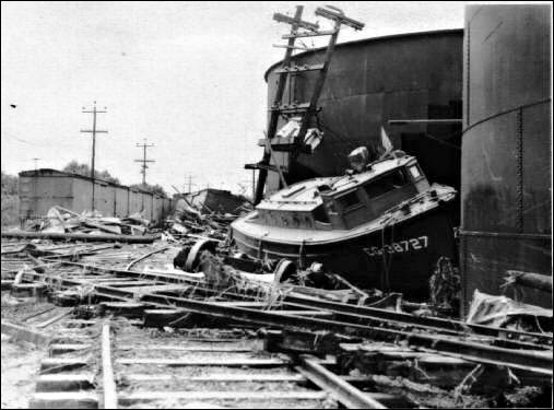
“It was quite a severe earthquake as I remember. Another scary thing that happened on Lanai was a tidal wave during the building of Kaumalapau Harbor.”

“They were building the breakwater and they had a small locomotive that with the tracks ran out to the end so they could carry boulders out to build up the breakwater.”

“And this tidal wave came and later, we went down to see what damage had been done. And the tracks were twisted in knots and the locomotive was on its side. Ever since then, I’ve been very frightened of tidal waves.”

“No one was injured; it was just this damage because no homes were knocked down where the harbor was. (The homes were built on higher ground, so they were not damaged.)”

No one was working at the time … “I believe that tidal wave came during the middle of the night at a time when there was nobody down there.” (Jean Forbes Adams; UH Oral History, Lanai Ranch)

© 2025 Ho‘okuleana LLC

Filed Under: Place Names, General Tagged With: Hawaii, Tsunami, Lanai

May 19, 2025 by Peter T Young Leave a Comment

Okino Hotel

“The [Okino] hotel [on Kamehameha Avenue] was built in 1913. But before then, [Yoshimatsu Okino] had another one on Front Street [Kamehameha], but I don’t know what year that was built. And then they built this big one in 1913.” (Violet Hirata)

Hotel advertising referred to it as “The Oldest Hotel in Hilo”. (Hilo Tribune Heald, July 31, 1947) A newspaper story referred to it as “the oldest Japanese hotel in Hilo”. (Hilo Tribune Herald, July 24, 1959)

Yoshimatsu Okino was born on December 4, 1860, in Hiroshima-ken, Japan. He had at least 2 sons and 1 daughter with Waka Hamai. (Family Search)) Yoshimatsu Okino died in 1917; after that, his son, Yoshio (‘Fats’) Okino took over the operation.

“We had all different customers. We used to have – month to month, we had salesmen that came from Honolulu, and different tenants. We had some boarders that worked in Hilo. So they boarded there and they went to work. So we had quite a few of them boarding, regular boarders.”

[Masako Kayano Okino], born in Pahala, married Yoshio Okino, son of the Okino hotel founder. Masako “was busy with the cooking and all that with the ladies.”

“And [we] had my aunt living with us when we were young to help my mom. So, besides the ladies that work with her, we had one aunt, older aunt that stayed, and then the younger one came in and stay, take over after that. We were lucky.”

“And they had [base]ball teams coming. Or, Fourth of July, they have [sumo] wrestlers coming in. The group comes and goes. We were very busy.”

“Grandfather built it. Grandfather died when [Yoshio] was nineteen, so [Yoshio] had to take over that. Grandma [Waka Okino] died later, but he was nineteen only when Grandfather died.”  (Violet Hirata, daughter of Yoshio Okino)

Yoshio Okino and Masako Kayano Okino owned and operated Okino Hotel on 482 Kamehameha Avenue. There were family quarters in one section of the hotel. The children helped their parents in the hotel dining room, serving food to customers and clearing tables.

Okino Hotel was destroyed in the 1946 tsunami. Hirata and the family managed to escape the waves by fleeing in back of the building – away from the ocean – toward the Hilo Gas Company gas tanks. Her brother, George, became trapped in the debris and was later rescued. A guest of the hotel died that day.

Yoshio later established another hotel on Kino‘ole Street, which they operated until 1959. Hirata eventually worked as a hairdresser, and later, for Western Auto. She retired in 1989. She and her husband, Takeshi Hiiata, whom she married in 1949, raised three children and currently have five grandchildren. (NOAA Fisheries)

“The Okino Hotel, which was completely demolished in the tidal wave of April 1, 1946, will reopen its modern, two story building Friday in a new location at 481 Kinoole street.” (Hilo Tribune Herald, July 31, 1947)

(“Ironically, the single remaining ‘monument’ from the 1946 tsunami, the furo bathroom of the old Okino hotel, stood firm through the … wave assault”. (Hilo Tribune Herald, July 18, 1960))

“Construction of the proposed Okino Hotel has been postponed indefinitely, Yoshio Okino reported today.  Instead, Okino has taken a lease on the two story building at 481 Kinoole Street … he said he cannot afford to wait any longer to get back into business”.  (Hilo Tribune Herald, June 16, 1947)

“The new structure is situated across from the Hilo fire department and will be under management of Yoshio Okino …. The hotel has been located in Hilo for over 50 years and prior to the tidal wave was on Kamehameha avenue.”

“Well-ventilated, the hotel will have 24 rooms for transient guests, and will have hot and cold showers. A restaurant will be located on the ground floor.”

“In his youth, [Yoshio] Okino was one of the most noted  baseball players in the territory, known as the ‘Babe Ruth of the Pacific.’  [He was referred to as the ‘home run king’ with a batting average of .556]”. (HTH)

“He was centerfielder of the Japanese Athletic club nine that toured Japan in the early ‘20s. Later he became a catcher. His sons are prospective Hilo senior leaguers.” (Hilo Tribune Herald, July 31, 1947)

Yoshio “started in Honolulu with the Japanese High school team there and played for the JAC combine in Hilo during his summer vacations. That was his start.”

“In 1916, he played football and baseball for the Mid-Pacific Institute, also known as Mills school. The following year he came to Hilo and started playing for the JAC in dead earnest.” (Hilo Tribune Herald, April 6, 1928)

Back to the hotel … a July 24, 1959 notice in the paper noted, “Okino Hotel will be closed from July 31, 1959. [Yoshio Okino stated,] I wish, at this time, to extend sincere thanks and appreciation to my many patrons and friends for their kind patronage in the past years. Retiring after 40 years in the Hotel Business.” (Hilo Tribune Herald) He then moved to Honolulu.

Shortly thereafter, a “Notice” in the paper, “Announcing the Change of Name and Ownership of Okino Hotel, Effective August 1st, 1959” to Lincoln Hotel. “Richard M Inouye, Owner of the Lincoln Grill)”.

Later, “The New Rainbow Hotel … Formerly Known as Okino Hotel” was “Completely Remodeled” “all with Private Bathrooms” and “Open for Business”. (Hawaii Tribune Herald, Dec 29, 1965).  The former Okino Hotel still stands across from the Fire Station on Kino‘ole street.

© 2025 Ho‘okuleana LLC

Filed Under: General, Buildings, Economy Tagged With: Hilo, Tsunami, Okino Hotel, Yoshimatsu Okino, Yoshio Okino, 1946 Tsunami

April 2, 2023 by Peter T Young Leave a Comment

Holoua

In historical times, two tsunamis occurred during the first week of April. The first of these occurred on April 2, 1868; it resulted from the great earthquake that took place that day near Pahala.

Based on the extent and type of damage, the 1868 earthquake is estimated to have had a magnitude of about 8.0. Reports indicate that 46 people were killed and several entire Hawaiian villages were destroyed by the tsunami generated from the earthquake. (USGS)

Destruction caused by the 1868 great Ka‘ū earthquake included the Wai‘ōhinu in the Ka‘ū District of Hawai‘i Island. With a magnitude estimated at 7.9, the earthquake is the largest in Hawai‘i’s recorded history. (USGS)

“There were twelve shocks counted during the night. -most of them easy, one however rocked the bed considerably At four oclock that afternoon there was such an awful rocking and heaving of the earth as we never felt before.”

“Indeed there was a series of shocks following each other in quick succession the third of which drove us from the house.”

“After a cessation of only one or two minutes the fourth came. in which violent undulations, rotary, and all most all other motions were combined or followed each other in quick succession. “

“At one moment the surface of the earth seemed to move like the surface of the ocean and the large trees to sway hither and thither like ships masts in a storm. The few stone buildings in the place were ruined.”

“The chimneys of cook and dwelling houses were thrown down. Clocks, mirrors and crockery, not firmly secured, were generally thrown down and broken. Cellar walls and underpinning were much damaged.”

“Stone walls were generally prostrated, even the foundation stones being generally removed from their original position. and it was not easy to tell in which direction from the wall the larger portion of the stones had fallen.”

“The best chimney stacks of the Hilo Sugar Mills were thrown down while some of the old cracked chimneys supposed all most ready to fall were little affected. The shocks were considerably more severe here than they were at the crater of Kilauea thirty miles from here, but less severe than they were in Kau from Kapapala to Kahuku.”

“Then slight jars were felt almost constantly for a few minutes after which the earth commenced rocking again fearfully. This continued but a short time and was followed by a tidal wave.”  (Sarah Lyman; USGS)

A letter “by the School Inspector-General [Abraham Fornander] gives a detailed account of the volcanic phenomenon on Hawaii” in the April 29, 1868 issue of the Hawaiian Gazette.

Fornander notes, “I have just been told an incident that occurred in Ninole, during the inundation of that place.  At the time of the shock on Thursday, a man named Holoua, and his wife, ran out of the house and started for the hills above, but remembering the money he had in the house, the man left his wife and returned to bring it away.”

“Just as he had entered the bouse the sea broke on the shore, and, enveloping the building, first washed it several yards inland, and then, as the wave receded, swept It off to sea, with him in it.”

“Being a powerful man, and one of the most expert swimmers in that region, he succeeded in wrenching off a board or a rafter, and with this as a papa hee-nalu, (surf board), be boldly struck out for the shore, and landed safely with the return wave.”

“When we consider the prodigious height of the breaker on which he rode to the shore, (50, perhaps 60, feet), the feat seems almost Incredible, were it not that be is now alive to attest it, as well as the people on the hillside who saw him.” (Fornander in Hawaiian Gazette, April 29, 1868)

Artist William CP Cathcart of Honolulu made a painting of the event and calls what Holoua did, ”the greatest aquatic feat of its kind in the history of the world”.

“Not many would quarrel with him that [Holoua], is the granddaddy of all surfriders.  [Holoua] happens to be riding the crest of a 50 to 60 foot tidal wave, using a house rafter for a surfboard.”

“Says Artist Cathcart: ‘[Holoua] prevailed, the undefeated super-champion of surfers …’ Mr Cathcart suggests the [Holoua’s] deed should be commemorated with a large bronze statue, suitably placed.  The deed itself, he says, merits ‘a tribute that would immortalize the prestige of Hawaii through centuries.’”

“Just to show what the water was like that day, the old Commercial Advertiser reported that four villages and 100 persons perished in the waves.” (Honolulu Advertiser, March 10, 1957)

An obituary for Holoua’s grandson, Joseph Kanuu Holoua, notes that the story “has been passed from generation to generation of Holouas. Aa Holoua used a house rafter for a surfboard and safely [rode] a 50 to 60-foot tidal wave to shore.” (Honolulu Advertiser, March 12, 1961)

The April 2 great Ka‘ū earthquake was part of a larger volcanic crisis that unfolded over 16 days. On March 27, an eruption quietly began in Moku‘āweoweo, the caldera at the summit of Mauna Loa.

Seismic activity increased through the day, and by the afternoon of March 28, a magnitude-7.0 earthquake occurred in Ka‘ū, which caused extensive damage from its own very strong to violent shaking.

During the following four days, nearly continuous ground shaking was reported in Ka‘ū and South Kona. Earthquakes continued at rates of 50 to 300 per day, including a magnitude-6.0 each day, leading up to April 2.

Then, the great Ka‘ū earthquake, 15 times stronger than the magnitude-7.0 foreshock, occurred at 4 pm. A severe aftershock occurred on April 4, and aftershocks of decreasing magnitudes continued for decades.

The great Ka‘ū earthquake unlocked Mauna Loa’s Southwest Rift Zone, and on April 7, 1868, an eruptive fissure opened low on the mountain, just above today’s Highway 11 and east of Hawaiian Ocean View Estates. (USGS) (The other April tsunami was April 1, 1946.)

© 2023 Ho‘okuleana LLC

Filed Under: General, Prominent People Tagged With: Holoua, Tsunami, Surfing, Earthquake

February 10, 2023 by Peter T Young Leave a Comment

Tsunami in Hawai‘i

A tsunami is a series of ocean waves generated by sudden displacements in the sea floor, landslides or volcanic activity.  In the deep ocean, the tsunami wave may only be a few inches high.  The tsunami wave may come gently ashore or may increase in height to become a fast moving wall of turbulent water several meters high.
 
In Hawaii, tsunamis have accounted for more lost lives than the total of all other local disasters.  In the 20th century, an estimated 221 people have been killed by tsunamis.  Most of these deaths occurred on the Big Island during the tsunamis of 1946 and 1960, two of the largest tsunamis to strike in the Pacific.
 
Here is a brief summary of some recent tsunami and their impacts in Hawai‘i:
 
1946
The tsunami of 1946 was generated by a magnitude 7.1 earthquake in the Aleutian Islands.  This tsunami struck the Big Island of Hawaii on April 1st.  The tsunami flooded the downtown area of Hilo killing 159 people and causing more than $26-million in damages.
 
1952
On November 4, 1952 a tsunami was generated by a magnitude 8.2 earthquake on the Kamchatka Peninsula in the USSR.  In Hawaii, property damage from these waves was estimated at $800,000-$1,000,000 (1952 dollars); no lives were lost.  The waves beached boats, caused houses to collide, destroyed piers, scoured beaches and moved road pavement.
 
1957
On March 9, 1957 a tsunami was generated by a magnitude 8.3 earthquake in the Aleutian Islands.  It generated a 24-foot tsunami that did great damage on Adak Island, especially to the fuel and oil docks.  The Hawaiian Islands incurred about $5,000,000 of damage in 1957 dollars.  The highest wave in Hawaii was 12-feet.
 
1960
The tsunami of May 23, 1960 was generated by a magnitude 8.3 earthquake in Chile.  The 35-foot tsunami struck Hilo, Hawaii causing severe damage.  61-deaths were recorded and $23-million in damage occurred.  In the area of maximum destruction, only buildings of reinforced concrete or structural steel and a few others sheltered by these buildings, remained standing – and even these were generally gutted.  Frame buildings were either crushed or floated nearly to the limits of the flooding.
 
1975
On November 29, 1975, an earthquake occurred off the coast of the Big Island of Hawaii.  When the quake-generated tsunami struck, 32 campers were at Halape Beach Park.  The sound of falling rocks from a nearby cliff, along with earth movement caused the campers to flee toward the ocean.  They were then forced back to the cliff by rising ocean waters.  The first wave was 5-feet high, but the second wave was 26-feet high and carried the unfortunate campers into a ditch near the base of the cliff, where they remained until the ordeal ended.  Two campers died and 19 suffered injuries.
 
2011
An earthquake measured at 9.0 magnitude, the sixth biggest since 1900, struck Japan on March 11, 2011.  The first tsunami waves reached Kaua‘i shortly after 3 a.m. and took about 30 minutes to sweep through the island chain.  Waves above 6-feet were recorded at Kahului on Maui and 3-feet at Haleiwa on the north shore of Oahu.  Lost homes, sunken boats, Kona Village Resort damage, and damaged piers and roads caused tsunami damage into the tens of millions of dollars; no one was killed or injured during the tsunami.
 
The earliest historical account of a Hawaii tsunami was from a 16th century Hawaiian chant that described a huge wave that struck the coast of Molokai.
 
The earliest confirmed tsunami was on Dec 21, 1812, when a wave from Southern California was observed at Ho‘okena on the west coast of the Big Island (Hawai‘i island). Maximum runups in excess of 15 m were measured for the 1946 and 1957 distant tsunamis and the 1975 local tsunami.
 
The record shows that damaging tsunamis from distant earthquakes reached Hawaii these years: 1837, 1841, 1868, 1869, 1877, 1883, 1906, 1918, 1923, 1933, 1946, 1957, and 1960. Other smaller tsunamis that caused no significant damage in Hawaii were generated by distant earthquakes in 1896, 1901, 1906, 1919, 1922, 1923, two in 1927, 1928, 1929, 1931, 1938, 1944, 1952, and 1964.
 
In a period of 157 years, a damaging or destructive tsunami struck the Hawaiian Islands on the average of once in every twelve years.
 
© 2023 Ho‘okuleana LLC

Filed Under: General Tagged With: Hawaii, Hilo, Tsunami, Kailua-Kona

April 2, 2022 by Peter T Young 1 Comment

Largest Earthquake in Hawaiʻi

Magnitude 7.9, Kaʻū, Island of Hawaiʻi, April 2, 1868

On March 27, 1868, whaling ships at Kawaihae on the west coast of Hawaiʻi observed dense clouds of smoke rising from Mauna Loa’s crater, Mokuʻāweoweo, to a height of several miles and reflecting the bright light from the lava pit.

Slight shocks were felt at Kona on the west coast and Kaʻū on the flanks of the volcano.

On the 28th, lava broke out on the southwest flank and created a 15-mile flow to the sea. Over 300 strong shocks were felt at Kaʻū and 50 to 60 were felt at Kona.

At Kilauea, the surface of the ground quivered for days with frequent vigorous shocks that caused lamps, crockery and chairs to spin around as if animated.

One shock resembled that of a cannon projectile striking the ground under the proprietor’s bed, causing him to flee, according to the narrative published by C. H. Hitchcock in the Bulletin of the Seismological Society of America in 1912.

Between March 28, 1868 and April 11, over 2,000 distinct shocks were felt at Kona.

The main shocks struck on April 2, at 4:00 p.m., and again on April 4 at 12:30 a.m., the epicenter was located near Waiohinu.

“Thursday, April 2d, at a few minutes past four, p.m., the big earthquake occurred, which caused the ground around Kilauea to rock like a ship at sea. At that moment, there commenced fearful detonations in the crater, large quantities of lava were thrown up to a great height; portions of the wall tumbled in.”

“This extraordinary commotion, accompanied with unearthly noise and ceaseless swaying of the ground continued from that day till Sunday night, April 5th”. (Hawaiian Gazette, May 6, 1868)

A magnitude of 7 ¾ was estimated for this earthquake (by Augustine Furumoto in his February 1966 article on the Seismicity of Hawaii in the Bulletin of the Seismological Society of America) based on the extent of intensity reports.  (Instrumental recordings, the usual basis for computing magnitudes, were not available at this early date.)

The shock was felt throughout the islands, as far as Niʻihau about 350 miles away.

The ground rolled like a ship at sea and many walls tumbled down.

A landslide three miles long and thirty feet thick swept down the hill carrying trees, animals, and men.  Thirty-one people and thousands of cattle, sheep, horses and goats were killed in the one slide.

A tsunami struck the coast from Hilo to South Cape, being most destructive at Keauhou, Puna and Honuʻapo; 180 houses were washed away and 62 lives were lost to the wave alone.

A 10-foot-high wave carried wreckage inland 800-feet. Not a house survived at Honuʻapo. A stone church and other buildings were destroyed at Punaluʻu.

Maximum wave heights were 65 feet, the highest observed on Hawaiʻi to date.

At Keauhou (now Keauhou Landing) the water rose 35-50-feet destroying all the houses and warehouses and drowning 46 people. At Hilo, the height of the wave was about 10-feet, and at Kealakekua, 6-feet. The tsunami also was observed on Maui and Oʻahu. Also felt on Lānaʻi, Maui, Oʻahu, and Kauaʻi.

“The tidal wave was much greater than before stated. It rolled in over the tops of the cocoanut trees, probably sixty feet high, and drove the floating rubbish, timber, etc., inland a distance of a quarter of a mile in some places, taking out to sea when it returned, houses, men, women, and almost everything movable. The villages Punaluu, Ninole, Kawaa and Honuapo were utterly annihilated.”  (American Journal of Science, 1868)

This major earthquake caused 77 deaths (tsunami, 46; landslide, 31).

It knocked almost all wooden houses off their foundations in the Keiawa, Punaluʻu and Nīnole areas. In those areas, straw houses supported by posts in the ground reportedly were “torn to shreds.”

At Kaʻū, the more substantial houses and every stone wall were thrown down.

At Waiʻōhinu, a large stone church collapsed within 10 seconds of the onset of shaking. The shock “ruined” the few stone buildings in Hilo and shook down almost every wall. Brooks became muddy.

At Kealakekua, strong trees were bent backward and forward “like reeds in a storm.” Ground waves as much as 2-feet from ground to crest were observed at Kohala.

The motion was so violent at ʻUlupalakua that it was difficult for people to stand. Reports from Keaiwa and Kiolakaʻa suggest that vertical accelerations larger than 1g may have occurred (which means that the force of the earth pushing up on something is stronger than the force of gravity keeping it on the ground.)

Extensive surface effects were observed in the epicentral region. Ground fissures extended from Pahala to Kilauea. At Kahuku, a fissure about 5 kilometers long was reported. A volcanic eruption took place from that fissure a few days later, on April 7.

Along the Puna coast, the land subsided in places as much as 6-feet. At Kaimū, trees stood about 8-feet deep in sand and water. The plain at Kalapana sank about 6-feet, and water stood as much as 5-feet deep over 20 acres of formerly dry land.

Much of the information here is from USGS, with some noted from the diary and letters of Mrs. Sarah J. Lyman, wife of missionary David Layman in Hilo.

© 2022 Hoʻokuleana LLC

Largest Earthquake in Hawaiʻi - Magnitude 7.9, Kaʻū, Island of Hawaiʻi, April 2, 1868-400
Largest Earthquake in Hawaiʻi - Machado
Largest Earthquake in Hawaiʻi – Machado

Filed Under: General Tagged With: Earthquake, Hawaii, Tsunami

  • 1
  • 2
  • Next Page »

Images of Old Hawaiʻi

People, places, and events in Hawaiʻi’s past come alive through text and media in “Images of Old Hawaiʻi.” These posts are informal historic summaries presented for personal, non-commercial, and educational purposes.

Info@Hookuleana.com

Connect with Us

  • Email
  • Facebook
  • LinkedIn
  • Twitter
  • YouTube

Recent Posts

  • About 250 Years Ago … Battles of Saratoga
  • Spanish Lake
  • New Wives, New Mothers
  • Water Crisis
  • Waiʻanapanapa
  • 250 Years Ago – George Washington Address to the Inhabitants of Canada
  • Elmer Ellsworth Conant

Categories

  • Voyage of the Thaddeus
  • Mayflower Summaries
  • American Revolution
  • General
  • Ali'i / Chiefs / Governance
  • Buildings
  • Missionaries / Churches / Religious Buildings
  • Hawaiian Traditions
  • Military
  • Place Names
  • Prominent People
  • Schools
  • Sailing, Shipping & Shipwrecks
  • Economy

Tags

Albatross Al Capone Ane Keohokalole Archibald Campbell Bernice Pauahi Bishop Charles Reed Bishop Downtown Honolulu Eruption Founder's Day George Patton Great Wall of Kuakini Green Sea Turtle Hawaii Hawaii Island Hermes Hilo Holoikauaua Honolulu Isaac Davis James Robinson Kamae Kamaeokalani Kamanawa Kameeiamoku Kamehameha Schools Lalani Village Lava Flow Lelia Byrd Liliuokalani Mao Math Mauna Loa Midway Monk Seal Northwestern Hawaiian Islands Oahu Papahanaumokuakea Marine National Monument Pearl Pualani Mossman Queen Liliuokalani Thomas Jaggar Volcano Waikiki Wake Wisdom

Hoʻokuleana LLC

Hoʻokuleana LLC is a Planning and Consulting firm assisting property owners with Land Use Planning efforts, including Environmental Review, Entitlement Process, Permitting, Community Outreach, etc. We are uniquely positioned to assist you in a variety of needs.

Info@Hookuleana.com

Copyright © 2012-2024 Peter T Young, Hoʻokuleana LLC


Loading Comments...