Images of Old Hawaiʻi

  • Home
  • About
  • Categories
    • Ali’i / Chiefs / Governance
    • American Protestant Mission
    • Buildings
    • Collections
    • Economy
    • Missionaries / Churches / Religious Buildings
    • General
    • Hawaiian Traditions
    • Other Summaries
    • Mayflower Summaries
    • Mayflower Full Summaries
    • Military
    • Place Names
    • Prominent People
    • Schools
    • Sailing, Shipping & Shipwrecks
    • Voyage of the Thaddeus
  • Collections
  • Contact
  • Follow

June 19, 2022 by Peter T Young Leave a Comment

Hickam

The first successful air flight was in a hot air balloon in 1783; since heated air is lighter than cool air, the balloon would rise into the sky. The pilot would ride in a basket attached to the balloon and control the height by adding and subtracting more heat.

The problem with hot air balloons is that you cannot go the way you want. If the wind is blowing west, that means you would have to go west, too.

Flight took a new turn with the invention of the airplane in 1903; the military quickly became aware of its use in combat. “It can go faster and higher than horses,” said one Army aviator. The US War Department bought its first plane in 1909 and it was assigned to the new Army Air Corps.

It wasn’t until the National Security Act of 1947 became law on July 26, 1947 that a separate, independent Department of the Air Force was created, headed by a Secretary of the Air Force.

In Hawaiʻi, the US Army built Luke Field on Ford Island (constructed in 1917;) by 1928, they recognized the benefit of an expanded air presence, including in Hawaiʻi, and they began looking for a new site for modernizing the national defenses here.

Site selection narrowed to about 2,200-acres of land bordered by Pearl Harbor channel on the west, Pearl Harbor Naval Reservation on the north, John Rodgers airport on the east and Fort Kamehameha on the south.

The land was acquired from Bishop, Damon and Queen Emma Estates and on May 31, 1935 Hickam Air Field was dedicated (it was named in honor of Lt. Col. Horace Meek Hickam, a distinguished aviation pioneer who was killed in an aircraft accident on November 5, 1934, at Fort Crockett in Galveston, Texas).

In naming boulevards and avenues on Hickam Field, the War Department deemed it appropriate to remember those early aviation pioneers who were killed in the Hawaiian Islands as a result of airplane accidents: Fox Blvd. -1st Lt. Robert E. Fox, killed 1920; Cornet Ave. -Pvt. Harman J. Cornet, 1920; Boquet Blvd. -1st Lt. Ulric L Boquet, 1921; Manzelman Circle -1st Lt. Earle R Manzelman, 1921; Vickers Ave. -SSgt. Vernon Vickers, 1921; Owens St. -Sgt. Ross Owens, 1922; Julian Ave. -1st Lt. Rupert Julian, 1923; Monthan St. -1st Lt. Oscar Monthan, 1924; Moore St. -1st Lt. William G. Moore, 1924; Catlett St. -2nd Lt Carter Catlett, 1925; Porter Ave. -TSgt. Aaron A. Porter, 1925; Worthington Ave. -1st Lt. Robert S. Worthington, 1927; Signer Blvd. -Capt. John A Signer, 1927; Kuntz Ave. -1st Lt Clyde A. Kuntz, 1929; Atterbury Circle -2nd Lt. Ivan M. Atterbury, 1930; Mills Blvd. -SSgt. Ralph O. Mills, 1930; Scott Circle -2nd Lt William J. Scott, 1931; Baker St. -2nd Lt. George C. Baker, 1931; Wilson St. -Pfc Hicks G. Wilson, 1935 and Beard Ave. -1st Lt. William G. Beard, 1936.

Hickam Field, as it was then known, was completed and officially activated on September 15, 1938. It was the principal Army airfield in Hawaiʻi.

By the end of 1939, the Air Corps organization located at Hickam Field were, Headquarters, 18th Wing; 5th Bombardment Group; Headquarters Squadron, 5th Bombardment Group; 23rd Bombardment Squadron; 31st Bombardment Squadron; 72nd Bombardment Squadron; 4th Reconnaissance Squadron and 17th Air Base Commando (shortly after, the 11th Bombardment Group was included.

In connection with defense plans for the Pacific, aircraft were brought to Hawaii throughout 1941 to prepare for potential hostilities.  The only airfield large enough to accommodate the B-17 bomber (the Flying Fortress, at the time, the Air Corps’ most-modern airplane,) in May 1941, Hickam received the first mass flight of bombers (21 B-17s) from Hamilton Field, California.

When the Japanese attacked Oahu’s military installations on December 7, 1941, Hickam Field was an important objective; because the success of the Japanese attack was dependent on eliminating air opposition and precluding US planes from following their aircraft back to their carriers and bombing the task force.  Hickam suffered extensive damage, about half of its planes had been destroyed or severely damaged, and personnel casualties totaling 139 killed and 303 wounded.

During the war years, the base played a major role in pilot training and aircraft assembly work, in addition to serving as a supply center for both air and ground troops. Hickam served as the hub of the Pacific aerial network, supporting transient aircraft ferrying troops and supplies to, and evacuating wounded from, the forward areas.

On March 26, 1948, Hickam Field was renamed Hickam Air Force base.   After World War II, Hickam was the US primary mobility hub in the Pacific comprised of the Air Transport Command and its successor, the Military Air Transport Service, until July 1957 when Headquarters Far East Air Forces completed its move from Japan to Hawaiʻi and was redesignated the Pacific Air Forces.

Hickam Air Force Base supported the Apollo astronauts in the 1960s and 1970s; Operation Homecoming (return of prisoners of war from Vietnam) in 1973; Operation Babylift/New Life (movement of nearly 94,000 orphans, refugees and evacuees from Southeast Asia) in 1975; and NASA’s space shuttle flights during the 1980s and into the 1990s.

The 2005 Defense Base Closure and Realignment Commission (BRAC) Report to the President combined the once-independent Pearl Harbor Naval Station (Navy) and Hickam Air Force Base (Air Force) management functions with the establishment of Joint Base Pearl Harbor-Hickam (effective October 1, 2010.)

Hickam now consists of 2,850 acres of land and facilities sharing its runways with the adjacent Honolulu International Airport as a single airport complex, operated under a joint-use agreement.

In October 1980, the Secretary of the Interior designated Hickam AFB as a National Historic Landmark, recognizing it as one of the nation’s most significant historic resources associated with World War II in the Pacific. A bronze plaque reflecting Hickam’s “national significance in commemorating the history of the United States of America” took its place among other memorials surrounding the base flagpole. (Lots of information here is from NPS and ‘Hickam’)

© 2022 Hoʻokuleana LLC

Filed Under: Military Tagged With: Pearl Harbor, Hickam, Joint-Base Pearl Harbor-Hickam, Hawaii, Oahu

May 20, 2022 by Peter T Young Leave a Comment

The Call of the Sea

“It began in the swimming pool at Glen Ellen. Between swims it was our wont to come out and lie in the sand and let our skins breathe the warm air and soak in the sunshine. Roscoe was a yachtsman. I had followed the sea a bit. It was inevitable that we should talk about boats.”  (London)

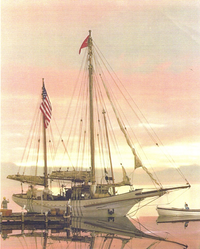
In 1906, Jack London announced he was planning a trip on a boat – the Snark – he was to build and do blue-water sailing on a round-the-world cruise.  (The Snark was named after one of Lewis Carroll’s nonsense poems.)

“‘Honolulu first,’ said London yesterday. ‘After that we are not very definite. Everybody’s in good health, the bourgeoise tradesmen have finally freed us, the boat is staunch, the weather fine. What more a man wants I don’t know.’”

“‘Meet me in Paris,’ called Mrs. Jack London back through the megaphone as the boat disappeared. ‘Isn’t it glorious? Good-by, everybody!” [April 23, 1907]

“The remaining members of the crew of the Snark are: Captain Rosco Eames, under whose personal direction the Snark was built; Herbert Stoitz of Stanford University; Martin Johnson, cook, and Hideshisa Hochigi. Cabin boy.”

“Flying from her mainmast the red flag of Socialism, Jack London’s Snark, towed by a gasoline launch, passed through the Oakland estuary shortly after noon yesterday.”

“She had been freed from Federal surveillance and scores of the author’s friends thronged her deck as she lay at Franklin-street wharf to bid godspeed to him and his wife on their long cruise.”

“Cheer after cheer rent the air as the Snark moved down the channel and passed out into the bay, on her way to Bonita Cove, near Sausalito, where she will await the ebb tide this morning before sailing through the Golden Gate.”

“In the farewell levee on the deck leaders in Socialism hobnobbed with literary workers and a staid burgher friend or two mingled in the gathering with men of the professions. But for the most part the throng that gathered was made up of workingmen as negligee in attire as the author himself.”

“They all called him ‘Jack,’ and he seemed to know them all. They cheered when the two banners of red, the one bearing the initial S. for Snark and Socialism: the other, a black and white star, the London emblem,” were hauled by Captain Eames to the masthead.”

“There they will fly until the cruise is done, carrying the message of Socialism to the people of the seven seas.”  (PCA, April 30, 1907)

“The arrival of Mr. Jack London in the Snark is looked forward to with pleasant anticipation by certain society folk who will doubtless wine and dine him most hospitably.”

“After many rumored departures, he is said to have really sailed from San Francisco and may be expected here shortly, wind, weather and his navigating officer permitting.” (PCA, April 28, 1907)

“Folks flocked down to the waterfront to get a glimpse of the little craft which was designed to circumnavigate the globe.”

“A glimpse was all they got, for the Snark gave a line to Young Brothers’ tug Waterwitch and was towed to Pearl Harbor, where she dropped anchor off the Hobron place, and will probably remain there for the best part of the next two months.”

“Mr and Mrs London made up their respective and collective minds to spend at least two months in the waters of Pearl Lochs and to take their residence ashore in the TW Hobron cottage.  They yearn for the shore awhile and want to be quite.”

“‘We are here for work,’ said Mrs London when the Londons were visited by a representative of the Star shortly after their arrival here at 11:20 o’clock this morning [May 20, 1907]. Continuing Mrs. London stated that her husband intended to put in a lot of time writing and that they could not Image a quieter place than Pearl Lochs.”

“They will not go to Honolulu today. They do not want the distractions of the city, preferring, for the present at least, the peacefulness of the Hobron cottage, whither the typewriter has already been transferred from the cabin of the Snark and where

its click will be heard until late in July.”

London noted, “‘Pearl Harbor is a dream. The coming through the breakers into the placid water of the lagoon is a sight I shall never forget.  We shall remain here and work as quietly as may be.  I’m sick of the hotels and steamships.’”

“There are years of adventure and romance before the people of the Snark and the beginning has been auspicious. The Snark has proved herself to be everything that London claimed she would be.”

“‘We’ve come 2600 miles In twenty-seven days,’ said the captain, ‘and while not tired of the trip must say that land looks mighty good to me.  We went south in order to fall in with the dolphins and flying fish and latterly bore southwest for the wind as far as the nineteenth longitudinal.’”

“‘We loafed along the whole way, with more wind the first four days out than we had all the rest of the trip. The voyage was singularly devoid of Incident.  Three days out a ship was sighted, after which nothing was seen till Sunday, when we saw a steamer hull down.’

“The Snark is thirty tons gross and ten tons net; fifty-one feet in length, fifteen and five-tenths beam and seven and fieve-tenths in depth of hold.  Her foremast is much taller than the main and she carries a big bowsprit.  Her deck is flush and living apartments occupy the whole vessel from stem to stern.”

“The Snark, according to present plans, will leave here in about twenty days for Hilo. From Hilo the South Seas, Australasia and the Orient, and the rest of the world, will be checked off the Snark’s chart.” (Hawaiian Gazette, May 21, 1907)

Charmian London (Mrs Jack London) made a couple of books about the two years’ with her husband in the forty-five-foot ketch Snark into the South Seas, by way of the Hawaiian Islands.

The seafaring portion of her notes was published in 1915 as “The Log of the Snark.” The record of five months spent in the Paradise of the Pacific, Hawaii, she made into another book, “Our Hawaii,” issued in 1917. Jack London had previously passed through Honolulu in 1893.

The South Sea trip was meant to be just the beginning of the cruise. London dreamt of threading the Arabian Sea and traversing the Mediterranean and the Atlantic but ultimately it was the savage climate of the south Pacific that did for him.

After about 2-years of sailing, at Guadalcanal in the Solomon Islands London became afflicted by a skin disease which meant his hands swelled up and chunks of skin fell off. Without his hands he could not write and earn the money to fund the voyage and, after seeking medical advice, he was urged to abandon the trip.

It was a devastating decision for London, and he and Charmian were distraught, as Jack recalled: “In hospital when I broke the news to Charmian that I must go back to California the tears welled into her eyes.”

“For two days she was wrecked and broken by the knowledge that the happy, happy voyage was abandoned.”  Thus one of the most offbeat and pioneering cruises ended rather abruptly.  Once the voyage was called off, Snark was sailed to Sydney and sold there.  (Jefferson) 

© 2022 Ho‘okuleana LLC

Filed Under: Prominent People, Sailing, Shipping & Shipwrecks Tagged With: Hawaii, Pearl Harbor, Jack London, Sailing, Charmian London, Snark

May 17, 2022 by Peter T Young Leave a Comment

Lord Byron’s 1825 Trip to Pearl River

In 1824, Liholiho (King Kamehameha II), his wife, Kamāmalu, and a group of retainers and foreign advisors, traveled from Hawai‘i to England. Liholiho and his wife died in England and in May of 1825, their bodies were returned to Hawai‘i by Lord Byron.

While in the islands, James Macrae, a botanist, traveling with the Lord, traveled to various locations in the company of native guides, where he took observations and collected biological samples.

One of Macrae’s journeys along with Lord Byron and party took him to Pu‘uloa, the Pearl River, where he described the scene and scenery. (Maly)

“May 17. Joined Lord Byron’s party, with Mantle carrying my traps. We did not embark until noon. After two hours sailing along the coast, we entered the mouth of the Pearl River, which divides itself into several branches, forming two islands.”

“One which is smaller than the other is called Rabbit island [Moku‘ume‘ume], from a person, the name of Marine [Marin], a Spaniard, residing at Hanarura, having put rabbits on it some years ago. The rabbits have since increased in numbers.”

“It became so calm, that his Lordship, Mr. C., and the Bloxoms left us in the launch, and rowed in the small boat in tow, and soon disappeared from sight.”

“We waited in suspense, hour after hour, not knowing the several branches of the river, nor where we were to spend the night.”

“The boat party pulling into one branch of the river, the other in which I was tacking about from bank to bank till the boaters hauled their boat ashore and we cast anchor.”

“Both parties were opposite each other on Rabbit Island, but ignorant of the fact, till on walking about the island, the parties met.”

“One hut was noticed, and those on the island made for it, but the launch having the ladies and some others on board, got up anchor and sailed round to the hut, where with the help of canoes, they all landed.”

“The ladies were somewhat discontented, but after a good dinner partaken sitting on mats spread on the grass, harmony was restored.”

“At dusk we embarked to cross to a larger hut. Landed at 8 p.m. At ten o’clock two old men entered our hut to play the hura dance on a couple of bottle shaped gourds. They took a sitting posture, beating time on the gourd’s with the palms of their hands, accompanied by a song made up about the late king.”

“About 11, we all retired to rest, lying down beside each other on mats, some with pumpkins or what else they could get for a pillow. The ladies got themselves screened off in a corner with a flag without any other accommodation.”

“Pearl River is about seven miles west of Hanarura, and is improperly called a river, being rather inlets from the sea, branching off in different directions. There are three chief branches, named by the surveyors, the East, Middle and West Lochs.”

“The entrance to Pearl River is very narrow and shallow, and in its present state it is fit for very small vessels to enter, but over the bar there is deep water, and in the channel leading to the lochs there are from 7 to 20 fathoms. The lochs themselves are rather shallow.”

“The coast from Hanarura to the west of Pearl River possesses no variety of plants beyond two or three species, such as Argemones (kala, beach poppy), Portulacas (‘ihi, yellow purslane), and a few other little annuals, intermixed with the common long grass so plentiful everywhere on the coast round the island.”

“The oysters that are found in Pearl River are small and insipid and of no value or consequence.”

“May 18. Got up at 4 a.m., after a restless night, having been tormented with fleas. Departed with my man Mantle, leaving the rest yet asleep. But after travelling about three miles, the path which we had first struck terminated, and the grass became longer and more difficult to travel over.”

“At last, after another three miles, we got so entangled with creeping plants running a little above the ground beneath the grass, that Mantle, who was stockingless, shed tears, complaining of his ankles, and refused to go on.”

“Being yet five miles from the woods, and not having sufficient provisions for two days, we were forced to return to the town by a path leading through taro ponds, some distance inland from the coast.”

“On the path we had left near the Pearl River, we saw several thickly inhabited huts, situated on the side of a ravine stocked with bananas, taro and healthy breadfruit trees just forming their fruit. Here we met with an old Englishman, who told us there was on the opposite side of the ravine a large river coming out under the ground.”

“We went to the place and found that what he had told us was correct, and stood admiring the subterranean stream of fine, cool water. Its source was rapid, forming a cascade nearly 20 feet in height, having ferns and mosses on its sides.”

“In the grounds of the natives, I saw plenty of the awa plant (piper) mentioned in the history of these islands, as being destructive to the health of the natives when used to excess, owing to its intoxicating qualities. I obtained several specimens of it in flower.”

“The old man informed me that he had been on the island over sixteen years, and that the grounds we were then upon, belonged to Boki, and had been in his charge for ten years.”

“Upon Boki going to England with the king, another chief had turned him away, and taken all his little ground from him, so that he had been forced to live on the charity of the natives.”

“The neighbourhood of the Pearl River is very extensive, rising backwards with a gentle slope towards the woods, but is without cultivation, except round the outskirts to about half a mile from the water.”

“The country is divided into separate farms or allotments belonging to the chiefs, and enclosed with walls from four to six feet high, made of a mixture of mud and stone.”

“The poorer natives live on these farms, also a few ragged foreigners who have a hut with a small spot of ground given them, for which they must work for the chiefs a certain number of days besides paying an annual rent in dogs, hogs, goats, poultry and tapa cloths, which they have to carry to whatever spot their master is then living on the island.”

“On the least neglect to perform these demands, they are turned away and deprived of whatever stock, etc., they may possess. Such is the present despotic or absolute law in the Sandwich Islands.”

“This is corroborated by all foreigners met with at different times, who, on our arrival, hoped that Lord Byron would render them their little property more secure in future. Unfortunately they must wait till the British Consul helps them, as we have no authority to interfere with the laws of the country.”

“On our way home we noticed that the country on the side towards the woods still remained uncultivated, also towards the sea coast, except the lower ends of the small valleys which are cultivated with the taro in ponds, which much resemble peat mosses that had been worked and afterwards allowed to get full of stagnant water.”

“There is no convenient road to travel anywhere on the island. We met with another subterranean river at the side of one of the hollows, larger than the other, but of no great fall after its appearance from underground.”

“By 4 pm we gained the summit of a high hill, thickly covered with tufts of long grass. It lies within three miles of Hanarura. There is a burying ground of the natives at the top, which was formerly where the chiefs of high rank had a morai.”

“At the bottom towards the sea, there is a circular salt pond, nearly two miles in circumference, surrounded by low conical hills. In places on the sides of a valley leading to the pond from the interior, are several huts of the natives with taro ponds and a large grove of coco-nut trees, apparently very old from their height and mossy appearance.”

“We reached town about six o’clock having travelled twenty miles since morning without much success, being too near the coast to meet with a variety of plants. We learnt, however, a good deal about the present mode of life of the natives, and the manner in which they continue to cultivate their grounds, differing but little, if any, from the descriptions given Capt. Cook and others.” (Macrae)

© 2022 Hoʻokuleana LLC

Honolulu-South_Shore-Pearl_Harbor-to-Diamond_Head-Kotzebue-1817-portion-for_GoogleEarth-600
Pearl_Lochs_and_Puuloa_Entrance-Map-1873
Puuloa-map
Puuloa-map
Pearl_Harbor,_Hawaii-2009
Puʻuloa_in_the_1880s
Ewa_ahupuaa

Filed Under: General, Ali'i / Chiefs / Governance, Place Names Tagged With: Lord Byron, Hawaii, Pearl Harbor, Ewa, Puuloa, Pearl River

May 8, 2022 by Peter T Young Leave a Comment

Secret Mission on the Strategic Potential

In June 1872, Secretary of War William Belknap gave US Army Major-General John McAllister Schofield confidential instructions to investigate the strategic potential of having a presence in the Hawaiian Islands, and to examine its ports.

They “ascertained the defensive capabilities of their different ports, examined into their commercial facilities, and collected all the information in our power on other subjects in reference to which we ought to be informed in the event of a war with a powerful maritime nation”.

Schofield and Brevet Brig. Gen. BS Alexander left San Francisco on December 30, 1872 aboard the USS California and arrived in Honolulu on January 15, 1873. After having an audience with new King Lunalilo, the men examined the islands.

In Schofield and Alexander’s May 8, 1873 report, they found that, “There are many other so-called harbors, or places for anchorage, but they are mostly open roadsteads affording shelter only from certain winds, and they are all entirely incapable of being defended by shore batteries.”

“Even the harbor of Honolulu itself can not be defended from the shore. It is a small harbor lying seaward from the land and only protected from the sea by outlying coral reefs. “

“An enemy could take up his position outside of the entrance to the harbor and command the entire anchorage, as well as the town of Honolulu itself. This harbor would therefore be of no use to us as a harbor of refuge in a war with a powerful maritime nation.”

“With one exception there is no harbor on the islands that can be made to satisfy all the conditions necessary for a harbor of refuge in time of war.”

“This is the harbor of ‘Ewa,’ or ‘Pearl River,’ situated on the island of Oahu, about 7 miles west of Honolulu.” They went on to recommend that the US obtain a cession of Pearl Harbor, together with its shore for four miles back.

“From our examinations we are of the opinion that this island and the adjacent shore to the north and west of it afford the most advantageous location for a naval depot of supplies and equipment in all these waters. But there is not sufficient water at present for heavy vessels to enter this Pearl River harbor.”

“At the entrance to the harbor is a coral reef some 250 to 300 yards in width, with a depth of water of only 2 to 3 fathoms on the reef at low water.”

“This reef appears to extend around the island, being broken only at the entrance to Honolulu Harbor, and in fact we are informed that a platform of coral reefs fringe most of the shores of all the islands of the Hawaiian group, broken only in few places. “

“This coral found at the entrance to Pearl River is ‘dead;’ that is, it is not growing, and the reef is therefore not increasing in size. This ridge of coral forms a barrier or bar across the entrance to this harbor about 300 yards wide, measuring perpendicularly to the shore.”

“It is comparatively level on the top, from 2 to 3 fathoms of water over it at low tide. Its sides are vertical, or nearly so, the depth of water increasing in a few feet to 4 or 5 fathoms.”

“The outer, or sea side, then is found to be steeper than the inner, or shore side. At the distance of half a mile outside of the reef there is a depth of 15 fathoms, while at the same distance inside the reef the depth is only 8 fathoms.”

“If this coral barrier were removed Pearl River Harbor would seem to have all or nearly all the necessary properties to enable it to be converted into a good harbor of refuge.”

“It could be completely defended by inexpensive batteries on either or both shores, firing across a narrow channel of entrance. Its waters are deep enough for the largest vessels of war, and its ‘locks,’ particularly around Rabbit Island, are spacious enough for a large number of vessels to ride at anchor in perfect security against all storms.”

“Its shores are suitable for building proper establishments for sheltering the necessary supplies for a naval establishment, such as magazines of ammunition, provisions, coral, spars, rigging, etc., while the island of Oahu, upon which it is situated, could furnish fresh provisions, meats, fruits, and vegetables in large quantities.”

The report noted that while eager to open a free market for their sugar, the Hawaiian government and native Hawaiians were not interested in the US annexing the islands at that time.

They stated, “The cession of Pearl River could probably be obtained by the United States in consideration of the repeal of the duty on Sandwich Island sugar.”

“Indeed, the sugar-planters are so anxious for a reciprocity treaty, or so anxious rather for free trade in sugar with the United States, that many of them openly proclaim themselves in favor of annexation of these islands to the United States.”

“The members of the present Government of the Hawaiian Islands seem fully alive to the necessity of relieving their principal industry from the heavy burden under which it now suffers, and no other mode of relief seems possible but annexation or reciprocity.” (Schofield and Alexander, 1873)

In February 1873 the Honolulu Chamber of Commerce, representing the interests of the plantation owners among the Islands, petitioned King Lunalilo to negotiate a reciprocal treaty with the US mainland.

The suggestion was to offer to cede the Pearl River “lagoon” to the US as an inducement for reduced tariffs for Hawai‘i’s agricultural products. In July the American Minister notified Washington D.C. that the King had offered to negotiate a treaty on this basis.

However, four months later a notice appeared in the Hawaiian Gazette to the effect that the King was satisfied that “a treaty carrying with it the cessation of Pearl Harbor would not receive the legislative approval required by the Constitution of the Kingdom,” and hence the offer was withdrawn.

Apparently there was contention over the issue of “cessation” versus “lease” regarding access to Pearl Harbor. King Lunalilo died in February of the following year without an heir. At this point, politicians in Hawai‘i courted popularity with the masses by opposing any possible cession of territory to foreign powers. (Van Tilburg)

In 1875 the US signed a treaty with the Hawaiian government allowing the US free access to sugar and other Hawaiian products in return for land that eventually became the Pearl Harbor naval base.

The US later obtained exclusive use of the inlet and the right to maintain a repair and coaling station for ships. After the US annexed Hawaii in 1898, the US established a naval station at Pearl Harbor and began to build a naval ship yard.

John McAllister Schofield was a lieutenant general during the US Civil War who led his troops during such battles as Franklin and Nashville. After the war, Schofield served as Secretary of War under President Andrew Johnson and later served as Commanding General of the United States Army from 1888 to 1895.

After serving as Secretary of War, Schofield was promoted to major general in the Army, and then commander of the Military Division of the Pacific.

In 1908, Schofield Barracks was established next to the town of Wahiawā to provide defense of Pearl Harbor and the island of Oahu. Named in honor of John McAllister Schofield, it covers over 17,000 acres and is the largest Army post in Hawaii. Since 1941 it has been home to the 25th Infantry Division, known as the Tropic Lightning. (National Archives)

© 2022 Ho‘okuleana LLC

Filed Under: Military, Place Names, Economy, General Tagged With: Pearl Harbor, Schofield Barracks, John Schofield

March 23, 2022 by Peter T Young Leave a Comment

Coaling Station

Prior to the early-1900s, most vessels were powered by sail; the absence of a fuel to move was a major factor in the flexibility of fleets. And, the carrying capacity of the sailing ship made it an indispensable element in its own logistic support.

For centuries, the most critical item of supply was water, which sailing ships found difficult to carry in sufficient quantities and to keep drinkable for long voyages. Food was somewhat less of a problem, except for its poor quality in the days before refrigeration, the sealed container and sterilization. (britannica)

The advent of steam propulsion resulted in faster and more direct travel for ships (in the early years, ships with steam engines still sailed, and used the engines only as auxiliary power – coal was burned to produce the steam to power the engines.)

The gain in control of where you were going (without reliance/variation in the wind) was a significant improvement for the long haul. But, for a time, the inordinate amount of space that had to be allocated to carry coal seriously inhibited the usefulness of early warships.

Steam warships were slow to catch on, but by the late-1850s, all new warships built by the Navy featured steam engines. The engines did not make the ships dramatically faster, and many steam ships continued to use sails preserve fuel on long trips. These ships looked and functioned much like ships from the age of sail except for the tell-tale smokestack rising above their decks. (Bailey)

The replacement of sailing ships with steam led to a requirement for fuel to be widely available. Ultimately, this produced the need for numerous coaling stations – places where the ships replenished/refueled their supply of coal.

Noting the need for a refueling site in the Pacific, Captain AT Mahan noted, “To any one viewing a map that shows the full extent of the Pacific Ocean, with its shores on either side, two circumstances will be strikingly and immediately apparent. He will see at a glance that the Sandwich Islands stand by themselves in a state of comparative isolation, amid a vast expanse of sea”.

“From San Francisco to Honolulu, 2,100 miles easy steaming distance, is substantially the same as from Honolulu to the Gilbert, Marshall, Samoan, Society, and Marquesas groups (the nearest inhabited islands,) all under European control”.

“Too much stress cannot be laid upon the immense disadvantages to us of any maritime enemy having a coaling station well within 2,500 miles of every point of our coast line from Puget Sound to Mexico. Were there many others available we might find it difficult to exclude from all. There is, however, but the one.”

“Shut out from the Sandwich Islands as a coal base, an enemy is thrown back for supplies of fuel to distances of 3,500 or 4,000 miles – or between 7,000 and 8,000, going and coming – an impediment to sustained maritime operations well nigh prohibitive.”

“It is rarely that so important a factor in the attack or defence of a coast line – of a sea frontier – is concentrated in a single position, and the circumstance renders it doubly imperative upon us to secure it, if we righteously can.”

In the 1860s, a coaling station was established in Honolulu to refuel coal burning American ships. US warships followed a policy of cruising the Hawaiian Islands starting in 1866, and rented a coaling station for them. (globalsecurity)

The lease of land for the coaling station was the first regular US Navy shore-side presence in the Hawaiian Islands. This station practically fell into disuse shortly after it was built due to the policy that required warships to use sail power wherever possible. (navy-mil)

Then, in 1873, Secretary of War, William W Belknap, issued confidential instructions to investigate the defensive capabilities of Honolulu to Major-General John McAlister Schofield (the Barracks up the hill from Pearl Harbor were later named for him (1908)) and Lieutenant-Colonel Barton S Alexander. (Young)

General Schofield reported: “The Hawaiian Islands constitute the only natural outpost to the defenses of the Pacific Coast. In possession of a foreign naval power, in time of war, as a depot from which to fit out hostile expeditions against this coast and our commerce on the Pacific Ocean, they would afford the means of incalculable injury to the United States.”

“With one exception there is no harbor on the islands that can be made to satisfy all the conditions necessary for a harbor of refuge in time of war. This is the harbor of ʻEwa, or Pearl River. … If the coral barrier were removed, Pearl River Harbor would seem to have all, or nearly all, the necessary properties to enable it to be converted into a good harbor of refuge.”

“It is to be observed that if the United States are ever to have a harbor of refuge and naval station in the Hawaiian islands in the event of war, the harbor must be prepared in advance by the removal of the Pearl river bar. When war has begun it will be too late to make this harbor available, there is no other suitable harbor on these islands.”

As a means of solidifying a site in the central Pacific, the US negotiated an amendment to the Treaty of Reciprocity in 1887. King Kalākaua, in his speech before the opening session of the 1887 Hawaiian Legislature, stated (November 3, 1887:)

“His Majesty the King of the Hawaiian Islands, grants to the Government of the US the exclusive right to enter the harbor of Pearl River, in the Island of Oʻahu, and to establish and maintain there a coaling and repair station for the use of vessels of the US and to that end the US may improve the entrance to said harbor and do all things useful to the purpose aforesaid.”

Ten years later, “Secretary Long has sent to Congress a report of the project for the establishment of a naval coaling and repairing station at Pearl Harbor, Hawaiʻi, submitted by Rear Admiral Miller, commander-in-chief of the Pacific naval station.”

“As a result of the surveys and examination Admiral Kirkland reported that … the Government should acquire possession of the whole of the Waipiʻo Peninsula, comprising 800-acres of land, if a station is to be located at Pearl Harbor.”

“Secretary Long recommend(ed) that Beckoning Point be selected as a site for the contemplated station, on account of its proximity to East Loch, which has the largest anchorage, as drydocks may be easily built, and as there is ample room for space to dock and undock vessels of any size.” (Sacramento Daily Union, April 2, 1898)

In May, 1899, a coaling station with a capacity of 1,000-tons was established and plans involved increasing that capacity 20-fold. Six months later the Naval Station, Honolulu, was established.

As an example of the coal demand for ships, the battleship USS Massachusetts burned 8-12 tons of coal per hour at full power. In order to fully stock for a deployment at sea, a warship would load thousands of tons of coal on board ship, all of it moved by hand. (Colamaria)

The US Navy dredged the first deep-draft channel into its coaling station at Pearl Harbor in 1903, and suddenly the US had a strategically important naval station in the middle of the Pacific Ocean. (Sanburn) On May 28, 1903, the first battleship, USS Wisconsin, entered the harbor for coal and water. (navy-mil)

The next decade saw steady and continuous growth. On September 23, 1912 Pearl Harbor was closed to all foreign commercial shipping, and foreign warships might enter only by special permission. (Young)

The post-World War I period was characterized by irregular growth of the Naval Operating Base. Appropriations tended to diminish with the economies of the twenties. In 1921, the Naval Station in Honolulu was forced to close because of insufficient funds. Although the Secretary of the Navy referred to Hawaiʻi as the “Crossroads of the Pacific,” nothing was being done to take advantage of its position. (navy-mil)

Networks of coaling stations were established, effectively extending the range of warships; however, the era of the steam warship powered exclusively by coal was relatively brief-lasting from 1871 until 1914.

Fuel oil was the emerging fuel technology. In the early-1900s oil refining procedures had been standardized to the point that fuel oil (bunker oil) was now a better option to feed the fires that powered the ships (plus, the bunker oil took up less storage room on the ships.) (Scott)

The USS Texas, commissioned in 1914, was the last American battleship built with coal-fired boilers. It converted to burn fuel oil in 1925 – resulting in a dramatic improvement in efficiency. By 1916, the Navy had commissioned its first two capital ships with oil-fired boilers, the USS Nevada and the USS Oklahoma.

To resupply them, “oilers” were designed to transfer fuel while at anchor, although underway replenishment was possible in fair seas. During World War I, a single oiler refueled 34 destroyers in the mid-Atlantic – introducing a new era in maritime logistics. (American Oil & Gas Historical Society)

Wartime needs called for more expansion to the Pearl Harbor base facilities. Construction began on a fourth large drydock at the location of the old Coaling Station; these went into service in 1944.

© 2021 Hoʻokuleana LLC


Filed Under: Military Tagged With: Hawaii, Oahu, Kalakaua, King Kalakaua, Pearl Harbor, Coaling Station, Schofield Barracks, John Schofield

  • « Previous Page
  • 1
  • …
  • 4
  • 5
  • 6
  • 7
  • 8
  • …
  • 13
  • Next Page »

Images of Old Hawaiʻi

People, places, and events in Hawaiʻi’s past come alive through text and media in “Images of Old Hawaiʻi.” These posts are informal historic summaries presented for personal, non-commercial, and educational purposes.

Info@Hookuleana.com

Connect with Us

  • Email
  • Facebook
  • LinkedIn
  • Twitter
  • YouTube

Recent Posts

  • Lusitana Society
  • “Ownership”
  • ‘Holy Moses’
  • Mikimiki
  • Doubtful Island of the Pacific
  • John Meirs Horner
  • Prostitution

Categories

  • Missionaries / Churches / Religious Buildings
  • Hawaiian Traditions
  • Military
  • Place Names
  • Prominent People
  • Schools
  • Sailing, Shipping & Shipwrecks
  • Economy
  • Voyage of the Thaddeus
  • Mayflower Summaries
  • American Revolution
  • General
  • Ali'i / Chiefs / Governance
  • Buildings

Tags

Albatross Al Capone Ane Keohokalole Archibald Campbell Bernice Pauahi Bishop Charles Reed Bishop Downtown Honolulu Eruption Founder's Day George Patton Great Wall of Kuakini Green Sea Turtle Hawaii Hawaii Island Hermes Hilo Holoikauaua Honolulu Isaac Davis James Robinson Kamae Kamaeokalani Kamanawa Kameeiamoku Kamehameha Schools Lalani Village Lava Flow Lelia Byrd Liliuokalani Mao Math Mauna Loa Midway Monk Seal Northwestern Hawaiian Islands Oahu Papahanaumokuakea Marine National Monument Pearl Pualani Mossman Queen Liliuokalani Thomas Jaggar Volcano Waikiki Wake Wisdom

Hoʻokuleana LLC

Hoʻokuleana LLC is a Planning and Consulting firm assisting property owners with Land Use Planning efforts, including Environmental Review, Entitlement Process, Permitting, Community Outreach, etc. We are uniquely positioned to assist you in a variety of needs.

Info@Hookuleana.com

Copyright © 2012-2024 Peter T Young, Hoʻokuleana LLC


Loading Comments...