Images of Old Hawaiʻi

  • Home
  • About
  • Categories
    • Ali’i / Chiefs / Governance
    • American Protestant Mission
    • Buildings
    • Collections
    • Economy
    • Missionaries / Churches / Religious Buildings
    • General
    • Hawaiian Traditions
    • Other Summaries
    • Mayflower Summaries
    • Mayflower Full Summaries
    • Military
    • Place Names
    • Prominent People
    • Schools
    • Sailing, Shipping & Shipwrecks
    • Voyage of the Thaddeus
  • Collections
  • Contact
  • Follow

September 18, 2025 by Peter T Young Leave a Comment

Spanish Lake

While there is only one global ocean, the vast body of water that covers 71 percent of the Earth is geographically divided into distinct named regions. The boundaries between these regions have evolved over time for a variety of historical, cultural, geographical, and scientific reasons.

Historically, there are four named oceans: the Atlantic, Pacific, Indian, and Arctic. However, most countries – including the United States – now recognize the Southern (Antarctic) as the fifth ocean. The Pacific, Atlantic, and Indian are the most commonly known. (NOAA)

The first Europeans to arrive in North America were likely the Norse, traveling west from Greenland, where Erik the Red had founded a settlement around the year 985. In 1001 his son Leif is thought to have explored the northeast coast of what is now Canada and spent at least one winter there.

While Norse sagas suggest that Viking sailors explored the Atlantic coast of North America down as far as the Bahamas, such claims remain unproven. In 1963, however, the ruins of some Norse houses dating from that era were discovered at L’Anse-aux-Meadows in northern Newfoundland, thus supporting at least some of the claims the Norse sagas make.

Portuguese mariners built an Atlantic empire by colonizing the Canary, Cape Verde, and Azores Islands, as well as the island of Madeira. Merchants then used these Atlantic outposts as debarkation points for subsequent journeys.

From these strategic points, Portugal spread its empire down the western coast of Africa to the Congo, along the western coast of India, and eventually to Brazil on the eastern coast of South America.

It also established trading posts in China and Japan. While the Portuguese didn’t rule over an immense landmass, their strategic holdings of islands and coastal ports gave them almost unrivaled control of nautical trade routes and a global empire of trading posts during the 1400s.

The history of Spanish exploration begins with the history of Spain itself. During the fifteenth century, Spain hoped to gain advantage over its rival, Portugal. The marriage of Ferdinand of Aragon and Isabella of Castile in 1469 unified Catholic Spain and began the process of building a nation that could compete for worldwide power.

Their goals were to expand Catholicism and to gain a commercial advantage over Portugal. To those ends, Ferdinand and Isabella sponsored extensive Atlantic exploration. Spain’s most famous explorer, Christopher Columbus, was actually from Genoa, Italy.

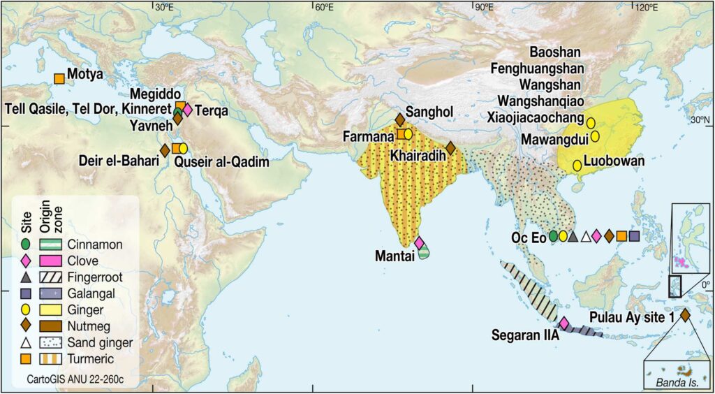
Columbus (who was looking for a new route to India, China, Japan and the ‘Spice Islands’ of Indonesia to bring back cargoes of silk and spices (ginger, turmeric, and cinnamon)) never saw the mainland United States.

Spain’s drive to enlarge its empire led other hopeful conquistadors to push further into the Americas, hoping to replicate the success of Cortés and Pizarro.

The exploits of European explorers had a profound impact both in the Americas and back in Europe. An exchange of ideas, fueled and financed in part by New World commodities, began to connect European nations and, in turn, to touch the parts of the world that Europeans conquered. (Lumen)

“On May 3, 1493, Pope Alexander VI, to prevent future disputes between Spain and Portugal, divided the world by a north-south line (longitude) 100 leagues (300 miles) west of the Cape Verde Islands.”

“In 1494, by the terms of the Treaty of Tordesillas, Spain and Portugal agreed to move that line to a meridian 370 leagues west of the Cape Verde Islands [in the Atlantic].” (Lloyd)

“Strictly speaking, there was no such thing as ‘the Pacific’ until in 1520-1 Fernao de Magalhãis, better known as Magellan, traversed the huge expanse of waters, which then received its name.” (Spate)

On November 28 1520, Ferdinand Magellan entered the “Sea of the South” (Mar Del Sur, which he later named the Pacific) and thereby opened up to Spain the possibility of an alternative route between Europe and the spices of the Orient.”  (Lloyd)

“After Magellan’s daring voyage round South America and across to the Philippines (1519-1521), the magnet of Pacific exploration was Terra Australis Incognita, the great southern continent supposed to lie between the Cape of Good Hope and the Straits of Magellan.”   (The Journal; Edwards)

With the conquest of Mexico in 1522, the Spanish further solidified their position in the Western Hemisphere. The ensuing discoveries added to Europe’s knowledge of what was now named America – after the Italian Amerigo Vespucci, who wrote a widely popular account of his voyages to a “New World.”

By 1529, reliable maps of the Atlantic coastline from Labrador to Tierra del Fuego had been drawn up, although it would take more than another century before hope of discovering a “Northwest Passage” to Asia would be completely abandoned.  (Alonzo L Hamby)

“Alvaro de Mendana, the Spanish voyager, sailed from Callao in Peru in 1567 and reached the Solomon Islands. It was not until 1595 that he went back, with Pedro Fernanadez de Quiros, found the Marquesas and got as far as the Santa Cruz Islands.”   (The Journal; Edwards)

Then, almost 50 years after the death of Christopher Columbus, Manila Galleons finally fulfilled their dream of sailing west to Asia to benefit from the rich Indian Ocean trade.

“The Spanish Galleons were square rigged ships with high superstructures on their sterns. They were obviously designed for running before the wind or at best sailing on a very ‘broad reach.’”

“Because of their apparently limited ability to ‘beat their way to windward’ (sail against the wind), they had to find trade routes where the prevailing winds and sea currents were favorable.”  (Lloyd)

Starting in 1565, with the Spanish sailor and friar Andrés de Urdaneta, after discovering the Tornaviaje or return route to Mexico through the Pacific Ocean, Spanish Galleons sailed the Pacific Ocean between Acapulco in Nueva España (New Spain – now Mexico) and Manila in the Philippine islands.

The galleons leaving Manila would make their way back to Acapulco in a four-month long journey.  The goods were off-loaded and transported across land to ships on the other Mexican coast at Veracruz, and eventually, sent to European markets and customers eager for these exotic wares.  (GuamPedia)

Spain had a long presence in the Pacific Ocean (1521–1898).  The Pacific coastline of Nueva España and Peru connected to the Philippines far to the west made the ocean a virtual Spanish Lake.

The “Spanish Lake” united the Pacific Rim (the Americas and Asia) and Basin (Oceania) with the Spanish in the Atlantic. (Buschmann etal)

The great wealth that poured into Spain triggered great interest on the part of the other European powers. With time, emerging maritime nations such as England, drawn in part by Francis Drake’s successful raids on Spanish treasure ships, began to take interest in the New World.  (State Department)

The USA is named after an Italian, Amerigo Vespucci (March 9, 1454 – February 22, 1512,) an explorer, financier, navigator and cartographer.  He sailed in 1499, seven years after Christopher Columbus first landed in the West Indies.

Columbus found the new world; but Vespucci, by travelling down the coast, came to the realization that it was not India at all, but an entirely new continent.

Later, it was a German clergyman and amateur geographer named Martin Waldseemüller and Matthias Ringmann, his Alsatian proofreader, who are reported to have first put the name “America” (a feminized Latin version of Vespucci’s first name) on the new land mass (April 25, 1507.)

The name ‘United States of America’ appears to have been used for the first time in the Declaration of Independence (1776.) At least no earlier instance of its use in that precise form has been found.  (Burnett)

© 2025 Ho‘okuleana LLC

Filed Under: Economy, Sailing, Shipping & Shipwrecks Tagged With: Pacific, Pacific Ocean, Spanish Lake, Manila Galleons, Acapulco, New Spain, Mexico, Hawaii, Philippines

August 3, 2025 by Peter T Young Leave a Comment

Explorers and Traders … the Pacific and Hawai‘i

The word ‘spice’ is derived from the Latin ‘species’, or ‘special wares’, and refers to an item of special value, as opposed to ordinary articles of trade.  Spices were highly valued because, as well as being used in cooking, many had ritual, religious or medical uses.

They were of high value because of their relative geographical scarcity. Spices could only be grown in the tropical East; South Asia served as a major source of spices – in the South of China, Indonesia, as well as in Southern India and Sri Lanka.

Among the most widespread were the spices cinnamon, pepper, clove, nutmeg, and mace. (Hancock)  Some spices, such as cloves and nutmeg, grew nowhere else in the world.

The spice trade was conducted mostly by camel caravans over land routes (known as the Silk Roads).  The Silk Roads were important routes connecting Asia with the Mediterranean world, including North Africa and Europe. (Deepanjana, UNESCO)

From as early as 2000 BC, spices, such as cinnamon from Sri Lanka and cassia from China, were exported along the Silk Road as far west as the Arabian Peninsula and the Iranian Plateau. Other goods were also exchanged/traded – cargoes from China included ivory, silk, porcelain, metals and gemstones.  (Deepanjana, UNESCO)

Later, Spice Routes were established; these were the name given to the network of sea routes that linked the East with the West.  The journey of the goods between all these links in the chain is called a trade route (the word ‘trade’ derives from a term meaning a track or course).

One of the major motivating factors in the European Age of Exploration was the search for direct access to the highly lucrative Eastern spice trade.

in 1513, a Spanish captain, Vasco Nuñez de Balboa, went into the interior of Darien (Panama). On September 24, 1513, Balboa sighted a new ocean. He called it the Mar del Sur, or ‘sea of the south’ (South Sea); later (1520), Ferdinand Magellan called it the Mare Pacificum, or Pacific Ocean.

The accounts of the first explorers revealed the potential for high-value commodity exchange, and voyages of exploration were soon followed by those of spice traders. (BOEM)

From 1500 AD onward, first Portugal, and then other European powers, attempted to control the spice trade, the ports which marketed spices, and eventually the territories which grew them. (Cartwright)

The Portuguese established trading posts in China at Macau in 1513, in Timor in 1515, and finally at Nagasaki, Japan in 1543. Within the next decades, Dutch competitors followed the Portuguese across the Indian Ocean and into Southeast Asia. (BOEM)

Then came the Spanish … on November 28 1520, Spaniard Fernao de Magalhais (Ferdinand Magellan) entered the eastern Pacific from the opposite direction, by way of the tip of South America, discovering the strait that now bears his name, and thereby opened up to Spain the possibility of an alternative route between Europe and the spices of the Orient.”  (Lloyd)

Magellan crossed the ocean to the Philippines, which he named Las Islas Filipinas in honor of the Spanish king, Felipe. (Spate) The Spanish ultimately prevailed against other European competition in terms of Pacific trade. They did this through the founding of their outpost at Manila (Philippines) in 1571 and the establishment of regular transpacific Manila Galleon voyages.

Once a year, gold and silver were transported west from Acapulco to Manila in exchange spices (pepper, clove and cinnamon), porcelain, ivory, lacquer and elaborate fabrics (silk, velvet, satin), collected from both the Spice Islands (Moluccas, Indonesia) and the Asian Pacific coast.

The Pacific fur trade was pioneered by the Russians, working east from Kamchatka along the Aleutian Islands to the southern coast of Alaska. (ESDAW)

Originally, Russia exported raw furs, consisting in most cases of the pelts of martens, beavers, wolves, foxes, squirrels, and hares. Between the 16th and 18th centuries, Russians began to settle in Siberia, a region rich in many mammal fur species, such as Arctic fox, lynx, sable, sea otter and stoat (ermine).

it was the French and  British who dominated Pacific exploration in the eighteenth century. Beginning in the mid-1700s, the rival nations began to send out scientific expeditions to explore and chart the islands of the Pacific.

British explorers included Samuel Wallis (1767–68) and Philip Carteret (1767–68). But by far the most wide-ranging and accomplished of the eighteenth-century explorers was the Englishman Captain James Cook, who made three separate voyages to the Pacific in 1768-71, 1772-75, and 1776-80. (Kjellgren, MetMuseum)

After Cook was killed in Hawai‘i, one of his officers – and later a Captain – George Vancouver continued to explore and chart the Northwest Coast.  Commercial traders soon followed, exchanging copper, weapons, liquor, and varied goods for sea otter pelts. (Barbour)

Following Cook’s ‘discovery’ of the opportunities in the fur trade, the North American maritime fur trade became the earliest global economic enterprise.  Cook’s ‘discovery’ resulted in the British and then the Americans participating in the trade.

Following the American Revolution, the new nation needed money and a vital surge in trade. In 1787, two ships (Columbia, captained by John Kendrick, and Lady Washington, captained by Robert Gray) left Boston on a mission around Cape Horn and into the Pacific Ocean. to establish new trade with China, settle an outpost on territory claimed by the Spanish, and find the legendary Northwest Passage.

Within ten years after Captain Cook’s 1778 contact with Hawai‘i, the islands became a favorite port of call in the trade with China.  The fur traders and merchant ships crossing the Pacific needed to replenish food supplies and water.

Needing supplies in their journey, the traders soon realized they could economically barter for provisions in Hawai‘i; for instance, any type of iron, a common nail, chisel or knife, could fetch far more fresh fruit, meat, and water than a large sum of money would in other ports.

A triangular trade network emerged linking the Pacific Northwest coast, China and the Hawaiian Islands to Britain and the United States (especially New England).  Practically every vessel that visited the North Pacific in the closing years of the 18th century stopped at Hawai‘i for refreshment and recreation.

As trade and commerce expanded across the Pacific, numerous countries were looking for faster passage and many looked to Nicaragua and Panama in Central America for possible dredging of a canal as a shorter, safer passage between the two Oceans.

Finally, in 1881, France started construction of a canal through the Panama isthmus.  By 1899, after thousands of deaths (primarily due to yellow fever) and millions of dollars, they abandoned the project and sold their interest to the United States.

After Panamanian independence from Columbia in 1903, the US restarted construction of the canal in 1905.  Finally, the first complete Panama Canal passage by a self-propelled, oceangoing vessel took place on January 7, 1914.

Later, when Navy Commander John Rodgers and his crew arrived in Hawaiʻi on September 10, 1925 on the first trans-Pacific air flight, they fueled the imaginations of Honolulu businessmen and government officials who dreamed of making Hawaiʻi the economic Crossroads of the Pacific, and saw commercial aviation as another road to that goal.

Two years later on March 21, 1927, Hawaii’s first airport was established in Honolulu and dedicated to Rodgers.  1959 brought two significant actions that shaped the present day make-up of Hawai‘i, (1) Statehood and (2) jet-liner service between the mainland US and Honolulu (Pan American Airways Boeing 707.)

Here is a link for more on Explorers and Traders: https://imagesofoldhawaii.com/wp-content/uploads/Explorers-and-Traders.pdf

© 2025 Ho‘okuleana LLC

Filed Under: Sailing, Shipping & Shipwrecks, Economy, General Tagged With: Hawaii, Pacific, Traders, Ecplorers, Silk Road, Spice Route

January 31, 2024 by Peter T Young Leave a Comment

Moananuiākea

Moananuiākea is the domain of Kanaloa, god of the ocean.  It is the ancestral home of the Hawaiian people.  Kealaikahiki is the name of an ancestral sea road that forms a heritage corridor connecting Hawaiʻi and the Kahiki Homeland. (KSBE)

“Kahiki” or “Kahiki Homeland” is a specific reference to the ancestral region that includes the Society Islands, Tuamotu Archipelago, and the Marquesas Islands, and may generally refer to other closely-related island groups.  (He Kama Na Kahiki Symposium)

Kahoʻolawe (Kanaloa) is an important ancestral marker for the Kealaikahiki pathway. The ʻili, the point, and the channel known as Kealaikahiki, as well as the island of Kahoʻolawe itself, constitute these markers. (He Kama Na Kahiki Symposium)

“Polynesian explorers first made their remarkable voyage from central Eastern Polynesia Islands, across the doldrums and into the North Pacific, to discover Hawai‘i.”  (Kirch)

“Most important from the perspective of Hawaiian settlement are the colonization dates for the Society Islands and the Marquesas, as these two archipelagoes have long been considered to be the immediate source regions for the first Polynesian voyagers to Hawai‘i. …”

“In sum, the southeastern archipelagoes and islands of Eastern Polynesia have a set of radiocarbon chronologies now converging on the period from AD 900–1000.”  (Kirch)

Research indicates human colonization of Eastern Polynesia took place much faster and more recently than previously thought. Polynesian ancestors settled in Samoa around 800 BC, colonized the central Society Islands between AD 1025 and 1120 and dispersed to New Zealand, Hawaiʻi and Rapa Nui and other locations between AD 1190 and 1290.  (Hunt; PVS)

“There is also no question that at least O‘ahu and Kauai islands were already well settled, with local populations established in several localities, by AD 1200.”  (Kirch)

On November 28 1520, Ferdinand Magellan was the first European to enter “Sea of the South” (which he later named the Pacific (meaning peaceful)) and thereby open up to Spain the possibility of an alternative route between Europe and the spices of the Orient.”  (Lloyd)

Ferdinand Magellan is often credited as being the first person to have circumnavigated the globe; his expedition of five ships and crew of 270 set sail on September 20, 1519 as part of an attempt to find a western route to the spice-rich East Indies in modern-day Indonesia.

Some history books still say Ferdinand Magellan “is most known for being the first explorer to circumnavigate the world.” (The Brave Magellan: The First Man To Circumnavigate The World – Biography 3rd Grade Children’s Biography Books)

However, although he had masterminded the first expedition to sail around the world, he didn’t complete the voyage.  Along the way, Magellan was killed on April 27, 1521 on Mactan Island, Cebu, Philippines.

The first European to complete the circumnavigation was Magellan’s second-in-command, Juan Sebastian de Elcano, who took over after his death. At that point, the final crew had only 18 men. (Royal Museums Greenwich and PennToday)

Almost 50 years after the death of Christopher Columbus, Manila galleons finally fulfilled their dream of sailing west to Asia to benefit from the rich Indian Ocean trade.

Starting in 1565, with the Spanish sailor and friar Andrés de Urdaneta, after discovering the Tornaviaje or return route to Mexico through the Pacific Ocean, Spanish galleons sailed the Pacific Ocean between Acapulco in New Spain (now Mexico) and Manila in the Philippine islands.

Once a year, gold and silver were transported west to Manila in exchange spices (pepper, clove and cinnamon), porcelain, ivory, lacquer and elaborate fabrics (silk, velvet, satin), collected from both the Spice Islands (Indonesia) and the Asian Pacific coast, in European markets.

The galleons leaving Manila would make their way back to Acapulco in a four-month long journey.  The goods were off-loaded and transported across land to ships on the other Mexican coast at Veracruz, and eventually, sent to European markets and customers eager for these exotic wares.  (GuamPedia) The Manila Galleon Trade lasted for 250 years and ended in 1815 with Mexico’s war of independence.

“The English circumnavigations by Drake (1577-1580) and Cavendish (1586-1588) were not rich in discoveries. The Dutch merchant Isaac Ie Maire, with Willem Corneliszoon Schouten, reached the Pacific in 1615 via Cape Horn (which they named)”.

“Sailing from there, the Dutch had made several sightings of the coast of Australia, north, west and south, in the early seventeenth century, and Anthony van Diemen, governor-general of the Dutch East Indies from 1631 to 1645, was responsible for a number of expeditions”.

“[L]ater, another Dutch expedition, under Jacob Roggeveen, left the Netherlands in 1721 in search of the southern continent.  Roggeveen went through the Strait of Le Maire and found Easter Island and Samoa before reaching Batavia after a year’s voyage.”

“The English had now come strongly on the scene, with the expeditions of Narborough up the South American coast (1669-1671), a mixed assembly of buccaneers, adventurers and privateers, including Dampier, Wafer, Cowley, Ringrose, Woodes, Rogers and Shelvocke, followed by the grand naval expedition of 1740-1744 under Anson.”

“As far as discoveries go, the most important of these men was the remarkable amateur William Dampier, whose painfully assembled New Voyage Round the World (1697) set alight the imagination of eighteenth-century England.”

“On this first voyage Dampier had touched on Australia (New Holland), ‘a very large Tract of Land’, and had thought the inhabitants ‘the miserablest People in the World’. He returned on his second voyage but was only able to make a cursory investigation of the north-western and northern coasts.”

“The major period of English exploration in the Pacific followed the ending of the Seven Years War with France in 1763. The Earl of Egmont, First Lord of the Admiralty from 1763 until 1766, sent out John Byron in the Dolphin in 1764, and on its return from a speedy circumnavigation in 1766, sent the ship out again under Samuel Wallis, with Philip Carteret in the Swallow as consort.”

“James Cook, thirty-nine years of age, a master in the Navy engaged on the survey of Newfoundland, was proposed by the Navy, and during April and May 1768 it was agreed that he should become leader of the expedition.” (The Journal; Edwards)

In the dawn hours of January 18, 1778, on his third expedition, British explorer Captain James Cook on the HMS Resolution and Captain Charles Clerke of the HMS Discovery first sighted what Cook named the Sandwich Islands (that were later named the Hawaiian Islands.)

Hawaiian lives changed with sudden and lasting impact, when western contact changed the course of history for Hawai‘i.

Following the American Revolutionary War, American Captain John Kendrick was among the first citizens of the new nation to sail into the Pacific. The new nation needed money and a vital surge in trade.

In 1787, a group of Boston merchants decided to send him on a two ship mission around Cape Horn and into the Pacific Ocean, to establish new trade with China, settle an outpost on territory claimed by the Spanish and find the legendary Northwest Passage.

The maritime fur trade focused on acquiring furs of sea otters, seals and other animals from the Pacific Northwest Coast and Alaska. The furs were to be mostly sold in China in exchange for tea, silks, porcelain and other Chinese goods to be sold in the US.

Kendrick visited Hawai‘i a number of times and is credited for initiating the sandalwood trade (Hawai‘i’s first commercial export). He died at Honolulu Harbor, December 12, 1794.

© 2023 Ho‘okuleana LLC

Filed Under: Hawaiian Traditions, Place Names, Sailing, Shipping & Shipwrecks, General Tagged With: Hawaii, Captain Cook, Pacific, John Kendrick, Magellan, James Cook

November 19, 2023 by Peter T Young Leave a Comment

Connections

“There has never been any agreement, as to the origin of this isolated island people, or the reasons why this type is only found scattered over all the solitary islands in the eastern part of the Pacific.”  (Thor Heyerdahl)

Solomon Lehuanui Kalaniomaiheuila was the son of Peleioholani (uncle to the Kings Kamehameha IV and Kamehameha V) and Piikeakaluaonalani (mother.)  For many, Peleioholani was considered an important Hawaiian antiquarian and the final word in Hawaiian genealogy, especially of the chiefs and royal families.

He wrote of the Hawaiian history.  One of Peleioholani’s theories notes, “The ancestors of the Hawaiian race came not from the islands the South Pacific – for the immigrants from that direction were late arrivals there – but from the northern direction (welau lani,) that is, from the land of Kalonakikeke, now known as Alaska.”

Others have noted connections between people in the Pacific and other parts of the world.

The idea of a trans-Pacific crossing has had its proponents within scholarly archaeology. Heyerdahl’s (1950) Kon-Tiki experiment demonstrated that such a crossing (from Peru to Raroia) was possible. But simply because such an experiment is possible does not mean that it happened.  (Boulanger)

Meggers et al. reported on what they interpreted as similarities between ceramics of the Valdivia culture of coastal Ecuador and the middle Jomon culture of western Japan. Yet, concerted archaeological research over the past 200 years has failed to provide any substantial material evidence for a trans-Pacific origin for any Native American culture.

Some suggest the sweet potato is proof of connection … On his voyages across the Pacific, Captain James Cook encountered geographically disparate Polynesian societies, including those living on Easter Island, Hawai‘i and the north island of New Zealand. These far-flung communities cultivated a common crop, sweet potato.  (Denham; NCBI)

Researchers later sampled specimens brought back by early explorers (including Cook.) They found that the DNA evidence indicated that the sweet potato had migrated to Polynesia long before European explorers had made their way to that part of the world.  (Yirda; PHYS)

Peruvians first domesticated the sweet potato around 8,000-years ago. And though the crop spread from there, the means by which it traveled have always remained contentious.

One possibility was that Polynesian sailors first brought it home from across the ocean: The oldest carbonized sweet potato evidence in the Pacific hails back to about 1,000 AD – 500-years before Columbus sailed to the Americas.

The Polynesian word for sweet potato resembles the central Andes’ Quechua people’s word for the vegetable.  (SmithsonianMag)  Polynesian word for sweet potato ‘kuumala’ resembles ‘kumara,’ or ‘cumal,’ the words for the vegetable in Quechua, a language spoken by Andean natives. (NPS)

But did Polynesians land on South American beaches, or did Native Americans sail into the Pacific to reach Rapa Nui?  (Lawler; ScienceMag)  Or, did its seeds possibly hitch a ride on seaweed or natural raft, or gotten lodged in the wing of a bird? (NPR)

“Our studies strongly suggest that Native Americans most probably arrived (on Rapa Nui) shortly after the Polynesians (got there.)”  (Erik Thorsby; ScienceMag)

But many scientists say that Pacific currents and Polynesian mastery of the waves make it more likely that the Polynesians were the voyagers. They may have sailed to South America, swapped goods for sweet potatoes and other novelties—and returned to their island with South American women.  (Lawler; ScienceMag)

“There’s a lot of evidence accumulating … that the Polynesians made landfall in South America.  We think they had sophisticated, double-hulled canoes – like very large catamarans – which could carry 80 or more people and be out to sea for months.”  (Kirch; NPR)

The researchers found strong evidence that “supports the so-called tripartite hypothesis, which argues that the sweet potato was introduced to Polynesia three times: first through premodern contact between Polynesia and South America, then by Spanish traders sailing west from Mexico, and Portuguese traders coming east from the Caribbean.”

“The Spanish and Portuguese varieties ended up in the western Pacific, while the older South American variety dominated in the east”.  (SmithsonianMag)

It is believed the sweet potato then made three independent trips to Southeast Asia. The Polynesians probably introduced it in 1100 AD. While the Spanish and Portuguese brought other varieties from the Americas around 1500. (NPR)

Peter Marsh makes several Canadian connections to Pacific Islands, noting, that archaeological and cultural evidence suggests that there is a strong connection between Coastal Canada and Polynesia. Haida Gwaii (Queen Charlotte Islands) is an archipelago off the coast of British Columbia, Canada.

Marsh notes that both the Polynesians and Haida people worked in stone in the same manner, designs of implements were almost identical. The use of pottery was completely absent in both cultures.  The design and way of manufacture of the following artifacts bear a striking resemblance:

  • Tahitian and Haida stone pounders are almost identical.
  • Stone bowls found in Kauai and stone bowls found in the Bella Coola valley from a pre-existing culture are very similar.
  • Maori and NW Coastal Indian war clubs both have the gaping angry mouth motif on the handle.
  • Tattooing tool kit design indicates Polynesian kit derived from Haida tattooing implements.
  • Fish hook design is almost identical
  • Fish hook pendants are also identical
  • Petroglyphs are similar
  • Spiritual carvings such as the Tiki are amazingly similar in both cultures.
  • Large totem poles with figures stacked on top of one another with their tongues sticking out are common in both Maori and Haida cultures.
  • Haida and Marquesan carvings have similar shaped eyes and mouths.
  • Carvings around building entrances where the legs form an archway.
  • The practice of inlaying of Paua shell into the eyes of figures is a style used in both cultures.
  • Maori war canoes are similar in design to Kwakuitl canoes.
  • The use of calabashes instead of pottery for carrying water is common to both cultures.
  • The use of hot rocks to steam and widen canoes, is practiced by both Maori and Kwakuitl.
  • Earth ovens are used by both cultures
  • The unique practice of rubbing noses as a way of greeting is used in both Maori and some tribes in the Canadian NW. This suggests definite cultural and spiritual connection.
  • The use of the glottal stop in speech is similar e.g.; Hawai‘i and Haida Gwai‘i.

© 2023 Ho‘okuleana LLC

Filed Under: General, Hawaiian Traditions, Place Names Tagged With: Hawaii, Petroglyphs, Pacific

August 22, 2023 by Peter T Young Leave a Comment

Kalonakikeke

“There has never been any agreement, as to the origin of this isolated island people, or the reasons why this type is only found scattered over all the solitary islands in the eastern part of the Pacific.”  (Thor Heyerdahl)

Solomon Lehuanui Kalaniomaiheuila Peleioholani (also called Peleioholani the 4th or Lehuanui, or simply, Peleioholani) (1843-1916) was the son of Peleioholani (uncle to the Kings Kamehameha IV and Kamehameha V) and Piikeakaluaonalani (mother.)

His great grandfather was the high chief Keʻeaumoku (father of Kaʻahumanu,) one of the ablest supporters of Kamehameha I.

As a boy, Peleioholani was the protégé of Kamehameha IV and his Queen Emma and the companion of their son Prince Albert (“Ka Haku O Hawaiʻi, “The Lord of Hawaiʻi.”)

During the short life of the little Prince, Peleioholani was his playmate, and both were treated with utmost respect by all they met. During this time, Peleioholani lived at the residence of Kekūanāo’a (hānai father of Bernice Pauahi Bishop.)  (Pacific Commercial Advertiser, January 22, 1902)

In 1874, he returned to Hawaiʻi and was a well-respected genealogist.  For many, Peleioholani was considered an important Hawaiian antiquarian and the final word in Hawaiian genealogy, especially of the chiefs and royal families.

Peleioholani was a High Chief, and in many ways both the pinnacle and terminus of the old royal blood lines from Maui, Oʻahu, Hawaiʻi and Kauai.

His grandparents were among those who sided with Kamehameha I to achieve unity of the islands. His father was an uncle to the Kings Kamehameha IV and Kamehameha V and he was himself one of the highest ranking chiefs in the Hawaiian Islands.  (kekoolani-org)

He also wrote of the Hawaiian history.  One work, ‘The Ancient History of Hookumu-ka-lani Hookumu-ka-honua,’ was a commentary of the ancient Hawaiian cosmogonies (creation theories.)

One of Peleioholani’s theories in that book notes, “The ancestors of the Hawaiian race came not from the islands the South Pacific – for the immigrants from that direction were late arrivals there – but from the northern direction (welau lani,) that is, from the land of Kalonakikeke, now known as Alaska.”

“According to this tradition, a great flood that occurred during the reign of Kahiko-Luamea on the continent of Ka-Houpo-o-Kane, (“The Bosom of Kane”) and carried away a floating log of wood named Konikonihia.”

“On this log was a precious human cargo and it came to rest on the land of Kalonakikeke (“Alaska”).”

“On this log were the first man and woman who came to Kalonakikeke from the continent of Ka-Houpo-o-Kane, they were Kalonakiko-ke (“Mr Alaska”) and his wife Hoomoe-a-pule (“Woman of my dreams”).”

“They were said to both be high chiefs of the countries of Kanaka-Hikina (“Person of the east”) and Kanaka-Komohana (“Person of the west”) and were descended from the great great ancestor Huka-ohialaka.”

“Many generations later, Chief Nuu, travelled with his wife, Lilinoe, their three sons and their three wives in a canoe called Ka-Waa-Halau-Alii-O-Ka-Moku (“The royal canoe of the continent”), and it rested upon Mauna Kea (“White Mountain”), on the island of Hawaii. They were the first Hawaiians.”

“According to Hawaiian genealogies, Chief Nuu lived around 200 BCE. (This agrees closely with the genetic evidence showing the time of arrival of Polynesians in the Pacific)”  (Peleioholani; Poepoe translation; UC Riverside)

© 2023 Ho‘okuleana LLC

Filed Under: Sailing, Shipping & Shipwrecks, General, Hawaiian Traditions Tagged With: Kalonakikeke, Alaska, Pacific

  • 1
  • 2
  • 3
  • Next Page »

Images of Old Hawaiʻi

People, places, and events in Hawaiʻi’s past come alive through text and media in “Images of Old Hawaiʻi.” These posts are informal historic summaries presented for personal, non-commercial, and educational purposes.

Info@Hookuleana.com

Connect with Us

  • Email
  • Facebook
  • LinkedIn
  • Twitter
  • YouTube

Recent Posts

  • Doubtful Island of the Pacific
  • John Meirs Horner
  • Prostitution
  • Malukukui
  • Fight for Parker Ranch
  • Kilauea Masonic Lodge
  • Colonialism

Categories

  • General
  • Ali'i / Chiefs / Governance
  • Buildings
  • Missionaries / Churches / Religious Buildings
  • Hawaiian Traditions
  • Military
  • Place Names
  • Prominent People
  • Schools
  • Sailing, Shipping & Shipwrecks
  • Economy
  • Voyage of the Thaddeus
  • Mayflower Summaries
  • American Revolution

Tags

Albatross Al Capone Ane Keohokalole Archibald Campbell Bernice Pauahi Bishop Charles Reed Bishop Downtown Honolulu Eruption Founder's Day George Patton Great Wall of Kuakini Green Sea Turtle Hawaii Hawaii Island Hermes Hilo Holoikauaua Honolulu Isaac Davis James Robinson Kamae Kamaeokalani Kamanawa Kameeiamoku Kamehameha Schools Lalani Village Lava Flow Lelia Byrd Liliuokalani Mao Math Mauna Loa Midway Monk Seal Northwestern Hawaiian Islands Oahu Papahanaumokuakea Marine National Monument Pearl Pualani Mossman Queen Liliuokalani Thomas Jaggar Volcano Waikiki Wake Wisdom

Hoʻokuleana LLC

Hoʻokuleana LLC is a Planning and Consulting firm assisting property owners with Land Use Planning efforts, including Environmental Review, Entitlement Process, Permitting, Community Outreach, etc. We are uniquely positioned to assist you in a variety of needs.

Info@Hookuleana.com

Copyright © 2012-2024 Peter T Young, Hoʻokuleana LLC


Loading Comments...