Images of Old Hawaiʻi

  • Home
  • About
  • Categories
    • Ali’i / Chiefs / Governance
    • American Protestant Mission
    • Buildings
    • Collections
    • Economy
    • Missionaries / Churches / Religious Buildings
    • General
    • Hawaiian Traditions
    • Other Summaries
    • Mayflower Summaries
    • Mayflower Full Summaries
    • Military
    • Place Names
    • Prominent People
    • Schools
    • Sailing, Shipping & Shipwrecks
    • Voyage of the Thaddeus
  • Collections
  • Contact
  • Follow

August 9, 2025 by Peter T Young Leave a Comment

Rescue in Paradise

Douglas developed the B-18 “Bolo” to replace the Martin B-10; the new model was based on the Douglas DC-2 commercial transport.  The B-18 prototype competed with the Martin 146 (an improved B-10) and the four-engine Boeing 299, forerunner of the B-17 Flying Fortress, at the Air Corps bombing trials at Wright Field in 1935.

Although many Air Corps officers judged the Boeing design superior, the Army General Staff preferred the less costly Bolo; contracts were awarded for 82-planes, the order was increased to 132 by June of 1936.  (Trojan)

The Bolo remained the Air Corps’ primary bomber into 1941. Thirty-three B-18s were based in Hawaiʻi with the 5th Bombardment Group and 11th Bombardment Group.

One of those Hawaiʻi B-18 Bolos, piloted by Boyd Hubbard Jr, took off from Hickam Field at 7 pm February 25, 1941 for a routine inter-island night instrument-navigation training flight. (Trojan)

Other members of the crew were 2nd Lt Francis R. Thompson (co-pilot), S/Sgt Joseph S. Paulhamus (flying engineer), Pvt William Cohn (radio operator), Pvt Fred C. Seeger (passenger), Pvt Robert R. Stevens (passenger) WIA. (Aviation Safety Network)

Their flight path took them over the Island of Hawaiʻi.  While flying on instruments at 10,000-feet, Hubbard’s B-18 suffered a main bearing failure in the left engine.  Hubbard headed to Suiter Field, the Army’s auxiliary field (it is now known as Upolū Point Airport.)

Hubbard made a last split-second correction prior to the crash. As he later described it, the mountain just loomed up before him in the darkness and he just reacted. He pulled back hard on the wheel and the aircraft stalled and belly flopped into the thick underbrush.

Airmen from Hickam later described the site as the “Worst possible place for a forced landing in the Islands.”  (Trojan)

“The quiet of the wooded mountains was shattered by a roaring crash! No human ear heard the sound; but shortly thereafter the phone in my office rang with an urgent persistance.”

They called Frederick Christian Koelling (superintendent of the Kohala Ditch Co and engineer for the Hawi Mill and Plantation Co. (Nellist))

“I picked up the receiver with no inkling of the adventure into which this simple gesture would lead me. The voice which answered was an unfamiliar one, but the message imparted sent me running for help and set in motion the ’rescue in paradise’ which saved the lives of a gallant crew of six army fliers.”

“Prior to the rescue attempt, I asked the Army to locate Bill Sproat, our area supervisor, and fly him over the site of the crash. Bill, being thoroughly ‘at home”’ in this area, could easily give me directions which I felt would minimize the time required to effect a ground rescue.”

“On Wednesday, February 26th, having talked with Bill by telephone and determined the approximate location of the downed plane, I gathered a party of co-workers including Leslie Hannah, Ronald May, Elders Johnson and Lyons, and left Hawi, our home base, at noon for Pololu.”

“Arriving at Pololu, the first station in the Kohala Sugar Company irrigation system, we obtained mules and rode up the winding trail to Kaukini Camp.”

The next day, “we left Kaukini Camp just as dawn was breaking. Our party of eight now pushed on to the end of the trail where we dismounted and the mules were staked out. The area, known as Wailoa, was not as familiar to us as the previous terrain. However, a foot trail had been cleared for another two miles or more through these ravines.”

“We followed this trail until we reached the spot previously agreed upon between Bill Sproat and myself as being the most likely approach to where the plane had gone down.”

“We hacked our way up and down a series of steep ravines, crossing a rushing stream at the bottom of each. … In order to cover more ground, we separated into two parties of four and followed the edges of two gulches above which we had determined was the wrecked plane.”

“After more than an hour of steady climbing, always hampered by the dense foliage, vines and marshy soil underfoot, we met at the top of the second gulch. For another two and one-half hours we struggled and hacked our way with machetes over, through and around trees, staghorn ferns, rotten brush and clinging vines.”

“Two of our men had climbed trees above the underbrush to listen for an acknowledgement from the flyers. The men claimed they heard answering shots sounding like firecrackers in the still air, pak-pak!”

“Immediately the lagging spirits of the party revived. and we continued on with renewed vigor, putting considerable distance behind us over firmer terrain with less undergrowth.”

“After another half hour of steady climbing, we again checked our position, firing more rifle-shots, and again we could hear an answering, pak, pak, pak! As we strained our ears to pin-point the shots, suddenly one of our group saw a flare, a small parachute trailing smoke and fire a considerable distance away.”

“Another ridge, another gulch, until we finally reached a point where we could call to the stranded flyers. … Despite the fact that they had acknowledged our calls, we were very much in doubt as to the physical well-being of the survivors.”

“The scattered debris, the crushed and fallen trees, plus the sight of the badly damaged plane, caused considerable apprehension, as to the condition of the flyers; badly injured or worse.

“Miraculously, and no doubt due to the thick growth of trees and shrubs, the plane had landed with far less impact than it would have, had it crashed in a desert or open area. The survivors were only slightly hurt, a mighty fortunate crew indeed!”

“One of the aviators had a bandage over one eye; another an injured hand, a third had one pants leg ripped off and a lacerated leg, and the fourth bad a bruise on his face!”

“Captain Boyd Hubbard, leader of the crew, had a rather badly bruised arm, but the Lieutenant escaped with only a scratch!  The marvelous condition of the flyers was a most welcome sight to their rescuers. If they had been seriously injured we would have had a much more difficult time getting them down out of the mountains.”

“After some consultation, it was decided that our party and two of the least injured aviators would return to the Kaukini Camp for the night.  Bill Sproat was at that time, leading another party over our trail.”

Among this group were Major Higgins from Wheeler Field, a Dr. Hall, two mechanics and a number of Army personnel. Our presence at the scene would not be necessary as this group was better equipped to assist in the salvage work on the aircraft. Therefore, we immediately set out on our return trip.”

“It was with profound relief that we relaxed somewhat in our saddles after the exhausting descent. However, our troubles were not all over. We now proceeded entirely in darkness. Suddenly, one of the pack mules broke loose and lunged forward down the trail dragging its tie rope. Ronald May, whose mule was next in line, pursued the pack mule.”

“Fortunately, the tie rope became lodged in a rock cleft before the mule had traveled very far. Ronald leapt from his mount and grabbed for the tie rope – at the same instant, one of the aviators brought his flash into play. The sudden bright light [panicked] the mule causing the animal to plunge into Ronald who fell back off the trail and down the cliff coming to a splashing halt in a pool of water ten feet below.”

“We all came to a quick halt, pulling up our mules on the narrow trail. By great good fortune, Ronald was promptly located and, with the aid of a rope, we hauled him back up to the trail, more doused than hurt. The recalcitrant mule was firmly tied into the pack train and we all proceeded on to the stables above the Kaukini Camp.”

“Upon reaching Pololu, we disbanded and I drove the two aviators to [Upolū] Point Field from whence they were flown to Wheeler Field in Oahu. During the following days, the entire crew was brought out of the mountains along with all salvageable parts of the aircraft (the bombsight and instruments, Aviation Safety Network) by Bill Sproat and the Anny personnel who had accompanied him to the site.”

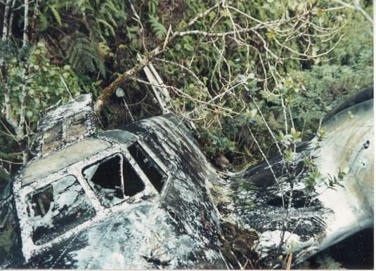
Decades later (during 1980s?) Gary Larkins visited this site and photographed it with top turret intact. Internal fittings and the top turret were removed, including the retractable top turret and nose cone. These parts went to the USAF Museum for use in their restoration of B-18A Bolo 37-469, but the turret did not fit their aircraft. (Aviation Safety Network) (Special thanks to Cindy McKievick for providing her grandfathers’ (FC Koelling) summary of his heroic rescue.)

© 2025 Hoʻokuleana LLC

Filed Under: General, Military, Place Names, Prominent People Tagged With: Hamakua, Kohala Ditch, Frederick Christian Koelling, Bolo, Bill Sproat, Hawaii

June 29, 2025 by Peter T Young 2 Comments

The Perfect Nut

If you have every watched the game being played, your first thought (question) is if there really are any rules associated with it.

The first publicly recorded Australian Football match took place between Scotch College and Melbourne Grammar on the rolling paddocks next to the Melbourne Cricket Ground in 1858.

Each team selected its own umpire. Scotch College chose Dr John Macadam, Melbourne Grammar School Tom Wills. What qualifications Macadam had for the post, we don’t know. After three playing days, the game ended in a draw with each team kicking one goal. (University of Melbourne)

No, that is the basis of this story.

How about? … John Macadam, the man who on March 3, 1862 delivered the first-ever lecture at the Melbourne University Medical School and who went on to become Professor of Theoretical and Practical Chemistry at Melbourne University in 1865.

No, that’s not it either.

However, it’s the same John Macadam in each story … as well as the story that follows.

Given the variety above, it shouldn’t surprise you that John Macadam is the namesake for the macadamia nut. (Although, allegedly, Macadam had not seen a macadamia nut tree, or even tasted the macadamia nut.)

In 1857, German-Australian botanist Ferdinand von Mueller gave the genus of this plant the scientific name Macadamia – named after von Mueller’s friend Dr John Macadam, a noted scientist and secretary to the Philosophical Institute of Australia.

John Macadam, scientist, medical doctor, philosopher and politician, was born in May 1827 at Northbank, near Glasgow, Scotland. (His name has often been misspelled with a capital “A” as in “Adam.”)

Although in ill health by March 1865, he went to New Zealand to give expert testimony as an analytical chemist in a murder trial involving the use of poison. Along the way, he fractured his ribs in rough weather.

Subsequently, he developed pleurisy (inflammation of the moist, double-layered membrane that surrounds the lungs and lines the rib cage) and died at sea on September 2, 1865 (at the age of 38.) (CTAHR)

Let’s look back.

For at least 40,000 years, Aborigines have lived in macadamia heartland. As hunters and gatherers, they had an intimate understanding of their environment. The wild macadamias usually grew in dense rainforests, with competition from other trees and absence of light resulting in their producing few nuts.

However, trees growing at the edge of the rainforest or where the Aborigines had encouraged them by burning around each tree generally produced annual crops. Macadamia nuts were a treasured food but a very minor part of the Aboriginal diet due to their rarity. (McConachie)

In 1828, Alan Cunningham (explorer and botanist) was the first Western person to record the macadamia. Other names for Macadamia Nuts are Bush nut, Queensland nut, Queen of nuts, Macadamia, Bauple nut, Boombera, Jindilli and Gyndl.

Macadamia seeds were first imported into Hawaiʻi in 1882 by William Purvis; he planted them in Kapulena on the Hāmākua Coast. (Purvis is also notable for importing the mongoose – to rid his Hāmākua sugar plantation of rats.)

A second introduction into Hawaii was made in 1892 by Robert and Edward Jordan who planted the trees at the former’s home in Nuʻuanu on Wyllie Street in Honolulu. This introduction became the source of the principal commercial varieties cultivated in Hawaiʻi. (Storey)

The Macadamia Nut is Australia’s only native plant to have become an international food. Although an Australian native, the macadamia nut industry was started in Hawaiʻi (Australian farmers did not take advantage of the tree until 1950.)

In 1922, Ernest Sheldon Van Tassel organized the Hawaiian Macadamia Nut Company to produce and process macadamia nuts. Two orchards were established by this company: one (‘Nutridge’) on the Tantalus slopes overlooking Honolulu at an elevation of about 900 feet, and the other at Keauhou at about 1,800 feet elevation on the Island of Hawaiʻi. By 1934, there were about 25-acres planted on Tantalus and about 100-acres at Keauhou. (CTAHR)

Commercial processing of macadamia nuts began in 1934 at Van Tassel’s new factory in Kaka‘ako. The nuts were shelled, roasted, salted, bottled and marketed there as “Van’s Macadamia Nuts.” (Schmitt)

In order to stimulate interest in macadamia culture, beginning January 1, 1927, a Territorial law exempted properties in the Territory, used solely for the culture or production of macadamia nuts, from taxation for a period of 5 years.

Macadamia nut candies became commercially available a few years later. Two well-known confectioners, Ellen Dye Candies and the Alexander Young Hotel candy shop, began making and selling chocolate-covered macadamia nuts in the middle or late 1930s. Another early maker was Hawaiian Candies & Nuts Ltd., established in 1939 and originators of the Menehune Mac brand. (Schmitt)

The first major attempt at large-scale commercialization of macadamia nuts was made in 1948 by Castle & Cooke, Ltd., in their venture at Keaʻau on the island of Hawaiʻi. Later, another of the former ‘Big 5’ companies, C Brewer and Company Ltd, bought out C&C and changed the name to Mauna Loa Macadamia Nut Corp. (Hershey’s later bought the Mauna Loa brand.)

Then, in 1962, MacFarms of established one of the world’s largest single macadamia nut orchards with approximately 3,900-acres on the South Kona coast of the Big Island of Hawaiʻi.

Today, about 570 growers farm 17,000 acres of macadamia trees, producing 40 million pounds of in-shell nuts, valued at over $30 million. Additionally, nuts are imported from South Africa and Australia, who currently lead the world market, with Hawai‘i at #3. (hawnnut)

The harvesting season for macadamia nuts runs from August through January. During Hawai’i’s cooling autumn months, mature macadamia nuts safely protected by sturdy shells and husks drop to the ground, and farmers hand-gather or mechanically harvest.

Under favorable conditions, a ten-year old tree can produce up to 150 pounds of in-husk nuts. De-husking is the first step needed. Next, a drying process decreases nut moisture from about 25 percent to 1.5 percent. Equipment that can exert 300 pounds of pressure cracks the shells. The raw kernels that emerge are now ready for grading, roasting, final drying and processing. (olsontrust)

Macadamias are a high energy food and contain no cholesterol. The natural oils in macadamias contain 78 per cent monounsaturated fats, the highest of any oil, including olive oil.

Macadamias are also a good source of protein, calcium, potassium and dietary fiber and are very low in sodium. The protein component of nuts is low in lysine and high in argentine. (BaupleMuseum)  Horticulturalist Luther Burbank is credited with calling macadamias the ‘perfect nut.’ (NY Times)

© 2025 Hoʻokuleana LLC

macadamia-nuts-husk-shell-nut
John_Macadam
John_Macadam
Nutridge-Van_Tassel_Tantalus Home-HonoluluMagazine
macadamia-olson
macadamia-olson
macadamia-trees
macadamia-trees
Macadamia flowers
Macadamia flowers
macadamia-bunch
macadamia-bunch
hawaiian-macademia-nuts-with husks
Nuts to catch in-husk macadamia nuts falling from trees
Hamakua Macadamia-in-husk
Mauna_Loa_Mac_Nuts-GoogleEarth
MacFarms-GoogleEarth
Mongoose-Purvis
Mongoose-Purvis
Australian Football-Tom_Wills_statue

Filed Under: General, Economy Tagged With: John Macadam, Ernest Sheldon Van Tassel, Hawaii, Hamakua, Macadamia Nuts

February 25, 2025 by Peter T Young Leave a Comment

Worst Possible Place For A Forced Landing In The Islands

While there is no good place to crash land an airplane, in 1941 the crew of the Army’s B-18 Bolo (serial number 36-446, constructors number 1747) found what was described as the “worst place.”

Prior to September 18, 1947 (the time the US Air Force was formed,) military aviation was conducted by the Army or Navy.

But let’s step back a bit.

In 1935, a design competition and “fly-off” was held to select a replacement for the Martin B-10/12 the standard bomber then in service with the United States Army Air Corps (USAAC.)

Douglas developed the B-18 “Bolo” to replace the Martin B-10; the new model was based on the Douglas DC-2 commercial transport.  The B-18 prototype competed with the Martin 146 (an improved B-10) and the four-engine Boeing 299, forerunner of the B-17 Flying Fortress, at the Air Corps bombing trials at Wright Field in 1935.

Although many Air Corps officers judged the Boeing design superior, the Army General Staff preferred the less costly Bolo; contracts were awarded for 82-planes, the order was increased to 132 by June of 1936.

Although designated a reconnaissance and bomber aircraft, the Douglas B-18 flew other important missions.  Hickam B-18s towed targets for gunnery practice by the coast artillery ground troops.   The targets were attached to steel cables and reeled several hundred feet aft of the aircraft.   (Trojan)

Though equipped with inadequate defensive armament and underpowered, the Bolo remained the Air Corps’ primary bomber into 1941. Thirty-three B-18s were based in Hawaiʻi with the 5th Bombardment Group and 11th Bombardment Group.

One of those Hawaiʻi B-18 Bolos, piloted by Boyd Hubbard Jr, took off from Hickam Field at 7 pm February 25, 1941 for a routine inter-island night instrument-navigation training flight.  Three other B-18s trained with them that night.

Their flight path took them over the Island of Hawaiʻi.  While flying on instruments at 10,000-feet, Hubbard’s B-18 suffered a main bearing failure in the left engine.  Hubbard headed to Suiter Field, the Army’s auxiliary field (it is now known as Upolū Point Airport.)

Although all possible fuel and cargo was jettisoned, the aircraft was too heavily loaded to maintain altitude on one engine.  As the aircraft descended the other engine began sputtering.  The crew believed they were over the ocean at the time in heavy fog during the dark night.

Hubbard made a last split-second correction prior to the crash. As he later described it, the mountain just loomed up before him in the darkness and he just reacted. He pulled back hard on the wheel and the aircraft stalled and belly flopped into the thick underbrush.

The undergrowth was so dense the plane settled into it and did not slide forward very far.  The crew felt the plane hit the tops of some trees and skid for about 75 yards before coming to rest at about the 3500-foot elevation in a gulch on the side of the Kohala mountain.  (Trojan)

Lee Webster, a Flight Engineer on one of the other B-18s in the group, reportedly gave this account of the accident, “I was just becoming accustomed to the eerie feeling of night flying by the time we started our second leg of the triangle toward a point somewhere off the northern tip of the island and to this point radio contact led us to believe we were in good shape.”

“Suddenly that was shattered by a report from one of the other planes having engine problems and then soon after a report of engine failure and that they were losing altitude. We immediately broke off our mission to accompany the disabled aircraft into Hilo airport, but to make matters worse we flew into some very bad weather. After what seemed a short period of time we lost radio contact with them and when attempts to locate the lost plane became futile we returned to Hickam Field.”  (Trojan)

The next morning at dawn a search was launched from Hickam Field using 24 bombers.  The wreck was soon spotted and an airdrop from Army planes provided the downed crew with blankets, food and hot coffee.

At dawn the following day (Thursday, February 27,) a rescue team departed from Suiter Field (Upolū.)  Members of the rescue party included Fred C Koelling (leader,) Ronald May, Leslie Hannah, Melvin Johnson and Hiroshi Nakamura.  (Pacific Wrecks)

They took the Kohala Ditch Trail on horseback for 2 ½-hours, then had to cut a new trail on foot for 8-miles through marshland and heavy brush for another 4-hours before nearing the crash site.

Firing pistols into the air to attract the downed fliers’ attention; the air crew responded with a burst of bullets and shot flares into the air; after 12-hours, they reached the downed plane.  (Veronico)

Remarkably, only minor injuries were sustained by Hubbard and the crew (crew members were Co-Pilot 2nd Lt Francis R Thompson; Engineer SSgt Joseph S. Paulhamus; Radioman Pvt William Cohn; Crewman Pvt Fred C Seeger and Crewman Pvt Robert R Stevens.)

Airmen from Hickam later described the site as the “Worst possible place for a forced landing in the Islands.”  (Trojan)

Hubbard continued on with a distinguished career in the Army, retiring as Brigadier General and earning Legion of Merit with oak leaf cluster; Distinguished Flying Cross with oak leaf cluster; Bronze Star Medal and numerous other medals, badges and citations.  (He retired March 1, 1966; he died February 15, 1982.)

The plane sat since on the side of Kohala mountain, just west of Waimanu Valley.  While various internet reports suggest Pacific Aviation Museum acquired the plane and has plans to restore and display it, the Curator of the Museum noted to me that “the plane is not ours”.  It continues to sit on the slopes of Kohala in Hāmākua.

© 2025 Hoʻokuleana LLC


Filed Under: Economy, General Tagged With: Hawaii Island, Hamakua, Hickam, Army, Pacific Aviation Museum, Hawaii

January 23, 2025 by Peter T Young Leave a Comment

Koholālele Landing

“The slopes of Mauna Kea Volcano steepen near the town of Ookala and the entire coast between Koholalele Landing and Niu Village is lined by steep sea cliffs ranging 50-300 ft high. Only a few foot trails enable access to the shoreline from the headland bluffs above.”

“Periodically the cliffs become saturated with heavy rainfall and may develop landslides. Several streams cut across the Ookala coastal plain creating deep gulches, beautiful waterfalls, and boulder beaches at their terminus. This region receives moderate to high wave energy from north swell and trade wind waves, limiting reef development.” (USGS)

The sugar companies began clearing the fertile lowlands of Koholālele, like much of Hāmākua, in the mid to late-1800s, to make way for the expansion of sugarcane production on the island of Hawai‘i. (Peralto)  (Koholālele (leaping whale) is a land division and landing, Hāmākua and Mauna Kea, and a former steamer landing for sugar plantations.)

“The entire coast line, excepting where the big gulches break through is sheer cliff of varying height up to 400 ft and behind the land, which is cut by frequent gulches, rises with gentle even slope to the mountain: every available bit of land, from the actual cliff edge to the timber line, is cane covered.”

“A fringe of evergreens will be seen along cliff edge in places. These were planted to protect the cane from the NE trade. No off lying dangers were found in the steamer track: they generally pass close in. The landings however should be approached with caution”. (Coast and Geodetic Survey, 1913)

“At one time there were 26 sugar plantations along the [Hamakua Coast]”. (LA Times) “Over the Big Island, with Hawaiian Air Lines – ‘You’re now flying over the Hamakua coast … said our purser. ‘Below us is the most productive soil in the world.  As much as 300,000 pounds of sugar cane have been grown per acre on these plantations.’”

“He could have added that from an 18-mile square area, slightly larger than that of New York City, Hawaii produces over a 1,000,000 tons of sugar, manufactured in the US,’ pointed out my fellow passenger, Roy Leffingwell, of the Hawaii Sugar Plantations association. ‘It’s Hawaii’s main industry ….’” (Burns; Medford Mail Tribune)

Francis (Nelson) Frazier assembled some ‘Notes’ that her father, Richard Nelson, wrote; they were reminiscences of his years at sea and on the inter-island steamers. “The following excerpt describes the method used to transfer cargo and people ashore along the Hamakua Coast, noted for its steep cliffs.”

“I spent three very happy years on the SS Hawaii with Hilo as the home port, learning how to handle the steamers and the wire at the wire landings. Our duty in those years was to act as tenders to the Matson sailing ships.”

“There were two steamers, the Hawaii and the Kaiulani, in this trade, and our work was to tow the sailing ships in and out of Hilo Bay and to place them at their moorings under the direction of the Pilot.”

“We then came alongside the sailing ships and took their cargo on board for the various ‘outside’ plantations and then brought sugar in from those plantations and delivered it to the ships to take to San Francisco.”

“Most of the places we went to had wire landings, but there were a few derrick landings, which were mostly disliked by the Captain and crews of the steamers as they were more dangerous in rough weather than the wire landings, which could be worked in most any kind of weather except when the wind was from the north, when even they were unsafe.”

“The coast of Hawaii known as the Hamakua Coast was a stretch of about 50 miles running north from Hilo to {Kukuihaele]. The shore was a continuous bluff from 100 to 400 feet above sea level.”

“All the plantations were on the top of the bluff, and the reason for the wire landings was that the shore line was so rough and dangerous for boat work most of the time that some means had to be found to enable the loading to be carried on in all kinds of weather.”

“The idea of loading by wire was imported from the Pacific Coast when lumber from the redwood forests had been shipped that way for many years. As the trade winds blow almost constantly from the east north east all the landings and moorings were laid out so that the steamer would lay head to the wind and sea.”

“There were four (4) mooring buoys with heavy anchors and chains to them at all wire landings, and a small buoy with a light chain only a few feet longer than the depth of water was fastened to the end of the sea wire, which lay on the sea bottom all the time when there was no steamer using it.”

“There was also a permanent wire from the top of the bluff leading down to an anchor not very far from the shore. This wire was used when first getting the hauling rope from shore. A weight was slid down this wire with the end of the hauling rope attached to it.”

“The ship’s boat would go in to this wire and pick up the end of the hauling rope that came down from the top of the bluff. This end they took back to the ship, and this way the connection with the landing was established.”

“In coming to a wire landing, the steamer was taken in between the two head buoys and one or two anchors let go and enough chain payed out to allow the ship to turn around head to the wind, with the small ‘wire buoy’ alongside the off shore side of the ship near the fore hatch.”

“The ship was then approximately in the right position but not yet secured, so the two boats with the stern lines already coiled in them were lowered, and the stern lines (2) run to the buoys and secured there. When all was connected up and ready the work began.”

“If we had cargo, that was first hoisted up out of the hold and landed on deck or on the half of the hatch cover that was always left on for the crew to stand on. “

“After all the cargo was ashore, the process was reversed and the [bagged] sugar was sent down on the carriage and landed on the ship’s hatch and then tumbled down for the rest of the crew to stow away in the hold.” ((Nelson) Frazier)

“There is an excellent landing at Koholalele Landing, small boats lie at the derrick pier and have a lee from the NE trade. This is an excellent place for getting ashore since the inclined c.r. cut offers easy access to top of cliffs. One mooring buoy, red can.”

“There is a rumor that this landing will be abandoned, because the railroad is going to handle all freight. The Hilo Railroad traverses entire sheet.”

“Paauilo is the terminus. there is no present intention of extending it farther, one reason being that the plantations beyond could give no business, having contracts with the Inter Island SS Co for several years ahead.” (Coast and Geodetic Survey, 1913)

The old Koholālele Landing on the Hāmākua was once considered for use as an emergency airplane landing field. This land, owned by the Hāmākua Mill Company, was not particularly good cane land and that Company was agreeable to exchanging it for other territorially-owned property. (Territorial Aviation Commission, March 4, 1931)

© 2025 Ho‘okuleana LLC

Filed Under: Economy, General, Place Names, Sailing, Shipping & Shipwrecks Tagged With: Hamakua, Paauilo, Landings, Koholalele, Koholalele Landing, Hawaii

November 15, 2024 by Peter T Young Leave a Comment

Hāmākua and Hilo Coast Landings

“The Hawaiian Group consists of five principal islands, viz: Hawaii, Maui, Oahu, Molokai and Kauai, upon which the main portion of the inhabitants reside, and where the principal industries are carried on; three minor islands, viz. Lanai, Kahoolawe and Niihau, where the population is very sparse, and three barren rocks, viz. Molokini, Lehua and Kaula.”

“There are three principal ports at which the voyager may land, viz: Honolulu on Oahu, Kahului on Maui, and Hilo on Hawaii. All these have direct communication with San Francisco, but only the first has steam communication. The latter ports can at present be reached by sailing vessels.” (Whitney, Tourist Guide, 1890)

“There is also a fleet of steam and sailing vessels in the InterIsland, South Sea and Pacific Coast trade belonging to Honolulu. The principal local organizations are the Wilder Steamship Company and the Inter-Island Steam Navigation Company.” (Whitney, Tourist Guide, 1890)

By the 1930s, “Vessels of three steamship lines make Hilo on the island of Hawaii a regular port of call. The Inter-Island Steam Navigation Go. Operates modern steamers between Honolulu and Hilo twice each week. Certain ships of the Matson Navigation Co., after stopping at Honolulu, continue on to Hilo and furnish a part-daylight trip among the islands. …”

“The vessels of the Nippon Yusen Kaisha South America West Coast Line stop at Hilo 1 day after leaving Honolulu, en route from the Orient to South America via San Francisco, service approximately every 5 weeks.”

The sugar companies began clearing the fertile lowlands of Hāmākua in the mid to late-1800s to make way for the expansion of sugarcane production on the island of Hawai‘i. (Peralto)

“The entire coast line, excepting where the big gulches break through is sheer cliff of varying height up to 400 ft and behind the land, which is cut by frequent gulches, rises with gentle even slope to the mountain: every available bit of land, from the actual cliff edge to the timber line, is cane covered.”

“A fringe of evergreens will be seen along cliff edge in places. These were planted to protect the cane from the NE trade. No off lying dangers were found in the steamer track: they generally pass close in. The landings however should be approached with caution”. (Coast and Geodetic Survey, 1913)

“At one time there were 26 sugar plantations along the [Hamakua Coast]”. (LA Times) “Over the Big Island, with Hawaiian Air Lines – ‘You’re now flying over the Hamakua coast … said our purser. Below us is the most productive soil in the world.  As much as 300,000 pounds of sugar cane have been grown per acre on these plantations.’”

“He could have added that from an 18-mile square area, slightly larger than that of New York City, Hawaii produces over a 1,000,000 tons of sugar, manufactured in the US,’ pointed out my fellow passenger, Roy Leffingwell, of the Hawaii Sugar Plantations association. ‘It’s Hawaii’s main industry ….’” (Burns; Medford Mail Tribune)

In the district of Hāmākua “come sugar plantations, mills and scattered houses. For nearly sixty miles there is one continuous ribbon of cane and a succession of mills until Hilo is reached.”

“The Hilo coast, which commences four miles before reaching Laupahoehoe, is abrupt and pierced by numerous gulches, large and small. There are said to be sixty-two from Laupahoehoe to Hilo. Down each of these winds a stream, ending, in most cases, in a waterfall that leaps into the sea. These slender silver threads seem to be countless.” (Whitney, Tourist Guide, 1890)

“The coast of Hawaii known as the Hamakua Coast was a stretch of about 50 miles running north from Hilo to {Kukuihaele]. The shore was a continuous bluff from 100 to 400 feet above sea level.”

“All the plantations were on the top of the bluff, and the reason for the wire landings was that the shore line was so rough and dangerous for boat work most of the time that some means had to be found to enable the loading to be carried on in all kinds of weather.”

“The idea of loading by wire was imported from the Pacific Coast when lumber from the redwood forests had been shipped that way for many years. As the trade winds blow almost constantly from the east north east all the landings and moorings were laid out so that the steamer would lay head to the wind and sea.”

“In coming to a wire landing, the steamer was taken in between the two head buoys and one or two anchors let go and enough chain payed out to allow the ship to turn around head to the wind, with the small ‘wire buoy’ alongside the off shore side of the ship near the fore hatch.”

“When all was connected up and ready the work began.  If we had cargo, that was first hoisted up out of the hold and landed on deck or on the half of the hatch cover that was always left on for the crew to stand on. “

“After all the cargo was ashore, the process was reversed and the [bagged] sugar was sent down on the carriage and landed on the ship’s hatch and then tumbled down for the rest of the crew to stow away in the hold.  [The Sugar was taken] in from those plantations and delivered it to the ships to take to San Francisco.” ((Nelson) Frazier)

North to south, here are some brief descriptions of the landings where the steamers stop to deliver goods and transport sugar in 1909: Kukuihaele, Honoka‘a; Pa‘auhau; Koholālele; Kuka‘iau; O‘okala (Kaiwiki); Laupāhoehoe; Papa‘aloa; Hakalau; Honomu; Pepe‘ekeo; Pāpa’ikou and Wainaku.

Kukuihaele Landing “Consists of a fifteen-ton derrick at the foot of a bluff, connected with the warehouse at the top of the bluff at about 100 feet elevation, with an inclined cable railway about 200 feet in length. From this warehouse runs an inclined cable railway to the mill. distance of about 2,300 feet, thence to a warehouse on the government road about 6,000 feet distant from landing.”

“Volume of freight is a maximum of 7,000 tons outgoing sugar and about the same quantity of incoming merchandise. Passengers and mail occasionally land here”.  “[F]reight is hauled from the landing on cars by means of cable to the warehouse upon the government road – elevation 800 feet, in three stages, viz …”

“… first, from landing to landing warehouse, transferred upon other cars; second, to mill power house; third, then reattached to three thousand seven hundred feet cable to warehouse; a total distance of about six thousand feet, which necessitates the handling of freight no less than three times.”

Honoka‘a Landing has “a fifteen-ton derrick on a masonry pier on a rock bluff, operated either by steam furnished from boiler at landing, or by compressed air from the mill. An incline cable railway from the derrick to the mill, three-quarters of a mile long, is operated either by steam, or by a ninety horsepower gasoline engine, which also operates the air compressor when the mill is shut down.”

“There is also a further incline cable railway leading up to the Government belt road, at an elevation above 1,000 feet, where the plantation maintains a warehouse and a freight clerk. … There are about 12,000 tons of sugar and a small amount of other freight outgoing annually and about 12,000 tons of incoming merchandise and lumber.”

“There is an average of six steamers per month, all being tramp steamers, but one, which call regularly once a week. These vessels run to and from Honolulu.”

Pa‘auhau Landing has “a twenty-ton derrick for heavy machinery connected with the warehouse on the top of the cliff by an incline cable railway built on very heavy masonry foundation, also a wire rope landing running into another large warehouse on top of the cliff. The wire rope equipment is very heavy and the cable is 700 feet Jong.”

“The plantation railway system runs into and alongside warehouses. There is a roadway leading to the warehouse ; this road is considered private, at least in part, but always open to the public during plantation business hours.”

“Volume of freight 10,500 tons of sugar and some 600 to 3000 bags of coffee outgoing annually-probably about the same amount of incoming freight. …  About 8 to 10 steamers call here every month. This is the only landing in Hamakua district having regular steamer connection with Hilo, the sugar going to Hilo for across ocean shipment.”

Koholālele Landing “is about 2 miles from the plantation headquarters [Hamakua Mill] and about 3 miles from the Paauilo village.  There is a fifteen-ton derrick sixteen feet above sea level operated by steam, also an incline cable railway 800 feet long to the main warehouse, into which the tracks of the plantation railway run.”

“There is a very good anchorage at this landing, protected by a point of rock, and it is said that this landing can be worked when Honokaa, Kukuihaele and Paauhau are impossible.”

“Volume of freight about 10,000 tons of sugar per annum, and very little outgoing freight from outsiders; mostly small packages for which no charge is made. The incoming freight is estimated at 5,000 tons per annum.”

“There is an average of one steamer a week calling here, with no regular dates, most steamers being bound to or from Honolulu and way ports, the sugar going to Honolulu.”

Kuka‘iau Landing “consists of a twenty-ton derrick on a staging 20 feet above water at the foot of the bluff, and an incline cable railway to a second landing 195 feet above the sea. This incline cable railway is on a 52 degree uniform slope, and consists of double tracks with 2 cars or car elevators, the top of which are tracked, connected by cable-one going up while the other goes down; the derrick and cable railway being operated by steam.”

“About 1,500 to 2,000 tons of merchandise, and about 100,000 feet of lumber per year are handled over this landing besides the sugar output of Kukaiau.  This landing is seldom used for mail or passengers …. About three Inter-Island steamers call at this landing each month at irregular intervals, the sugar being shipped to Honolulu.”

O‘okala (Kaiwiki) Landing “is a wire rope landing on top of a bluff about 395 feet above sea, using a wire cable 850 feet long. All heavy freight for Kaiwiki Sugar Company is handled at Laupahoehoe. … The plantation management reports that no outside freight is handled here except for Ookala store, run by a Japanese, and Sam Wo Jam’s store.”

Laupāhoehoe Landing … “Laupahoehoe is a singular place, standing on lava, which has been declared to be the last expiring effort of Maunakea, a strip running right to the sea, down the great rent in the coastline, which forms the Laupahoehoe Valley.”

“At Laupahoehoe the landing is very good and the lands rich. Messrs. Lidgate and Campbell have fine cane growing and every prospect of success in their enterprise at this place.” ((1877) Maly)  “There is also an excellent landing at this plantation.” (Bowser, 1880; Maly)  As noted in summaries of the surrounding Landings, Laupāhoehoe was the place of choice for ‘heavy’ freight.

“Laupahoehoe (leaf of lava) is an extensive village situated at the mouth of a deep gulch, on a flat stretch of land. It has the only landing used for passengers on this side of the island, outside of Hilo. … [however,] at times it is impossible to land.” (Kinney (1913))

Papa‘aloa Landing “is a wire rope landing, 182 feet above sea level, using a wire 925 feet long; also an incline cable railway connecting the wire rope landing with the plantation warehouse 330 feet distant and on about 30 feet higher ground. The railway is operated by a water wheel; the wire rope trolleys by steam.”

“There is very little outside business handled at this landing. The owners have no schedule of landing charges, but by special arrangements occasionally handle freight for outsiders …. Heavy pieces of plantation freights are handled through Laupahoehoe. Most steamers are to and from Honolulu where sugar is shipped.”

Hakalau Landing “consists of a wire cable 150 feet above the sea and an incline cable railway about 400 feet long running from wire landing warehouse to another warehouse and power house on public road. A derrick landing at the foot of the bluff is connected with the warehouse at the top of the bluff by a cable railway.”

“Practically nothing is landed here except for the plantation, and plantation employees. … Nearly all steamers touching here are to and from Hilo, to which point the sugar is shipped.”

Honomu Landing “consists of a derrick for handling heavy machinery at the foot of the bluff connected with an incline cable railway; also a wire landing for handling sugar and merchandise.”

“No outside freight is handled at this place, except by special arrangement and this is seldom because of the irregularity of steamer service-the outside freight of the sur rounding country being nearly all hauled overland from Hilo.  About 11,000 tons of plantation freight, incoming 6.700 tons of sugar are passed over this landing per year, nearly all of which goes to or comes from Hilo.”

Pepe‘ekeo Landing “consists of a derrick for heavy machinery and a wire rope for handling plantation sugar and merchandise. About 12,000 tons of plantation freight pass over this landing per year. There is no regular steamer service as the shipping at this place depends on the loading or discharging of vessels lying in Hilo harbor.”

Pāpa’ikou Landing “consists of a derrick at boat landing for handling heavy freight; a wire cable system operated from tower on top of low bluff is used for handling sugar and plantation merchandise: very little outside freight is handled over this landing, and only by special arrangement.”

Wainaku Landing “consists of derrick for handling incoming freight and heavy pieces of outgoing freight, and chute from warehouse to lighter for handling sugar.”

“This landing is a little less than one mile distance from Hilo on the Hilo Bay. All freight to and from this landing, with the exception of occasional cargoes of lumber or heavy machinery by Inter-Island steamers, is handled by lighters from ships lying in Hilo harbor.”

(Most information here related to respective landings comes from a 1910 ‘Report of the Commission Appointed to Investigate Private Wharves and Landings.’)

© 2024 Ho‘okuleana LLC

Filed Under: Economy, General, Place Names, Sailing, Shipping & Shipwrecks Tagged With: Hakalau, Kukuihaele, Landings, Koholalele, Kukaiau, Hawaii, Paauhau, Hilo, Hamakua, Honokaa, Laupahoehoe

  • 1
  • 2
  • 3
  • 4
  • Next Page »

Images of Old Hawaiʻi

People, places, and events in Hawaiʻi’s past come alive through text and media in “Images of Old Hawaiʻi.” These posts are informal historic summaries presented for personal, non-commercial, and educational purposes.

Info@Hookuleana.com

Connect with Us

  • Email
  • Facebook
  • LinkedIn
  • Twitter
  • YouTube

Recent Posts

  • About 250 Years Ago … Battles of Saratoga
  • Spanish Lake
  • New Wives, New Mothers
  • Water Crisis
  • Waiʻanapanapa
  • 250 Years Ago – George Washington Address to the Inhabitants of Canada
  • Elmer Ellsworth Conant

Categories

  • Voyage of the Thaddeus
  • Mayflower Summaries
  • American Revolution
  • General
  • Ali'i / Chiefs / Governance
  • Buildings
  • Missionaries / Churches / Religious Buildings
  • Hawaiian Traditions
  • Military
  • Place Names
  • Prominent People
  • Schools
  • Sailing, Shipping & Shipwrecks
  • Economy

Tags

Albatross Al Capone Ane Keohokalole Archibald Campbell Bernice Pauahi Bishop Charles Reed Bishop Downtown Honolulu Eruption Founder's Day George Patton Great Wall of Kuakini Green Sea Turtle Hawaii Hawaii Island Hermes Hilo Holoikauaua Honolulu Isaac Davis James Robinson Kamae Kamaeokalani Kamanawa Kameeiamoku Kamehameha Schools Lalani Village Lava Flow Lelia Byrd Liliuokalani Mao Math Mauna Loa Midway Monk Seal Northwestern Hawaiian Islands Oahu Papahanaumokuakea Marine National Monument Pearl Pualani Mossman Queen Liliuokalani Thomas Jaggar Volcano Waikiki Wake Wisdom

Hoʻokuleana LLC

Hoʻokuleana LLC is a Planning and Consulting firm assisting property owners with Land Use Planning efforts, including Environmental Review, Entitlement Process, Permitting, Community Outreach, etc. We are uniquely positioned to assist you in a variety of needs.

Info@Hookuleana.com

Copyright © 2012-2024 Peter T Young, Hoʻokuleana LLC


Loading Comments...