Images of Old Hawaiʻi

  • Home
  • About
  • Categories
    • Ali’i / Chiefs / Governance
    • American Protestant Mission
    • Buildings
    • Collections
    • Economy
    • Missionaries / Churches / Religious Buildings
    • General
    • Hawaiian Traditions
    • Other Summaries
    • Mayflower Summaries
    • Mayflower Full Summaries
    • Military
    • Place Names
    • Prominent People
    • Schools
    • Sailing, Shipping & Shipwrecks
    • Voyage of the Thaddeus
  • Collections
  • Contact
  • Follow

May 31, 2025 by Peter T Young 6 Comments

“Take it all except the Cannon Club”

When the Vice-President of Kapiʻolani Community College visited the Army headquarters at Schofield Barracks in 1965 to ask for the former Fort Ruger lands, the general was said to have replied “Take it all except the Cannon Club.” (Cultural Surveys)

Whoa … we’ve already gotten waaay ahead of ourselves. Let’s look back.

In 1884, Diamond Head went from private royal ownership to government property. Under King Kalākaua, the Diamond Head crater and part of the surrounding lands were transferred from the estate of King Lunalilo to the Hawaiian government. In 1904, the US government acquired 729-acres of Diamond Head as public domain.

From 1904 until 1950, Diamond Head was closed to the public at large. During this period of exclusive occupation, significant construction occurred within the crater. Bunkers, communication rooms, storage tunnels and coastal artillery fortifications were built. (LRB)

Between 1909-1921, the Hawaiian Coast Artillery Command had its headquarters at Fort Ruger and defenses included artillery regiments stationed at Fort Armstrong, Fort Barrette, Fort DeRussy, Diamond Head, Fort Kamehameha, Kuwa‘aohe Military Reservation (Fort Hase – later known as Marine Corps Base Hawaiʻi) and Fort Weaver.

The forts and battery emplacements batteries were dispersed for concealment and to insure that a projectile striking one would not thereby endanger a neighbor.

Fort Ruger Military Reservation was established at Diamond Head (Lēʻahi) in 1906. The Reservation was named in honor of Major General Thomas H Ruger, a Civil War hero and, later, superintendent of the United States Military Academy at West Point.

The fort included Battery Harlow (1910-1943); Battery Birkhimer (1916-1943); Battery Granger Adams (1935-1946); Battery Dodge (1915-1925); Battery Mills (1916-1925); Battery 407 (1944); Battery Hulings (1915-1925); and Battery Ruger (1937-1943).

Also at Fort Ruger was the Cannon Club, a social club with a restaurant built in 1945 for the officers and their families at Fort Ruger and other military installations.

“It wasn’t the fanciest place on the island, but it was the sort of old-style officers’ club that crisply preserved the illusion that each guest there, for the evening at least, was important and deserved some extra attention.”

“It was a place where people said “Sir” and “Ma’am” a lot; where you got fruit cocktail and thick juicy slabs of Porterhouse or prime rib, along with buttery rolls and piping hot baked potatoes heaped with real bacon bits … or watch the grown-ups glide across a dance floor that was open to the balmy breezes and the lambent sky, keeping time to the strains of a live band.” (Cultural Surveys)

The conclusion of World War II and the advent of nuclear and missile warfare made the coastal batteries obsolete. Thus in December 1955 the majority of the Fort Ruger land was turned over to the State of Hawai‘i.

The club, however, could not keep up with the times. Under a 1987 federal law, military clubs had to be self-sustaining to remain open, and the Army had to close the Cannon Club in 1997 as a result. For a few years, there was hope that the restaurant could reopen under private contractors, but the funding for the project fell through. (Cultural Surveys)

In 2001, the State acquired the 7.8-acre property across from the Kapiʻolani Community College campus (which is situated on former Fort Ruger land.)

A few years later, the Board of Land and Natural Resources approved a direct lease of the Cannon Club site to the University of Hawaiʻi for the Culinary Institute of the Pacific (under KCC) that was executed in August 2004. (I was Chair of DLNR at the time.)

Kapiʻolani Technical School was established near the Ala Wai in 1946; their first program was food service. In 1965, programs were realigned to fit the UH community college system (it was then renamed Kapiʻolani Community College – and eventually relocated to its present campus on the mauka slopes of Diamond Head.)

The Culinary Institute of the Pacific was formed in 2000 as a UH Community College System-wide consortium. Its mission is to provide career, technical and cultural culinary education. It is a collaboration with the Culinary Institute of America (CIA).

The new 65-year lease enables “the university to develop new instructional and restaurant facilities for KCC’s Culinary Institute of the Pacific at Diamond Head.”

“The Culinary Institute will expand opportunities for current students, past graduates and industry professionals seeking advance degrees in the culinary arts and managerial positions.” (Governor Lingle; UH)

The UH, through KCC, is developing new certificate and degree programs in culinary arts to serve State needs for advanced culinary instruction and training. Currently, the Community Colleges offer two-year Associate of Science degrees or non-credit culinary arts programs.

Based at the former Cannon Club, the new programs serve the needs of students completing the two year degree, industry professionals requiring advanced culinary education, and students from outside Hawai‘i seeking training in Hawai‘i Regional Cuisine. (UH)

The Culinary Institute of the Pacific at Diamond Head is a state-of-the art, environmentally sustainable culinary campus that will include a signature restaurant open to the public, competition kitchen, demonstration theater, advanced Asian culinary lab, a patisserie classroom, imu pit and theme garden plots. (Restaurant Week) (The restaurant is opening in the fall of 2025.)

© 2025 Hoʻokuleana LLC

Cannon Club-(vic&becky)
Fort_Ruger_Pool-(vic&becky)
Culinary_Institute_of_the_Pacific-KCC-Proposed-Layout-UH-PBR
Fort_Ruger_Tunnel-BWS
Fort Ruger Tunnel-BWS

Filed Under: Buildings, Military Tagged With: Diamond Head, Fort Ruger, Army, Cannon Club, Hawaii, Oahu, Army Coast Artillery Corps

December 29, 2023 by Peter T Young Leave a Comment

Kūpikipikiʻō

An eruption from a vent southeast of Lēʻahi (Diamond Head) poured dense lava into the sea to build a headland. The Hawaiians called it Kūpikipikiʻō (rough (sea) or agitated (wind or storm)) because of its turbulent waters.

The waves attack the headland directly, but the shore on either side of it is protected by a reef. (MacDonald)  The black lava that formed there prompted its modern name, Black Point.

When Kamehameha and his warriors made their attack in Oʻahu in 1795, they landed from Waikīkī to Maunalua – right in this area.  More than 100-years later, around 1901, one of Black Point’s first houses was built by developer Fred Harrison.  (Star-Bulletin)

In January 1905, President Teddy Roosevelt instructed Secretary of War William H. Taft to convene the National Coast Defense Board (Taft Board) “to consider and report upon the coast defenses of the United States and the insular possessions (including Hawai‘i.)”

Based on recommendation of the Secretary of War, on January 18, 1906, President Teddy Roosevelt signed Executive Order 395-A, setting aside public lands at Kūpikipikiʻo Point for military purposes.

“From Kūpikipikiʻo Point to Waipiʻo Peninsula the line of defense is to be strengthened with field fortifications, batteries and searchlights, and as soon as the money becomes available the dirt will begin to fly and the concrete to take form, under the supervision of the army engineers.”  (Star-Bulletin, February 4, 1914)

Fort Ruger Military Reservation was established at Lēʻahi in 1906.  The Reservation was named in honor of Major General Thomas H Ruger, who served from 1871 to 1876 as the superintendent of the United States Military Academy at West Point.

The fort included Battery Harlow (1910-1943); Battery Birkhimer (1916-1943); Battery Granger Adams (1935-1946); Battery Dodge (1915-1925); Battery Mills (1916-1925); Battery 407 (1944); Battery Hulings (1915-1925) and Battery Ruger (1937-1943.)

Battery Mills was built on a 3-acre tract in the Kūpikipikiʻo Point Reservation.   Battery Mills was not technically part of Fort Ruger, but was administered by it.  The battery was armed with two 5-inch Seacoast guns.

There was a reinforced magazine for munitions, a plotting room/command bunker and an underground power room which had a generator. Those guns were later eliminated from the Army’s inventory, so the Battery was decommissioned.

Battery Granger Adams (1933 and 1935) replaced Battery Mills and consisted of two 8-inch railway guns on either side of a protected powder and shell magazine, along with a Commander’s Station and power room (it was felt that there was still a need for a gun battery at that location – it was later decommissioned in 1946.)

The conclusion of World War II and the advent of nuclear and missile warfare made the coastal batteries obsolete. Thus, in December 1955 the majority of the land was turned over to the State of Hawai‘i.

Nearby Kaʻalāwai Beach lies at the base of Diamond Head’s eastern slope, between Kuilei Cliff Beach Park (“lei stringing”) to the west and Black Point to the east.

Kaʻalāwai (“the watery rock”) is a narrow, white-sand beach with a shallow reef offshore, which makes for generally poor swimming conditions. There are only a few scattered pockets of sand on the nearshore ocean bottom.

Freshwater bubbles up between the rocks of the reef. The beach is mainly used by surfers, who paddle out to the surf spot called Brown’s, which is located just behind the reef.

An old Beach Road fronted the Kaʻalāwai oceanfront properties.  In 1959, owners of the abutting properties claimed the ownership of the old beach road; after a series of lawsuits, many of them obtained declaratory judgments which allowed them to buy the road right-of-way.

At the east end of the beach near Black Point is Shangri-La, a mansion turned museum, built by Doris Duke, the daughter of James Buchanan Duke, the founder of the American Tobacco Company, and her husband, James Cromwell, in 1937.

Upon her father’s death, Doris Duke received large bequests from her father’s will when she turned 21, 25, and 30; she was sometimes referred to as the “world’s richest girl.”

In the late 1930s, Doris Duke built her Honolulu home, Shangri La, on 5-acres overlooking the Pacific Ocean and Diamond Head.  Shangri La incorporates architectural features from the Islamic world and houses Duke’s extensive collection of Islamic art, which she assembled for nearly 60 years.

Today, Shangri La is open for guided, small group tours and educational programs. In partnership with the Doris Duke Foundation for Islamic Art – which owns and supports Shangri La – the Honolulu Museum of Art serves as the orientation center for Shangri La tours.

To get to Kaʻalāwai Beach and Cromwell’s Cove take Diamond Head Road east and turn right on Kulamanu Street and park curbside.  The beach access is at the end of Kulamanu Place.

A later building boom by the wealthy turned Black Point into one of the world’s most exclusive and expensive community.

© 2023 Hoʻokuleana LLC

Filed Under: General, Buildings, Place Names, Economy Tagged With: Doris Duke, Kaalawai, Kupikipikio, Fort Ruger, Black Point, Hawaii, Oahu, Leahi, Diamond Head, Shangri La

August 18, 2022 by Peter T Young Leave a Comment

John M Kaukaliu

The lighthouse has no special friends,
No special foes when night descends,
In all the earth the only place,
Though statesmen talk and kings embrace,
Where man becomes one common race.
(“The Lighthouse;” Douglas Malloch, 1934)

The earliest lighthouse in Hawaiʻi was one built at Keawaiki, Lāhainā, and put into operation on November 4, 1840. It was described as a “tall looking box-like structure, about nine feet high and one foot wide … facing the landing.”

Other early lighthouses were constructed at Kawaihae in 1859, at Keawaiki in 1866, and on Kaholaloa Reef at the entrance to Honolulu Harbor in 1869.

Then, the Diamond Head Lighthouse was built.

A 40-foot open frame tower was constructed at Honolulu Iron Works (due to concerns about the stability of the structure, the open framework was enclosed with walls constructed of coral.)

Its light was first lit on July 1, 1899.  The light had a red sector to mark dangerous shoals and reefs.

John M Kaukaliu was the first keeper of the Diamond Head Lighthouse.

“(N)o keeper’s dwelling was provided, he lived at a private residence about a quarter of a mile from the lighthouse (about where the Lēʻahi Beach Park is now situated.)”  He was paid $75 per month. (US Lighthouse Board)

When the Lighthouse Board took control of all aids to navigation in the Hawaiian Islands in 1904, it reported that the Diamond Head Lighthouse was the only first-class lighthouse in the territory.

In 1904, a floor was added to the tower, 14’ above ground level.  Windows were placed in 2 existing openings in the tower walls and telephone lines were installed in the tower.

Then tragedy struck …

“Lighthouse Keeper is Found Stricken at Top of Tower – John Kaukaliu, the aged and well known lighthouse keeper at the Diamond Head lighthouse, was found Friday morning in a helpless paralyzed condition by his assistant and was removed to his home in Waikiki Friday afternoon in the emergency hospital ambulance.”

“Frank Stevenson, emergency hospital assistant, says that to carry Kaukaliu from the top of the lighthouse where he had probably lain for hours it was necessary to strap him to the stretcher and carry him almost perpendicularly down the circular stairs.”  (Honolulu Star-bulletin, October 7, 1916)

“Kaukaliu was born here 62-years ago and was one of the best known and most popular Hawaiians in Honolulu. He is survived by his wife and a daughter, Mrs William Meyers, by his first wife.”  (Honolulu Star-bulletin, October 16, 1916)

In 1917, funds were allocated for constructing a fifty-five-foot tower of reinforced concrete on the original foundation.  The old tower was replaced with the modern concrete structure, which strongly resembles the original tower.

It wasn’t until 5-years later (1921) that a home for the lighthouse keeper was constructed at the Diamond Head Lighthouse.  A keeper occupied the dwelling for just three years, as the station was automated in 1924.

Subsequently, the dwelling became home to Frederick Edgecomb, superintendent of the Nineteenth Lighthouse District (my great uncle.) He lived at the lighthouse until 1939, when the Coast Guard assumed control of all lighthouses.

During World War II, a Coast Guard radio station was housed in the keeper’s dwelling, and a small structure was built on the seaward side of the tower. Following the war, the dwelling was remodeled and has since been home to the Commanders of the Fourteenth Coast Guard District.

The image shows the route John Kaukaliu walked from his home to the Diamond Head Lighthouse.

© 2022 Hoʻokuleana LLC

Filed Under: Economy, Sailing, Shipping & Shipwrecks Tagged With: John Kaukaliu, Fred Edgecomb, Hawaii, Oahu, Diamond Head, Diamond Head Lighthouse

April 1, 2022 by Peter T Young 1 Comment

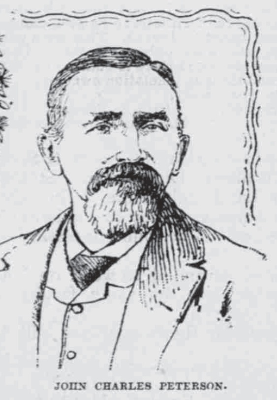
Diamond Head Charlie

“Ste-e-e-mer off Koko Head!”  (PCA, 1906)

“Before the telephone was invented, and long before the system was in use in Honolulu, we had the lookout station on Telegraph Hill, which by means of a semaphore arrangement communicated with a station on the building (downtown.)”

“Every merchant was supplied with the code, and whenever a schooner, a steamer, a mail packet, or a man of war, was sighted, the heart of the town knew it immediately.”  (Hawaiian Star, February 10, 1899)

Pu‘u O Kaimukī (aka “Kaimukī Hill”) was used as a sighting and signal station (using semaphore technology,) giving it the name “telegraph hill.”   It had broad view over the Pacific and line-of-sight to downtown Honolulu.  Back then, they used this vantage point to spot ships coming in, and then conveyed the news to Honolulu.

This is where John Charles Pedersen was first stationed.  Petersen was appointed lookout … by the then Minister of the Interior, Samuel G Wilder. The station was located at the top of Kaimuki Hill. (Evening Bulletin, September 27, 1907)

Semaphore towers used arms and blades/paddles to convey messages; messages were conveyed/decoded based on the fixed positions of these arms.  Reportedly, in 1857, a semaphore mechanism on Puʻu O Kaimukī, with large moveable arms, was attached to the top of a sixty-foot pole and used to signal to Honolulu.

The official receiving station from Kaimukī was on Merchant Street, but some have suggested other receiving stations at Kaʻahumanu Street and the foot of Nuʻuanu.

“When the telephone system got into working order the lookout station was moved to a position on Diamond Head which gave a view further along the channel, because it was no longer necessary for the station to be in full view of the city.” (Hawaiian Star, February 10, 1899)

Diamond Head was connected by telephone with the book store of Whitney & Robertson conducted in Honolulu Hale.  (Evening Bulletin, September 27, 1907)

Petersen’s regular weather reports (telephoned every evening promptly at 10 o’clock,) “Diamond Head – 10 pm – weather, hazy; wind, fresh, NE,” or calls with a ship sighting, “Ste-e-e-mer off Koko Head!” “gladdens the hearts of thousands of people every week.”  (Pacific Commercial Advertiser, January 29, 1906)

Following the call, HECO’s whistle would scream three long blasts, loud enough for all Honolulu to hear. This meant the ship would arrive in two hours, and people rushed to the harbor.

“All hands, including government officials of many grades and various departments, agents’ representatives, post office clerks, hotel and newspaper men, waterfronters, hackmen, messengers, shipping men, storekeepers, the large army of people “expecting friends,” and frequently Captain Berger and the Hawaiian Band, make haste to get down to the dock to ‘see the steamer come in.’” (Pacific Commercial Advertiser, January 29, 1906)

“For many years all Honolulu has depended on one man to announce the sighting of mail and freight steamers as well as the fleet of ‘windjammers.’  … ‘John Chas. Peterson, Keeper Diamond Head Signal Station,’ as he is designated in the directory.”  (Pacific Commercial Advertiser, January 29, 1906)

He was better known as Diamond Head Charlie.

Petersen was born in Gothenburg, Sweden. He came to the Islands eighteen years ago from San Francisco in the old schooner Lizzie Wight.   He left for a short while, returned and married a Hawaiian who died four months after her child was born. “The pledge of their union still lives to cheer the father’s heart.”

“His house is built on a rough slope of Diamond Head, facing the sea and from its position the faithful lookout commands an almost unlimited view of the broad Pacific. His business is to watch for incoming vessels and report them. … He watches with unfailing zeal, and it is very seldom that a vessel ever escapes his sharp eyes.”  (Pacific Commercial Advertiser, December 19, 1894)

“The great landmark on which he passes his time is well known to tourists and others, and it is eagerly watched for from the decks of incoming steamers. With the aid of glasses passengers can detect a small cottage, painted white, which is built on the side of the bleak extinct volcano.”

“Their home consists of bedrooms, a tiny bit of a pantry, and an observation room, from which Peterson scans the sea. On one side a large water tank stands, encased in wood; they must store the rain water or else go as far as James Campbell’s for the fluid.”

“In front of the cottage stands a flagpole eighty feet high, which is used for signaling. In a locker “Charlie” has a full complement of flags, and is proud of his belonging.”

“A large telescope stands in the observation room, which aids the eye to see a distance of at least thirty miles.  It is a powerful glass and when a vessel is eight miles away she does not appear to be more than 1000 yards distant. This telescope was presented to the lookout by Wm. G. Irwin and other merchants about town.”

“Peterson is on duty about seventeen hours every day, and divides his time between watching for vessels and cooking his meals. He has no servants, and of course must prepare his own food, which is done under great difficulties at times, as he has no kitchen.”

“He comes to town but once a month for his pay. While he is absent from his post, which is taken for the time being by a native, he usually purchases enough supplies to last him a month. His salary at present is $75 a month. He started in sixteen years ago at $50, and after a year’s time the sum was increased to $60.  He worked for twelve years for the last mentioned sum.”  (Pacific Commercial Advertiser, December 19, 1894)

“His glory began to grow dim when the lighthouse was erected at the Head and a keeper came to divide honors with him. Though he has constantly been an important factor to the business community and reported the ships appearing off the port, he became less a household word after the installation of the trans-Pacific cable.”    (Evening Bulletin, September 27, 1907)

“Each year since 1895 General Soper has made a Christmas collection for Charlie among the business men of the town. The largest sum was $440 collected in 1902. Charlie was a faithful man and the news of his death (September 27, 1907) caused widespread expressions of regret throughout the town.  (Evening Bulletin, September 27, 1907)

“For several weeks past Peterson was in the hospital and little hope was held for his recovery.  Close on the allotted three score years and ten, he now sighted that mysterious bark whose captain is called Death.”  (Pacific Commercial Advertiser, September 28, 1907)

© 2022 Hoʻokuleana LLC

Filed Under: Economy, Prominent People Tagged With: Diamond Head Charlie, John Charles Pedersen, Hawaii, Oahu, Kaimuki, Leahi, Diamond Head, Diamond Head Lighthouse

February 4, 2022 by Peter T Young Leave a Comment

Built in About an Hour

The Hawaiian Islands were formed as the Pacific Plate moved westward over a geologic hot spot.  Oʻahu is dominated by two large shield volcanoes, Waiʻanae and Koʻolau that range in age from two to four-million years old.

The younger volcanic craters are all less than 500,000 years old. They formed after Oʻahu had moved well off the hot spot and the main shield volcanoes had gone dormant for at least two-million years.

Scientists say Lēʻahi (Diamond Head) (one of these later eruptions) is a tuff cone, formed by hydromagmatic activity.  Tuff is a volcanic rock made up of a mixture of volcanic rock and mineral fragments. Wherever there are explosive volcanic eruptions you can expect to find tuff.  (SOEST)

A hundred years ago, Hawaiʻi missionary Reverend Sereno Bishop noted Diamond Head was made in less than an hour’s time and is “composed not of lava, like the main mountain mass inland, but of this soft brown rock called tuff.” (Bishop, Commercial Advertiser, July 15, 1901)

Others noted, “the duration of eruption of Diamond Head was of the order of five hours. The eruption may have been intermittent with interruptions sufficient to extend the whole period of activity to as much as five days, but probably not more.”    (Wentworth, Bishop Museum, 1926)

“Volcanic eruptions may be distinguished into two classes, the effusive and the explosive. In the former the molten rock is poured out and covers the mountain slopes with great floods.”

“If you look up at the sides of yonder ravines (on the Koʻolau mountains,) which the rainstorms of many hundred thousands of years have worn out of the original dome-shaped mountain, you will see the back edges of the ancient lava streams lying in layers.”

“The tuff cones are entirely different, and are produced by very brief and sudden explosive eruptions.  The tuff was violently shot high aloft into the air in the form of superheated mud. This hot mud cooled and thickened by the expansion of its water and its partial escape as steam before reaching the ground.”

“It hardened and cemented as it fell, though still liquid enough to form in thin layers or laminations as we see it lying around us at the base of the hill. … The tuff-fountain escaping from its confinement, at once expanded and spread out like a vast tree.”

“Here at Diamond Head, which is one mile in diameter, the bulk of the mud spread out half a mile in all directions before ending its fall. Thus a very exact circular ring was piled up of one mile in diameter. There was, however, another influence, that of a violent easterly-wind which deflected the entire fountain westward”.

“The wind also acted with especial force upon the highest part of the fountain, flinging and piling it up on the western side of the crater in a lofty cone. A large part of that cone has been weathered away by the impact of rainstorms upon the soft rock; but it still stands in a peak some 200 feet higher than the main run.”

“The vent or point of issue of the tuff-fountain must have been at the lowest point of the interior, where lies the present pond of water.”  (Bishop, Commercial Advertiser, July 15, 1901)  (The same series of eruptions produced Punchbowl and Koko Head Crater.)

Somewhat more than half of the craters of southeast Oahu are arranged in linear groups, those dominated by the craters Tantalus, Diamond Head, and Koko Crater.  In the Diamond Head group is the main Diamond Head vent, Kaimuki crater and Mauʻumae crater.

(A cinder cone is a volcanic cone built almost entirely of loose volcanic fragments called cinders or pumice that accumulate around and downwind from a vent.)

(Cinders are glassy and contain numerous gas bubbles “frozen” into place as magma exploded into the air and then cooled quickly.)  (USGS)

© 2022 Hoʻokuleana LLC


Filed Under: General, Place Names Tagged With: Hawaii, Oahu, Koolau, Sereno Bishop, Leahi, Diamond Head

  • 1
  • 2
  • 3
  • 4
  • Next Page »

Images of Old Hawaiʻi

People, places, and events in Hawaiʻi’s past come alive through text and media in “Images of Old Hawaiʻi.” These posts are informal historic summaries presented for personal, non-commercial, and educational purposes.

Info@Hookuleana.com

Connect with Us

  • Email
  • Facebook
  • LinkedIn
  • Twitter
  • YouTube

Recent Posts

  • Women Warriors
  • Rainbow Plan
  • “Pele’s Grandson”
  • Bahá’í
  • Carriage to Horseless Carriage
  • Fire
  • Ka‘anapali Out Station

Categories

  • Hawaiian Traditions
  • Military
  • Place Names
  • Prominent People
  • Schools
  • Sailing, Shipping & Shipwrecks
  • Economy
  • Voyage of the Thaddeus
  • Mayflower Summaries
  • American Revolution
  • General
  • Ali'i / Chiefs / Governance
  • Buildings
  • Missionaries / Churches / Religious Buildings

Tags

Albatross Al Capone Ane Keohokalole Archibald Campbell Bernice Pauahi Bishop Charles Reed Bishop Downtown Honolulu Eruption Founder's Day George Patton Great Wall of Kuakini Green Sea Turtle Hawaii Hawaii Island Hermes Hilo Holoikauaua Honolulu Isaac Davis James Robinson Kamae Kamaeokalani Kamanawa Kameeiamoku Kamehameha Schools Lalani Village Lava Flow Lelia Byrd Liliuokalani Mao Math Mauna Loa Midway Monk Seal Northwestern Hawaiian Islands Oahu Papahanaumokuakea Marine National Monument Pearl Pualani Mossman Queen Liliuokalani Thomas Jaggar Volcano Waikiki Wake Wisdom

Hoʻokuleana LLC

Hoʻokuleana LLC is a Planning and Consulting firm assisting property owners with Land Use Planning efforts, including Environmental Review, Entitlement Process, Permitting, Community Outreach, etc. We are uniquely positioned to assist you in a variety of needs.

Info@Hookuleana.com

Copyright © 2012-2024 Peter T Young, Hoʻokuleana LLC


Loading Comments...