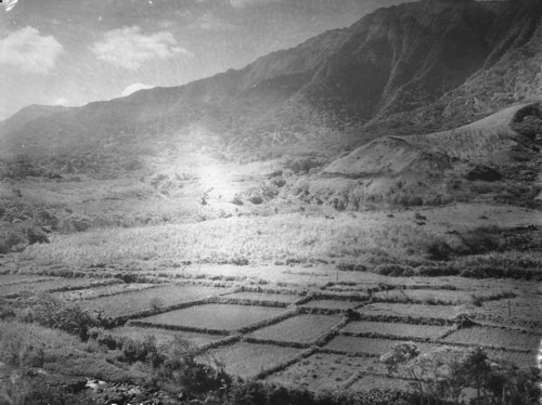
According the research and reporting by noted archaeologists, there were three main technological advances resulting in food production intensification in pre-contact Hawai‘i: (a) walled fishponds, (b) terraced pondfields with their irrigation systems and (c) systematic dry-land field cultivation organized by vegetation zones.
The lo‘i kalo (terraced pondfields), a technological invention by Hawaiian Polynesians, was the development of their extended stone-faced, terraced pondfields (lo‘i) and their accompanying irrigation systems (‘auwai) for the intensive cultivation of wetland taro (kalo.)
“The ground within the lo‘i [was] broken by means of a mattock or ‘ō‘ō. ‘Ō‘ō designates the tool largely used by the natives in cultivation in preference to the implements of modern farmers.”
“The ‘ō‘ō closely resembles in its manner of use the sharpened stick of kauila or other hard wood, used by them previous to their knowledge of iron. The first metal ‘ō‘ō were blubber spades brought here by the whaling-vessels.”
“The boundaries of a lo‘i depend largely upon the shapes of adjacent lo‘i, and upon the relative positions of the various levels along which the irrigation water is to run.”
“The embankments of the lo‘i are built up of stones and clods of earth. These embankments were commonly known as kuāuna. … Names less frequently used, for the embankments of the lo’i, were ika, kaika and kuaio.”
“In former times the kuāuna between the lo‘i was much wider than at present. They served as a convenient place on which to throw the grass and weeds pulled up from the lo’i until they were wanted as fertilizer.”
“Often sugar-cane, banana plants, or the ki plant, grew luxuriantly on these kuāuna. As kalo land increased in value the kuāuna naturally shrunk in width, and with the advent of the Chinese planter they were often made too narrow to walk upon dry shod. Ho‘ohu meant to run along the bank of a kalo patch.”
“The side or border of an upland kalo field was called iwi. Iwi means a bone, a name applied to the long rows of stones gathered from the mo‘o ‘āina or to a narrow strip of upland to be planted with kalo or potatoes.”
“These iwi always run in the direction of the slope from the sea towards the mountains. As they coincide with the division lines between the fields, the term iwi ‘āina came to mean the boundaries between such lands, and is a term often used in that sense in the descriptions in the Hawaiian language on record in the Land Office.”
“If necessary considerable soil is taken from the lo‘i and put upon the embankments so that the surface of the lo’i will be below the level of the water supply. La‘ola‘o la‘au were the little sticks put down to sustain the kuāuna or bank of the kalo patch.”
“Water is then turned in and is soon soaked up by the broken soil. While the ground is still wet it is dug up or plowed several times. The Hawaiians call this labor mahi-ai. (The Hawaiian Forester and Agriculturist, Volume 11, 1914)
The terraces were irrigated with water brought in ditches (‘auwai) from springs and streams high in the valleys, allowing extensive areas of the valleys to be cultivated.
The irrigation ditches and pondfields were engineered to allow the cool water to circulate among the taro plants and from terrace to terrace, avoiding stagnation and overheating by the sun (which would rot the taro tubers).
An acre of irrigated pondfields produced as much as five times the amount of taro as an acre of dryland cultivation. Over a period of several years, irrigated pondfields could be as much as 10 or 15 times more productive than unirrigated taro gardens, as dryland gardens need to lie fallow for greater lengths of time than irrigated gardens.
In addition, walled pondfields not only produce taro, but were also used to raise an additional source of food, freshwater fish (primarily the Hawaiian goby (‘o‘opu nakea) and certain kinds of shrimp (‘opae)).
Captain George Vancouver visited O‘ahu in 1792 and wrote about the taro gardens in tine Waikīkī-Kapahulu-Mo‘ili‘ili-Manana complex that he observed:
“Our guides led us to the northward through the village [Waikīkī], to an exceedingly well-made causeway, about twelve feet broad, with a ditch on each side.”
“This opened to our view a spacious plain … the major part appeared divided into fields of irregular shape and figure, which were separated from each other by low stone walls, and were in a very high state of cultivation.”
In 1815, the explorer Kotzebue added to these descriptions by writing about the gardens and the artificial ponds that were scattered throughout the area:
“The luxuriant taro-fields, which might be properly called taro-lake, attracted my attention. Each of these consisted of about one hundred and sixty square feet, forms a regular square, and walled round with stones, like our basins.”
“This field or tank contained two feet of water, in whose slimy bottom the taro was planted, as it only grows in moist places. Each had two sluices. One to receive, and the other to let out, the water into the next field, whence it was carried farther.”


Leave your comment here: