The basis for the name was conceived during World War I when German soldiers gave the United States Marines opposing them in battle the name “Devil Dogs,” because of their battlefield accomplishments and valor of the Marines [and “never give up” spirit]. (Devil Pups)
The Marines who organized this youth citizenship program chose the term “Devil Pups” to describe the quality of teen who can complete this program. (Southern Utah Devil Pup)
“Devil Pups are [14] – to 17-year-old high school students from all over California [and, now, beyond] who assemble each summer here for 10-day physical fitness and citizenship training sessions. Sometimes the Pups are referred to as junior Marines.”
“They also are taken to Marine training sessions and to firing ranges, where they observe weapon firing, tanks, artillery and aerial firing. But otherwise they have little contact with firearms.” (LA Times, Advertiser, Aug 24, 1970)
‘‘The Idea caught on and in the summer of 1954 we were able to send 30 boys to Camp Pendleton for a one-week trial program of training in physical fitness and respect for authority and the flag.’” (San Bernardino County Sun, Aug 20, 1982)
“Duncan Shaw, a Los Angeles Marine Corps reserve officer [and] president of the Devil Pups since it was inaugurated, said, ‘The idea started here when we read of some high school boys who had torn the American flag, kicked it around and generally behaved like idiots.’”
“‘We thought maybe we could do something about it in a small way by starting a health education and citizenship program for teen-agers. … Since then the program has grown and has been most successful.’”
“‘We have liaison officers in each town of any size who work with the Boy Scouts, the Salvation Army and other groups and clubs to select boys for the program. A boy, however, does not have to belong to a club to get on the program so long as his parents’ permission is given.’”
“‘We are not trying to run a juvenile delinquency school. Any deserving boy is welcome. We simply put them through a regimented program of health education and citizenship, try to develop a competitive spirit and give them lectures on the American flag and what it means to be an American.’” (Evening Vanguard, Nov 18, 1964)
“One of the more enthusiastic supporters of the Devil Pups program is Richard Charest, 16, of Anaheim, Calif., who was impressed by the physical fitness aspects. ‘I think we ought to get more of these idiots off the streets – who are fouling up on drugs – and involve them in a program like this.”
“This would clean up the United States. There is a lot of garbage out there in the streets and we ought to clear them out by involving them and teaching them about citizenship and the flag,’ he said.” (LA Times, Advertiser, Aug 24, 1970)
“‘We had considerable trouble with the Devil Pups that first year. Nearly all of them were juvenile delinquents and weren’t about
to be changed in one week. They almost tore their building apart.’”
“‘Today’s Devil Pups are the pick of the crop, from all parts of the community, to be sure, but to be accepted, they must show their interest in the program. Then they are interviewed and and tested physically before they are sent here to camp,’ [Maj. Tom Vener, USMCR] said.” (San Bernardino County Sun, Aug 20, 1982)
The program is not a ‘mini boot camp’ or recruiting organization for the Marine Corps. The 10-day program is a combination of outdoor physical exercises, inspirational classroom lectures and demonstrations of Marine Corps operations.
The activities during both increments are overseen by our Encampment Commander and his executive staff (employees of Devil Pups, Inc.). Each day, the running, diving, and hiking exercises are balanced with inspiring classroom sessions. The “Role Model” classroom segments are conducted by an assortment of board members, veterans, and Devil Pups alumni. (Devil Pups)
“Since 1954 we have not asked our participants to pay tuition to attend our program. We spend the entire year raising the funds we need which go towards the cost of the camp including counselor fees, food, transportation, clothing, insurance, fundraising, office supplies, and more.”
“Devil Pups, Inc. raises 100% of the funds for 100 youth to attend our camp every year, which is budgeted at a rough cost of $975 per Pup. We want every Pup not to be hindered from acceptance due to financial reasons, and have been doing so since we started 70 years ago. We want them all to have an equal opportunity to participate.” (Devil Pups)
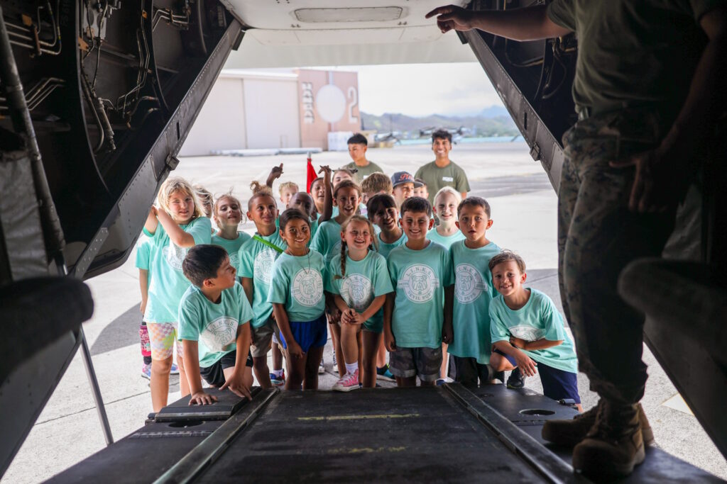
For at least the last couple of years including on August 16, 2024, “The [MCBH Lifestyle Insights, Networking, Knowledge, and Skills (LINKS) program of the] Marine Corps Family Team Building hosted the [Little] Devil Pups workshop, which included a miniature physical fitness test, water gun shooting range, vehicle and aircraft tours, and a readiness class.”
This was for children with parents living or working at MCBH; the MCBH included a Homecoming Run, a resource fair and homecoming sign making.
“The Devil Pups Youth Program For America is all about helping young boys and girls build confidence and learn about responsibility while taking on new challenges.” (U.S. Marine Corps by Lance Cpl. Samuel Estridge)