Several have asked about historical information on Lahaina and West Maui. Here is a repeat of something I posted a while ago – its focus is on West Maui.
West Maui was considered a ‘window to the world’ because this area has seen the comings and goings of rival chiefs, kings, missionaries, whalers, government officials, the military, sugar and pineapple plantation owners, early labor immigrants, celebrities and travelers for centuries.
This ‘window’ is a metaphor. As a ‘window to the world,’ the stories of West Maui give a bigger perspective of the world, than we would otherwise have, and helps us to expand our view and broaden our understanding of the world.
History tells us much about a community – what it is and where it has come from. West Maui has a rich history dating back to the times of: Pre-contact Hawaiʻi; Hawaiian Monarchy; American Protestant Missionaries; Whaling industry; Sugar and Pineapple Plantations; and Evolution of the West Maui Community.
Each successive passage of an era has added to the cultural richness of the community. And through the tireless efforts of numerous organizations and individuals in the community, much has been done to preserve the historic character of West Maui town and to restore historic sites.
The island of Maui is divided into twelve moku; Kāʻanapali, Lāhainā, Wailuku, Hāmākuapoko, Hāmākualoa, Koʻolau, Hāna, Kīpahulu, Kaupō, Kahikinui, Honuaʻula and Kula. Two of these, Kāʻanapali and Lāhainā make up West Maui.
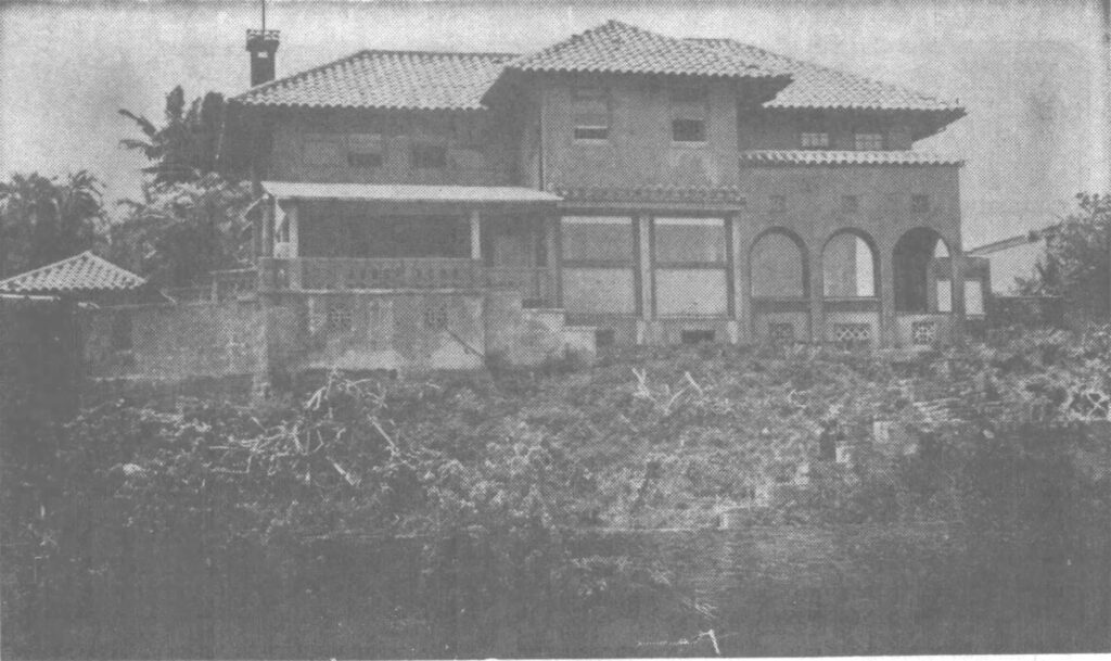
Probably there is no portion of our Valley Isle, around which gathers so much historic value as West Maui. It was the former capital and favorite residence of kings and chiefs.
After serving for centuries as Royal Center to ruling chiefs, West Maui was selected by Kamehameha III and his chiefs to be the seat of government; here the first Hawaiian constitution was drafted and the first legislature was convened.
Hawai‘i’s whaling era began in 1819 when two New England ships became the first whaling ships to arrive in the Hawaiian Islands. Over the next two decades, the Pacific whaling fleet nearly quadrupled in size and in the record year of 1846, 736-whaling ships arrived in Hawai’i.
Although Honolulu was originally the port most favored by the whalers, West Maui often surpassed it in the number of recorded visits, particularly from about 1840 to 1855.
Lāhainā Roads, also called the Lāhainā Roadstead is a channel between the islands of Maui and Lānai (and to a lesser extent, Molokai and Kahoʻolawe) making it a sheltered anchorage.
The central location of the Hawaiian Islands between the continent and Japan whaling grounds brought many whaling ships to the Islands. Whalers needed food and the islands supplied this need from its fertile lands.
Between the 1820s and the 1860s, the Lāhainā Roadstead was the principal anchorage of the American Pacific whaling fleet. One reason why so many whalers preferred West Maui to other ports was that by anchoring in a roadstead from half a mile to a mile from shore they could control their crews better than when in a harbor.
Another factor to affect the change, growth and social structure of West Maui was the arrival of the first missionaries in the islands during 1820.
The first missionaries to be established at Lāhainā, the Rev. CS Stewart and the Rev. William Richards, arrived in 1823. They came at the request of Queen Mother Keōpūolani, who moved to live in Lāhainā that year.
The great event of 1823 was the death of Keōpūolani at Lāhainā. Within an hour before “joining the Great Majority” she had been baptized as a Christian, an occurrence which proved a great stimulus to increasing the influence of the missionaries. King Kaumuali’i of Kauai, at his special request, was buried beside Keōpūolani in 1824. (NPS)
In 1831, classes at the new Mission Seminary at Lahainaluna (later known as Lahainaluna (Upper Lahaina)) began. The school was established by the American Board of Commissioners of Foreign Missions “to instruct young men of piety and promising talents” (training preachers and teachers.) It is the oldest high school west of the Mississippi River.
Per the requests of the chiefs, the American Protestant missionaries began teaching the makaʻāinana (commoners.) Literacy levels exploded.
From 1820 to 1832, in which Hawaiian literacy grew by 91 percent, the literacy rate on the US continent grew by only 6 percent and did not exceed the 90 percent level until 1902 – three hundred years after the first settlers landed in Jamestown – overall European literacy rates in 1850 had not been much above 50 percent.
Centuries ago, the early Polynesian settlers to Hawaiʻi brought sugar cane with them and demonstrated that it could be grown successfully.
It was not until 1823 that several members of the West Maui Mission Station began to process sugar from native sugarcanes for their tables. By the 1840s, efforts were underway in West Maui to develop a means for making sugar as a commodity.
Starting in the 1850s, when the Hawaiian Legislature passed “An Act for the Governance of Masters and Servants,” a section of which provided the legal basis for a contract-labor system, labor shortages were eased by bringing in contract workers from Asia, Europe and North America.
It is not likely anyone then foresaw the impact this would have on the cultural and social structure of the islands. The sugar industry is at the center of Hawaiʻi’s modern diversity of races and ethnic cultures. Of the nearly 385,000-workers that came, many thousands stayed to become a part of Hawai‘i’s unique ethnic mix. Hawai‘i continues to be one of the most culturally-diverse and racially-integrated places.
Pioneer Mill Company was one of the earliest plantations to use a steam tramway for transporting harvested cane from the fields to the mill. Cane from about 1000‐acres was flumed directly to the mill cane carrier with the rest coming to the mill by rail. (The Sugar Cane Train is a remnant of that system.)
In 1859, an oil well was discovered and developed in Titusville, Pennsylvania; within a few years this new type of oil replaced whale oil for lamps and many other uses – spelling the end of the whaling industry.
By 1862, the whaling industry was in a definite and permanent decline. The effect of West Maui was striking. Prosperity ended, prices fell, cattle and crops were a drag on the market, and ship chandleries and retail stores began to wither.
Historically Maui’s second largest industry, pineapple cultivation has also played a large role in forming Maui’s modern day landscape. The pineapple industry began on Maui in 1890 with Dwight D. Baldwin’s Haiku Fruit and Packing Company on the northeast side of the island.
West Maui’s roots in the historic pineapple industry began in 1912, when of Honolua Ranch manager, David Fleming began growing pineapple there; almost overnight the pineapple industry boomed.
The ranch was soon renamed Baldwin Packers; at one time they were the largest producer of private label pineapple and pineapple juice in the nation.
One of the first hotels in West Maui was the Pioneer Hotel – founded in 1901. George Freeland arrived in the Lāhainā roadstead on a ship that had just come from a long voyage through the south seas; he noted a need for a hotel.
It remained the only place for visitors to stay on Maui’s west side until the early-1960s. Tourism exploded; West Maui is a full-fledged tourist destination second only to Waikīkī.
Lāhainā’s Front Street, offering an incredible oceanfront setting, people of diverse cultures, architecture and incredible stories of Hawaiʻi’s past, was recognized as one of the American Planning Association’s 2011 “Great Streets in America.”
The following link is to a larger discussion on West Maui – it was prepared a few years ago, before the fires.
Click HERE to view/download for more information on West Maui’s place in the Islands and world.
To see and read about the many structures that were lost in the Lahaina fire, I encourage you to download an App developed by the Lahaina Restoration Foundation that was put together as a ‘Walking Tour’ through Lahaina (you will see images and information on the pre-fire structures):
https://lahainarestoration.org/lahaina-historic-trail/
The tragic fire in Lahaina destroyed many of the physical structures of the community. Some of the historic buildings may be rebuilt; something else will take the place of others.
But the fires did not take away the memory we share of this area. Do what you can to help those that have been impacted and share your memories of West Maui and Lahaina. Maui No Ka Oi (Maui is the best).
-WC")


-1848")


")


")

")
")