Images of Old Hawaiʻi

  • Home
  • About
  • Categories
    • Ali’i / Chiefs / Governance
    • American Protestant Mission
    • Buildings
    • Collections
    • Economy
    • Missionaries / Churches / Religious Buildings
    • General
    • Hawaiian Traditions
    • Other Summaries
    • Mayflower Summaries
    • Mayflower Full Summaries
    • Military
    • Place Names
    • Prominent People
    • Schools
    • Sailing, Shipping & Shipwrecks
    • Voyage of the Thaddeus
  • Collections
  • Contact
  • Follow

January 21, 2023 by Peter T Young Leave a Comment

Growing Pains

Oʻahu is about 382,500-acres in size; the district of Puna on the island of Hawaiʻi is about 320,000-acres in size – almost same-same.

According to the 2020 census, Oʻahu has about 984,000-people and Puna has about 46,800.  That means there are less than a half-acre per person on Oʻahu and about 7-acres per person in Puna.

For some, it sounds like optimal living; and, many are moving to the Big Island to enjoy this rural lifestyle.

Open spaces with room to roam, it sounds kind of like the Wild West.  And, for some, that’s its nickname, however, not with the same context.

Wait, there’s more.

Between 1958 and 1973, more than 52,500-individual lots were created.  There are at least over 40 Puna subdivisions. Geographically, these subdivisions are sometimes as big as cities.

For example, Hawaiian Paradise Park has over 8,800 building lots and is reportedly the second largest private subdivision in the United States.  It is over 4-miles long and nearly 3½-miles wide.

Back then, they plotted out the subdivisions in cookie-cutter residential/agricultural lots across a grid, with very little space for other uses (such as parks, open space, government services, regional roads … the list goes on and on.)

To add insult to injury, most subdivision lots are accessed by private, unpaved roads. The streets generally lack sidewalks and lighting, and do not meet current County standards in terms of pavement width, vertical geometrics, drainage and other design parameters.

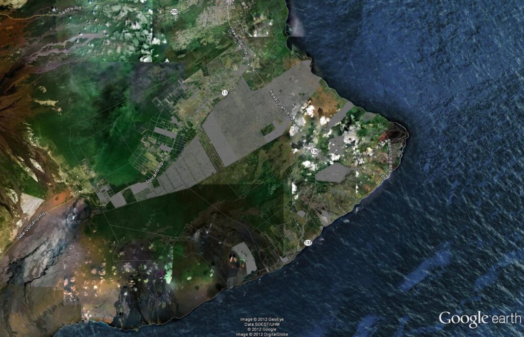
There are only two main roads to move the people in the district in and out – one (Route 130 – Keaau-Pahoa Road) goes into Pahoa to Kalapana; the other (Route 11 – Volcano Highway) serves the lots up in the Volcano area.

Most lots rely on individual catchment systems (captured off the roof and rainfall stored in water tanks) supplemented with private delivery trucks for drinking water.  None of the subdivisions have central sewer systems. Large sections of some subdivisions are off the power grid.

Oh, and one more thing, about 6,400 subdivision lots lie in the highest lava hazard zone and over 500 of these are exposed to additional risks from subsidence, tsunami and earthquakes.

That’s not just hazards noted on a map; thousands of these lots have been covered by lava flows or have been rendered unbuildable by shoreline subsidence over the years.

While most of these subdivisions are on agricultural-zoned lands, the actual use of developed lots is predominantly residential.

At the time these subdivisions were approved, the Puna district was sparsely populated and, with the exception of a sugar plantation and a small-scale visitor attraction at the volcano, which had not yet been developed as a national park, there was little economic activity in the area.

Shortly after the approval of the first of these subdivisions, Hawai‘i was admitted as the 50th state. That event, coinciding with jet travel, spurred increased investment in the Islands.

To prevent the excesses of land speculation, Hawai‘i adopted the first State Land Use Law in the nation in 1961.

Most of the Puna district was placed in either the Conservation District or the Agriculture District when formal boundaries were established in 1964, and this somewhat served to abate the number of subdivision applications.

However, it wasn’t until the County adopted a subdivision ordinance in 1973, setting more rigorous lot size and infrastructure standards, that large subdivisions with minimal services were effectively discouraged.

In the first decade or so following the creation of the non-conforming subdivisions, lot sales were fairly brisk, but there was little lot development.

In the 1970 Census, the recorded population of the Puna District was only 5,154-residents, most of whom lived in the older settlements of Kea‘au, Pāhoa and Volcano.

That was then, over the years the population exploded, doubling to 11,751 in 1980, then up another 10,000 by 1990 (to 20,781,) and another 11,000 by 2000 (to 31,335,) and another 14,000 by 2010 (to 45,326) to the 2020 population of about 46,800.

Population growth has worn on the minimal infrastructure, as well as people’s patience.

Today, folks in Puna are living with the lack of planning and regulatory control over the subdivision bonanza days.  But, they do benefit from lower sales prices (associated with the general lack of facilities and the huge availability.)  Some say you are getting what you pay for.

This region is finally undergoing some short and long-range planning.  And, there are attentive council members seeking to have Puna get its fair share.

Depending on your perspective, addressing the issues in this region today is either a planner’s nightmare or a planner’s dream.  This is an area where I would love to get involved – for me, challenges create opportunities.

The image notes the individual parcels within the Puna district (overlaying the Google Earth image.)  At this scale, many of the lots are not discernible – the fully gray areas indicate smaller lot residential uses, with no (or very limited) park space – where you can just see between the lines, these are 1-5 acre parcels.

© 2023 Hoʻokuleana LLC

Filed Under: Place Names, Economy Tagged With: Hawaii, Puna, Subsidence, Hawaii County, Lava Hazard

January 20, 2023 by Peter T Young Leave a Comment

Merry or Merrie?

Today, we typically reference King David Kalakaua as the ‘Merrie Monarch;’ and most also say it was his nickname used by those outside of Hawai‘i.  Most suggest it was inspired by the king’s love of music, parties and fine food and drinks.  Yet, it is not clear why we spell ‘Merry’ that way.

It is probably coincidental, but about the same time Kalakaua was ruling in the Islands, there were numerous articles written about King Charles II, who had been ruling about 200-years earlier in England.  Charles was also referred to as the “Merry Monarch of England,” or simply, the “Merry Monarch.”

Charles II (born May 29, 1630, London—died February 6, 1685, London) was king of Great Britain and Ireland (1660–85).  He was restored to the throne after years of exile during the Puritan Commonwealth.

The years of his reign are known in English history as the Restoration period. His political adaptability and his knowledge of men enabled him to steer his country through the convolutions of the struggle between Anglicans, Catholics, and Dissenters that marked much of his reign. (Britannica)

“Charles Stuart the 2nd of England who lived an “eventful life” with “wild orgies” in “his depraved and dissolute court” was referred to in England as the “merry monarch.” (It was sometimes spelled ‘merrie monarch.’)

He was described as “a man of great and varied talents, a heartless libertine, sunk in vice and debauchery, and soddened with lust”.  (The Chelmsford Chronicle (Chelmsford Essex, England, January 13, 1860)

It is not clear if Charles II was referred to as the Merry Monarch during his reign; Hawai‘i’s King Kalakaua was also referred to as a Merry Monarch.  However, the first reference of such appears to be in news accounts of his death. (He died January 20, 1891.)

Several, primarily Mid-Western, newspapers on the continent ran identical stories with the heading that stated “He Was a Merry Monarch” The lead line of the story was “King David of Hawaii is dead.”  (January 29, 1891)

Later, the Honolulu Advertiser, in writing about the King in an October 23, 1901 article, noted, “when the merry monarch came to the throne a new nobility was created”.

In reference to Kalakaua, though, we call him ‘Merrie’, as noted above and below, it was not always so.

Early newspaper references to a Kalakaua nickname were all, effectively, using ‘Merry.’

In 1903, the Pacific Commercial Advertiser (PCA) referenced, “King Kalakaua, the merry monarch.”  The next year, he was again referred to as ‘the merry monarch.’

Later, in 1904, the PCA reported on the christening of the infant son of Prince and Princess Kawananakoa where the paper stated, “the name of the ‘Merry Monarch of Hawaii’ was revived, for the young Prince will bear the name of David Kalakaua II.”

Later, the Honolulu Advertiser referred to Kalakaua as the “Merry Monarch of the Paradise of the Pacific.”  Kuykendall’s 3rd and final volume, describing the “Kalakaua Dynasty,” says that it “covers the colorful reign of King Kalakaua, the Merry Monarch.”

Even the festival that bears the nickname is not clear, nor consistent, with the spelling …

The first hula festival (held in 1964) that bore Kalakaua’s nickname was called the ‘Merry Monarch Festival’.  In anticipation of the event, the Hawaii Tribune Herald referred to “the first Merry Monarch Festival to be held in Hilo next April.”

Newspaper reports note that, “A purpose of the Merry Monarch Festival, a special project of the Hawaii Island Chamber of Commerce, is to develop an attraction that will draw visitors here during tourism’s slack period of the year.” (Hawaii Tribune Herald, March 31, 1964)

A later Hawaii Tribune Herald story (September 29, 1963) noted, “A Merry Monarch Festival designed to bring back for a brief period the colorful years if King Kalakaua will be held in Hilo next April, it was announced today by George Naope, promotor of activities for the County.”

In announcing that the Hawaii Island Chamber of Commerce had agreed to sponsor the “Merry Monarch Festival,” chairman Gene Wilhelm said, “the Merry Monarch Festival, named for Hawaii’s King Kalakaua, who reigned from 1874 to 1891, is planned for an annual event during the first week following Easter.” (Hawaii Tribune Herald, January 10, 1964)

in the early years, in addition to an annual parade and hula, there were a variety of other programs associated with the festival.

Men competed in a Kalakaua look-alike contest; quarter- and semi-finals of a sideburns-mustache contest at Mooheau Park.  (If he was married, the festival gave a gift certificate to “The Most Understanding Wife” (Hawaii Tribune Herald)

A couple of athletic competitions also took place. Single riders and relay teams competed in the Merry Monarch Festival Bicycle Pete Beamer Derby and rode bicycles from the Kamehameha Statue in Kohala, headed through Waimea, along the Hamakua Coast and ended up at Kalakaua Park in Hilo.  The winner of the 85-mile race received a trophy and $25.

Reminiscent of the old days of Hawai‘i when relays of the swiftest runners carried fresh fish to the chiefs, the festival had a 4-mile relay race through Hilo (starting and finishing at Mo‘oheau Park).  The relay runners used mullet as ‘batons.’

Another of the early festival activities was a Treasure Hunt.  Hunters were to dig up a buried box containing a Kalakaua medallion, redeemable for a cash prize, that was buried in a secret location.

“Samuel Clemens Moke, King Kalakaua’s emissary who pays daily visits to the Tribune Herald” provided cryptic clues on the treasure’s location.  These were published in the Hawai‘i Tribune Herald.

In reporting on its 50th anniversary, The Hawaii Tribune Herald noted that, “Andres Baclig, the county bandmaster in 1964, composed a number called the ‘Merry Monarch Festival March.’”

“The song, which was received with much acclaim, was presented at the Mooheau Bandstand on April 2, 1964, and it was a spirited number, featuring ‘lots of trombones and baritones.’”

In a report on planning for the 5th annual festival in the Honolulu Advertiser (December 24, 1967), it was reported that, “The largest planning committee ever set up for a Hilo Merry Monarch Festival is at work on the fifth annual festival”.

The ‘Merry’ name was used at least until 1969.

However, the 1977 program for the festival was a bit ambidextrous. The program was titled ‘Merrie Monarch Festival,’ but text on its initial pages, noted, “Hilo’s Merry Monarch Festival is named for Kalakaua who was Hawaii’s Merry Monarch.”

In 1971, the first competitive Merrie Monarch contest took place at the Hilo Civic Auditorium.  In 1979 the festival moved to the Edith Kanaka‘ole Tennis Stadium, where it has been held ever since.

In the late-1970s, newspaper reporting noted that performing at Hulihee Palace was the ‘Merry Monarchs Hawaiian Glee Club,’ “the foremost all male Hawaiian language singing group in the Islands (December 12, 1977).  A similar concert to celebrate the birthday of “Hawaii’s Merry Monarch, Kalakaua” was held that year at the Waikiki Shell.

Today, the King and Festival are referred to as the ‘Merrie Monarch.’  It is not clear when and why the nickname or the festival name changed from ‘Merry’ to ‘Merrie’.  However, the festival remains the premier hula competition.

© 2022 Ho‘okuleana LLC

Filed Under: General, Ali'i / Chiefs / Governance, Prominent People, Economy Tagged With: Kalakaua, Hula, Merrie Monarch, Festival

January 19, 2023 by Peter T Young Leave a Comment

Whigs and Tories

Parliament (from Old French: parlement; Latin: parliamentum) is the original legislative assembly of England, Scotland, or Ireland and successively of Great Britain and the United Kingdom.  The British Parliament consists of the sovereign, the House of Lords, and the House of Commons.

Originally meaning a talk, the word was used in the 13th century to describe after-dinner discussions between monks in their cloisters.

In the 13th century, King Edward I (1272–1307) called joint meetings of two governmental institutions: the Magnum Concilium, or Great Council, comprising lay and ecclesiastical magnates, and the Curia Regis, or King’s Court, a much smaller body of semiprofessional advisers.

The parliament called in 1295, known as the Model Parliament and widely regarded as the first representative parliament, included the lower clergy for the first time as well as two knights from each county, two burgesses from each borough, and two citizens from each city.

Early in the 14th century the practice developed of conducting debates between the lords spiritual and temporal in one chamber, or “house,” and between the knights and burgesses in another.

Eventually, under King Henry VI (reigned 1422–61; 1470–71), the assent of both the House of Lords (a body based largely on heredity) and the House of Commons was also required.

Strictly speaking, there were, and still are, three houses: the king and his council, the lords spiritual and temporal, and the commons.  (Britannica)

In January 1679 Charles II dissolved what was known as the Cavalier Parliament, which he had first summoned in May 1661, and summoned another one for May 1679. For the last years of the Cavalier Parliament a loose grouping of Members, known as the Country party, had opposed the Court’s influence in Parliament, particularly its attempts to secure votes through bribes and patronage.

From 1679, in the wake of the Popish Plot allegations, a section of this opposition took on a more obviously religious dimension. Those who fought most vigorously against the Court’s corruption and its foreign policy also strongly opposed the Church’s persecution of Protestant Nonconformists and the possibility of the Catholic Duke of York’s succession to the throne.

This group became known as the ‘Whigs,’ and they showed their flair for organization and propaganda through their overwhelming victories in the elections for the three ‘Exclusion Parliaments’ of 1679-81. In reaction, a ‘Tory’ ideology had developed by 1681 which equally loudly supported the monarchy and the Church. (UK Parliament)

“Whig” and “Tory” are political party labels that have been in use in England since around 1681 – and their specific meaning has varied somewhat with changing historical circumstances.

In the late 17th century Toryism became identified with Anglicanism and the squirearchy (landowners collectively, especially when considered as a class having political or social influence) and Whiggism with the aristocratic, landowning families and the financial interests of the wealthy middle classes. (Britannica)

Thomas Babington Macaulay opined that the political labels “Whig” and “Tory” are “two nicknames which, though originally given in insult, were soon assumed with pride, which are still in daily use, which have spread as widely as the English race, and which will last as long as the English literature”.  (George Mason University)

As political labels, the terms derive from the factional conflict of the Exclusion Crisis (1679-81), Whigs being supporters of Exclusion (of the Catholic James, Duke of York, brother of the king and next in line for the English throne) and Tories being their Royalist opponents.

By extension, then, the Whigs were seen as asserting the primacy of Parliament over the monarch, while the Tories were seen as asserting the inverse.

Through the rest of the seventeenth and the early part of the eighteenth centuries, the terms “Whig” and “Tory” would continue to carry the weight of the Civil War conflicts even as the two factions came to be defined and redefined, first, in the Exclusion Crisis itself, then, in the aftermath of the Revolution of 1688.

British Parliament and the American Revolution

For much of the 17th century Parliament had little direct involvement in the growing colonies in America.  Most had royal origins – through either chartered trading companies (such as the Virginia Company), royal grants to favorite individuals (William Penn’s Pennsylvania) or direct royal control (Barbados).

Parliament’s largely hands-off policy towards America later became known as salutary neglect. (UK Parliament)  Due to debt from the French and Indian War Parliament started to tax the colonies by raising import duties on certain goods. The colonists continued to insist that they could not be taxed by the British Parliament without proper representation, even indirectly by customs duties.

Then on December 16, 1773 a group of protesters in Boston boarded a ship and dumped £10,000 worth of tea in the harbor, an event immortalized in the United States as the Boston Tea Party.  In angry response, Parliament passed in 1774 a series of punitive measures, known in America as the Intolerable Acts, which closed Boston harbor and strengthened the power of the royal governor over the rebellious Massachusetts legislative assembly.

The crisis of 1774 soon tipped over into armed confrontation between British troops and American colonists at Lexington and Concord in Massachusetts on19 April 1775. Eventually it led to war, after representatives of the colonies meeting in the first Continental Congress in Philadelphia formally declared their independence from Britain on 4 July 1776.

Following a protracted war, Britain formally recognized the independence of the thirteen colonies as the United States of America in the treaty of 1783. The only parts of its former North American possessions which remained were the colonies of Nova Scotia, Quebec and Newfoundland – none of which had joined the rebellion and which had received many loyalists fleeing the war-torn colonies.  (UK Parliament)

Whigs and Tories and the American Revolution

The early American activists referred to themselves as Patriots, or Whigs.  Colonists who stayed loyal to King George III were known as Loyalists, or Tories.  (LeeAnne Gellety)

Patriots, also known as Whigs, were the colonists who rebelled against British monarchial control.  The Whigs did not believe that Parliament had the right to tax the American colonies.

Their rebellion was based on the social and political philosophy of republicanism, which rejected the ideas of a monarchy and aristocracy – essentially, inherited power. Instead, the philosophy favored liberty and unalienable individual rights as its core values.

Republicanism would form the intellectual basis of such core American documents as the Declaration of Independence, the U.S. Constitution, and the Bill of Rights.

Loyalist (they were also known as King’s Men, Tories and Royalists) were colonist loyal to Great Britain during the American Revolution.  They considered themselves to be British citizens and therefore believed revolution to be treason.  Loyalists constituted about one-third of the population of the American colonies during that conflict.

They were not confined to any particular group or class, but their numbers were strongest among the following groups: officeholders and others who served the British crown and had a vested interest in upholding its authority.

The most common trait among all loyalists was an innate conservatism coupled with a deep devotion to the mother country and the crown.  Loyalists were most numerous in the South, New York, and Pennsylvania, but they did not constitute a majority in any colony. New York was their stronghold and had more than any other colony. New England had fewer loyalists than any other section. (Britannica)

Click the following link to a general summary about Whigs and Tories:

Click to access Whigs-and-Tories.pdf

© 2023 Hoʻokuleana LLC

Filed Under: American Revolution Tagged With: American Revolution, Whigs, Tories, Parliament, America250

January 18, 2023 by Peter T Young Leave a Comment

Arrival in Waimea, Kauai

We always recall that Captain James Cook died at Kealakekua Bay on the Big Island, but often overlook that the first reported contact by the white man in the islands occurred in Waimea, Kauai.

Hawaiian lives changed with sudden and lasting impact when in 1778, Cook and his crew arrived.  Western contact changed the course of history for Hawai‘i.

Cook named the archipelago the Sandwich Islands in honor of his patron, the First Lord of the Admiralty, the Earl of Sandwich.

At the time of Cook’s arrival (1778-1779), the Hawaiian Islands were divided into four kingdoms: (1) the island of Hawaiʻi under the rule of Kalaniʻōpuʻu, who also had possession of the Hāna district of east Maui; (2) Maui (except the Hāna district,) Molokai, Lānaʻi and Kahoʻolawe, ruled by Kahekili; (3) Oʻahu, under the rule of Kahahana; and at (4) Kauai and Niʻihau, Kamakahelei was ruler.

Cook’s crew first sighted the Hawaiian Islands in the dawn hours of January 18, 1778.  His two ships, the HMS Resolution and the HMS Discovery, were kept at bay by the weather until the next day when they approached Kauai’s southeast coast.

On the afternoon of January 19, native Hawaiians in canoes paddled out to meet Cook’s ships, and so began Hawai‘i’s contact with Westerners.  The first Hawaiians to greet Cook were from the Kōloa south shore.

The Hawaiians traded fish and sweet potatoes for pieces of iron and brass that were lowered down from Cook’s ships to the Hawaiians’ canoes.

Cook continued to sail along the coast searching for a suitable anchorage.  His two ships remained offshore, but a few Hawaiians were allowed to come on board on the morning of January 20, before Cook continued on in search of a safe harbor.

On the afternoon of January 20, 1778, Cook anchored his ships near the mouth of the Waimea River on Kauai’s southwestern shore.

As they stepped ashore for the first time, Cook and his men were greeted by hundreds of Hawaiians who offered gifts of pua‘a (pigs), and mai‘a (bananas) and kapa (tapa) barkcloth.

Cook went ashore at Waimea three times the next day, walking inland to where he saw Hawaiian hale (houses), heiau (places of worship) and agricultural sites.

At the time, the region was thriving with many thatched homes as well as lo‘i kalo (taro patches) and various other food crops such as niu (coconuts) and ‘ulu (breadfruit).

After trading for provisions, gathering water and readying for sail, Cook left the island and continued his search of the “Northwest Passage,” an elusive (because it was non-existent) route from the Pacific Ocean to the Atlantic Ocean.

After the West Coast, Alaska and Bering Strait exploration, on October 24, 1778 the two ships headed back to the islands; they sighted Maui on November 26 and circled the Island of Hawaiʻi.

On January 17, 1779, Cook sailed into Kealakekua Bay on the island of Hawai‘i.  After a month’s stay, Cook got under sail again to resume his exploration of the Northern Pacific.

Shortly after leaving Hawaiʻi Island, the foremast of the Resolution broke and the ships returned to Kealakekua Bay for repairs.

On February 14, 1779, at Kealakekua Bay, some Hawaiians took one of Cook’s small boats. He attempted to take hostage the King of Hawaiʻi, Kalaniʻōpuʻu. The Hawaiians prevented this and Cook and some of his men were killed. Clerke took over the expedition and they left.

© 2023 Ho‘okuleana LLC

Filed Under: Prominent People, Sailing, Shipping & Shipwrecks Tagged With: Captain Cook, Kauai, Hawaii

January 15, 2023 by Peter T Young Leave a Comment

Hawaiian Volcano Observatory

The eruption of Vesuvius in 79 C.E. prompted the first scientific expedition (by Pliny the Elder) to study volcanic phenomena, as well as the first written eyewitness account (by Pliny the Younger) of eruptive activity.

The new science of geology emerged in the 19th century, focusing on the deduction of past events from current Earth exposures – “the present is the key to the past.” (Tilling)

The history of Hawaiian Volcano Observatory (HVO) begins with a geologist named Thomas A Jaggar, who witnessed the deadly aftermath of volcanic and seismic activity during a decade-long exploration of volcanoes around the world.

The devastation he observed, particularly that caused by the 1902 eruption of Mount Pelée on the Caribbean Island of Martinique, led Jaggar to his vision and life-long work to “protect life and property on the basis of sound scientific achievement” by establishing Earth observatories throughout the world.  (USGS)

At that time, there was only one volcano observatory in the world – at Vesuvius, established in 1841 under King Fernando II to keep an eye on the active volcanoes near Naples. Jaggar thought America needed one.  (Apple)

In early 1911, Jaggar convinced Frank A Perret, a world-famous American volcanologist he had met on Vesuvius Volcano in Italy, to travel to Hawai‘i to begin the observations of Kīlauea’s volcanic activity.

From July to October 1911, Perret conducted experiments and documented the lava lake activity within Kïlauea’s Halema‘uma‘u Crater, paving the way for Jaggar to pursue his life’s goal of using multiple scientific approaches and all available tools for the observation and measurement of volcanoes and earthquakes.

In 1911, the first scientific laboratory at Kilauea consisted of a crude wooden shack constructed on the edge of Halema‘uma‘u that was called the Technology Station. The next year saw the construction by Jaggar of the Hawaiian Volcano Observatory. 

(Subsequently, the Technology Station was relocated and improved, and a structure called the “Instrument Shelter” (extending over the rim of Halemaʻumaʻu) was built with a wall open to the crater for a wide-angle view.)

Jaggar arrived at the Volcano House hotel on January 17, 1912; the Hawaiian Volcano Observatory was established by Jaggar, and for the first seven years of its existence it operated on funds provided by the Massachusetts Institute of Technology (MIT) from its Whitney Fund for research in geophysics and by the Hawaiian Volcano Research Association.

The latter is a group of persons, largely residents of Hawaii and principally businessmen, who are actively interested in the study of volcanoes.

“There is no place on the globe so favorable for systematic study of volcanology and the relations of local earthquakes to volcanoes as in Hawaii … where the earth’s primitive processes are at work making new land and adding new gases to the atmosphere.”  (Thomas A Jaggar, 1916)

Upon his arrival, he established a routine of daily observations of the ongoing eruption in Halemaʻumaʻu Crater. “Keep and publish careful records, invite the whole world of science to co-operate, and interest the business man.” (Jaggar, 1913)

He developed uniform note pads with detachable sheets for use by all employees and insisted that anyone from the observatory who visited the crater take notes of their observations.

In 1919 the administration of the Volcano Observatory was taken over by the United States Weather Bureau, which was then charged by Congress with the responsibility for earthquake investigations in the United States.

In 1924 the Observatory passed to the US Geological Survey, in 1935 to the National Park Service, and in 1948 back to the Geological Survey. It is currently a part of the Geological Survey’s volcano investigation program.

The original location of the Volcano Observatory was the site now occupied by the Volcano House. The Whitney Laboratory of Seismology is a concrete vault beneath the western end of the Volcano House. (The vault is under the grassy mound on the Halema‘uma‘u side of the hotel.)

When the present Volcano House was built in 1941, the Observatory was transferred to what is now the Park Museum and Administration Building, and in 1948 to a building on the western rim of Kilauea caldera at Uekahuna. Dr Jaggar continued as Director of the Observatory until his retirement in 1940.

Since 1912, Kilauea and Mauna Loa volcanoes have been under constant close observation by members of the Observatory staff. The purpose of the studies by the Volcano Observatory have two general aspects, the humanitarian or practical aspect and the strictly scientific.

The two are difficult to separate, because a phase that belongs to pure science today may become of great practical importance within a few years.

In general, the scientific aspects of the Observatory program are directed toward an understanding of the subsurface structure of the volcanoes, the nature and properties of the magma, how the volcano behaves, and why.

The humanitarian aspects include prediction of eruptions and the course of lava flows once the eruption has started and issuing warnings of danger from lava flows.

An example of one phase of the Observatory’s program that is of purely scientific importance is the investigation of the volcanic gases and their relation to the magma and effects on surrounding rocks.

The Observatory also makes visual observations of the volcanic eruptions, collects gas and lava samples, determines temperatures of liquid and solidifying lava and of the gases, measures the width of many cracks about Kilauea caldera as they open and close, operate tilt-meters and a series of magnetometer stations on Kilauea and the slopes of Mauna Loa, and a net of seismograph stations.

Very early in the history of the Observatory it was found that the ground surface on the slopes of the volcano was constantly tilting in one direction or another, and it was soon shown that this tilting correlated with activity of the volcanoes.

Preceding eruption the whole volcano swells up, as though it were being inflated like a big balloon. This produces an outward tilting on its sides. Following the eruption the volcano contracts and the slopes tilt inward.

This swelling and tilting can be measured by leveling, of the sort done in ordinary surveying. By leveling from sea-level at Hilo, it was found that during the interval from 1912 to 1921 a bench mark near the Observatory apparently rose about 3 feet.

Releveling in 1927, after the great collapse and steam explosions of 1924, showed that the same bench mark had lowered 3.5 feet, while a bench mark near the rim of Halema‘uma‘u had gone down about 13 feet.

Ordinarily, however, the tilting of the ground surface is measured not by leveling, but by sensitive pendulums known as tilt-meters. Such tilt-meters in operation by the Observatory are capable of indicating an angle of tilt of less than one-tenth of a second.  (A tilt of one-tenth of a second would displace the top of a pole ten miles high about a quarter of an inch).

Volcanic tilt of many seconds of arc has been measured on the tilt-meters. Strong outward tilting of the ground surface, especially when combined with numerous earthquakes, is a good indication of magma rising in the volcano and the possibility of impending eruption.

Magnetometer measurements by the Volcano Observatory were started early in 1950. A magnetometer is an instrument used to measure the strength of the earth’s magnetic attraction at any given locality.  The strength of the earth magnetism depends on several factors.

One cause of decrease in the strength of magnetism is rise in temperature of the underlying rock. As magma rises beneath the surface the surrounding rocks are heated up, and their magnetism decreases.  Detecting this aids in prediction of eruptions.

A seismograph is a device to record earthquakes. The essential portion of most seismographs is a pendulum. Because of its inertia, during earthquakes a freely suspended pendulum tends to stand still while the earth moves under it.

The effect is nearly the same at it would be if the earth were still and the pendulum vibrating. This apparent movement of the pendulum is recorded in various ways – by direct mechanical means, by directing a beam of light onto photographic paper, or electrically.

So long as the earth is quiet the writing point draws a straight line on the smoked paper, but when an earthquake occurs the pendulum vibrates with respect to the ground and the recording drum, and the line drawn on the smoked paper is wiggly.

By identifying the times of arrival of the different types of vibration, and measuring the interval of time between them, the distance from the station at which the earthquake originated can be calculated. Then, by using the distances of origin from several stations, the epicenter and depth of origin of the earthquake can be located.

Any marked increase in the number of earthquakes indicates a restlessness of the volcano in which the earthquakes originate, and the location of the earthquake indicates what portion of the volcano is involved. Commonly an eruption of either volcano is preceded by a series of earthquakes.

These earthquakes begin at a depth of 25 to 30 miles, but as the series progresses the places of origin get gradually closer to the surface and often shift laterally, finally centering at a place close to the site of the coming eruption. Thus, earthquakes are of great value to the volcanologist in predicting coming activity.  (Information is copied from NPS, Nature Notes May 1951)

During the past century, HVO has been at the forefront of developing and applying the modern techniques and instruments now used in volcano monitoring, including volcanic-gas monitors, satellite-based deformation measurements, networks of remote cameras recording eruptive activity, and seismic networks such as the Hawai‘i Regional Seismic Network.

The first seismic network in the USGS was installed on Kīlauea in the 1950s, and earthquake monitoring has been important both as a tool for volcano monitoring and for assessing seismic hazards in the State of Hawaii. HVO has been a training ground for volcanologists from the United States and around the world.

By December 1915, with Jaggar having worked in Hawai‘i for three years, the Research Association and MIT sent him to Washington DC to appeal to Congress to take over HVO as a government institution.  In addition, the governor of Hawai‘i and the Honolulu Chamber of Commerce asked him to continue to push for the establishment of a national park. (Moniz Namakura)

(On August 1, 1916, President Woodrow Wilson signed the bill establishing Hawaii National Park as the nation’s 13th national park.  It included lands surrounding Kīlauea and Mauna Loa volcanoes on Hawaiʻi Island, and Haleakalā on the island of Maui.  In July 1961, Hawai‘i National Park was split into two distinct areas:  Haleakalā National Park and Hawai‘i Volcanoes National Park.)

The US Geological Survey (USGS) has operated HVO continuously since 1947.  Before then, HVO was under the administration of various Federal agencies – the US Weather Bureau, at the time part of the Department of Agriculture, from 1919 to 1924; the USGS, which first managed HVO from 1924 to 1935; and the National Park Service from 1935 to 1947.

It currently operates under the direction of the USGS Volcano Science Center, which now supports five volcano observatories covering six US areas – Hawaiʻi (HVO), Alaska and the Northern Mariana Islands (Alaska Volcano Observatory), Washington and Oregon (Cascades Volcano Observatory), California (California Volcano Observatory), and the Yellowstone region (Yellowstone Volcano Observatory).

For much of its history, HVO was perched dramatically on the rim of Kīlauea Volcano’s summit caldera inside Hawai‘i Volcanoes National Park. That ended in 2018, when – amid ash explosions and violent earthquakes accompanying onset of partial summit collapse – HVO relocated to the town of Hilo, 30 miles distant.

Due to substantial damage to the building, new facilities in Hilo and inside the national park are planned. In the meantime, most of HVO remains in Hilo in the historic Ironworks Building on Kamehameha Avenue. HVO continues to use some facilities inside the national park and a warehouse in Kea‘au.  (USGS)

© 2023 Ho‘okuleana LLC

Filed Under: Economy, General Tagged With: Hawaiian Volcano Observatory, Frank Perret, Technology Station, Instrument Shelter, Hawaii, Thomas Jaggar, Hawaii Volcanoes National Park, Hawaii National Park

  • « Previous Page
  • 1
  • …
  • 213
  • 214
  • 215
  • 216
  • 217
  • …
  • 663
  • Next Page »

Images of Old Hawaiʻi

People, places, and events in Hawaiʻi’s past come alive through text and media in “Images of Old Hawaiʻi.” These posts are informal historic summaries presented for personal, non-commercial, and educational purposes.

Info@Hookuleana.com

Connect with Us

  • Email
  • Facebook
  • LinkedIn
  • Twitter
  • YouTube

Recent Posts

  • Hollister Drug
  • Easter
  • The Alii, the Missionaries and Hawaii
  • Canec
  • Flying the American Flag
  • April Fool
  • Beauty Hole

Categories

  • Place Names
  • Prominent People
  • Schools
  • Sailing, Shipping & Shipwrecks
  • Economy
  • Voyage of the Thaddeus
  • Mayflower Summaries
  • American Revolution
  • General
  • Ali'i / Chiefs / Governance
  • Buildings
  • Missionaries / Churches / Religious Buildings
  • Hawaiian Traditions
  • Military

Tags

Albatross Al Capone Ane Keohokalole Archibald Campbell Bernice Pauahi Bishop Charles Reed Bishop Downtown Honolulu Eruption Founder's Day George Patton Great Wall of Kuakini Green Sea Turtle Hawaii Hawaii Island Hermes Hilo Holoikauaua Honolulu Isaac Davis James Robinson Kamae Kamaeokalani Kameeiamoku Kamehameha Schools Lalani Village Lava Flow Lelia Byrd Liberty Ship Liliuokalani Mao Math Mauna Loa Midway Monk Seal Northwestern Hawaiian Islands Oahu Papahanaumokuakea Marine National Monument Pearl Pualani Mossman Quartette Thomas Jaggar Volcano Waikiki Wake Wisdom

Hoʻokuleana LLC

Hoʻokuleana LLC is a Planning and Consulting firm assisting property owners with Land Use Planning efforts, including Environmental Review, Entitlement Process, Permitting, Community Outreach, etc. We are uniquely positioned to assist you in a variety of needs.

Info@Hookuleana.com

Copyright © 2012-2024 Peter T Young, Hoʻokuleana LLC


Loading Comments...