Images of Old Hawaiʻi

  • Home
  • About
  • Categories
    • Ali’i / Chiefs / Governance
    • American Protestant Mission
    • Buildings
    • Collections
    • Economy
    • Missionaries / Churches / Religious Buildings
    • General
    • Hawaiian Traditions
    • Other Summaries
    • Mayflower Summaries
    • Mayflower Full Summaries
    • Military
    • Place Names
    • Prominent People
    • Schools
    • Sailing, Shipping & Shipwrecks
    • Voyage of the Thaddeus
  • Collections
  • Contact
  • Follow

December 1, 2022 by Peter T Young Leave a Comment

Kalalea Heiau

Ka Lae is the site of one of the earliest Hawaiian settlements, and it has one of the longest archaeological records on the islands (included in the complex is the earliest recorded occupation site.)  (NPS)  Ka Lae (Lit., the point, commonly called South Point) on the Island of Hawaiʻi is the southernmost point in the fifty states.

Kaʻū is poetically known as “Kaʻū kua makani” (Kaʻū with windy back.) (Soehren)  An offshore stone at South Point is called Pokakuokeau (stone of the current) referring to the meeting of the different ocean currents that come together here.  (k12-hi-us)

Nā kai haele lua o Kalae, ʻO Kāwili lāua ʻo Halaʻea
The two sea currents of Kalae – Kāwili and Halaʻea

The Halaʻea current (named after a chief,) comes from the east to Kalae and sweeps out to sea. The Kāwili (Hit-and-twist) comes from the west and flows out alongside the Halaʻea. Woe betide anyone caught between.  (Keala Pono)

Here at the point is a heiau, Kalalea Heiau, located in the ahupuaʻa of Kamāʻoa.  In 1906, Stokes, in describing the heiau, said, “This heiau was … 43 by 35 ft., with platforms outside … adjoining its western wall ….”  The heiau complex has a small terraced platform paved with ʻiliʻili (small, smooth pebbles.) When Stokes visited the heiau, an informant told him that the heiau was Kamehameha’s and was very sacred.

Ten years later another informant told Stokes the following: “(This is the) history of the heiau of Kalalea at Kalae, and of Kūʻula, Wahinehele and ʻAiʻai. Kūʻula (a male) married Wahine (a female) and they had a son ʻAiʻai.”

“They left Kahiki and came to these islands, settling on Kauaʻi. ʻAiʻai left his parents on Kauai and went on a sightseeing tour to the islands of Oʻahu, Molokai, Maui and Hawaii.”

“When he reached Kalae, he looked around and saw that it was a fine country, and a nice place to live in and well supplied with fish. He returned to Kauai and brought his parents back with him, and they all lived at Kalae.  While his parents were living at Kalae, ʻAiʻai set out for Kahiki and brought back many people, — kilokilo (seers,) kuhikuhipuuone (architects who made plans in the sand) and ai puʻupuʻu (stewards).”

“He also brought back many different kinds of food, such as breadfruit, bananas, awa, cocoanuts, sugar cane, sweet potatoes, kalo, papaya, hapuʻu and pala (both edible ferns) and other foods in great quantity.”

“And when ʻAiʻai saw that the food and the men were ready, he gave commands to all the Menehune and the erection of the heiau went on until the walls were completed.”

“It was named Kalalea, which name still stands today.”  Today, people reference Kalalea as a fishing heiau. There were stones that represent the fishing gods Kūʻula and ʻAiʻai.

On the main platform is a stone called Kumaiea (female), but also attributed to Kāne, and on the smaller platform just mauka is another upright stone called kanemakua (male), associated with the god Kanaloa.

Standing twelve feet to the north of the heiau are two more stones, the northerly one called ʻAiʻai, the son or Kūʻula.  Within the heiau, beside the mauka wall, is a rock called Kūʻula, the god of fishermen.  (k12-hi-us)

In 1953 Emory obtained the following information from Mary Kawena Pukui: “One must not wear red on the beaches at Kalae where Kalalea Heiau is located. Women never went inside the heiau. The kūʻula of this heiau is a shark. It is a heiau hoʻoulu (to increase) opelu (mackerel), malolo (flying fish), and ahi (tuna).”

Directly seaward of Kalalea Heiau is a rough ledge of lava, with low cliffs dropping into the ocean.  About eighty holes (like cleats) are carved into the lava to moor canoes (either for positioning over fishing grounds or to tie-up to shore.)  (Kirch)  While many have suggested the heiau is fishing related, it appears to also have links to navigation.

Immediately behind the heiau is a modern navigational beacon.  First proposed in 1883, a lens-lantern supported by a 34-foot wooden mast was ready for display on March 5, 1906.  Its light, visible for nine miles, was produced by incandescent oil vapor.

After several modifications and improvements, the present 32-foot concrete pole was built in 1972. The automated, battery powered light is charged by solar panels.

In at least the 1940s and early-1950s, the military had a landing facility, Morse Field, in this area.  There was limited infrastructure; the planes landed/took off on the grassy runway.

At a lecture at Hawaiian Mission Houses, I heard another series of stories related to Kalalea Heiau, told by John Laimana (a descendent of the area, whose family has direct association with the heiau;) while similar to much of the other explanations, he expands upon the navigational aspects of the heiau to Kahiki (Tahiti) and Rapanui (Easter Island.)

John says the heiau is actually the smaller of the structures there, makai of the larger, stonewalled rectangle (the larger he says is a fishers’ shelter.)  More importantly, he notes that the heiau structure aligns east and west – and one wall aligns with magnetic north.

Equally more important, he looks beyond the heiau structure and also looks at the larger surrounding perimeter wall structure.  Careful review of that shows the two walls are in precise, straight alignment.

OK, here’s another overlooked feature … extending the alignment of the walls, thousands of miles across the ocean lead you to Maupiti (in French Polynesia, near Tahiti) and Rapanui (Easter Island, Chile.)

In Hawaiian, Panana means compass, especially a mariner’s compass.  Panana are also referred to “sighting walls.”  The alignment of the walls (within the heiau and the perimeter walls,) may have been used for navigational purposes.

Oh, one more thing … Kaʻū is an ancient name with similar derivations in Samoa (Taʻū) and Mortlock (Marqueen) Islands (Takuu; an atoll at Papua New Guinea.)  (Pukui)  (This heiau may have links across the extent of the South Pacific.)

© 2022 Hoʻokuleana LLC

Filed Under: Hawaiian Traditions, Place Names Tagged With: Heiau, Morse Field, Kau, South Point, Big Island, Rapanui, Panana, Maupiti, Kalae, Hawaii, Kalalea Heiau, Hawaii Island

July 3, 2014 by Peter T Young Leave a Comment

Morse Field – South Point, Hawaiʻi

Kalae Military Reservation, Morse Field, South Cape Airport, South Point Air Force Station (AFS) – it had a lot of names; it had a relatively short, but varied life.  It was on the Island of Hawaiʻi, at Ka Lae, South Point.

In 1933, the War Department designated the airfield as Morse Field, in honor of 2nd Lt. Guy E Morse of the WWI 135th Aero Squadron.  Morse was posthumously issued the Distinguished Service Cross for extraordinary heroism in action.  He and his pilot (Wilbur C Suiter) fearlessly volunteered for the perilous mission of locating the enemy’s advance unit in the rear of the Hindenburg line.

Disregarding the hail of machine gun fire and bursting anti-aircraft shell, they invaded the enemy territory at a low altitude and accomplished his mission, securing information of the greatest importance. They at once returned to the lines and undertook another reconnaissance mission, from which they failed to return.  (Suiter Field, the military’s air field that is now Upolu Airport, was named after 1st Lieutenant Wilbur C Suiter.)

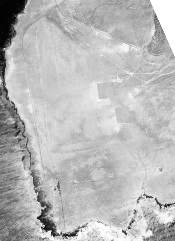
Morse Field had a runway and one small barracks.  Then, they expanded the facility and it was referred to as Kalae Military Reservation.   In 1940, construction was underway on five buildings, runways and access roads at Morse Field.  Activities were centralized at this airport inasmuch as its location shortened a routing through Oahu, the trans-Pacific air ferry route to Australia and the Philippines by approximately 200-miles.

The work on runways at Morse Field was suspended shortly after the attack on Pearl Harbor (December 7, 1941 – there were at least 2 fighters stationed at the strip when Pearl Harbor was attacked) and all adjacent smooth ground potential landing areas demolished as a precautionary measure against enemy use.

Blocking of landing areas on the island occupied large amounts of time and manpower due to the extensive areas involved and the comparatively smooth surfaces surrounding the field, which could be used as landing fields.

Later, construction increased the number of buildings to 5, built nine 50,000 gallon fuel tanks, a water line, access roads, and extended the runway to 6,000-feet.  Morse Field was an earth field with a Marston Mat (steel grid) runway and was constructed as a temporary facility.

Gun emplacements were also added around the field.  By December 28, 1941 gasoline storage facilities were complete, a water line installed and mobilization buildings were more than half finished.

After World War II, Morse Field was declared surplus by the military in 1946 and the Territorial Legislature placed it under the management of the Hawaii Aeronautics Commission (HAC.)

Rancher James Glover made a survey of the airport and found the buildings to be of no value except the corrugated roofing.  He said he was in favor of keeping the airport open so that slaughtered cattle could be shipped out.  He offered to maintain the airport at his own expense and to keep it open at all times as an emergency landing strip.

On November 3, 1947, the Commission made an application for the South Cape Airport to enter into an agreement with Mr. Glover.  The U.S. Army granted a right of entry into Morse Field to the Territory on January 16, 1948.

Because of its remote location the HAC expected very little use by commercial airlines. Since satisfactory sites in this part of the island where aircraft could set down with safety in case of an emergency were non-existent, the Hawaii Aeronautics Commission decided to retain this strip as an emergency landing field.

With minimal maintenance (Hilo Airport staff made quarterly trips to Morse Field to perform minor maintenance and repair work,) by 1952 the field was found to be in bad condition due to erosion around the edges of the mats.

In the meantime, a new Federal Aid Highway project had been completed into Hilo, which caused the entire community to look to the Hilo Airport for their transportation needs. As a result, traffic into the field came to a standstill.

In 1954, the Territorial Director of Aeronautics requested abandonment of the airport; it was abandoned the next year.

In December 1964, the Air Force Systems Command announced that the Air Force would assume control of space tracking and communications from the Navy; the station closed the next year.

It was later reopened to support a sounding rocket probe program to evaluate advanced ballistic reentry system experiments.  The close proximity and aspect angle of South Point to the optical site sensors located on the island of Maui were the primary reasons for launching the probes from this location.

In 1979, the Station was divided in two parcels located about 1.5-miles apart. One of the sites was the main operations area, while the other area was used for a radar tower.  The Station was under the operational control of the Space and Missile Test Center (SAMTEC).

The short-lived South Point Air Force Station was one of the few Air Force installations in the State of Hawaiʻi that did not fall under the control of the 15th Air Base Wing. It belonged to the Air Force Systems Command (AFSC,) headquartered at Andrews AFB.

That use ended, too; in 1983 the executive orders for the facility were cancelled.   Also in the 1980s, there were discussions about a private rocket launching facility here, but those never came to fruition.  (Lots of info here from hawaii-gov and Freeman.)

The image shows Morse Field at Ka Lae, South Point in 1945.

Follow Peter T Young on Facebook  

Follow Peter T Young on Google+  

Follow Peter T Young on LinkedIn   

© 2014 Hoʻokuleana LLC

Filed Under: Military Tagged With: Hawaii, Hawaii Island, Morse Field, South Point, Suiter Field

Images of Old Hawaiʻi

People, places, and events in Hawaiʻi’s past come alive through text and media in “Images of Old Hawaiʻi.” These posts are informal historic summaries presented for personal, non-commercial, and educational purposes.

Info@Hookuleana.com

Connect with Us

  • Email
  • Facebook
  • LinkedIn
  • Twitter
  • YouTube

Recent Posts

  • For the Birds
  • James Otis
  • Raising the United States Flag
  • Kamehameha III’s Secret Agreement of US Annexation
  • Daguerreotype
  • Wahiawā
  • Math’s Life Lessons

Categories

  • General
  • Ali'i / Chiefs / Governance
  • Buildings
  • Missionaries / Churches / Religious Buildings
  • Hawaiian Traditions
  • Military
  • Place Names
  • Prominent People
  • Schools
  • Sailing, Shipping & Shipwrecks
  • Economy
  • Voyage of the Thaddeus
  • Mayflower Summaries
  • American Revolution

Tags

August Hering Charles Sheldon Judd Chief D-Day Dentistry DOE Dredging Ephraim Weston Clark Floating Island Hawaiian Islands Humpback Whale National Marine Sanctuary Hawaii Invasive Species Council HECO Henry AP Carter Henry Martyn Whitney John Webber Joseph Boyd Poindexter Kalaniopuu Kanaina Ka Wai O Pele Keei Kini Popo Lava Tube Liliuokalani Educational Society Makai Arterial Makanau Makaweli Molokai Oklahoma Paia High School PASH Patricia Jennings Pohaku O Lanai Ponoholo Ranch Puuhonua Richard Boone Robert Boyd St Catherine's St John Vianney Termite Palace Territorial Hospital Waikiki Roughwater Swim Waikolu Yale Yokohama Specie Bank Zephaniah Swift Spalding

Hoʻokuleana LLC

Hoʻokuleana LLC is a Planning and Consulting firm assisting property owners with Land Use Planning efforts, including Environmental Review, Entitlement Process, Permitting, Community Outreach, etc. We are uniquely positioned to assist you in a variety of needs.

Info@Hookuleana.com

Copyright © 2012-2021 Peter T Young, Hoʻokuleana LLC


Loading Comments...