Images of Old Hawaiʻi

  • Home
  • About
  • Categories
    • Ali’i / Chiefs / Governance
    • American Protestant Mission
    • Buildings
    • Collections
    • Economy
    • Missionaries / Churches / Religious Buildings
    • General
    • Hawaiian Traditions
    • Other Summaries
    • Mayflower Summaries
    • Mayflower Full Summaries
    • Military
    • Place Names
    • Prominent People
    • Schools
    • Sailing, Shipping & Shipwrecks
    • Voyage of the Thaddeus
  • Collections
  • Contact
  • Follow

November 25, 2025 by Peter T Young 3 Comments

Kazumura Cave

The ʻAilaʻau eruption is considered the longest memorable eruption of Kilauea.

(Before Pele, there was ʻAilaʻau (Ai means the ‘one who eats or devours.’ Laʻau means ‘tree’ or a ‘forest.’) ʻAilaʻau was, therefore, the fire-god devouring forests. When Pele came, she took over as fire goddess, ʻAilaʻau left.) (Westervelt)

The ʻAilaʻau eruption took place from a vent area just east of Kilauea Iki. The eruption built a broad shield. The eastern part of Kilauea Iki Crater slices through part of the shield, and red cinder and lava flows near the center of the shield can be seen on the northeastern wall of the crater.

The eruption probably lasted about 50-years, from about 1420 to 1470 AD. The large volume of lava covered a huge area, about 166 square miles (106,240-acres) – larger than the Island of Lanaʻi (140-square miles.)

Lava covered all, or most, of what are now Mauna Loa Estates, Royal Hawaiian Estates, Hawaiian Orchid Island Estates, Fern Forest Vacation Estates, Eden Rock Estates, Crescent Acres, Hawaiian Acres, Orchid Land Estates, ʻAinaloa, Hawaiian Paradise Park and Hawaiian Beaches.

The pahoehoe flows did leave rather large kipuka south of Keaʻau and in the forest southwest of ʻAinaloa, as well as small kipuka in Hawaiian Paradise Park and elsewhere.

This eruption and lava flow may be described in the Pele-Hiʻiaka chant. Hiʻiaka, late on returning to Kilauea from Kauai with Lohiau, sees that Pele has broken her promise and set afire Hiʻiaka’s treasured ʻohiʻa lehua forest in Puna.

Hiʻiaka is furious, and this leads to her love-making with Lohiau, his subsequent death at the hands of Pele, and Hiʻiaka’s frantic digging to recover the body.

The ʻAilaʻau flows seem to be the most likely candidate to have covered so much of Puna that they were worthy of commemoration in the chant.

The timing seems right, too – after the Pele clan arrived from Kahiki, before the caldera formed (Hiʻiaka’s frantic digging may record this), and before the encounters with Kamapuaʻa, some of which probably deal with explosive eruptions between about 1500 and 1790. (USGS)

Reminders of past eruptions are lava tubes. Lava tubes are natural conduits through which lava travels beneath the surface of a lava flow. Tubes form by the crusting over of lava channels and pāhoehoe flows.

When the supply of lava stops at the end of an eruption or lava is diverted elsewhere, lava in the tube system drains downslope and leaves partially empty conduits beneath the ground. (USGS)

One such, as a result of the ʻAilaʻau eruption, is Kazumura Cave – it has been called the longest (over 40-miles) and (to some) deepest lava tube in the world and the deepest cave in the US. (Cultural Surveys)

According the Hawaiian Government Surveyors in 1891 (related to ‘The New Puna Road:’) “An interesting feature of this locality is the large number of lava caverns and long subterranean passages abounding upon it, especially between the 9th and 11th miles, in fact this whole tract is so thoroughly penetrated by caverns that hollow sounds are often heard beneath ones footsteps when traversing the region.”

“These subterranean passages are generally entered through some opening made by the falling in of the roof and prove to be regular arched ways, ranging as much as 25 feet in width and 15 feet high and extending for long distances.”

“The floors have that corrugated ropy appearance such as are seen on any viscid mass if drawn out as it hardens. The roofs and sides are covered with stalactites, the whole producing a wonderful effect when lit up.”

“These caverns evidently served as burial places in ancient and comparatively modern times in view of the fact that the benches here and there were covered in human remains.” (Cultural Surveys)

“Its average inclination was found to be 1.75 degrees, less in its lower section and considerably more in the upper sections. Passage cross-sections also were found to be different in the different areas.”

“While considerable local variation exists, its lower end tends to be wide and comparatively low while the upper section tends to be high and narrow. Locally, slip slopes and cut banks were found at sharp bends. Lavafalls up to about 15 m are numerous, especially in the upper sections.” (Halliday)

I have asked everyone who I thought should know who Kazumura was (the apparent namesake of the cave/lava tube.) Any insight into who Kazumura was is appreciated.

© 2025 Hoʻokuleana LLC

Filed Under: General, Place Names Tagged With: Hawaii, Hawaii Island, Puna, Kazumura Cave, Lava Tube

July 18, 2024 by Peter T Young Leave a Comment

Waiwelawela

Paʻu o keahi o Waiwelawela o ka lua e
Aloha na poʻe la o

The pit of Waiwelawela is encircled by fire
Greetings to the people of the upland pit

(From the chant “A popoʻi haki kaikoʻo” – it describes how Pele got established in Puna; it compares the movement of the lava to the movement of water.)

There are indications that the ancient Hawaiians made use of natural hot springs for recreation and therapy. Oral history relates that the ancient chieftain, Kumukahi, frequented hot springs in Puna to relieve his aches and pains.  (Woodruff/Takahashi)

“The fame of the waters of the warm springs of the Puna districts has been great during many years. In fact, it is a legend … that when the ailments of the body overcame the aliʻi of old they betook themselves to the spring known as Waiwelawela … and there they were healed of rheumatic affections through bathing, and their systemic ills cured by drinking of the waters.”

“This legend has come down to the Hawaiians of today and even now there is a fame attached to the waters of the springs, which draws to the side of the stream scores of the native residents of nearby districts.” (Pacific Commercial Advertiser, January 28, 1902)

Waiwelawela “is a warm spring, crescent shaped, and of a vivid ultramarine in color …. The spring, named the Blue Lake, is 90-deg in temperature and 900-feet above the level of the sea.  The water is wonderfully clear and, strange to relate, at this elevation, it has a regular rise and fall which is said to correspond to the tide of the ocean.”  (Daily Bulletin, August 28, 1882)

The Kapoho Warm Springs was formed when the downthrown block of the Kapoho fault slipped below the water table and exposed the warm waters, probably heated by a magmatic body intruded in 1840.  (USGS)

“At present no practical use is made of them, but were there a proper access a small hotel would be built and many invalids would be able to make use of these springs.”  (Hawaiian Gazette, September 17, 1889)

“The famous warm spring is to be found near the residence of Mr RA Lyman (Kapoho’s largest landowner) and is one of the finest bathing places on the islands.  Natives formerly flocked to the place from all over the islands believing that it was possessed of great healing powers.”

“The water is a pleasant temperature for bathing and is clear as crystal, small objects can be readily distinguished twenty feet below the surface. There is a mineral taste to the water.”  (Pacific Commercial Advertiser, March 22, 1892)

“The railway now goes so close to them that it is believed if a few cottages were built, and attendance provided, many afflicted people would be glad to go there and be healed.  Even those who need no physician would find at these springs a place for rest and contemplation, far from the maddening crowd.”  (Pacific Commercial Advertiser, October 12, 1908)

“It is the most marvelously beautiful place in all these beautiful islands. There is not a doubt of it. The pool, at the base of a small peak that is like what Diamond Head would be if that had sugar cane growing to its very summit, lies shaded by a dense growth of ʻōhiʻa and koa and lehua trees and guava bushes, the sun glistening upon it through the leaves of these.”

“The waters, not steaming, but of perceptibly higher temperature than the air, by some strange law of refraction are shot through with dazzling gleams of a blue that is like the blue depths of the sky. Yet the rocks in the pool are not blue. They are of rather reddish cast.”  (Mid-Pacific Magazine, 1912)

“The exposed basin where the spring comes to the surface is something like five by six yards, and the water rises from no one knows where and departs no one sees how.  The water is warm and is very full of mineral salts.”  (Pacific Commercial Advertiser, January 28, 1902)

“This spot is unquestionably one of the loveliest in all Hawaiʻi, and its charm is typical of Hawaiʻi.  It is close against the face of a volcanic cliff.  Here there is a shady grotto, and in this grotto a pool almost as it hewed out of the rocks for the bathing place of some giant of the forest.”

“The water is in spots 20-feet deep, but so translucent that it seems much less than 10.  It holds many lights and shadows, many hues and colors, varying from the deep indigo blue to a transparent jade-green and in spots a golden brown.  There are seats here and the shade is grateful.”  (Honolulu Star-bulletin, September 6, 1916)

At Warm Springs, where portions of ‘Bird of Paradise’ (1951) and other motion pictures had been filmed, stone steps led to a spring-fed, naturally heated pool fringed by ferns, cattleya orchids and lau hala trees.

The grounds and a half-mile drive were landscaped with plumeria, thousands of ti plants, crotons and ginger. Picnic tables and barbecue pits dotted a smooth lawn shaded by mango trees.  Slim Holt, who leased the property from Lyman, had labored for years to create this beauty, assisted by interested individuals and organizations.  (Flanders)

Then, “Something was amiss.”  An eruption at Kilauea had ended on December 21, 1959.

“(B)ut the shallow reservoir beneath the summit of Kilauea volcano was gorged with magma, far more than before the eruption started. Rather than removing pressure, the eruption had, for all intents and purposes, created more.”

“The uncertainty ended at 1935 January 13, (1960,) when red glow in the night sky above Kapoho announced the 1960 eruption.”  (USGS)

Bulldozers erected a quarter-mile line of dikes designed to prevent the lava from reaching Warm Springs.  Despite this effort, toward midnight the flow surmounted the embankments.

Barbecue pits exploded; trees, shrubbery, tables and benches burst into flame. Lava poured down stone steps in a cherry-red stream.  Still water, reflecting the infernal scene, disappeared under the flow. The new cinder cone was dubbed Puʻu Laimanu.  … Today, buried beneath this primeval landscape, under 50-feet of lava, lays Warm Springs.  (Flanders)

“Estimates of damage from the six-day eruption of Kilauea volcano rose into the millions today.  State Senator Richard F Lyman estimated damage to his land, blanketed by the lava as $2,000,000.”

“He owns 80-acres of sugar land and the Warm Springs resort area, now buried by the flow on Hawaiʻi Island.  Other landowners reported 3,500-acres of farmland destroyed.”  (The Spokesman, January 20, 1960)

“Waiwelawela (meaning ‘warm water’) was a warm spring pool near Kapoho which was covered in the 1960 eruption. … It is said by people of the area that Pele covered the springs because people were charging others, namely Hawaiians, for use of the warm springs. In former days these warm springs were available to everyone.”  (Pukui; DOE)

© 2024 Hoʻokuleana LLC

Filed Under: Place Names Tagged With: Pele, Puna, Kapoho, Hawaii, Eruption, Hawaii Island, Warm Springs, Waiwelawela

January 21, 2023 by Peter T Young Leave a Comment

Growing Pains

Oʻahu is about 382,500-acres in size; the district of Puna on the island of Hawaiʻi is about 320,000-acres in size – almost same-same.

According to the 2020 census, Oʻahu has about 984,000-people and Puna has about 46,800.  That means there are less than a half-acre per person on Oʻahu and about 7-acres per person in Puna.

For some, it sounds like optimal living; and, many are moving to the Big Island to enjoy this rural lifestyle.

Open spaces with room to roam, it sounds kind of like the Wild West.  And, for some, that’s its nickname, however, not with the same context.

Wait, there’s more.

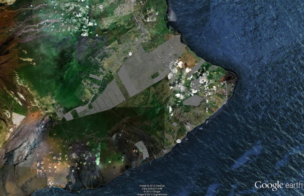
Between 1958 and 1973, more than 52,500-individual lots were created.  There are at least over 40 Puna subdivisions. Geographically, these subdivisions are sometimes as big as cities.

For example, Hawaiian Paradise Park has over 8,800 building lots and is reportedly the second largest private subdivision in the United States.  It is over 4-miles long and nearly 3½-miles wide.

Back then, they plotted out the subdivisions in cookie-cutter residential/agricultural lots across a grid, with very little space for other uses (such as parks, open space, government services, regional roads … the list goes on and on.)

To add insult to injury, most subdivision lots are accessed by private, unpaved roads. The streets generally lack sidewalks and lighting, and do not meet current County standards in terms of pavement width, vertical geometrics, drainage and other design parameters.

There are only two main roads to move the people in the district in and out – one (Route 130 – Keaau-Pahoa Road) goes into Pahoa to Kalapana; the other (Route 11 – Volcano Highway) serves the lots up in the Volcano area.

Most lots rely on individual catchment systems (captured off the roof and rainfall stored in water tanks) supplemented with private delivery trucks for drinking water.  None of the subdivisions have central sewer systems. Large sections of some subdivisions are off the power grid.

Oh, and one more thing, about 6,400 subdivision lots lie in the highest lava hazard zone and over 500 of these are exposed to additional risks from subsidence, tsunami and earthquakes.

That’s not just hazards noted on a map; thousands of these lots have been covered by lava flows or have been rendered unbuildable by shoreline subsidence over the years.

While most of these subdivisions are on agricultural-zoned lands, the actual use of developed lots is predominantly residential.

At the time these subdivisions were approved, the Puna district was sparsely populated and, with the exception of a sugar plantation and a small-scale visitor attraction at the volcano, which had not yet been developed as a national park, there was little economic activity in the area.

Shortly after the approval of the first of these subdivisions, Hawai‘i was admitted as the 50th state. That event, coinciding with jet travel, spurred increased investment in the Islands.

To prevent the excesses of land speculation, Hawai‘i adopted the first State Land Use Law in the nation in 1961.

Most of the Puna district was placed in either the Conservation District or the Agriculture District when formal boundaries were established in 1964, and this somewhat served to abate the number of subdivision applications.

However, it wasn’t until the County adopted a subdivision ordinance in 1973, setting more rigorous lot size and infrastructure standards, that large subdivisions with minimal services were effectively discouraged.

In the first decade or so following the creation of the non-conforming subdivisions, lot sales were fairly brisk, but there was little lot development.

In the 1970 Census, the recorded population of the Puna District was only 5,154-residents, most of whom lived in the older settlements of Kea‘au, Pāhoa and Volcano.

That was then, over the years the population exploded, doubling to 11,751 in 1980, then up another 10,000 by 1990 (to 20,781,) and another 11,000 by 2000 (to 31,335,) and another 14,000 by 2010 (to 45,326) to the 2020 population of about 46,800.

Population growth has worn on the minimal infrastructure, as well as people’s patience.

Today, folks in Puna are living with the lack of planning and regulatory control over the subdivision bonanza days.  But, they do benefit from lower sales prices (associated with the general lack of facilities and the huge availability.)  Some say you are getting what you pay for.

This region is finally undergoing some short and long-range planning.  And, there are attentive council members seeking to have Puna get its fair share.

Depending on your perspective, addressing the issues in this region today is either a planner’s nightmare or a planner’s dream.  This is an area where I would love to get involved – for me, challenges create opportunities.

The image notes the individual parcels within the Puna district (overlaying the Google Earth image.)  At this scale, many of the lots are not discernible – the fully gray areas indicate smaller lot residential uses, with no (or very limited) park space – where you can just see between the lines, these are 1-5 acre parcels.

© 2023 Hoʻokuleana LLC

Filed Under: Place Names, Economy Tagged With: Hawaii, Puna, Subsidence, Hawaii County, Lava Hazard

January 13, 2023 by Peter T Young Leave a Comment

1960 Kapoho Eruption

The eruption in Kilauea Iki had ended on December 21, but the shallow reservoir beneath the summit of Kilauea volcano was gorged with magma. Rather than removing pressure, the eruption had, for all intents and purposes, created more.

The end of 1959 was an uneasy time for the staff at the Hawaiian Volcano Observatory.  During the last week of the year, a swarm of earthquakes started in Pāhoa (more than 1,000 earthquakes were recorded by the Pāhoa station on January 12.)

The 1960 Kapoho eruption and its predecessor, the 1959 summit eruption in Kilauea Iki Crater, together formed a summit-flank sequence. The Kapoho eruption caused havoc in lower Puna, an idyllic rural community until the lava fountains and flows covered farm land and villages.

The size and frequency of the earthquakes increased; at 8 am, January 13, the ground was severely cracked along the fault through Kapoho town.  Movement along the fault was literally pulling the town apart.

The ground was constantly shaking. The roughly 300-residents undertook voluntary evacuation, which was completed by early evening.  At 7:35 pm, January 13, 1960, a red glow above Kapoho confirmed the start of the eruption.

Within half an hour, fountaining was nearly continuous along a nearly ½ – mile long fissure.  After a couple hours, the activity focused with central fountains – for the next 11-hours powerful steam blasts roared from the vents.

The resulting fallout coated everything with a thin film of fine, wet, glassy ash. Salt crystals formed as the water evaporated; they testified to the brackish nature of the groundwater.

By noon on January 14, the steam blasts had ended and lava fountaining was confined to many sources along a 650-foot long section of the fissure.  An ʻaʻa flow, 18-feet thick and nearly 1,000-feet wide reached the ocean – a bench formed 300-feet beyond the old shoreline.

In an attempt to save Warm Springs, bulldozers pushed a rock dike; shortly after, lava overtopped it and filled the pool.

Kapoho, a bit uphill of the fissure, was near all this activity but had not been touched by lava. Pumice and lava were wreaking havoc on nearby homes and farms (papaya, coconut, orchid and coffee groves.)

ʻAʻa continued to enter the ocean; it was also spreading southward.  Bulldozers worked in forming a barrier to protect Kapoho, Kapoho School, an area of expensive homes and real estate at Kapoho Beach Lots.  By January 20, lava had reached the barrier and overtopped it on January 23; a second barrier was shoved aside on January 27.

A third barrier held the flow, but lava then moved underground, beneath the end of the barrier, emerging near Kapoho School. The buildings began to burn at 10 am and the school was lost shortly after noon.

The barrier itself remained intact, and it survived until February 5, when it was finally overtopped and almost totally buried by lava that eventually covered the Kapoho cemetery.  More coastal houses were lost.

Despite notable developments in the vent area, Kapoho village remained virtually intact except for a blanket of pumice and ash that covered everything.

For seven hours on the afternoon of January 27, the heaviest pumice fall of the entire eruption rained down on the area during strong kona winds.

However, it was the lava flow that would doom the town.

Late that night, the rapidly moving ʻaʻa flow moved through the streets, overwhelmed building after building. By midnight January 27, most of Kapoho had been destroyed; a couple days later (January 30) the town was gone.

The eruption ended slowly. Dribbles of lava continued to enter the sea north of Cape Kumukahi as late as February 13. High fountains continued until February 15, when lava was spraying upward from the main vent area to heights of 600-feet.  It gradually subsided and on the morning of February 19, the eruption stopped.

Volcanologists concluded that the Kapoho eruption was tied to events at Kilauea’s distant summit.  On January 17, four days after the Kapoho eruption had started, the summit began to subside (deflate, by analogy with a balloon) as magma was leaving the storage reservoir and heading down the east rift zone to the Kapoho area.

The eruption was the first during the modern era of volcano monitoring at Hawaiʻi Volcanoes Observatory. As a result, probably more fundamental ideas were reached from it than from any other single eruption in Hawaiʻi.

The main lesson, and really the only one that bears repeating over and over again, is clear. What happened then will happen again. That lesson should never be lost.  (All information here is from USGS.)

© 2022 Hoʻokuleana LLC

Filed Under: General, Place Names Tagged With: Cape Kumukahi, Pahoa, Kilauea Iki, Kilauea, Hawaii, Volcano, Warm Springs, Waiwelawela, Puna, Kapoho

October 20, 2022 by Peter T Young Leave a Comment

Pāhoa

Early settlement patterns in the Islands put people on the windward sides of the islands, typically along the shoreline.  However, in Puna on the Island of Hawaiʻi, much of the district’s coastal areas have thin soils and there are no good deep water harbors. The ocean along the Puna coast is often rough and windblown.

As a result, settlement patterns in Puna tend to be dispersed and without major population centers. Villages in Puna tended to be spread out over larger areas and often are inland, and away from the coast, where the soil is better for agriculture.  (Escott)

This was confirmed on William Ellis’ travel around the island in the early 1800s, “Hitherto we had travelled close to the sea-shore, in order to visit the most populous villages in the districts through which we had passed. But here receiving information that we should find more inhabitants a few miles inland, than nearer the sea, we thought it best to direct our course towards the mountains.”  (Ellis, 1823)

An historic trail once ran from the modern day Lili‘uokalani Gardens area in Hilo to Hāʻena along the Puna coast. The trail is often referred to as the old Puna Trail and/or Puna Road. There is an historic trail/cart road that is also called the Puna Trail (Ala Hele Puna) and/or the Old Government Road.

This path was essentially the main thoroughfare through the Puna district before the late-1800s.  Pāhoa was oʻioʻina (a resting place) on the trail.  (Papakilo)  Then it grew to become the principal town of lower Puna.

The evolving trail (first by foot, then by horse, cart and buggy, and finally by automobile) likely incorporated segments of the traditional Hawaiian trail system often referred to as the ala loa or ala hele.  (Rechtman)

The full length of the Puna Trail, or Old Government Road, might have been constructed or improved just before 1840. The alignment was mapped by the Wilkes Expedition of 1804-41.  (Escott)

People who traditionally had lived along the Puna coast were moving toward Hilo and into the more fertile upland areas of Puna in order to find paid work and to produce cash crops for local markets and for export.

The focus began to shift to the center of the Puna District and the developing sugar and related industries near ʻŌlaʻa, Hilo and the volcano region.

Before the turn of the century, railroad operations began – with lines running into Hilo. A main railroad line and several feeder lines were constructed in the early-1900s from Keaʻau to locations in lower Puna District.

The major line ran from Hilo through Keaʻau to the Kapoho area.  A branch line ran from the ʻŌlaʻa Sugar Mill up past present day Glenwood. A second branch line ran to Pāhoa town.

Some suggest this is how Pāhoa received its name.  “Then the train was put in from Hilo to Puna. One spur went up into Pāhoa; it was like a dagger into the forest. I‘m told this is how Pāhoa got its name. (Pāhoa means dagger.)”  (Edwards; Cultural Surveys)

People began to work in the inland areas to grow sugarcane. The new road, the Pāhoa branch of the railroad, sugarcane agriculture and a logging venture all combined to create Pāhoa as a population center in the region.  (Rechtman)

Macadamia nuts and papaya were introduced in 1881 and 1919; at the turn of the century, large-scale coffee cultivation was attempted.  Over 6,000-acres of coffee trees were owned by approximately 200-independent coffee planters.

This fledgling industry couldn‘t compete with more successful ventures located in other districts, and after a few decades the coffee industry in Puna was abandoned.  (Cultural Surveys, Rechtman)

By 1901, sugar dominated the island’s industry and landscape, and Hilo was the epicenter of production and export. Railroads connected sugar mills and sugar plantations in Hilo, the Hāmākua and Puna. The railroad also connected the mills to the wharves at Hilo Bay.

Early on, one of the major export items transported by the railroad was timber.  Starting in 1907, the Hawaiian Mahogany Company began cutting trees to clear land for sugarcane. The logs were brought to Pāhoa Town to be milled, then sent to Hilo Harbor and eventually shipped to the US Mainland as railroad ties for the Santa Fe Railroad.

The lumber mill facilities and the railroad line that served them were located near the center of town where the Akebono Theater is located.

In 1909, the company was renamed Pāhoa Lumber Company. In 1913, the main mill facilities were lost in a fire; it was rebuilt that year the company was renamed the Hawaiian Hardwood Company.

The company closed down in 1916 when the Santa Fe Railroad ended its contract to buy lumber. The defunct company then leased its mill facilities, buildings and railroad tracks to the expanding ʻŌlaʻa Sugar Company.  (Rechtman)

Today, Pāhoa Town has a main street – the former highway route before the construction of the by-pass road – that still retains much of the original street-wall of plantation-era structures, as well as some significant stand-alone buildings.

Most of the uses are commercial or civic.  The County has acquired a large tract of land within Pāhoa Town, which presents a significant opportunity for community revitalization and a possible catalyst for economic activity.  (Puna CDP)

© 2022 Hoʻokuleana LLC

Filed Under: Economy, General, Place Names Tagged With: Sugar, Coffee, Macadamia Nuts, Hawaii, Hawaii Island, Puna, Pahoa

  • 1
  • 2
  • 3
  • Next Page »

Images of Old Hawaiʻi

People, places, and events in Hawaiʻi’s past come alive through text and media in “Images of Old Hawaiʻi.” These posts are informal historic summaries presented for personal, non-commercial, and educational purposes.

Info@Hookuleana.com

Connect with Us

  • Email
  • Facebook
  • LinkedIn
  • Twitter
  • YouTube

Recent Posts

  • Martin Luther King at the Hawai‘i Legislature
  • Gilberts and Marshalls
  • It Wasn’t ‘Bloodless’
  • Universal Remedy
  • Aiʻenui
  • Victoria Kamāmalu
  • Ginaca

Categories

  • Military
  • Place Names
  • Prominent People
  • Schools
  • Sailing, Shipping & Shipwrecks
  • Economy
  • Voyage of the Thaddeus
  • Mayflower Summaries
  • American Revolution
  • General
  • Ali'i / Chiefs / Governance
  • Buildings
  • Missionaries / Churches / Religious Buildings
  • Hawaiian Traditions

Tags

Albatross Al Capone Ane Keohokalole Archibald Campbell Bernice Pauahi Bishop Charles Reed Bishop Downtown Honolulu Eruption Founder's Day George Patton Great Wall of Kuakini Green Sea Turtle Hawaii Hawaii Island Hermes Hilo Holoikauaua Honolulu Isaac Davis James Robinson Kamae Kamaeokalani Kameeiamoku Kamehameha Schools Lalani Village Lava Flow Lelia Byrd Liberty Ship Liliuokalani Mao Math Mauna Loa Midway Monk Seal Northwestern Hawaiian Islands Oahu Papahanaumokuakea Marine National Monument Pearl Pualani Mossman Quartette Thomas Jaggar Volcano Waikiki Wake Wisdom

Hoʻokuleana LLC

Hoʻokuleana LLC is a Planning and Consulting firm assisting property owners with Land Use Planning efforts, including Environmental Review, Entitlement Process, Permitting, Community Outreach, etc. We are uniquely positioned to assist you in a variety of needs.

Info@Hookuleana.com

Copyright © 2012-2024 Peter T Young, Hoʻokuleana LLC


Loading Comments...