Images of Old Hawaiʻi

  • Home
  • About
  • Categories
    • Ali’i / Chiefs / Governance
    • American Protestant Mission
    • Buildings
    • Collections
    • Economy
    • Missionaries / Churches / Religious Buildings
    • General
    • Hawaiian Traditions
    • Other Summaries
    • Mayflower Summaries
    • Mayflower Full Summaries
    • Military
    • Place Names
    • Prominent People
    • Schools
    • Sailing, Shipping & Shipwrecks
    • Voyage of the Thaddeus
  • Collections
  • Contact
  • Follow

August 11, 2024 by Peter T Young Leave a Comment

Barrage Terraces

In pre-contact (prior to Captain Cook) times, kalo (taro) played a vital role in Hawaiian culture. It was not only the Hawaiians’ staple food, but the cultivation of kalo was at the very core of Hawaiian culture and identity.

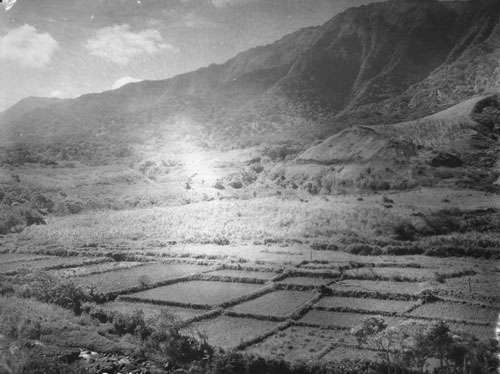
The early Hawaiians probably planted kalo in marshes near the mouths of rivers. Over years of progressive expansion of kalo lo‘i (flooded taro patches, pondfields) up slopes and along rivers, kalo cultivation in Hawai‘i reached a unique level of engineering and sustainable sophistication.

Hawaiians knew the productive advantages of growing wetland taro and placed the greater effort in this area very early, when required to increase food production capabilities for the rapidly increasing number of people.

By the time of Captain Cook’s visits in 1778 and 1779, every large river valley in the islands contained many loʻi (pondfields,) and each was systematically irrigated by means of ditches delivering water to the fields spread throughout the valley.

Usually, water was fed into an irrigation ditch from a stream. A loose-rock dam built across the stream allowed water to flow between and over the top of the rocks to provide for farmers living downstream. The dam functioned to raise the water level just high enough at that point to permit water to flow into the ditch leading to the terraces.

In this way the amount and speed of the water could be controlled. If too much water was found to be flowing into the ditch, a few stones could be removed from the dam, thus lowering the water level and reducing the volume of water entering the ditch.

The speed of the flow of water into the pondfields was controlled by the length and slope of the ditch. By varying the length and grade of the ditch, its builders were able to maintain a constant and low-level gradient over variegated terrain. The flow through the pond fields was controlled by the height of the terraces.

Captain George Vancouver visited Hawai‘i in 1792 and wrote, “Our guides led us to the northward through the village [Waikiki], to an exceedingly well-made causeway, about twelve feet broad, with a ditch on each side.”

“This opened to our view a spacious plain…the major part appeared divided into fields of irregular shape and figure, which were separated from each other by low stone walls, and were in a very high state of cultivation.” (Vancouver)

In 1815, the explorer Kotzebue added to these descriptions by writing about the gardens and the artificial ponds that were scattered throughout the area:

“The luxuriant taro-fields, which might be properly called taro-lake, attracted my attention.  Each of these consisted of about one hundred and sixty square feet, forms a regular square, and walled round with stones, like our basins.”

“This field or tank contained two feet of water, in whose slimy bottom the taro was planted, as it only grows in moist places. Each had two sluices. One to receive, and the other to let out, the water into the next field, whence it was carried farther.” (Kotzebue)

Of the lo‘i types, “More common are stone-faced pondfields constructed either on [alluvial] slopes or alluvial terraces (SB), but not directly in stream channels; this is the dominant pondfield type ….”

“[T]he stone facing is generally a veneer of one-stone or two-stone thickness. Such facings apparently add stability to pondfields on steeper slopes; they may also be a means of removing unwanted loose stone from the soil media.”

[But, they are not the only type of lo‘i.] “These pondfields have been artificially filled, in contrast to the barrage fields which catch stream sediment.” (Kirch)

Stone-walled barrage pondfields “are what Spencer and Hale (1961:8) term ‘narrow channel barrage terraces.’ They were constructed by building a barrage of stones across a narrow stream channel (usually intermittent or with little flow) …”

“… and allowing soil and rock to accumulate behind the stone facing, thus creating a level planting surface which spread and impounded the channel’s waterflow.”  (Kirch)

The barrage was sometimes “in sequential system of terraces … [providing] high level of context for function as an agricultural terrace and/or for water or soil retention or movement”. (Kamakakūokalani)

David Malo explained how a taro garden could keep a large number of people in vegetable food continuously: “Some farmers did not plant a great deal at a time. They would plant a little, and after waiting a few months, they planted more land.”

“So they continued to plant a little at a time during the months suitable for planting. The food did not all ripen at once, and by this plan the supply was kept up for a long time and they had no lack of food.”  (Malo)

An acre of irrigated pondfields produced as much as five times the amount of taro as an acre of dryland cultivation. Over a period of several years, irrigated pondfields could be as much as 10 or 15 times more productive than unirrigated taro gardens, as dryland gardens need to lie fallow for greater lengths of time than irrigated gardens.

Rev. Armstrong suggested that there would be ‘food enough for ten persons’ on an acre of average taro land in Honolulu, that is, subsistence for ten persons.

“With proper management, kalo (taro) land needs no rest. So the natives tell me. Let the water be kept constantly upon it and the weeds cleared out and that is all that is needed. The kalo plants, however, must be changed every crop. It requires about a year to bring a crop of kalo to maturity.”  (Armstrong)

Rev. Johnson of Hanalei, Kauai, a noted wetland taro-producing valley, suggested that 25 people subsist on an acre of good taro land.

Writing from his experiences on the well-watered windward side of Oʻahu, Rev. Parker wrote: “An acre of kalo land would furnish food for from twenty to thirty persons, if properly taken care of. It will produce crops for a great many years in succession, without lying fallow any time.”

Rev. Bishop, writing from ʻEwa District on Oʻahu, suggested that 15-20 people could be fed from an acre of taro: “Good kalo land, irrigated by water, improves by cultivation. It only requires time enough between crops to rot the weeds, which serve as manure.”

Rev. Emerson lived and worked in Waialua District on Oʻahu where several large rivers and numerous springs watered the land.  He wrote: “Twenty persons, I think can be fed on an acre of good kalo land.”

“The land can generally be cultivated perpetually, if it has two or three months between each crop, in which to decompose the weeds which might grow during the time the kalo was ripening.”

“I have a large kalo patch that has not been left to rest one month at a time for fifteen years, and yet it produces as largely as fifteen years since. I presume the same parch was cultivated centuries before I knew it. It requires one year for kalo to come to maturity.” (Bishop)

© 2024 Ho‘okuleana LLC

Filed Under: Hawaiian Traditions Tagged With: Hawaii, Loi, Kalo, Taro, Pondfield, Barrage Terrace

February 18, 2023 by Peter T Young Leave a Comment

Kuāuna

According the research and reporting by noted archaeologists, there were three main technological advances resulting in food production intensification in pre-contact Hawai‘i: (a) walled fishponds, (b) terraced pondfields with their irrigation systems and (c) systematic dry-land field cultivation organized by vegetation zones.

The lo‘i kalo (terraced pondfields), a technological invention by Hawaiian Polynesians, was the development of their extended stone-faced, terraced pondfields (lo‘i) and their accompanying irrigation systems (‘auwai) for the intensive cultivation of wetland taro (kalo.)

“The ground within the lo‘i [was] broken by means of a mattock or ‘ō‘ō. ‘Ō‘ō designates the tool largely used by the natives in cultivation in preference to the implements of modern farmers.”

“The ‘ō‘ō closely resembles in its manner of use the sharpened stick of kauila or other hard wood, used by them previous to their knowledge of iron.  The first metal ‘ō‘ō were blubber spades brought here by the whaling-vessels.”

“The boundaries of a lo‘i depend largely upon the shapes of adjacent lo‘i, and upon the relative positions of the various levels along which the irrigation water is to run.”

“The embankments of the lo‘i are built up of stones and clods of earth. These embankments were commonly known as kuāuna. … Names less frequently used, for the embankments of the lo’i, were ika, kaika and kuaio.”

“In former times the kuāuna between the lo‘i was much wider than at present. They served as a convenient place on which to throw the grass and weeds pulled up from the lo’i until they were wanted as fertilizer.”

“Often sugar-cane, banana plants, or the ki plant, grew luxuriantly on these kuāuna. As kalo land increased in value the kuāuna naturally shrunk in width, and with the advent of the Chinese planter they were often made too narrow to walk upon dry shod. Ho‘ohu meant to run along the bank of a kalo patch.”

“The side or border of an upland kalo field was called iwi. Iwi means a bone, a name applied to the long rows of stones gathered from the mo‘o ‘āina or to a narrow strip of upland to be planted with kalo or potatoes.”

“These iwi always run in the direction of the slope from the sea towards the mountains. As they coincide with the division lines between the fields, the term iwi ‘āina came to mean the boundaries between such lands, and is a term often used in that sense in the descriptions in the Hawaiian language on record in the Land Office.”

“If necessary considerable soil is taken from the lo‘i and put upon the embankments so that the surface of the lo’i will be below the level of the water supply. La‘ola‘o la‘au were the little sticks put down to sustain the kuāuna or bank of the kalo patch.”

“Water is then turned in and is soon soaked up by the broken soil. While the ground is still wet it is dug up or plowed several times. The Hawaiians call this labor mahi-ai. (The Hawaiian Forester and Agriculturist, Volume 11, 1914)

The terraces were irrigated with water brought in ditches (‘auwai) from springs and streams high in the valleys, allowing extensive areas of the valleys to be cultivated.

The irrigation ditches and pondfields were engineered to allow the cool water to circulate among the taro plants and from terrace to terrace, avoiding stagnation and overheating by the sun (which would rot the taro tubers).

An acre of irrigated pondfields produced as much as five times the amount of taro as an acre of dryland cultivation. Over a period of several years, irrigated pondfields could be as much as 10 or 15 times more productive than unirrigated taro gardens, as dryland gardens need to lie fallow for greater lengths of time than irrigated gardens.

In addition, walled pondfields not only produce taro, but were also used to raise an additional source of food, freshwater fish (primarily the Hawaiian goby (‘o‘opu nakea) and certain kinds of shrimp (‘opae)).

Captain George Vancouver visited O‘ahu in 1792 and wrote about the taro gardens in tine Waikīkī-Kapahulu-Mo‘ili‘ili-Manana complex that he observed:

“Our guides led us to the northward through the village [Waikīkī], to an exceedingly well-made causeway, about twelve feet broad, with a ditch on each side.”

“This opened to our view a spacious plain … the major part appeared divided into fields of irregular shape and figure, which were separated from each other by low stone walls, and were in a very high state of cultivation.”

In 1815, the explorer Kotzebue added to these descriptions by writing about the gardens and the artificial ponds that were scattered throughout the area:

“The luxuriant taro-fields, which might be properly called taro-lake, attracted my attention.  Each of these consisted of about one hundred and sixty square feet, forms a regular square, and walled round with stones, like our basins.”

“This field or tank contained two feet of water, in whose slimy bottom the taro was planted, as it only grows in moist places. Each had two sluices. One to receive, and the other to let out, the water into the next field, whence it was carried farther.”

© 2023 Ho‘okuleana LLC

Filed Under: Hawaiian Traditions Tagged With: Kuauna, Loi, Kalo, Pondfield

September 26, 2017 by Peter T Young Leave a Comment

Water Rights

The Hawaiian word for ʻlaw’ or ʻrule’ is kānāwai – it is interesting to note that the literal translation of kānāwai is ʻrelating to water.’ Traditional Hawaiian law initially developed around the management and use of water. (Sproat)

Emma Metcalf Beckley Nakuina, Commissioner of Private Ways and Water Rights, wrote an article “Ancient Hawaiian Water Rights and Some Customs Pertaining to Them” published in 1893 in Thrum’s Hawaiian Annual. The following are portions of that article.

Water rights were primarily for lo‘i (pondfields,) that is, for kalo (taro) culture; potato patches, bananas or sugar cane had no recognized claim on a water right in the rotation.

The cultivation of these, regarded as dry land crops, were invariably during the rainy season except in the Ko‘olau or wet districts. Sugar cane and bananas were almost always planted on lo‘i banks (kuauna) so as to ensure a sufficiency of moisture from the seepage or ooze between them.

Each ‘auwai (water courses) had a proper name and was generally called after either the land, or chief of the land that had furnished the most men, or had mainly been instrumental in the inception, planning and carrying out the work.

All ‘auwai tapping the main stream were done under the authority of the Konohiki of an ahupua‘a, ‘ili or ku. In some instances, the Konohiki of two or three independent lands united in the work of ‘auwai making.

‘Auwai were generally dug from makai (seaward or below) upwards. The different ahupua‘a, ‘ili or ku taking part in the work furnished men according to the number of cultivators on each land.

The dams were always a low loose wall of stones with a few clods here and there, high enough to raise water sufficiently to flow into the ‘auwai. No ‘auwai was permitted to take more water than continued to flow in the stream below the dam.

The general distribution of the quantity of water each independent land was entitled to was in proportion to the quota of hands furnished by each land, but subject to regulations as to distance from source of supply. (There was no limit to the number of laborers any land might furnish.)

The konohiki of the land controlling the most water rights in a given ‘auwai was invariably its luna. He controlled and gave the proportion of water to each mo‘o‘āina (kuleana) or single holding of the common people cultivating on that land.

In ancient times the holders of a water right were required whenever it became their turn in the water rotation or division to go up with the luna wai (superintendent) to the water head or dam to see that it was in proper condition …

… follow down the ‘auwai from there, removing all obstructions which may have fallen in or had been carried down by the water during the night from the kahawai or mountain stream …

… shut off all branch ‘auwai or runlets from the main ‘auwai, except those conducting water to lo‘i entitled to water at the same time, the luna wai – who should be with him during all this time – making the necessary division by means of a clod, stone or both; the water holder continuing to follow the water until it entered his lo‘i and the koele in his charge.

Bordering on the upper portions of most ‘auwai were small lo‘i limited in size and number, generally on a hillside, or on the borders of a gulch.

These lo‘i were generally awarded kulu or drops; that is, they were entitled to continual driblets of water, and no one having a water share may turn the water entirely away from them unless, in times of scarcity, it should be seen that these lo‘i were full to overflowing.

It was a strictly enforced custom, that should any water right holder neglect to go, or furnish a substitute at the periodical ‘auwai cleanings, repairs of dam, etc., water would be withheld from the land of the absentee until such time as he should see fit to resume work for the benefit of what might be termed the shareholders of that ‘auwai .

It sometimes occurred that a land originally entitled only to a small portion of water, but afterwards held or presided over by an industrious, energetic man; whose popularity attracted many to live under him, would be accorded an increased supply in consequence of his promptly furnishing as many or more hands than some land entitled to more water than his.

After this had continued some time, the water-luna would recognized the justice of an increased supply for his land, and would either take a portion of water from any land failing in its due quota of hands, or as was more frequently done, simply adding a day, night, or both to the rotation; letting his land have the added time.

Anyone in the olden times caught breaking a dam built in accordance with the Hawaiian’s idea of justice and equity, would be slain by the share holders of that dam, and his body put in the breach he had made, as a temporary stopgap, thus serving as a warning to others who might be inclined to act similarly.

Follow Peter T Young on Facebook 

Follow Peter T Young on Google+ 

Follow Peter T Young on LinkedIn  

Follow Peter T Young on Blogger

© 2017 Hoʻokuleana LLC

Taro patches near Lihue, Kauai-Mitchell-BishopMuseum-ca. 1886.
Lo‘i at Honokōhau, Maui, Huli planted in lines-(BishopMuseum)-1940
Waipio_Valley-Taro_Loi-(DMYoung)
Waikane_Loi_Kalo-BM-1940
Taro Lo'i Agriculture in Mānoa Valley-(UH_Heritage)-ca_1890
Taro Lo’i Agriculture in Mānoa Valley-(UH_Heritage)-ca_1890
Punaluu_Oahu-Loi_Kalo-BM-1924
Loi-aep-his151
Loi-aep-his151
Kakaako-Prior to the 20th century Ward Village was primarily fish ponds, salt pans and taro lo‘i-(avisionforward)
Heeia Taro - 1930
Heeia Taro – 1930
Hawaiians_in_the_field,_photograph_by_Frederick_George_Eyton-Walker,_c._1890
Keanae-taro-(WC_Forest & Kim Starr)
Punaluu auwai and loi-KSBE
One of the largest taro growing areas in the Hawaiian Islands is the Lower Hanalei Valley-(WC)

Filed Under: Hawaiian Traditions, Ali'i / Chiefs / Governance Tagged With: Hawaii, Kanawai, Loi, Kalo, Taro, Pondfield

Images of Old Hawaiʻi

People, places, and events in Hawaiʻi’s past come alive through text and media in “Images of Old Hawaiʻi.” These posts are informal historic summaries presented for personal, non-commercial, and educational purposes.

Info@Hookuleana.com

Connect with Us

  • Email
  • Facebook
  • LinkedIn
  • Twitter
  • YouTube

Recent Posts

  • Adventures of a University Lecturer
  • 250 Years Ago … Continental Navy
  • Wī
  • Anthony Lee Ahlo
  • Women Warriors
  • Rainbow Plan
  • “Pele’s Grandson”

Categories

  • Sailing, Shipping & Shipwrecks
  • Economy
  • Voyage of the Thaddeus
  • Mayflower Summaries
  • American Revolution
  • General
  • Ali'i / Chiefs / Governance
  • Buildings
  • Missionaries / Churches / Religious Buildings
  • Hawaiian Traditions
  • Military
  • Place Names
  • Prominent People
  • Schools

Tags

Albatross Al Capone Ane Keohokalole Archibald Campbell Bernice Pauahi Bishop Charles Reed Bishop Downtown Honolulu Eruption Founder's Day George Patton Great Wall of Kuakini Green Sea Turtle Hawaii Hawaii Island Hermes Hilo Holoikauaua Honolulu Isaac Davis James Robinson Kamae Kamaeokalani Kamanawa Kameeiamoku Kamehameha Schools Lalani Village Lava Flow Lelia Byrd Liliuokalani Mao Math Mauna Loa Midway Monk Seal Northwestern Hawaiian Islands Oahu Papahanaumokuakea Marine National Monument Pearl Pualani Mossman Queen Liliuokalani Thomas Jaggar Volcano Waikiki Wake Wisdom

Hoʻokuleana LLC

Hoʻokuleana LLC is a Planning and Consulting firm assisting property owners with Land Use Planning efforts, including Environmental Review, Entitlement Process, Permitting, Community Outreach, etc. We are uniquely positioned to assist you in a variety of needs.

Info@Hookuleana.com

Copyright © 2012-2024 Peter T Young, Hoʻokuleana LLC


Loading Comments...