Images of Old Hawaiʻi

  • Home
  • About
  • Categories
    • Ali’i / Chiefs / Governance
    • American Protestant Mission
    • Buildings
    • Collections
    • Economy
    • Missionaries / Churches / Religious Buildings
    • General
    • Hawaiian Traditions
    • Other Summaries
    • Mayflower Summaries
    • Mayflower Full Summaries
    • Military
    • Place Names
    • Prominent People
    • Schools
    • Sailing, Shipping & Shipwrecks
    • Voyage of the Thaddeus
  • Collections
  • Contact
  • Follow

June 3, 2022 by Peter T Young Leave a Comment

Juzaburo Sakamaki

On May 3, 1899, Ben F Dillingham, Lorrin A Thurston, Alfred W Carter, Samuel M Damon and William H Shipman formed the Olaʻa Sugar Company and started what they believed would become Hawaii’s largest and most prosperous sugar plantation.

By that time (and in the years following,) numerous foreign immigrants came to the Islands to work on the sugar plantations, including Olaʻa.

There were three big waves of workforce immigration: Chinese 1852; Japanese 1885; and Filipinos 1905.  Several smaller, but substantial, migrations also occurred: Portuguese 1877; Norwegians 1880; Germans 1881; Puerto Ricans 1900; Koreans 1902 and Spanish 1907.

With the respective language barriers created by the influx of foreigners, plantations assigned interpreters to open lines of communication with the workers.

One of those at Olaʻa was Juzaburo Sakamaki.

In 1869, Sakamaki was the youngest child born in Hirosaki-Shi, Aomori-Ken, Japan to Hisao Sakamaki and Fumi Takasaki.  His father died when he was 4; to make ends meet, his mother had to run a private boardinghouse.

Inspired by a letter from a friend, at 15, without telling his mother, he stowed away on a ship bound for California to start a new life.  After arriving in the US, Sakamaki went East to Pennsylvania, where he spent nine years studying and working.

Receiving word that his mother was ill, he decided to return home. By the time he reached Hawaiʻi, he learned that she was already dead, so he canceled his plans to go on to Japan.

At about this time, Olaʻa Sugar Company was established, and he was hired as the company’s only regular interpreter.

As interpreter, Sakamaki was the only pipeline between the company and the Japanese immigrants who made up the majority of the labor force at Olaʻa Plantation.

As assistant postmaster of the Olaʻa post office, Sakamaki was also involved in all the daily activities of the Japanese there.   As the agent of the Consulate General of Japan in Honolulu he was also in charge of administering the immigrants’ family register items.

In this capacity, he not only dealt with registrations of births, deaths, marriages, adoptions and other family matters, he handled remittances that workers sent home.

Growing immigrant population, including those from Japan, started to concern some, in the Islands, as well as on the continent.

In part, this was referred to as the “Japanese Problem” (their numbers were growing, racial conflicts were developing and the military feared Japanese expansion.)

Likewise, there was discontent among the sugar workers.  This came to a head in 1920.

Demanding increases in pay, in 1920, Japanese and Filipino sugar workers on Oʻahu struck the plantations – approximately 6,000-workers, over three quarters of the labor force, walked off the job (only Oʻahu workers walked off, they relied on the neighbor islands for support.)

Though the strike was on Oʻahu, its impact was felt at Olaʻa.

A small item in the June 4, 1920 Honolulu Star Bulletin noted, “The home of a Japanese eight miles from Olaa was blown up with giant powder last night.” The newspaper did not give the name of the victim, but it reported that the man was in a back bedroom at the time and was not killed, even though the front of the house was destroyed.  (UC Press)

It turns out the attack was on Sakamaki’s home.

“It was about eleven o’clock pm that night of the third of June … I was awokened by sound and, of course, didn’t realize that it was an explosion; first thought it was water-tank fell or something; anyway, I was awokened by the sound, and my wife was in another room and she called me …”

“‘What was that sound? What was that noise?’ Then a little later my boy said he smelled powder; then I realized it was an explosion.”

The dynamite had been set under the floor between the parlor and the dining room on the mauka side; the side of the house had been blown off.

Sakamaki had sided with management during the labor disputes of 1920.  The Territory of Hawai’i charged leaders of the Federation of Japanese Labor with conspiracy to assassinate Sakamaki in order to intimidate opponents of the strike and alleged, further, that the strike was part of a concerted effort to take over the Islands by Japan.

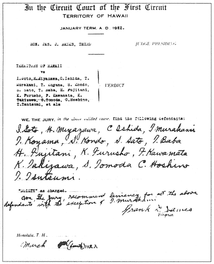
The trial for conspiracy in the first degree began on Wednesday, February 1, 1922, in the First Circuit Court in Honolulu.  Of the twenty-one defendants charged in the indictment, fifteen appeared in court every day. Their names were called each morning at the start of each court session in this order: Goto, Miyazawa, Tsutsumi, Kawamata, Furusho, Hoshino, Takizawa, Baba, Tomota, Ishida, Koyama, Kondo, Sazo, Sato Fujitani and Murakami.  (UC Press)

The indictment read: “On 27th of May 1920, (the accused) did maliciously or fraudulently combine, or mutually undertake or consort together to commit a felony, to wit, to unlawfully use and cause to be exploded dynamite or other explosive chemicals of substance for the purpose of inflicting bodily injury upon one J. Sakamaki.”

It took the jury less than five hours to reach a verdict on the fifteen defendants.

Judge Banks then sentenced all the defendants to “be imprisoned in Oʻahu prison at hard labor for the term of not less than four years nor more than ten years.”  (UC Press)

By the early 1920s many Americans had begun to look at Japan and the Japanese with deep suspicion. Some suggest it was the catalyst for legislation restricting immigration into the US.

The subsequent Johnson Reed Immigration Quota Act ((Immigration Act of 1924) limiting the annual number of immigrants who could be admitted from any country to 2% of the number of people from that country who were already living in the United States in 1890 (down from the 3% cap set by the Immigration Restriction Act of 1921)) passed both houses of Congress with overwhelming majorities: in the House 308 to 58 and in the Senate 69 to 9.

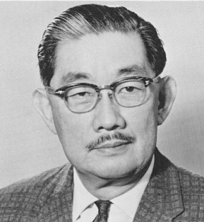
(As an aside, Sakamaki Hall at the University of Hawaiʻi – Mānoa is named for Juzaburo’s son, Shunzo Sakamaki, a prominent administrator and Asian history professor at the University of Hawaii, from 1936 until his retirement in 1970.)

(A controversial aspect of Shunzo Sakamaki’s career concerns his work with the FBI beginning in 1940 aimed at identifying Japanese Americans in Hawaiʻi who should be considered dangerous in the event of war with Japan. While he believed that the vast majority of Japanese Americans in Hawaiʻi were loyal to the United States, he was on record as believing that Shinto priests in Hawaii should be interned.)  (UH-Mānoa)  (Lots of information here from a book by Masayo Umezawa Duus.)

© 2022 Hoʻokuleana LLC

Filed Under: Economy, Prominent People Tagged With: Hawaii Island, Hilo, Olaa Sugar, Juzaburo Sakamaki, Olaa, Hawaii

April 13, 2018 by Peter T Young 9 Comments

Pszyk

Geologic evidence suggests that the modern caldera of Kīlauea formed shortly before 1500 AD. Repeated small collapses may have affected parts of the caldera floor, possibly as late as 1790. For over 300-400 years, the caldera was below the water table.

Kīlauea is an explosive volcano; several phreatic eruptions have occurred in the past 1,200 years. (Phreatic eruptions, also called phreatic explosions, occur when magma heats ground or surface water.)

The extreme temperature of the magma (from 932 to 2,138 °F) causes near-instantaneous evaporation to steam, resulting in an explosion of steam, water, ash and rock – the 1980 eruption of Mount St. Helens was a phreatic eruption.

There were explosions in 1790, the most lethal known eruption of any volcano in the present United States. The 1790 explosions, however, simply culminated (or at least occurred near the end of) a 300-year period of frequent explosions, some quite powerful. (USGS)

Keonehelelei is the name given by Hawaiians to the explosive eruption of Kilauea in 1790. It is probably so named “the falling sands” because the eruption involved an explosion of hot gas, ash and sand that rained down across the Kaʻu Desert. The character of the eruption was likely distinct enough to warrant a special name. (Moniz-Nakamura)

The 1790 explosion led to the death of one-third of the warrior party of Kaʻū Chief Keōua. At the time Keōua was the only remaining rival of Kamehameha the Great for control of the Island of Hawaiʻi; Keōua ruled half of Hāmākua and all of Puna and Kaʻū Districts. They were passing through the Kilauea area at the time of the eruption. (Moniz-Nakamura)

Camped in Hilo, Keōua learned of an invasion of his home district of Kaʻū by warriors of Kamehameha. To reach Kaʻū from Hilo, Keōua had a choice of two routes one was the usually traveled coastal route, at sea level, but it was longer, hot, shadeless and without potable water for long distances. (NPS)

The other route was shorter, but passed over the summit and through the lee of Kilauea volcano, an area sacred to, and the home of, the Hawaiian volcano goddess Pele. Keōua chose the volcano route, perhaps because it was shorter and quicker, with water available frequently. (NPS)

… Fast forward … “Despite the network of Pre-Western contact trails that covered the island, Hawaiʻi lacked a comprehensive system of interior roads for overland travel before 1846.”

“In that year, the Kingdom established the Department of the Interior and the office of Superintendent of Internal Improvements (the forerunner of Public Works) to oversee the construction of piers, harbors, government buildings, roads, and bridges.” (Terry)

Like the times of Keōua, “Two routes may be taken to the crater Kilauea, on the slope of Mauna Loa, one by Puna, the other by ‘Ōla‘a. It will be advisable to combine both, by going one way and returning the other.”

“Time being an object, the trip to and from the crater via ‘Ōla‘a can be accomplished in three days, which will give one day and two nights at the volcano house.” (Whitney, 1875)

“A critical step toward developing agriculture in ʻŌlaʻa was the creation of a new road between Hilo and Kīlauea located mauka of the Old Volcano Trail.” (Terry)

Work on the road began in 1890 using mainly prison labor, and in September of 1894 the entire road was completed. As the new Volcano Road through ʻŌlaʻa was being built, the Crown made a large portion of potential agricultural lands in ʻŌlaʻa available for lease and homesteading.”

“Three hundred eighty-five ʻŌlaʻa Reservation lease lots were created mauka and makai of the new Volcano Road, as well as an additional forty homesteads.” (Terry)

The ‘Ōla‘a Sugar Company was incorporated on May 3, 1899; the promoters purchased 16,000 acres in fee simple land and nearly 7,000 acres in long leasehold from WH Shipman. The plantation fields extended for ten miles along both sides of Volcano Road as well as in the Pāhoa and Kapoho areas of the Puna District.”

‘Ōla‘a Sugar Company began as one of Hawai‘i’s largest sugar plantations with much of its acreage covered in trees. Previous to cane, coffee was the primary agricultural crop grown in the region. After purchase of these lands, the company uprooted the coffee trees and cleared it for planting sugarcane.”

“The town of Mountain View grew with the sugar trade, as immigrant laborers were imported from Japan, Puerto Rico, and the Philippines to work on the sugar plantation.”

“Another lesser known group also came to ʻŌlaʻa. In 1897, the Hawaiian Minister of Foreign Affairs approved a request by H.F Hackfeld and Company (who acted as a recruiting agency for the “Planters Association”) to bring in European laborers for a number of sugar plantations.”

“Between 1897 and 1910, a number of Ukrainian families and single workers were recruited to work for ʻŌlaʻa Sugar Company. Most Ukrainian immigrants left ʻŌlaʻa for the US mainland in 1905 and 1906, but a few remained.” (Terry)

Among those who stayed in Mountain View were Michael and Annie Pszyk. (Terry) They a fifty-acre farm and in addition to work on the plantation they began to clear some land and go into developing a small herds of cows.

It was rather isolated, about 1 ½ miles from the highway. They first blazed a path so that they were able to walk out to Volcano
road.

He then widened it into a trail, but it wasn’t very satisfactory to haul wood to the village for which there was good demand, and take milk and other products.

“My father approached the council to have them make the trail into a road, but there was little interest in such a project.”

“He, eventually, widened the trail himself and made it into a passable road. Then the council took it over and named it Pszyk Road, and rightly so …” (Helen Richardson-Pszyk; Ewanchuck)

Follow Peter T Young on Facebook 

Follow Peter T Young on Google+ 

Follow Peter T Young on LinkedIn  

Follow Peter T Young on Blogger

© 2018 Hoʻokuleana LLC

Pszyk Road Sign
Pszyk Road Sign
View from Olaa-Volcano-Rd-DAGS1665a-1892
Michael Pszyk headstone
Annie Pszyk headstone
Puna_District-DAGS-1808-1893
Olaa-Keaau-Proposed Volcano Road-DAGS1665-1893

Filed Under: Economy, General, Place Names, Prominent People Tagged With: Olaa, Pszyk Road, Ukraine, Mountain View, Hawaii, Olaa Sugar, Hackfeld

March 10, 2015 by Peter T Young 12 Comments

What happened to ʻOlaʻa?

That seems to be the question of some, because in the district of Puna on the Island of Hawaiʻi what once was called Olaʻa is now called Keaʻau. So why did it change?

Let’s look back a bit.

Part of the confusion may be that Olaʻa was formerly called Laʻa, a legendary area for collecting bird feathers. (Ulukau) To further confuse things, some scholars believe that ʻOlaʻa is misspelled, and should be spelled as ʻO-Laʻa.

Some believe that the okina is a substitute for the letter ‘k,’ as it is in some other Polynesian languages, which would, in turn, change the meaning to the name of the hula deity Laka, or a place dedicated (Iaʻa) to the god. (Cultural Surveys)

Laka is the goddess of the upland forests worshiped in the hula dance. (Beckwith) Since Laka is guardian of the forest, her name is invoked by hula dancers and others when entering the forest.

Forests once covered much of ʻOlaʻa; they were later (1905-1928) made part of the forest reserve system within the Islands. The forest lands of ʻOlaʻa were noted for their growth of ʻohiʻa and koa trees, and hapuʻu tree fern.

At the Mahele (1848,) ʻOlaʻa was retained by the Crown. It was described as “A very large land, but cut off from the sea by Keaʻau.” (Cultural Surveys)

Keaʻau (about 60,000-acres of land) is the northern most of some 50 ahupuaʻa (ancient land divisions) found in the district of Puna. Keaʻau extends from the ocean fishery some 26 miles inland, and reaches an elevation of about 3,900-feet – portions of it wrap around the makai point of ʻOlaʻa. In the uplands, Keaʻau is cut off by Keauhou, eastern-most of the ahupuaʻa of the district of Kaʻu. (Maly)

While historically people typically settled along the shoreline, because much of the Puna’s district’s coastal areas have thin soils and there are no good deep water harbors, settlement patterns in Puna tend to be dispersed and without major population centers. Villages in Puna tended inland, and away from the coast, where the soil is better for agriculture. (Escott)

This was confirmed on William Ellis’ travel around the island in the early 1800s, “Hitherto we had travelled close to the seashore, in order to visit the most populous villages in the districts through which we had passed. But here receiving information that we should find more inhabitants a few miles inland, than nearer the sea, we thought it best to direct our course towards the mountains.” (Ellis, 1826)

“Nearly all the food consumed by the residents of this District is raised in the interior belt to which access is had by the ancient paths or trails leading from the sea coast. The finest sweet potatoes are raised in places that look more like banks of cobble stones or piles of macadam freshly dumped varying from the size of a walnut to those as large as ones fist. In these holes there is not a particle of soil to be seen”. (Alexander; Rechtman)

What is consistent and clear from testimony before the Land Commission, there definitely was an Olaʻa in upper Puna on the Island of Hawaiʻi. The testimony is equally consistent and clear that there also was a Keaʻau.

Thrum, in his 1894 Hawaiian Almanac and Annual, noted, “The year 1894 witnessed the completion of the volcano road which was begun in 1889. This is a boon to visitors and the settlers in the new coffee district of ʻOlaʻa, as it affords a fine carriage drive the entire distance of thirty miles. Regular stages now run between Hilo and the Volcano House every other day.”

A common reference relates to the old road to Volcano, “ʻOlaʻa (is) on the Hilo side of the road and Keaʻau on the Puna side.” Others phrased it “ʻOlaʻa being on the North side of the road and Keaʻau on the South east side.”

“ʻOlaʻa has come into prominence in the past few years as a most promising coffee center. The opening of the road from Hilo to the volcano, which traverses this neighborhood, was the means of bringing the possibilities of the ʻOlaʻa lands to public notice as well as within reach.” (Thrum, 1898)

So, what happened with the ʻOlaʻa – Keaʻau name changes?

Before 1900, coffee was the chief agricultural crop in the area. Over 6,000-acres of coffee trees were owned by approximately 200-independent coffee planters and 6 incorporated companies.

Soon, sugarcane was in large-scale production. Initially founded in 1899, ʻOlaʻa Sugar Company leased about 4,000-acres of land, expanded and eventually became the dominant operation in the region. Plantation fields extended for 10-miles along both sides of Highway 11 between Keaʻau and Mountain View, as well as in the Pāhoa and Kapoho areas.

Construction of centrally-located ʻOlaʻa Sugar Mill was completed in 1902, requiring 51 men working a three-shift operation. This industrial expansion marked the beginning of massive landscape alterations and clearing operations.

A community grew around the plantation. Attention to employee welfare was demonstrated by ʻOlaʻa Sugar Company in the housing program, free medical attention and recreational facilities. ʻOlaʻa modernized the housing by building new family units and relocating outlying houses scattered about the plantation into nine main villages.

They became miniature towns with running water, electric lights, schools, churches, stores, clubhouses, theaters, parks and ball fields. The plantation roads radiated from these nine camps to cover the cane areas where the men worked. The 1930 plantation census noted a total of 5,999-men, women and children residing in 1,098-houses at ʻOlaʻa. (HSPA)

The plantation made land available for community uses. As examples, the ʻOlaʻa Hongwanji was built in 1902. Likewise, ʻOlaʻa Christian Church was nearby. ʻOlaʻa School, an elementary school, began in 1939. Other groups and places were formed using the ʻOlaʻa namesake.

That changed … and, it’s not clear how or when the mistake was learned.

But a 1951 article in The Friend paper reported part of the reasoning for subsequent name changes. “At an impressive ceremony, more than 250 members and friends of the church gathered to witness the old ʻOlaʻa Christian Church become the new Keaʻau Congregational Church.”

“The name-changing and rededication ceremony took place on the night of April 10, 1951, at the ʻOlaʻa Christian Church …. The Christian assertion, ‘God is Truth,’ is no mere, pious assertion designed to conceal their inner fear of truth nor their secret attachment to falsehood.”

“Christians are incurably truthseekers. Thus when the members of our church learned that the original and correct name of the village in which the church is situated is Keaʻau and not ʻOlaʻa, they felt that the time had come when they should change the name of the church.” (The Friend, June 1, 1951)

Others followed.

In 1960, ʻOlaʻa Sugar Company became Puna Sugar Company. ʻOlaʻa Elementary School became Keaʻau Elementary and Intermediate School (later Keaʻau Middle School.) In the early-1970s, ʻOlaʻa Hongwanji became Puna Hongwanji.

Not all early labels and references were incorrect; a 1914 USGS map appears to correctly label the place once known as ʻOlaʻa as Keaau.

Follow Peter T Young on Facebook 

Follow Peter T Young on Google+ 

Follow Peter T Young on LinkedIn  

Follow Peter T Young on Blogger

© 2015 Hoʻokuleana LLC

Olaa-Keaau-Some_Name_Changes-GoogleEarth
Puna_District-DAGS-1808-1893
Olaa-Keaau-Hilo-GoogleEarth
View from Olaa-Volcano-Rd-DAGS1665a-1892
Olaa-Keaau-Proposed Volcano Road-DAGS1665-1893
Olaa School Token
Olaa School Token
Olaa_Sugar_Mill-kuokoa-01_20_1905
Puna Hongwanji
Puna Hongwanji
Olaa Hongwanji
Olaa Hongwanji
Puna_Hongwanji
Puna_Hongwanji

Filed Under: Economy, Place Names Tagged With: Olaa Sugar, Olaa, Keaau, Puna Sugar, Hawaii, Hawaii Island, Puna

November 13, 2014 by Peter T Young 1 Comment

Puna

Prior to Western contact, each of the major islands or independent chiefdoms in the Hawaiian chain comprised a mokupuni (island.) Over the centuries, as the ancient Hawaiian population grew, land use and resource management also evolved.

Each island was divided into several moku or districts, of which there are six in the island of Hawaiʻi, and the same number in Oʻahu. There is a district called Kona on the lee side and one called Koʻolau on the windward side of almost every island.  (Alexander)  Another moku (common on a couple mokupuni) is Puna (“well-spring”) – this summary is about Puna on Hawaiʻi Island.

Puna was once known for its groves of hala and ʻōhiʻa-lehua trees.  Hawaiians observed, “Ka ua moaniani lehua o Puna / The rain that brings the fragrance of the lehua of Puna”.

This ʻōlelo noʻeau refers to the forests of Puna, which attract clouds to drench the district with many rains, refreshing and enriching the Puna water table, and sustaining the life cycle of all living things in Puna.

While the Puna district does not have running streams, it does have many inland and shoreline springs continuously fed by rains borne upon the northeast tradewinds. (McGregor)

In Nā Mele o Hawaiʻi Nei, the reference “Puna paia ʻala i ka paia ʻala i ka hala,” is translated as “Puna of the fragrant bowers, fragrant with the blossoms of the hala” (pandanus.)  (King, 1938)

According to Pukui, in the olden days, people would stick branches of hala into the thatching of their houses to bring some of the fragrance indoors.

“Puna on Hawaiʻi Island was the land first reached by Pāʻao, and here in Puna he built his first heiau for his god Ahaʻula and named it Ahaʻula (Wahaʻula.)  It was a luakini (large heiau where human sacrifice was offered.)  From Puna, Pāʻao went on to land in Kohala, at Puʻuepa. He built a heiau there, called Moʻokini.”  (Kamakau; McGregor)

According to Kamakau, the Island of Hawaiʻi was without a chief when Pāʻao arrived in Hawaiʻi in the eleventh century.  Evidently the chiefs of Hawaiʻi were considered aliʻi makaʻāinana (commoner chiefs) or just commoners, makaʻāinana, during this time.

Pāʻao sent back to Tahiti for a new ruler for Hawaiʻi, thereby ushering in a new era of ruling chiefs and kāhuna for the Hawaiian archipelago. The new ruler was Pili-kaʻaiea, from whom King Kamehameha I eventually descended.  (McGregor)

One story tells that Hāʻena, a small bay near the northern boundary of Puna, is said to be the birthplace of hula.  The goddess Hiʻiaka is said to have been instructed to dance hula on the beach there.  Puna is said to inspire hula because of the natural movements of waves, wind and trees. (Other stories suggest hula was started in other areas of the Islands.)

Early settlement patterns in the Islands put people on the windward sides of the islands, typically along the shoreline.  However, in Puna, much of the district’s coastal areas have thin soils and there are no good deep water harbors. The ocean along the Puna coast is often rough and windblown.

As a result, settlement patterns in Puna tend to be dispersed and without major population centers. Villages in Puna tended to be spread out over larger areas and often are inland, and away from the coast, where the soil is better for agriculture.  (Escott)

This was confirmed on William Ellis’ travel around the island in the early 1800s, “Hitherto we had travelled close to the sea-shore, in order to visit the most populous villages in the districts through which we had passed. But here receiving information that we should find more inhabitants a few miles inland, than nearer the sea, we thought it best to direct our course towards the mountains.”  (Ellis, 1826)

Alexander later (1891) noted, “The first settlement met with after leaving Hilo by the sea coast road, is at Keaau, a distant 10 miles where there are less than a dozen inhabitants; the next is at Makuʻu, distant 14 miles where there are a few more, after which there is occasionally a stray hut or two, until Halepuaʻa and Koaʻe are reached, 21 miles from Hilo, at which place there is quite a village”.

“Nearly all the food consumed by the residents of this District is raised in the interior belt to which access is had by the ancient paths or trails leading from the sea coast. The finest sweet potatoes are raised in places that look more like banks of cobble stones or piles of macadam freshly dumped varying from the size of a walnut to those as large as ones fist. In these holes there is not a particle of soil to be seen”.  (Alexander; Rechtman)

Puna was famous as a district for some of its valuable products, including “hogs, gray tapa cloth (‘eleuli), tapas made of mamaki bark, fine mats made of young pandanus blossoms (‘ahuhinalo,) mats made of young pandanus leaves (ʻahuao,) and feathers of the ʻoʻo and mamo birds”.  (Kamakau; McGregor)

An historic trail once ran from the modern day Lili‘uokalani Gardens area to Hāʻena along the Puna coast. The trail is often referred to as the old Puna Trail and/or Puna Road. There is an historic trail/cart road that is also called the Puna Trail (Ala Hele Puna) and/or the Old Government Road.

It likely incorporated segments of the traditional Hawaiian trail system often referred to as the ala loa or ala hele.  The full length of the Puna Trail, or Old Government Road, might have been constructed or improved just before 1840. The alignment was mapped by the Wilkes Expedition of 1804-41.  (Escott)

With Western contact, extensive tracts of Puna’s landscape were transformed, first with sandalwood export began in 1790, reaching its peak between 1810 and 1825.

After Hawai‘i’s first forestry law in 1839 restricted the removal of sandalwood trees, cattle ranching and coffee cultivation became the leading commercial activities. By 1850, agriculture diversified with the cultivation of potatoes, onions, pumpkins, oranges and molasses.

Before 1900, coffee was the chief agricultural crop in the area. Over 6,000-acres of coffee trees were owned by approximately 200-independent coffee planters and 6 incorporated companies.

Soon, sugarcane was in large-scale production. The dominant operation in Puna was the Puna Sugar Company, whose plantation fields extended for ten miles along both sides of Highway 11 between Keaʻau and Mountain View, as well as in the Pāhoa and Kapoho areas.

Initially founded in 1899 as Olaʻa Sugar Company, it was later (1960) renamed Puna Sugar Company. The coffee trees were uprooted to make way for sugarcane. ʻŌhiʻa forests also had to be cleared, field rock piled, land plowed by mules or dug up by hand with a pick. Sugarcane was in large-scale production; the sugar mill operation ran for just over 80 years, until 1984.

Macadamia nuts and papaya were introduced in 1881 and 1919, respectively. Since the closure of the Puna Sugar Company, papaya and macadamia nut production have become the leading crops of Puna.  About 97% of the state’s papaya production occurs in Puna, primarily in the Kapoho area.

Another thing growing in Puna is housing.  Between 1958 and 1973, more than 52,500-individual lots were created.  There are at least over 40-Puna subdivisions.

As a comparison, Oʻahu is about 382,500-acres in size; the district of Puna on the island of Hawaiʻi is about 320,000-acres in size – almost same-same.

According to the 2010 census, Oʻahu has about 955,000-people and Puna has about 45,500.  That means there are less than a half-acre per person on Oʻahu and over 70-acres per person in Puna.

However, in Puna, they plotted out the subdivisions in cookie-cutter residential/agricultural lots across a grid, with very little space for other uses (such as parks, open space, government services, regional roads … the list goes on and on.)

Likewise, most subdivision lots are accessed by private, unpaved roads. The streets generally lack sidewalks and lighting, and do not meet current County standards in terms of pavement width, vertical geometrics, drainage and other design parameters.

There are only two main roads to move the people in the district in and out – one (Route 130 – Keaau-Pahoa Road) goes into Pahoa to Kalapana; the other (Route 11 – Volcano Highway) serves the lots up in the Volcano area.  (Lots of information here from the Puna Community Development Plan.)

I was saddened when the news broadcast the first house lost to the ongoing lava flow – a home of a friend and former student from Parker School.

I have been debating about posting on Puna – but decided that as the lava flows there, we should reflect on its history, but also be sensitive to and respectful of the trauma facing many of the families there – they are going through situations many of us will never have to face.

The image shows the Wilkes 1840-1841 map of Puna.  In addition, I have added others similar images in a folder of like name in the Photos section on my Facebook and Google+ pages.

Follow Peter T Young on Facebook  

Follow Peter T Young on Google+ 

Follow Peter T Young on LinkedIn   

© 2014 Hoʻokuleana LLC

Filed Under: Place Names Tagged With: Hawaii, Hawaii Island, Volcano, Puna, Hula, Paao, Olaa Sugar

Images of Old Hawaiʻi

People, places, and events in Hawaiʻi’s past come alive through text and media in “Images of Old Hawaiʻi.” These posts are informal historic summaries presented for personal, non-commercial, and educational purposes.

Info@Hookuleana.com

Connect with Us

  • Email
  • Facebook
  • LinkedIn
  • Twitter
  • YouTube

Recent Posts

  • Teshima’s
  • Waikīkī’s Construction Evolution
  • A Building Tells Stories About Buildings
  • Saint Patrick’s Day
  • No Taxation Without Representation
  • Ka Iwi
  • Hāmākua in the 1880s

Categories

  • General
  • Ali'i / Chiefs / Governance
  • Buildings
  • Missionaries / Churches / Religious Buildings
  • Hawaiian Traditions
  • Military
  • Place Names
  • Prominent People
  • Schools
  • Sailing, Shipping & Shipwrecks
  • Economy
  • Voyage of the Thaddeus
  • Mayflower Summaries
  • American Revolution

Tags

1915 Albatross Babe Ruth Battery Salt Lake Body of Liberties Collegia Theatre David Howard Hitchcock Department of Hawaiian Home Lands Diamond Head H-4 Hale O Lono Happy New Year Howard Kaleohano James Hay Wodehouse James Lord Pierpont Julian Calendar Kailua Airfield Kamanawa Kamehameha V Kona Field System Kukaniloko Kuleana Labor Union Laplace Louis Pohl Lunalilo Home Mao Merchant Street Na Pali National Construction New World Norman Keith Collins Oliver Cromwell Picture Bride Presidents' Day Quaker Resolution Right Samuel Damon Sir Humphrey Gilbert Sometaro Shiba Sperm Whale St Anthony Tea William Reed

Hoʻokuleana LLC

Hoʻokuleana LLC is a Planning and Consulting firm assisting property owners with Land Use Planning efforts, including Environmental Review, Entitlement Process, Permitting, Community Outreach, etc. We are uniquely positioned to assist you in a variety of needs.

Info@Hookuleana.com

Copyright © 2012-2021 Peter T Young, Hoʻokuleana LLC


Loading Comments...