Images of Old Hawaiʻi

  • Home
  • About
  • Categories
    • Ali’i / Chiefs / Governance
    • American Protestant Mission
    • Buildings
    • Collections
    • Economy
    • Missionaries / Churches / Religious Buildings
    • General
    • Hawaiian Traditions
    • Other Summaries
    • Mayflower Summaries
    • Mayflower Full Summaries
    • Military
    • Place Names
    • Prominent People
    • Schools
    • Sailing, Shipping & Shipwrecks
    • Voyage of the Thaddeus
  • Collections
  • Contact
  • Follow

October 17, 2024 by Peter T Young Leave a Comment

Nāuhi Cabin

The early Polynesian settlers to Hawaiʻi brought sugar cane with them and demonstrated that it could be grown successfully in the islands.

Fast forward … Hawai‘i’s economy turned toward sugar in the decades between 1860 and 1880; these twenty years were pivotal in building the plantation system.

Sugar‐cane farming gained this prestige without great difficulty because sugar cane soon proved to be the only available crop that could be grown profitably under the severe conditions imposed upon plants grown on the lands which were available for cultivation.  (HSPA 1947)

In 1876, the legislature of Kamehameha III passed a law declaring all “forest lands” to be government property in an effort to conserve the forests from further encroachment on the seaward side by the plantations’ need for fuel and on the mountain side from grazing animals.

Founded in 1895, the Hawaiian Sugar Planters’ Association (HSPA), dedicated to improving the sugar industry in Hawai‘i, has become an internationally recognized research center.  (It was in 1996 when HSPA expanded its research interest besides sugarcane and acquired its current name Hawai‘i Agriculture Research Center (HARC), expanding its research on tropical crops and forests.)

Interestingly, it was the sugar growers, significant users of Hawai‘i’s water resources, who led the forest reserve protection movement.  On May 13, 1903, the Territory of Hawaiʻi, with the backing of the Hawaiʻi Sugar Planters’ Association, established the Board of Commissioners of Agriculture and Forestry.  (HDOA)

The Forest Reserves were established as a cooperative arrangement between the Hawaiʻi Sugar Planters Association and the territorial government.

Plantations needed wood for fuel, but they also needed to keep the forests intact to draw mist precipitation from the trade winds, which in turn fed the irrigation systems in the cane fields below.

Their own consumption of fuel had clearly been contributing to the decline of the forest at lower elevations, where flume systems transported large quantities of wood, as well as cane.  (Mills)

The link between tree-planting and the sugar planters can be seen particularly clearly in the career of Harold Lyon, who arrived in Hawai‘i in 1907 as a plant pathologist in the employ of the Hawaiian Sugar Planters’ Association (HSPA).

Lyon was a strong voice for forests; neglect of the islands’ forests would be “suicidal,” for ‘‘everything fails with the failure of our water supply’’.

Johnny Ah San, who worked as a territorial forester, noted, “And then HSPA had a man down at Nāuhi Nursery, and they planted trees. Then before the war [WWII], Roosevelt had the WPA [Works Progress Administration], so the men planted trees in the forest.” (Johnny Ah San; Maly)

The Nāuhi (‘the yams’) facility was interchangeably referred to as a Nursery and Experimental Station (and, apparently, also called Nāuhi Camp). The Hilo Forest Reserve was the site of cooperative reforestation efforts by the HSPA and Territorial foresters and later by the Civilian Conservation Corps under the direction of the Bureau of Forestry.

Over 100 varieties of temperate trees and plants were tested at the Experiment Station at Nāuhi; many of which succeeded to the point of naturally reproducing.

Nāuhi Cabin (a small building with three out-structures) was part of the Nāuhi Gulch Experiment Station, which was established in 1924. It is located in the ahupua‘a of Honohina at about 5,100 feet above sea level.  A nursery that was part of the Experiment Station is no longer standing. (Tuggle)

The purpose of Nāuhi Gulch Experiment Station, which operated until the beginning of World War II, was to “introduce, propagate and plant out in the adjacent forest lands various species and varieties of temperate zone, both northern and southern, trees and other plants”.

To this end, over 78 varieties of fruit trees and over 30 varieties of other temperate zone trees and plants were tested. Surrounding the cabin now is a wild landscape of feral garden flowers like roses, daisies, and nasturtiums, as well as apple, pear, and plum trees.

In 1941, wild pigs in the Nāuhi gulch-Pihā area were noted by Lyon: “Of special interest to us at this time are your remarks regarding the prevalence of wild hogs in the Nāuhi Gulch-Pihā region. They undoubtedly do a great deal of damage there.”

“If, for any reason, this Territory is compelled to produce its own food supply, we could organize a campaign which would remove most of these hogs from the forest and, at the same time, yield a goodly amount of excellent food for our people.” (Tuggle)

The cabin was part of a complex that included several buildings and an orchard on 47 acres of land leased from Lili‘uokalani Trust. In 1945, Territorial forester Bryan reported on the conditions at the by-then abandoned station (Bryan 1945):

“There has been no work done at this station for a considerable period of time, and it is in a run-down state at the present time. Fences are in need of repairs, wild pigs are numerous and have done some damages in the orchard, and it will require considerable labor and effort to bring it back to its former appearance.”

Nāuhi Cabin has been used by the National Biological Survey. Formed in 1993, their mission was to gather, analyze, and disseminate the biological information necessary for the sound stewardship of natural resources and to foster understanding of biological systems and the benefits they provide to society. It is now known as USGS’s Biological Resource Division (BRD).

© 2024 Ho‘okuleana LLC

Filed Under: Place Names, Economy, General Tagged With: Hawaii, Hilo, Hakalau Forest National Wildlife Refuge, Nauhi Cabin

October 14, 2024 by Peter T Young Leave a Comment

Boiling Pots

There are two rivers in the Hawaiian Islands bearing the name of Wailuku. One is on the Island of Maui, flowing out of a deep gorge in the side of the extinct volcano ‘Īao. The other Wailuku River is on the Island of Hawaii.

The Wailuku is the longest river in Hilo (twenty-six miles.) Its course runs from the mountains to the ocean. The Wailuku is the boundary between Hilo Palikū in the north and Hilo One on the south.

Hawaiians were impressed by this Wailuku and wove a dramatic tale around several interesting geologic features within the river.

Hina, the moon goddess and mother of Maui, lived in the cave beneath Rainbow Falls, concealed by the mist of the falls. Each day she beat and dried her kapa in the sun.

Far above the cave, in the bed of the river, dwelt Kuna. [Kuna is a variety of freshwater eel [or Mo‘o (dragon)] said to have been introduced from abroad. (Parker)]  That portion of the river runs bears to this day the name ‘Waikuna’ or ‘Kuna’s river.’

Kuna often tormented Hina by sending over great torrents of water or by rolling logs and boulders down the stream. This would block the stream below the falls to dam the river and drown Hina.

Hina was frequently left with but little protection, and yet from her home in the cave feared nothing that Kuna could do. Precipices guarded the cave on either side, and any approach of an enemy through the falling water could be easily thwarted.

During a particularly intense storm, Mo‘o Kuna moved a huge boulder over the falls and into the river, where it fit perfectly and prevented water from flowing farther. Water level beneath the falls began to rise.

Hina, realizing her danger, signaled her son. With two powerful strokes, he paddled his canoe from Maui to the mouth of the Wailuku. He rushed upstream and split the damming boulder with a single blow, thereby saving his mother.

By this time, Kuna had fled upstream. Maui found Kuna hiding in a hole beneath the river. He tried to spear Kuna, but Kuna escaped. Finally, Kuna found deep hiding holes and thought to be safe.

Maui again found Kuna and called upon Pele to send lava into the river to drive out Kuna.  The red-hot burning stones in the water made the pools boiling and the steam was rising in clouds – Kuna uttered incantation after incantation, but the water scalded and burned Kuna.

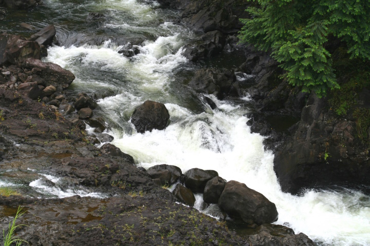
Kuna leaped from the pools and fled down the river. The waters of the pools are no longer scalding, but they have never lost the tumbling, tossing, foaming, boiling swirl which Maui gave to them when he threw into them the red-hot stones with which he hoped to destroy Kuna, and they are known today as the ‘Boiling Pots.’  (Westervelt, USGS)

Despite the name, the water is not normally hot. The only time in the modern history of the river that the water was heated was in 1855 and 1856 when a lava flow from Mauna Loa advanced across the Saddle between that volcano and Mauna Kea. Lava flowed into the Wailuku River channel, but did not cross it, about 4 miles above the Boiling Pots. (BIVN)

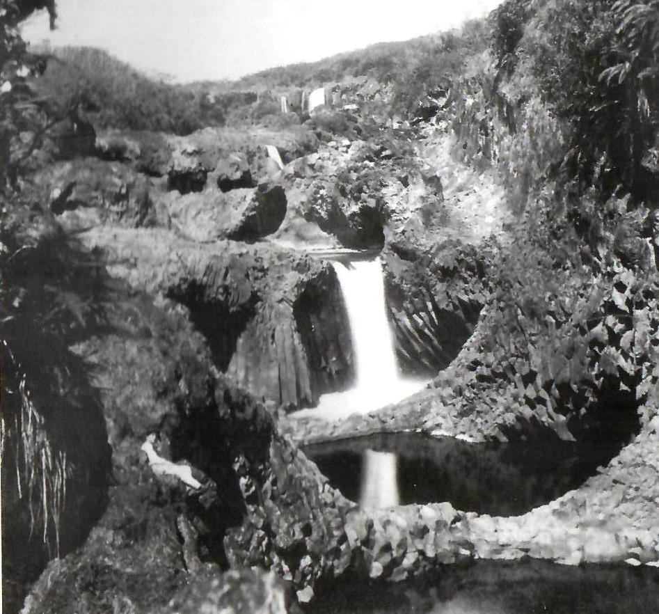
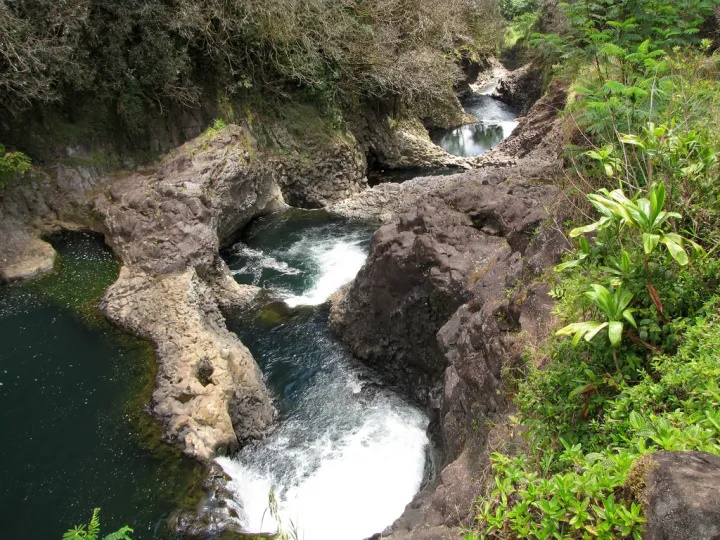
The Boiling Pots is about 1.5 miles upstream from Rainbow Falls and is a succession of eroded, hollowed out terraced pools that fill with the flow of the river. When the river is engorged with storm runoff, the ‘pots’ fill to the brim, become turbulent and appear to ‘boil.’  (HawaiianAir)

The Wailuku River is an important landmark to geologists, because it marks the approximate boundary between the lava flows of Mauna Kea and Mauna Loa. It is the state’s longest river and the southernmost that carries water all year.

According to the USGS, the river was formed by at least two lava flows coming from Mauna Kea, the oldest, the ‘Anuenue flow (as old as 10,500 years), is the same flow that formed the thick lip of Rainbow Falls and most of the rounded, gray boulders at Boiling Pots.

Tracing the flows up and down the Wailuku tells a geologic story of a river that had already deeply cut into Mauna Kea and Mauna Loa flows when it was filled by the ‘Anuenue flow over 10,000 years ago. Many of these boulders are frozen into a younger pahoehoe flow, named after the Punahoa ahupua‘a and about 3,100 years old.

The filling caused the river to shift in many places and resume its erosional downcutting before lava again ventured into the river 3,100 years ago. (The Hawaiian and the geologic versions of the Wailuku River story have many similarities, including the pools – ‘pots.’ (USGS)

The pots, each about 50-feet in diameter, are eroded into the 10,500 year old Mauna Loa lava flow. When the water is low, the river does not flow over some of the pot rims but it continues to flow through them. (USGS)

An average of 275-million gallons of water flows through the Wailuku to Hilo daily – during intense storms, the discharge can be more than 20 times greater. On average, the Wailuku transports approximately 10 tons of suspended sediment into Hilo Bay each day.

About a half mile up the river from the boiling pots is Peʻepeʻe Falls.  Waiānuenue Avenue (rainbow (seen in) water) is named for the most famous waterfall, Ka Wailele ʻO Waiānuenue, Rainbow Falls on the Wailuku River.

DLNR operated the Wailuku River State Park, here. There are two separate park areas, Boiling Pots and Rainbow Falls. Flash flooding is common, and because there are no lifeguards, many have perished in the river by getting sucked into the water and becoming trapped within concealed lava tubes and caves.

The best way to experience this beautiful and deadly natural phenomena is from a cement overlook, just a short walk from the paved parking lot.

© 2024 Ho‘okuleana LLC

Filed Under: General, Place Names Tagged With: Hawaii, Hilo, Wailuku River, Boiling Pots

September 9, 2024 by Peter T Young Leave a Comment

Cow Palace

“It was built in 1916 by a Hackfeld & Co as a lumber warehouse. The firm later was sold to the American Factors, now Amfac, and the building continued to be a warehouse until World War II. … It endured the 1946 and 1960 tidal waves.” (HTH, April 14, 1970)

“Anyone who looks at the modified false front of the building, which stores in those days thought necessary to identify themselves, can read the date 1916 near the top and the faded inscription ‘American Factors Ltd.’ below it.”

“It was a proud building in those days and a big one for Hilo. The train which ran just sea ward of the building ran its freight cars on special tracks to the Hamakua side of the building to unload merchandise onto the broad lanai which runs the length of the building.”

“Another track led to the extensive lumber yard on the opposite side of the building. Here the lumber was piled by hand in neat stacks under an open sided shed which protected the clean smelling lumber from sun and rain yet let the air play through.”

“This building and the one now housing Koehnen’s store at Waianuenue and Kamehameha Avenues in Hilo were the chief warehouse facilities on this island for American Factors, Ltd., now known as Amfac Inc.” (Baldwin, HTH July 28, 1969)

“During the war, the building was turned into a recreation center for servicemen and acquired the nickname, ‘Cow Palace.’ Ever since, the Cow Palace has been the official name for the building.”  (HTH, April 14, 1970)

“The ‘Cow Palace’ building housed hardware, general building supplies, farm equipment, etc., and had its own office. The uptown one stored dry goods, drugs and sundries on its top floor; office space, groceries and general merchandise on its main floor, and larger items and crated goods in Its basement.” (Baldwin, HTH July 28, 1969)

“We have been renting the waterfront property on a permit issued to us by the Commissioner of Public Lands since February 1, 949. An Indenture of Exchange was made between the Territory of Hawaii and American Factors on May 17, 1949 …”

“… in which our waterfront properties were exchanged for a parcel of land in the Waiakea area. Here a lumberyard was established and a mill erected and an area cleared for the erection of a warehouse.”

“In the early part of 1950 we were advised by the Territory to vacate one end of our building to make way for the highway through the Hilo waterfront. This received our immediate attention.”

“On August 21, 1951, Frank G. Serrao, then Commissioner of Public Lands, gave us a copy of a letter [that states] ‘I wish to assure you that the American Factor warehouse and the surrounding premises on Kamehameha Avenue, Hilo, Hawaii …”

“… will be made available to the County of Hawaii within two years.’ This would indicate that we could continue our tenancy into 1953.” (EG Solomon, President of American Factors)

Then, “The old American Factors warehouse in the bayfront zone is going to be given some repairs and turned into a band practice hall and recreation department center.”

“After repairs are completed, members of the county band will hold their practice sessions there. Currently, they practice in their old facility on Kaiulani street.”

“Offices of the Hilo recreation committee will move into the old Amfac building from Piihonua gymnasium, which is being used now. Summer program indoor activities will also be held in the repaired bayfront facility. (HTH, June 9, 1954) It “became a sports center of the County Department of Parks and Recreation.”

“Until a roof cave-in last February [from significant heavy rains], Cow Palace was home for the County Band and several civic organizations. … But now it is coming down as required by the County General Plan.” (HTH, April 14, 1970)

© 2024 Ho‘okuleana LLC

Filed Under: Economy, Buildings Tagged With: Hawaii, Hilo, Cow Palace

September 5, 2024 by Peter T Young Leave a Comment

Hilo Gas

“Hawaii … has two public-utility gas companies, the first having been incorporated April 15, 1903 for the purpose of supplying Honolulu with a manufactured supply of gas for fuel and illuminating purposes.”

“Ten years later, the second utility, the Hilo Gas Company was incorporated, and a franchise was obtained for manufacturing and supplying gas in the district of South Hilo on the Island of Hawaii.” (Historic Inventory of the physical, social and economic, and industrial resources of the Territory of Hawaii, 1939)

“Hilo Gas Company Formed – Articles of incorporation of the Hilo Gas Company, Ltd, were filed with the territorial treasurer yesterday, the capital stock being given as $100,000.  Bids for the erection of a gas plant have already been advertised for by the company and the contract will be let the latter part of this month.” (Hawaiian Gazette, January 5, 1917)

One of the incorporators and President of the new Company was Peter Carl ‘Pete’ Beamer, “who became the patriarch of a famous music and hula clan in Hawaii”. (Downey, Civil Beat)

Hilo Gas “was engaged as a public utility in the manufacture and distribution of gas in the City of Hilo and in the nonutility business of distributing bottled liquefied petroleum gas outside of the city.” (Hawaiian Trust Co. v. United States, 1961)

Over the years, this facility manufactured water gas [a kind of fuel gas], butane, and propane. Their facility was on Ponahawai street, down by Kamehameha Highway; Hilo Gas Company constructed its original oil-gas facility on the site in 1917.

“By 1935, the facility could produce 120,000 cubic feet of gas in eight hours. The facility was upgraded periodically, and over the years included a 45,000-gallon capacity above ground fuel storage tank, two 52,000-cubic foot gas holder tanks, a gas generator, a water filter, a scrubber tower, storage tanks, gas purifiers and pressurized gas cylinders.”

“The manufactured gas process was reportedly operated 24 hours per day and involved the injection of pre-heated crude oil and steam in a fire brick-lined gas generator to produce the raw gas. The crude oil was delivered to the site by rail car and stored in the 45,000-gallon storage tank.” (Weston)

“In 1948 and 1949 Hilo Gas lost money and was in financial difficulties. In the spring of 1950, Orlando Lyman, its president and largest stockholder, approached AE Englebright, the general manager of [Pacific Refiners], for assistance in solving the problems of Hilo Gas.”

“It was first proposed that Hilo Gas should cease the manufacture of gas and buy butane from Refiners, thus saving manufacturing costs. Further negotiations, in which alternative plans were considered, proved unsuccessful.”

“About the middle of September, 1950, Lyman offered to sell his shares of Hilo Gas to Refiners or Honolulu Gas. With his stock and that of another stockholder who was willing to sell, Refiners could acquire in excess of 75% of Hilo’s stock.”

“The original plan of Refiners as controlling stockholder of Hilo Gas had been to sell the utility assets to Honolulu Gas and dissolve Hilo Gas at such a time as the directors determined to be convenient.”

“On September 27, 1950, the directors of Honolulu Gas authorized the acquisition of the assets of Hilo Gas … subject to the approval of the Public Utilities Commission.” (Hawaiian Trust Co. v. United States, 1961)

“Purchase of the recently organized Pacific Refiners, Ltd is the first step in moves which will ultimately lead to acquisition of the Hilo utility firm by the Honolulu Gas Co.” (HTH Oct 7, 1950)

“‘The purchase by Pacific Refiners and ultimately by Honolulu Gas Co. means in effect,’ Mr. Lycurgus asserted, ‘the investment of some 2,500 gas consumers in over a quarter of a million dollars in gas appliances has been saved.’ Better utility service and lower rates sum up the ultimate effects of the purchase, according to Mr Lycurgus.” (HTH Oct 7, 1950)

On May 22, 1960, a tsunami struck Hilo town, destroying many homes and businesses, and claiming 61 lives while causing $24 million in damage. The Hilo Gas Company facility was destroyed. 

Following the disaster, the State of Hawaii assumed ownership of the parcel and designated it part of a tsunami buffer zone. Hilo Gas Company relocated to an inland site and recommenced operations in 1962.  (Weston)

In 1960, “The gas-fired luau torch, developed by Honolulu Gas Co, has been accepted for patent by the US Patent Office … Gasco engineers first developed it in 1953, and have since made refinements.”

“The company says thousands now are used in Honolulu, and that a ‘considerable quantity’ is sold on the Mainland … Queen’s Surf had the first major installation here.” (Adv Dec 3, 1960)

What was Hilo Gas is now a part of The Gas Company, LLC dba Hawaii Gas.  The Gas Company has grown to serve Oahu, Hawaii, Maui, Kauai, Molokai, and Lanai. (Legislature)

(In 1997 folks found that the former Hilo Gas site was contaminated with Poly Aromatic Hydrocarbons (PAHs), Volatile Organic Compounds (VOCs), and sulfide compounds stemming largely from Hilo Gas Company’s former activity on-site.)

(In response, the US Army Corps of Engineers (USACE) encapsulated and removed the contaminated soil in a plastic liner resembling a ‘burrito.’ The burrito was left near the site until 2004 when Hawai‘i Health Department, USACE, and the County of Hawai‘i removed the extracted soil encapsulated in the burrito and the additional soil from the second portion of the site. (EPA))

© 2024 Ho’okuleana LLC

Filed Under: Buildings, Economy Tagged With: Hawaii, Hilo, Hilo Gas, Luau Torch

August 24, 2024 by Peter T Young Leave a Comment

Pipe Line

An image posted on the ‘History of Hawaii Island (The Big Island) in photos’ Facebook page caught my eye. It is an aerial image of a portion of Hilo Bay from NARA (National Archives and Records Administration).

It showed and was labeled ‘Pipe Line, Hilo Harbor, Hawaii, TH, 6 August 1935’. It looked like a pier going out into the bay coming off of Downtown Hilo. I had never seen this before on any images or maps, and certainly did not know what it was.

The land-based connection of the pier was at the northern end of Kaipalaoa (also known as Mokupane and Isabel Point). I had just researched that area of Hilo and there was never any mention of a pier, nor any mapping or photos of it … until now.

Looking at nautical charts, the ‘pier’ extended from the fringing, shallower part of the Bay to the drop-off. Initial thoughts suggested the ‘pipe line’ may mean it was a fueling line (that offshore ships could refuel or it could be a place for ships to offload fuel for the city).

(Somewhat supporting this idea, starting in 1917, Hilo Gas had a manufacturing facility nearby on Ponahawai Street that produced liquid gas from crude oil for local industrial, lighting, and cooking needs.  By 1935, the facility could produce 120,000 cubic feet of gas in eight hours.  (The plant was destroyed by the May 22, 1960 tsunami.) (Weston))

After further review, it was clear the fuel alternatives – either supplying ships or off-loading from ships – were not viable (there was no land-based evidence of fuel storage in the vicinity).

Then, the prospect of something relating to wastewater disposal came up. Initially, a subtle reference to ‘Sewage Sys’ (and very small square near the railroad track) on the land was noted on a map.

Further investigation led to more information about the ‘pier’ and ‘pipe line’ led to the conclusion that the ‘pier’ in the image was associated with sewer improvements in Hilo.

The word “Sewer” is derived from the term “seaward” in Old English, as in ditches and ravines slightly sloped to run waste water from land to sea.

From an 1857 story in the Commercial Pacific Advertiser it appears that the first sewer facility to be constructed on Oʻahu was a storm drain located at Queen Street at the foot of Kaʻahumanu Street opposite Pier 11.  (ASCE)

Despite three outbreaks of smallpox, a typhus epidemic and two cholera epidemics between 1853 and 1895, no other serious actions were taken to improve conditions.

In Hilo, “The old system built in 1905 together with minor improvements and extensions up to 1933 was serving only 2.6 per cent of the city within the old limits (9 square miles) and 0.6 per cent within the new limits (43 square miles).”

“With the increase in population and extension of the city limits in Hilo, the old sewer system was found to be inadequate to meet the growth and expansion.”

“The low areas in the lands of Ponahawai, Waiolama, Waiakea and Kapiolani drained their sewage into the Waiolama canal, Wailoa river and the Kalepolepo and Mohouli ponds.”

“Twenty or more years of house wastes being discharged into these waterways made them dangerous open sewers. The bay areas were simultaneously greatly polluted by the discharges from these two sources.”

“Formal application for a direct grant and loan for the immediate sewerage works program for the city was made on October 19, 1933”. (Hawaii Tribune Herald, Sept 13, 1936)

On January 1, 1935, the Star Bulletin reported, “Hawaii received more than $18,000,000 in federal government’s ‘spending program’ for public works”.

With respect to the County of Hawaii, one of those projects was “A sewer system for the city of Hilo, consisting of an 1,800 foot outfall into Hilo bay, three pumping stations and the required interceptor and laterals.” (SB, Jan 1, 1935)

“The first unit consisting of a pipe 24 in. in diameter, will start near the present outfall and carry along Shipman St, then over Keawe and up Furneaux St, across three blocks midway between Kilauea and Kinoole streets, and back along Kilauea St, as far as the junction at Hualalai.”

“The purpose of this pipe will be to ‘intercept’ all the mains above coming down toward the bay; and acting as a trunk line, convey the pump-in sewage out into the bay 2,000 feet to a new outfall by force of gravity.”  (Hawaii Tribune Herald, Nov 16, 1933)

Then, information on the outfall pipeline and ‘pier,’ “Contractor EE Black, who is in charge of Job 870, outfall unit, is now working his men on a 21-hour shift. The men worked until 3 am today in constructing trussels for a distance of 1800 feet into the bay. “

“This is preparatory work for the excavating of trench and laying of 24-inch cast iron pipes.” (Hawaii Tribune Herald, April 4, 1935) On September 4, 1935, the project engineer announced that the outfall was complete.

“The outfall sewer job is well-constructed, and is functioning very well … There was no sign of sewage coming to the surface.” (HTH, Sep 4, 1935)

The Hilo Chamber of Commerce recently suggested that a buoy be put up over the outfall terminal in order to prevent ships from anchoring in its vicinity.” (HTH, Oct 3, 1935)  A red buoy was placed the next month. (HTH. Nov 27, 1935)

So, the 1935 ‘Pipe Line’ image shows the brief installation and use of the ‘pier’ above the waterline, while the contractor trenched, then laid, the new sewer outfall.  There are no identifiable remnants of that ‘trussel’ structure.  There is a remnant of pumping station on the makai side of the highway, just before you get to the Wailuku River – it was completed March 13, 1936.

© 2024 Ho‘okuleana LLC

Filed Under: Economy, General, Buildings Tagged With: Hilo, Hilo Bay, Sewage, Hawaii

  • « Previous Page
  • 1
  • 2
  • 3
  • 4
  • 5
  • …
  • 18
  • Next Page »

Images of Old Hawaiʻi

People, places, and events in Hawaiʻi’s past come alive through text and media in “Images of Old Hawaiʻi.” These posts are informal historic summaries presented for personal, non-commercial, and educational purposes.

Info@Hookuleana.com

Connect with Us

  • Email
  • Facebook
  • LinkedIn
  • Twitter
  • YouTube

Recent Posts

  • Establishing the Waiakea – Hilo Mission Station
  • 250 Years Ago … Slaves in the Revolutionary War
  • Aikapu
  • 1804
  • Charles Furneaux
  • Koʻanakoʻa
  • About 250 Years Ago … Committee of Correspondence

Categories

  • General
  • Ali'i / Chiefs / Governance
  • Buildings
  • Missionaries / Churches / Religious Buildings
  • Hawaiian Traditions
  • Military
  • Place Names
  • Prominent People
  • Schools
  • Sailing, Shipping & Shipwrecks
  • Economy
  • Voyage of the Thaddeus
  • Mayflower Summaries
  • American Revolution

Tags

Albatross Al Capone Ane Keohokalole Archibald Campbell Bernice Pauahi Bishop Charles Reed Bishop Downtown Honolulu Eruption Founder's Day George Patton Great Wall of Kuakini Green Sea Turtle Hawaii Hawaii Island Hermes Hilo Holoikauaua Honolulu Isaac Davis James Robinson Kamae Kamaeokalani Kamanawa Kameeiamoku Kamehameha Schools Lalani Village Lava Flow Lelia Byrd Liliuokalani Mao Math Mauna Loa Midway Monk Seal Northwestern Hawaiian Islands Oahu Papahanaumokuakea Marine National Monument Pearl Pualani Mossman Queen Liliuokalani Thomas Jaggar Volcano Waikiki Wake Wisdom

Hoʻokuleana LLC

Hoʻokuleana LLC is a Planning and Consulting firm assisting property owners with Land Use Planning efforts, including Environmental Review, Entitlement Process, Permitting, Community Outreach, etc. We are uniquely positioned to assist you in a variety of needs.

Info@Hookuleana.com

Copyright © 2012-2024 Peter T Young, Hoʻokuleana LLC


Loading Comments...