Early Polynesians traveling and settling in Hawaiʻi brought with them shoots, roots, cuttings and seeds of various plants for food, cordage, medicine, fabric, containers, all of life’s vital needs.
“Canoe crops” (Canoe Plants) is a term to describe the group of plants brought to Hawaiʻi by these early Polynesians. Domesticated animals, including pigs, dogs and chickens were also introduced.
Kukui was one of these canoe crops.
Hawaiians had many uses for the big seeds, which are borne in large quantities – as many as 75-100 pounds annually – by a large tree. The seed shells, black when mature and white earlier, were made into lei and now into costume jewelry and curios. (CTAHR)
“The multiplicity of its uses to the ancient Hawaiians for light, fuel, medicine, dye and ornament and to the continued value to the people of modern Hawaiʻi, as well as the distinctive beauty of its light green foliage which embellishes many of the slopes of our beloved mountains, causes the kukui tree to be especially treasured by the people of the Fiftieth State of the United States as an arboreal symbol of Hawaiʻi…” (Territorial Legislature Resolution, May 1, 1959; Hawaii House of Representatives)
From this property of the kukui comes its kaona, its spiritual import. The tree of light has become a symbol of enlightenment, protection, guidance, and peace, and as such its mana (spiritual power) flows through Hawaiian culture and its ceremonies.
The tree is considered to be the kinolau, or form, of Kamapuaʻa, the pig god, the lover of fire goddess Pele (perhaps due to light’s affinity with fire) and so a pig’s head carved from kukui wood is placed on the altar to Lono at the annual Makahiki festival.
It was used to embellish and fortify canoes. Kukui wood was used for the manu, or bird, the removable figurehead of the canoe. Burn the seed and a fine black soot (pau) was produced that could dye kapa (bark cloth) or paint designs on the canoe prow.
The inner bark provided a red-brown dye for ‘olona cordage, the outer could provide kapa while the gum from the bark strengthened and helped waterproof the kapa. (Stein)
In ancient times, kukui was woven into the thatched house to confer its blessings, and for modern houses a bundle of thatch mixed with kukui is used in the ceremony. (Stein) The kukui has multiple uses, including light, fuel, medicine, dye and ornament. (Choy)
But of all the uses of the kukui, none is more appropriate than the property that gives it its name, for “kukui” means “light” or “torch,” and its English name is “the candlenut tree” that is the focus of this summary.
“Oil extracted from the seeds was traditionally used by Hawaiians as a preservative for surfboards. The oil can also be used as a basis for paint or varnish, burned as an illuminant, made into soap, and used for waterproofing paper.” (CTAHR)
The raw kernels were used to polish wooden bowls. Oiling inside and outside of the bowls made them waterproof so they could last longer. The oil was also put on the runners of the wooden holua sled to make the sled go faster. (DOE)
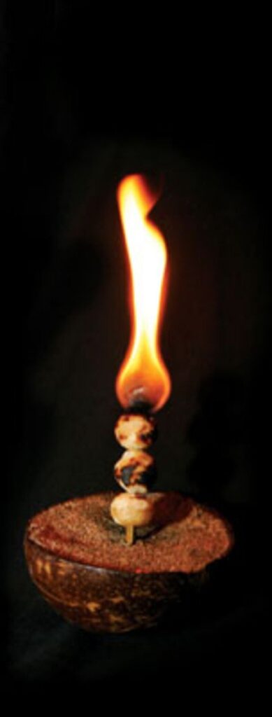
“The oily kernels are dried and strung on a skewer such as a coconut leaf midrib (lama kū – torch.) Each nut in the string burns for about 3-minutes and emits a somewhat fragrant smoke.” (CTAHR)
These same more rigid midribs (of coconut frond – or bamboo) furnished the rods on which it was the task of children to string kukui nut kernels; these were burned as candles (lama). (Krauss)
“When (the Hawaiians) use them in their houses, ten or twelve are strung on the thin stalk of the cocoa-nut leaf, and look like a number of pealed chesnuts on a long skewer. The person who has charge of them lights a nut at one end of the stick, and hold it up, till the oil it contains is consumed, when the flame kindles on the one beneath it, and he breaks off the extinct nut with a short piece of wood, which serves as a pair of snuffers. Each nut will burn two or three minutes, and, it attended, give a tolerable light.” (Ellis, 1826)
“Large quantities of kukui, or candle nuts, were hanging up in long strings in different parts of his house. … Sometimes the natives burn them to charcoal, which they pulverize, and use tattooing their skin, painting their canoes, surf-boards, idols or drums; but they are generally used as a substitute for candles or lamps.”
“When employed for fishing by torchlight, four or five strings are enclosed in the leaves of the pandanus, which not only keeps them together, but adds to the light they give.” (Ellis, 1826)
“As the sky darkened, men prowled the shallow waters of lagoons with torches and spears. ‘Candles’ were made by stringing dried nutmeats of the oily kukui nut on thin skewers of bamboo.”
“The top nut was ignited, and as it burned out it ignited the nut below it. For a fishing torch, clusters of these candles were lighted and carried in a bamboo tube (candlenut torch.)” (HPA)
Reportedly, on March 17, 1930, Territorial Governor Lawrence McCully Judd issued a proclamation declaring the coconut palm or niu (Cocos nucifera) the official tree of the Territory of Hawai’i. (Choy)
But on May 1, 1959, the 30th Territorial Legislature passed Joint Resolution No. 3, which designated the kukui the official tree. (Choy) State law, HRS §5-8, designated the Kukui as the State tree.


-ca_1850")


mother Kamehameha II, Kamehameha III-1790")

