Heinrich Zimmermann (1741–1805) was one of the few Germans who participated in James Cook’s voyages of discovery. As a sailor in the third voyage (1776 to 1779), he kept a journal that later became the basis for his account Reise um die Welt, which was translated into English and later published as Account of the Third Voyage of Captain Cook.
“I commenced my wanderings in the year 1770, and, being unable to obtain work in my profession of belt-maker, partly because at that time I had little knowledge of foreign languages and partly on account of the lack of artisans, I was forced to take to other means of earning my livelihood …”
“… so that at one time I was employed at Geneva by a brazier, and also by a gilder; at another time at Lyons by a bellfounder; and again by a sword-cutler at Paris ; and in a sugar-refinery in London.”
“The natural courage of a native of the Palatinate determined me to adopt a seafaring life, and as in the year 1776 two war-sloops, the old ‘Resolution’ and ‘Discovery,’ were being sent out by Great Britain on an exploring expedition, on 11th March of the same year I signed on the latter ship as a common sailor.”
“The ‘Resolution’ had 112 men and sixteen guns, and the ‘Discovery’ 72 men and twelve guns on board: the former was commanded by the famous circumnavigator Captain James Cook as Commodore, and the latter by Captain Charles Clerke.”
“On 12th May of the aforesaid year – 1776 – both ships put to sea from the port of Deptford, and after we had laid in the requisite supplies of ammunition at Woolwich and of provisions at Plymouth the ‘Resolution’ sailed on 12th July, her immediate goal being the Cape of Good Hope.”
“The ‘Discovery’ was prevented from leaving at this time, but she followed the ‘Resolution’ on 1st August. The principal object of the voyage was the discovery of a passage between the two continents of America and Asia on the north-western or north-eastern side …”
“… and for this a prize of £10,000 had been offered, or a further sum of £5,000 if we reached the 5th degree from the Pole. The well-known Tahitian O-mai was also to be returned to his home.”
“From Plymouth our course was set towards the promontory of the Cape of Good Hope, almost directly south, and past the Canary Islands, off the kingdom of Morocco, in Africa, and we bore towards the south-east without setting foot upon a single island.”
After sailing in areas of the South Pacific, Zimmermann notes, “our supply of fresh water becoming very reduced, we were obliged to distil sea-water. …”
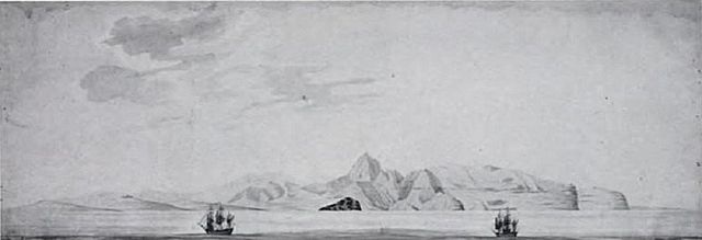
“By good fortune we discovered, on 20th January [1778], in about 22 degrees north latitude and 225 east longitude, a somewhat hilly island, and were encouraged to think that we might find fresh water here. Many of the inhabitants came off to us in their canoes; they were the finest of all the native peoples we had met with.”
“We tried to tempt them to the ships with friendly signs and by exhibiting various presents; these latter they at first refused, and from their evident astonishment at our ships we perceived that they had never seen ships before.”
“One of them at length ventured to come close to the ships, and he was presented with a piece of red cloth; whereupon his companions took courage and approached likewise, and they too received presents.”
“On being shown the live pigs which we had on board, and which we had brought with us from Tahiti, they immediately cried Booa, and from this and from the rest of their speech it was evident that the language in use here was not unlike that of the Tahitians.”
“They pointed to the island and made signs to indicate to us that they too had pigs, and they understood at once when we indicated that we would be glad to be supplied with some of these animals. Thereupon some of them returned to the island and brought a number of pigs, which they presented to us without asking anything in return.”
“They had now become more trusting, and even ventured to come aboard the ships: we learned that the name of the island was Nihau, and that there was fresh water close by.”
“Captain Cook now ordered out three boats to search for this fresh water, and while preparations were in progress one of the natives stole a kitchen knife from the kitchen of the ‘Resolution,’ sprang overboard, and hurried ashore in his canoe. We followed him in the boats which had just been lowered, but, as he ventured into the raging surf, we were unable to catch him.”
“We fired a few shots after him, but fortunately did not hit him, and his fellow-countrymen hurrying the thief with his booty away to a place of safety, we did not obtain our stolen property.”
“By Captain Cook’s orders, the three boats, under the command of Lieutenant Williamson, an Irishman, then went ashore to look for water, and a suitable landing-place was found.”
“While we were still a short distance from the shore the inhabitants gathered there to the number of about fifty, ran into the sea, lifted up Lieutenant Williamson’s boat, together with its whole crew, and were about to carry it ashore on their backs.”
“The men in the boats could not at first understand whether this was an act of friendship or of enmity, and they struck at the fingers of the islanders with the oars; but as the islanders refused to desist from their doubtful attentions, and one of them attempted to snatch Lieutenant Williamson’s gun out of his hand, the Lieutenant shot the man down on the spot.”
“The rest of the natives at once dropped the boat into the water, picked up the wounded man, and with great lamentations carried him away into the bush.”
“We now returned to the ship and informed Captain Cook of what had occurred. The captain reprimanded Lieutenant Williamson severely for his action, and the following day went himself with the same three boats and to the same spot on the shore.”
“A much larger crowd of inhabitants was now gathered here than on the day before. Captain Cook gave orders that no one was to leave the boats, and he gave his gun to a sailor and went ashore alone, armed only with a hunting-knife.”
“As soon as he set foot on shore all the people fell on their faces: Cook looked round him and laughed heartily; then he lifted up some of the eldest, and those who appeared from their clothing to be the aristocrats of the land, embraced them, and gave them presents.”
“The rest of the people remained on their faces, but four of them went away and brought the king, each of them holding a handful of sugar-cane over his head as a parasol.”
“The king approached quite close to Captain Cook and bowed low before him. Cook gave him a necklace of glass beads, himself hanging it round his neck; he also presented him with a mirror.”
“Only when Captain Cook had gone farther inland to look for water did the kneeling people rise to their feet. While he was absent the inhabitants brought us quantities of pigs and fruit, which they presented to us, and with which our boats were soon full.”
“On the return of Captain Cook we went back to the ships and brought them close to the place where he had located a small fresh-water stream, and, the anchor being dropped, preparations were made for laying in a supply of water.”
“Another party went ashore and traded with the natives, receiving provisions, but particularly pigs, yams, coconuts, and plantains, which were plentiful on this island, in exchange for nails, mirrors, bead necklaces, and knives.”
“The women here, besides being beautiful, were very obliging, outdoing in both these respects the women in any of the other islands in the South Seas.”
“Captain Cook had, however, forbidden us to have any dealings with them on pain of a heavy punishment; indeed, the whole crew had to submit to an examination, and any men who were found to be diseased were refused permission to go ashore.”
“Captain Cook was of opinion that there were other islands in this neighbourhood, but as the time had come for us to turn northwards, in pursuance of the main object of our voyage, we could not at this time visit those islands/nor occupy, ourselves with other discoveries, but postponed this until our return.”
“We did, however, touch at one small island which lay somewhat to the west, and about eight miles from Nihau, as the inhabitants gave us to understand that there were many yams there.”
“By barter with the islanders we obtained great quantities of these roots, which were the largest we had ever seen, most of them weighing from 15 lb. to 20 lb. Captain Cook called this island Yams Island. He presented the king with a pair of goats.”
“On 2nd February we continued without interruption our voyage towards the north-western coast of America, and began to approach our destination.” (Zimmermann)